The N6 5 postcode sector is within the county of Greater London.
Did you know? According to the 2021 Census, the N6 5 postcode sector is home to a bustling 10,326 residents!
Given that each sector allows for 400 unique postcode combinations. Letters C, I, K, M, O and V are not allowed in the last two letters of a postcode. With 241 postcodes already in use, this leaves 159 units available.
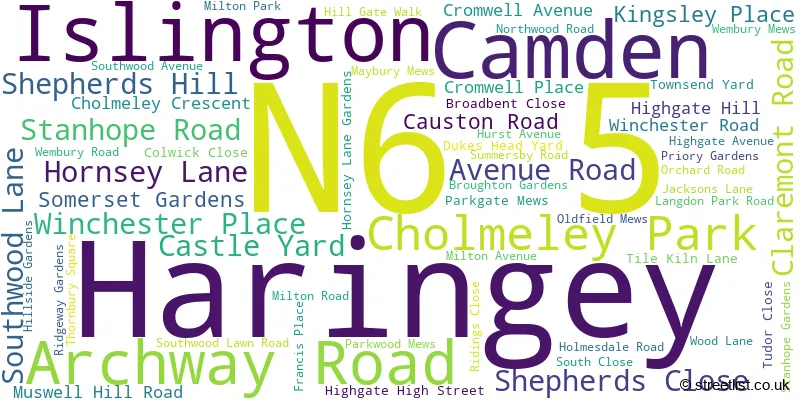
The largest settlement in the N6 5 postal code is HORNSEY followed by ISLINGTON , and LONDON .
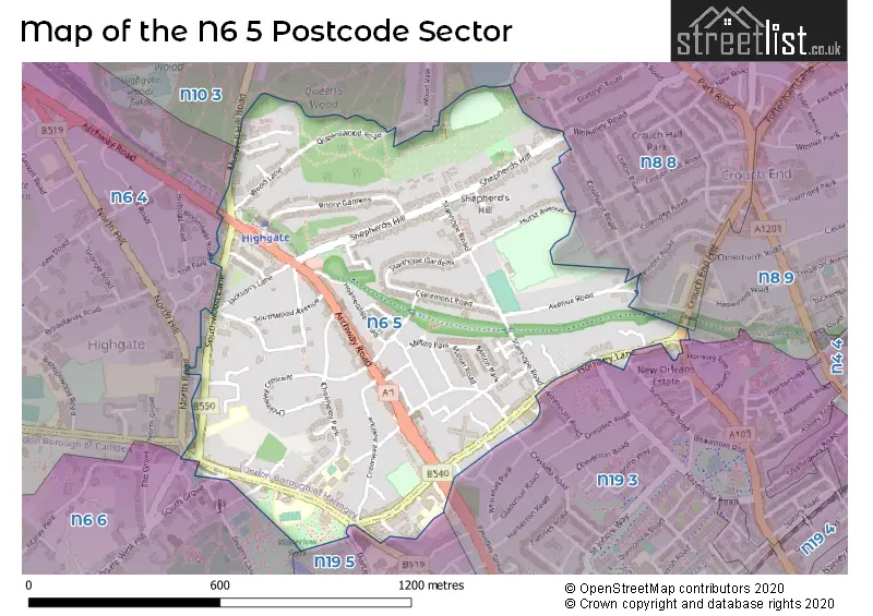
The N6 5 Postcode shares a border with N6 4 (HORNSEY ), N6 6 (LONDON ), N8 8 (HORNSEY ), N8 9 (HORNSEY , ISLINGTON ), N10 3 (HORNSEY ), N19 5 (ISLINGTON , LONDON ) and N19 3 (ISLINGTON ).
The sector is within the post town of LONDON.
N6 5 is a postcode sector within the N6 postcode district which is within the N North London postcode area.
The Royal Mail delivery office for the N6 5 postal sector is the Highgate Sdelivery Office.
The area of the N6 5 postcode sector is 0.54 square miles which is 1.41 square kilometres or 348.51 square acres.

Map of the N6 5 Postcode Sector
Explore the N6 5 postcode sector by using our free interactive map.
| N | 6 | - | 5 | X | X |
| N | 6 | Space | 5 | Letter | Letter |
Official List of Streets
Haringey (54 Streets)
Camden (2 Streets)
Unofficial Streets or Alternative Spellings
Islington
ASHMOUNT ROAD FITZWARREN GARDENS HAZELLVILLE ROAD HORNSEY RISE NEW ORLEANS WALK SUNNYSIDE ROAD WHITEHALL PARKHaringey
BLOOMFIELD ROAD COOLHURST ROAD CRESCENT ROAD CROUCH END HILL HANNAY LANE HILL GATE WALK MONTENOTTE ROAD PARK WALK PARKGATE MEWS THE PARK BOUNDARY OAK WALK BRIDGEPOINT PLACE BULLENS YARD DUKES POINT NETHERLEIGH CLOSE PARKLAND WALK PARKLANDS PEACOCK WALK POUND LANE QUEENS WOOD ROAD THE BANK THE LOWER PATH THE WILDLIFE TRAIL THE WOODLAND WALK WYCHWOOD ENDCamden
BISHAM GARDENS DARTMOUTH PARK HILL POND SQUARE SOUTH GROVEWeather Forecast for N6 5
Press Button to Show Forecast for Hampstead Heath Youth Hostel
| Time Period | Icon | Description | Temperature | Rain Probability | Wind |
|---|---|---|---|---|---|
| 12:00 to 15:00 | Cloudy | 10.0°C (feels like 7.0°C) | 10.00% | W 11 mph | |
| 15:00 to 18:00 | Cloudy | 10.0°C (feels like 8.0°C) | 49.00% | W 9 mph | |
| 18:00 to 21:00 | Cloudy | 8.0°C (feels like 6.0°C) | 9.00% | N 7 mph | |
| 21:00 to 00:00 | Cloudy | 7.0°C (feels like 5.0°C) | 8.00% | ENE 7 mph |
Press Button to Show Forecast for Hampstead Heath Youth Hostel
| Time Period | Icon | Description | Temperature | Rain Probability | Wind |
|---|---|---|---|---|---|
| 00:00 to 03:00 | Cloudy | 6.0°C (feels like 3.0°C) | 5.00% | ENE 7 mph | |
| 03:00 to 06:00 | Cloudy | 5.0°C (feels like 2.0°C) | 4.00% | NE 7 mph | |
| 06:00 to 09:00 | Cloudy | 4.0°C (feels like 1.0°C) | 4.00% | NE 7 mph | |
| 09:00 to 12:00 | Partly cloudy (day) | 7.0°C (feels like 5.0°C) | 2.00% | ENE 7 mph | |
| 12:00 to 15:00 | Cloudy | 10.0°C (feels like 9.0°C) | 9.00% | E 7 mph | |
| 15:00 to 18:00 | Overcast | 10.0°C (feels like 9.0°C) | 14.00% | ENE 7 mph | |
| 18:00 to 21:00 | Cloudy | 10.0°C (feels like 8.0°C) | 11.00% | NE 7 mph | |
| 21:00 to 00:00 | Cloudy | 7.0°C (feels like 4.0°C) | 11.00% | E 7 mph |
Press Button to Show Forecast for Hampstead Heath Youth Hostel
| Time Period | Icon | Description | Temperature | Rain Probability | Wind |
|---|---|---|---|---|---|
| 00:00 to 03:00 | Cloudy | 5.0°C (feels like 3.0°C) | 12.00% | ENE 7 mph | |
| 03:00 to 06:00 | Cloudy | 4.0°C (feels like 2.0°C) | 18.00% | NE 7 mph | |
| 06:00 to 09:00 | Overcast | 5.0°C (feels like 2.0°C) | 24.00% | NE 7 mph | |
| 09:00 to 12:00 | Cloudy | 9.0°C (feels like 7.0°C) | 16.00% | ENE 9 mph | |
| 12:00 to 15:00 | Overcast | 11.0°C (feels like 9.0°C) | 20.00% | E 9 mph | |
| 15:00 to 18:00 | Light rain | 12.0°C (feels like 10.0°C) | 52.00% | E 11 mph | |
| 18:00 to 21:00 | Light rain | 11.0°C (feels like 8.0°C) | 53.00% | ENE 9 mph | |
| 21:00 to 00:00 | Light rain | 9.0°C (feels like 6.0°C) | 51.00% | NE 11 mph |
Press Button to Show Forecast for Hampstead Heath Youth Hostel
| Time Period | Icon | Description | Temperature | Rain Probability | Wind |
|---|---|---|---|---|---|
| 00:00 to 03:00 | Light rain | 9.0°C (feels like 6.0°C) | 54.00% | NE 9 mph | |
| 03:00 to 06:00 | Light rain shower (night) | 9.0°C (feels like 7.0°C) | 45.00% | ESE 9 mph | |
| 06:00 to 09:00 | Overcast | 9.0°C (feels like 7.0°C) | 51.00% | SE 7 mph | |
| 09:00 to 12:00 | Light rain shower (day) | 10.0°C (feels like 8.0°C) | 47.00% | SE 9 mph | |
| 12:00 to 15:00 | Heavy rain shower (day) | 12.0°C (feels like 10.0°C) | 63.00% | SSW 9 mph | |
| 15:00 to 18:00 | Light rain shower (day) | 13.0°C (feels like 11.0°C) | 42.00% | SW 11 mph | |
| 18:00 to 21:00 | Partly cloudy (day) | 11.0°C (feels like 9.0°C) | 14.00% | SW 11 mph | |
| 21:00 to 00:00 | Overcast | 10.0°C (feels like 8.0°C) | 11.00% | SW 7 mph |
Schools and Places of Education Within the N6 5 Postcode Sector
St Aloysius RC College
Voluntary aided school
Hornsey Lane, London, , N6 5LY
Head: Ms Paula Whyte
Ofsted Rating: Good
Inspection: 2022-06-08 (687 days ago)
Website: Visit St Aloysius RC College Website
Phone: 02075617800
Number of Pupils: 515
Whitehall Park School
Free schools
106 Hornsey Lane, London, , N6 5EP
Head: Mrs Nicola Coyle
Ofsted Rating: Good
Inspection: 2022-09-22 (581 days ago)
Website: Visit Whitehall Park School Website
Phone: 02075610113
Number of Pupils: 266
House Prices in the N6 5 Postcode Sector
| Type of Property | 2018 Average | 2018 Sales | 2017 Average | 2017 Sales | 2016 Average | 2016 Sales | 2015 Average | 2015 Sales |
|---|---|---|---|---|---|---|---|---|
| Detached | £1,470,000 | 3 | £3,200,000 | 2 | £3,098,333 | 6 | £1,527,500 | 4 |
| Semi-Detached | £2,401,429 | 7 | £1,860,577 | 13 | £2,441,222 | 9 | £1,882,357 | 14 |
| Terraced | £1,564,974 | 19 | £1,618,573 | 29 | £1,549,857 | 21 | £1,475,160 | 25 |
| Flats | £666,650 | 87 | £664,498 | 124 | £726,025 | 113 | £608,926 | 126 |
Important Postcodes N6 5 in the Postcode Sector
N6 5AA is the postcode for Jacksons Lane, 269a Archway Road
N6 5EP is the postcode for Whitehall Park School, 106 Hornsey Lane
N6 5EW is the postcode for University of Westminster, Furnival House, 50 Cholmeley Park
N6 5HF is the postcode for BRUNNER HOUSE, Channing School, Highgate Hill, MAIN BUILDING, Channing School, Highgate Hill, FOUNDER'S HALL, Channing School, Highgate Hill, NEW HALL, Channing School, Highgate Hill, and 6TH FORM CENTRE & SPORTS HALL, Channing School, Highgate Hill
N6 5JR is the postcode for MAIN BUILDING, Channing Junior School, 1 Highgate High Street, and SPORTS HALL, Channing Junior School, 1 Highgate High Street
N6 5LY is the postcode for GYM BLOCK, St. Aloysius College, Hornsey Lane, St Aloysius College, 32 Hornsey Lane, St. Aloysius College, Hornsey Lane, MUSIC BLOCK, St. Aloysius College, Hornsey Lane, and St Aloysius College, 32 Hornsey Lane, Islington
| The N6 5 Sector is within these Local Authorities |
|
|---|---|
| The N6 5 Sector is within these Counties |
|
| The N6 5 Sector is within these Water Company Areas |
|