The N7 9 postcode sector is within the county of Greater London.
Did you know? According to the 2021 Census, the N7 9 postcode sector is home to a bustling 11,542 residents!
Given that each sector allows for 400 unique postcode combinations. Letters C, I, K, M, O and V are not allowed in the last two letters of a postcode. With 188 postcodes already in use, this leaves 212 units available.
The largest settlements in the N7 9 postal code are ISLINGTON and LONDON .
The N7 9 Postcode shares a border with N1 1 (ISLINGTON ), N1 0 (ISLINGTON ), N7 0 (ISLINGTON , LONDON ), N7 6 (ISLINGTON ), N1C 4 (LONDON ), NW1 9 (LONDON ) and N7 8 (ISLINGTON ).
The sector is within the post town of LONDON.
N7 9 is a postcode sector within the N7 postcode district which is within the N North London postcode area.
The Royal Mail delivery office for the N7 9 postal sector is the Holloway Sdelivery Office.
The area of the N7 9 postcode sector is 0.35 square miles which is 0.92 square kilometres or 226.40 square acres.

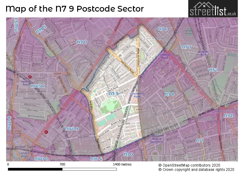
Map of the N7 9 Postcode Sector
Explore the N7 9 postcode sector by using our free interactive map.
| N | 7 | - | 9 | X | X |
| N | 7 | Space | 9 | Letter | Letter |
Official List of Streets
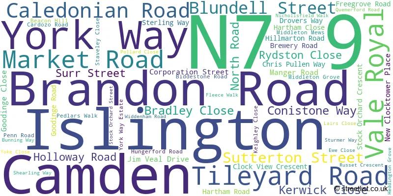
Islington (55 Streets)
Unofficial Streets or Alternative Spellings
Islington
COTTAGE ROAD LORAINE ROAD MACKENZIE ROAD PARKHURST ROAD ROWSTOCK GARDENS TOLLINGTON ROAD WHEELWRIGHT STREET WILLIAMSON STREETCamden
AGAR GROVE BROADFIELD LANE CAMDEN MEWS CAMDEN PARK ROAD CAMDEN ROAD CLIFF ROAD MAIDEN LANE CARPTENTERS MEWS COPENHAGEN TUNNEL FRED WHITE WALK FREDERICA STREET KINGS COURT LONDON POWER TUNNELS ST JOHNS WOOD - HACKNEY NEW CLOCK TOWER PLACE NICHOLSFIELD WALK ST PAULS MEWS THE DRIVEWeather Forecast for N7 9
Press Button to Show Forecast for Arsenal F.C.
| Time Period | Icon | Description | Temperature | Rain Probability | Wind |
|---|---|---|---|---|---|
| 03:00 to 06:00 | Cloudy | 7.0°C (feels like 5.0°C) | 5.00% | SSW 7 mph | |
| 06:00 to 09:00 | Cloudy | 7.0°C (feels like 5.0°C) | 6.00% | SW 7 mph | |
| 09:00 to 12:00 | Cloudy | 9.0°C (feels like 7.0°C) | 9.00% | WSW 7 mph | |
| 12:00 to 15:00 | Overcast | 11.0°C (feels like 8.0°C) | 11.00% | W 11 mph | |
| 15:00 to 18:00 | Light rain shower (day) | 11.0°C (feels like 9.0°C) | 50.00% | WNW 7 mph | |
| 18:00 to 21:00 | Cloudy | 9.0°C (feels like 7.0°C) | 47.00% | NNW 7 mph | |
| 21:00 to 00:00 | Cloudy | 8.0°C (feels like 6.0°C) | 8.00% | ENE 7 mph |
Press Button to Show Forecast for Arsenal F.C.
| Time Period | Icon | Description | Temperature | Rain Probability | Wind |
|---|---|---|---|---|---|
| 00:00 to 03:00 | Cloudy | 7.0°C (feels like 5.0°C) | 5.00% | ENE 7 mph | |
| 03:00 to 06:00 | Cloudy | 6.0°C (feels like 3.0°C) | 4.00% | NE 7 mph | |
| 06:00 to 09:00 | Cloudy | 5.0°C (feels like 3.0°C) | 4.00% | NE 7 mph | |
| 09:00 to 12:00 | Cloudy | 8.0°C (feels like 6.0°C) | 4.00% | ENE 7 mph | |
| 12:00 to 15:00 | Cloudy | 10.0°C (feels like 9.0°C) | 11.00% | E 4 mph | |
| 15:00 to 18:00 | Cloudy | 11.0°C (feels like 10.0°C) | 12.00% | ENE 4 mph | |
| 18:00 to 21:00 | Cloudy | 10.0°C (feels like 9.0°C) | 13.00% | E 7 mph | |
| 21:00 to 00:00 | Cloudy | 7.0°C (feels like 5.0°C) | 11.00% | E 7 mph |
Press Button to Show Forecast for Arsenal F.C.
| Time Period | Icon | Description | Temperature | Rain Probability | Wind |
|---|---|---|---|---|---|
| 00:00 to 03:00 | Cloudy | 6.0°C (feels like 4.0°C) | 17.00% | ENE 7 mph | |
| 03:00 to 06:00 | Cloudy | 5.0°C (feels like 3.0°C) | 18.00% | NE 7 mph | |
| 06:00 to 09:00 | Cloudy | 6.0°C (feels like 4.0°C) | 21.00% | NE 7 mph | |
| 09:00 to 12:00 | Overcast | 10.0°C (feels like 8.0°C) | 18.00% | ENE 9 mph | |
| 12:00 to 15:00 | Cloudy | 12.0°C (feels like 10.0°C) | 14.00% | E 9 mph | |
| 15:00 to 18:00 | Light rain | 12.0°C (feels like 10.0°C) | 51.00% | E 11 mph | |
| 18:00 to 21:00 | Light rain | 11.0°C (feels like 9.0°C) | 54.00% | ENE 9 mph | |
| 21:00 to 00:00 | Light rain | 10.0°C (feels like 7.0°C) | 54.00% | ENE 11 mph |
Press Button to Show Forecast for Arsenal F.C.
| Time Period | Icon | Description | Temperature | Rain Probability | Wind |
|---|---|---|---|---|---|
| 00:00 to 03:00 | Heavy rain | 9.0°C (feels like 7.0°C) | 74.00% | NE 9 mph | |
| 03:00 to 06:00 | Light rain | 10.0°C (feels like 8.0°C) | 56.00% | ESE 9 mph | |
| 06:00 to 09:00 | Light rain | 10.0°C (feels like 8.0°C) | 52.00% | SE 7 mph | |
| 09:00 to 12:00 | Light rain shower (day) | 11.0°C (feels like 9.0°C) | 43.00% | SE 9 mph | |
| 12:00 to 15:00 | Heavy rain shower (day) | 12.0°C (feels like 11.0°C) | 60.00% | S 9 mph | |
| 15:00 to 18:00 | Light rain shower (day) | 14.0°C (feels like 12.0°C) | 39.00% | SSW 11 mph | |
| 18:00 to 21:00 | Partly cloudy (day) | 12.0°C (feels like 10.0°C) | 13.00% | SW 11 mph | |
| 21:00 to 00:00 | Cloudy | 11.0°C (feels like 9.0°C) | 9.00% | SSW 7 mph |
Schools and Places of Education Within the N7 9 Postcode Sector
Hungerford School
Academy sponsor led
249 Hungerford Road, London, , N7 9LF
Head: Ms Jo Stephens
Ofsted Rating: Good
Inspection: 2022-10-06 (567 days ago)
Website: Visit Hungerford School Website
Phone: 02076191000
Number of Pupils: 144
Robert Blair School and Children's Centre
Community school
Brewery Road, London, , N7 9QJ
Head: Ms Michelle Bahn
Ofsted Rating: Good
Inspection: 2019-05-10 (1812 days ago)
Website: Visit Robert Blair School and Children's Centre Website
Phone: 02076074115
Number of Pupils: 231
The Bridge School
Academy special converter
251 Hungerford Road, London, , N7 9LD
Head: Penny Barratt
Ofsted Rating: Outstanding
Inspection: 2019-12-12 (1596 days ago)
Website: Visit The Bridge School Website
Phone: 02076191000
Number of Pupils: 236
House Prices in the N7 9 Postcode Sector
| Type of Property | 2018 Average | 2018 Sales | 2017 Average | 2017 Sales | 2016 Average | 2016 Sales | 2015 Average | 2015 Sales |
|---|---|---|---|---|---|---|---|---|
| Detached | £0 | 0 | £1,650,000 | 1 | £0 | 0 | £2,075,000 | 1 |
| Semi-Detached | £1,650,000 | 2 | £1,572,500 | 2 | £2,950,000 | 1 | £1,289,375 | 4 |
| Terraced | £708,550 | 10 | £954,444 | 9 | £1,016,800 | 10 | £847,333 | 3 |
| Flats | £509,416 | 85 | £548,107 | 111 | £497,937 | 75 | £470,333 | 99 |
Important Postcodes N7 9 in the Postcode Sector
N7 9BA is the postcode for 465, Caledonian Road, and New Hall, 465, Caledonian Road
N7 9BH is the postcode for The Quarto Group Incorporated, The Old Brewery, 6 Blundell Street
N7 9BQ is the postcode for British Transport Police, 423-425 Caledonian Road
N7 9ED is the postcode for Units 11-17, Brewery Road
N7 9EH is the postcode for Goodinge Day Centre, 150 Corporation Street, Islington
N7 9EW is the postcode for Goodinge Health Centre, 20 North Road
N7 9HH is the postcode for Royal Mail, Unit 9-10 Hanover Trading Estate, 1-3 North Road
N7 9LD is the postcode for The Bridge School, 251 Hungerford Road
N7 9LF is the postcode for Hungerford Primary School, Hungerford Road
N7 9LH is the postcode for 10 Goodinge Road, Islington
N7 9PL is the postcode for Market Road Sports Pavilion, Market Road, Islington Tennis Centre, Market Road, and Islington Tennis Centre and Gym, Market Road
N7 9QJ is the postcode for Robert Blair Primary School, Brewery Road, and ROBERT BLAIR PRIMARY SCHOOL, 27 BREWERY ROAD, ISLINGTON
| The N7 9 Sector is within these Local Authorities |
|
|---|---|
| The N7 9 Sector is within these Counties |
|
| The N7 9 Sector is within these Water Company Areas |
|