The NE12 postcode district is a postal district located in the NE Newcastle upon Tyne postcode area with a population of 36,636 residents according to the 2021 England and Wales Census.
The area of the NE12 postcode district is 5.52 square miles which is 14.29 square kilometres or 3,530.44 acres.
Currently, the NE12 district has about 841 postcode units spread across 5 geographic postcode sectors.
Given that each sector allows for 400 unique postcode combinations, the district has a capacity of 2,000 postcodes. With 841 postcodes already in use, this leaves 1159 units available.
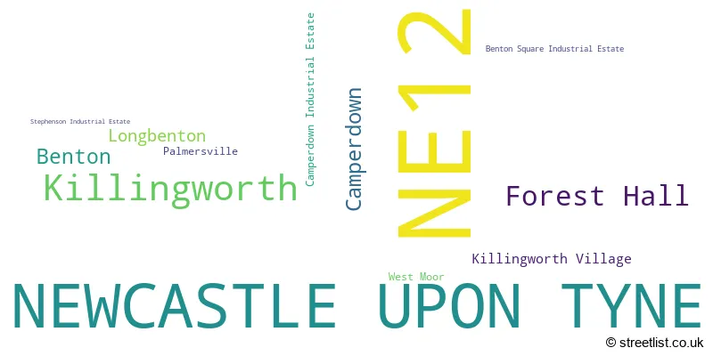
The largest settlement in the NE12 postal code is NEWCASTLE UPON TYNE followed by Killingworth, and Forest Hall.
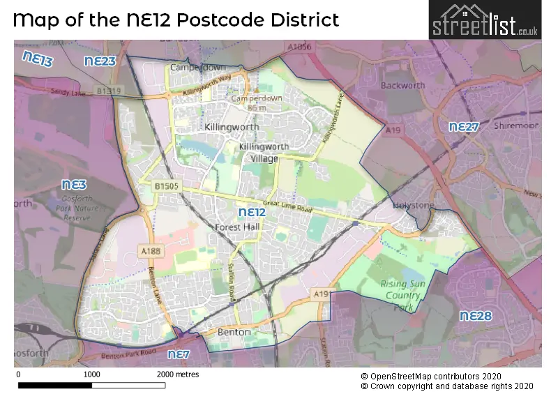
The NE12 Postcode shares a border with NE28 (WALLSEND), NE27 (Shiremoor, Backworth, West Allotment), NE3 (NEWCASTLE UPON TYNE, Gosforth, South Gosforth), NE7 (NEWCASTLE UPON TYNE, High Heaton, Benton), NE13 (NEWCASTLE UPON TYNE, Wideopen, Seaton Burn) and NE23 (CRAMLINGTON, Dudley, Seghill).
The primary settlement in the NE12 postcode district is Newcastle upon Tyne, located in Tyne & Wear. Other significant settlements in the district include Killingworth, Camperdown, Camperdown Industrial Estate, Killingworth Village, Stephenson Industrial Estate, Forest Hall, West Moor, Benton, Longbenton, and Palmersville. The most significant post town in the district is Newcastle upon Tyne.
For the district NE12, we have data on 6 postcode sectors. Here's a breakdown: The sector NE12 2 is non-geographic. It's often designated for PO Boxes, large organisations, or special services. The sector NE12 5, covers Camperdown and Killingworth and Camperdown Industrial Estate in Tyne & Wear. The sector NE12 6, covers Newcastle Upon Tyne and Killingworth in Tyne & Wear. The sector NE12 7, covers Newcastle Upon Tyne and Forest Hall and Killingworth in Tyne & Wear. The sector NE12 8, covers Newcastle Upon Tyne in Tyne & Wear. The sector NE12 9, covers Newcastle Upon Tyne and Forest Hall in Tyne & Wear.

Map of the NE12 Postcode District
Explore the NE12 postcode district by using our free interactive map.
When it comes to local government, postal geography often disregards political borders. However, for a breakdown in the NE12 District: the district mostly encompasses the North Tyneside District (B) area with a total of 852 postcodes.
Recent House Sales in NE12
| Date | Price | Address |
|---|---|---|
| 20/10/2023 | £185,000 | Meadow Gardens, Camperdown, Newcastle Upon Tyne, NE12 5AR |
| 20/10/2023 | £195,000 | Southgate, Newcastle Upon Tyne, NE12 6ED |
| 13/10/2023 | £130,000 | Garth Twentyseven, Newcastle Upon Tyne, NE12 6AW |
| 13/10/2023 | £140,000 | Harriot Drive, Newcastle Upon Tyne, NE12 7EU |
| 13/10/2023 | £110,000 | Allanville, Camperdown, Newcastle Upon Tyne, NE12 5XS |
| 15/09/2023 | £105,000 | Victoria Court, West Moor, Newcastle Upon Tyne, NE12 7PE |
| 13/09/2023 | £375,000 | Williams Park, Newcastle Upon Tyne, NE12 8BL |
| 12/09/2023 | £100,000 | Victoria Court, West Moor, Newcastle Upon Tyne, NE12 7PE |
| 08/09/2023 | £120,000 | Garth Twenty, Newcastle Upon Tyne, NE12 6LP |
| 05/09/2023 | £350,000 | West Lane, Killingworth, Newcastle Upon Tyne, NE12 7BD |
Weather Forecast for NE12
Press Button to Show Forecast for Forest Hall (Tyne & Wear)
| Time Period | Icon | Description | Temperature | Rain Probability | Wind |
|---|---|---|---|---|---|
| 09:00 to 12:00 | Cloudy | 6.0°C (feels like 2.0°C) | 12.00% | N 13 mph | |
| 12:00 to 15:00 | Cloudy | 7.0°C (feels like 4.0°C) | 4.00% | N 13 mph | |
| 15:00 to 18:00 | Partly cloudy (day) | 7.0°C (feels like 4.0°C) | 1.00% | NNE 11 mph | |
| 18:00 to 21:00 | Partly cloudy (day) | 7.0°C (feels like 5.0°C) | 1.00% | ENE 7 mph | |
| 21:00 to 00:00 | Cloudy | 6.0°C (feels like 4.0°C) | 5.00% | SSW 7 mph |
Press Button to Show Forecast for Forest Hall (Tyne & Wear)
| Time Period | Icon | Description | Temperature | Rain Probability | Wind |
|---|---|---|---|---|---|
| 00:00 to 03:00 | Cloudy | 6.0°C (feels like 3.0°C) | 5.00% | W 9 mph | |
| 03:00 to 06:00 | Cloudy | 5.0°C (feels like 2.0°C) | 11.00% | NW 11 mph | |
| 06:00 to 09:00 | Cloudy | 5.0°C (feels like 1.0°C) | 8.00% | NW 11 mph | |
| 09:00 to 12:00 | Cloudy | 6.0°C (feels like 2.0°C) | 8.00% | NNW 11 mph | |
| 12:00 to 15:00 | Cloudy | 7.0°C (feels like 4.0°C) | 8.00% | N 11 mph | |
| 15:00 to 18:00 | Cloudy | 7.0°C (feels like 4.0°C) | 5.00% | NNE 11 mph | |
| 18:00 to 21:00 | Partly cloudy (day) | 7.0°C (feels like 4.0°C) | 2.00% | NNE 9 mph | |
| 21:00 to 00:00 | Clear night | 5.0°C (feels like 3.0°C) | 1.00% | NE 7 mph |
Press Button to Show Forecast for Forest Hall (Tyne & Wear)
| Time Period | Icon | Description | Temperature | Rain Probability | Wind |
|---|---|---|---|---|---|
| 00:00 to 03:00 | Partly cloudy (night) | 4.0°C (feels like 2.0°C) | 1.00% | NNE 4 mph | |
| 03:00 to 06:00 | Cloudy | 4.0°C (feels like 2.0°C) | 4.00% | NW 4 mph | |
| 06:00 to 09:00 | Cloudy | 4.0°C (feels like 2.0°C) | 5.00% | NW 4 mph | |
| 09:00 to 12:00 | Cloudy | 6.0°C (feels like 4.0°C) | 7.00% | ENE 7 mph | |
| 12:00 to 15:00 | Cloudy | 8.0°C (feels like 5.0°C) | 8.00% | E 9 mph | |
| 15:00 to 18:00 | Cloudy | 8.0°C (feels like 5.0°C) | 7.00% | E 9 mph | |
| 18:00 to 21:00 | Cloudy | 7.0°C (feels like 5.0°C) | 7.00% | E 9 mph | |
| 21:00 to 00:00 | Cloudy | 6.0°C (feels like 3.0°C) | 7.00% | ESE 7 mph |
Press Button to Show Forecast for Forest Hall (Tyne & Wear)
| Time Period | Icon | Description | Temperature | Rain Probability | Wind |
|---|---|---|---|---|---|
| 00:00 to 03:00 | Cloudy | 5.0°C (feels like 3.0°C) | 21.00% | ESE 7 mph | |
| 03:00 to 06:00 | Cloudy | 5.0°C (feels like 2.0°C) | 8.00% | ESE 7 mph | |
| 06:00 to 09:00 | Cloudy | 6.0°C (feels like 3.0°C) | 8.00% | ESE 7 mph | |
| 09:00 to 12:00 | Overcast | 7.0°C (feels like 5.0°C) | 14.00% | ESE 11 mph | |
| 12:00 to 15:00 | Overcast | 8.0°C (feels like 5.0°C) | 16.00% | E 13 mph | |
| 15:00 to 18:00 | Cloudy | 8.0°C (feels like 5.0°C) | 12.00% | E 13 mph | |
| 18:00 to 21:00 | Cloudy | 8.0°C (feels like 4.0°C) | 11.00% | E 13 mph | |
| 21:00 to 00:00 | Clear night | 7.0°C (feels like 4.0°C) | 9.00% | ENE 11 mph |
Where is the NE12 Postcode District?
The postcode district NE12 is located in Newcastle upon Tyne. It is situated near several towns in different directions. To the South East, there is Wallsend which is approximately 2.57 miles away. To the North, there is Cramlington which is around 4.17 miles away. To the North East, there is Whitley Bay which is about 4.36 miles away. To the East, there is North Shields which is approximately 4.48 miles away. Lastly, to the South, there is Gateshead which is around 6.22 miles away. Additionally, the postcode district NE12 is about 250.36 miles away from the centre of London.
The district is within the post town of NEWCASTLE UPON TYNE.
The sector has postcodes within the nation of England.
The NE12 Postcode District is in the Tyneside region of Northumberland and Tyne and Wear within the North East (England).
| Postcode Sector | Delivery Office |
|---|---|
| NE12 5 | Forest Hall Delivery Office |
| NE12 6 | Forest Hall Delivery Office |
| NE12 7 | Forest Hall Delivery Office |
| NE12 8 | Forest Hall Delivery Office |
| NE12 9 | Forest Hall Delivery Office |
| N | E | 1 | 2 | - | X | X | X |
| N | E | 1 | 2 | Space | Numeric | Letter | Letter |
Current Monthly Rental Prices
| # Bedrooms | Min Price | Max Price | Avg Price |
|---|---|---|---|
| £1,458 | £1,458 | £1,458 | |
| 1 | £625 | £763 | £665 |
| 2 | £700 | £1,850 | £1,013 |
| 3 | £750 | £1,800 | £1,025 |
| 4 | £1,650 | £2,750 | £2,200 |
| 5 | £2,000 | £2,000 | £2,000 |
Current House Prices
| # Bedrooms | Min Price | Max Price | Avg Price |
|---|---|---|---|
| £225,000 | £225,000 | £225,000 | |
| 1 | £70,000 | £182,000 | £99,917 |
| 2 | £60,000 | £300,000 | £148,444 |
| 3 | £85,000 | £475,000 | £219,959 |
| 4 | £245,000 | £600,000 | £361,288 |
| 5 | £325,000 | £750,000 | £459,998 |
| 6 | £650,000 | £650,000 | £650,000 |
Estate Agents who Operate in the NE12 District
| Logo | Name | Brand Name | Address | Contact Number | Total Properties |
|---|---|---|---|---|---|
 | Forest Hall | Pattinson Estate Agents | 17a Station Road North, Newcastle Upon Tyne, NE12 7AR | 0191 625 0253 | 18 |
 | Newcastle | Alexander Hudson Estates | Arrow Close, Newcastle upon Tyne NE12 6QN | 0191 625 1004 | 17 |
 | Forest Hall | Rook Matthews Sayer | 22 Station Road North, Forest Hall, Newcastle Upon Tyne, NE12 9AD | 0191 743 9300 | 14 |
 | High Heaton | Jan Forster Estates | 159 Benton Road, High Heaton, Newcastle Upon Tyne, NE7 7DU | 0191 625 0817 | 14 |
 | Killingworth | Lucas James | 2-3 The Killingworth Centre Killingworth Newcastle Upon Tyne NE12 6YT | 0191 743 9312 | 7 |
| Type of Property | 2018 Average | 2018 Sales | 2017 Average | 2017 Sales | 2016 Average | 2016 Sales | 2015 Average | 2015 Sales |
|---|---|---|---|---|---|---|---|---|
| Detached | £306,417 | 164 | £297,981 | 185 | £267,878 | 116 | £243,279 | 164 |
| Semi-Detached | £176,326 | 230 | £172,524 | 232 | £155,338 | 209 | £151,364 | 221 |
| Terraced | £144,792 | 267 | £141,627 | 209 | £140,130 | 223 | £134,714 | 229 |
| Flats | £90,310 | 111 | £86,194 | 79 | £88,054 | 84 | £81,291 | 85 |