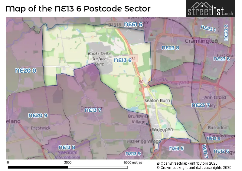
The NE13 6 postcode sector stands on the Northumberland and Tyne & Wear border.
Did you know? According to the 2021 Census, the NE13 6 postcode sector is home to a bustling 6,785 residents!
Given that each sector allows for 400 unique postcode combinations. Letters C, I, K, M, O and V are not allowed in the last two letters of a postcode. With 157 postcodes already in use, this leaves 243 units available.
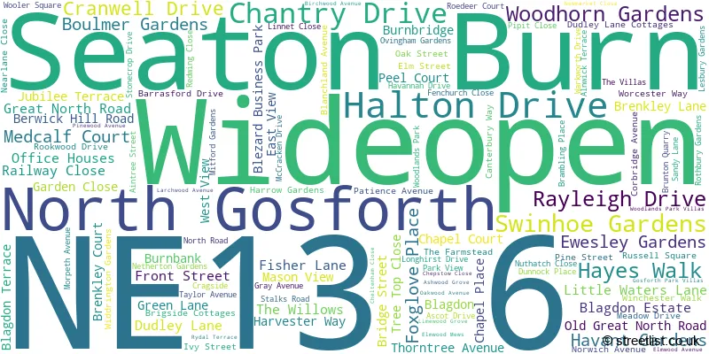
The largest settlement in the NE13 6 postal code is Wideopen followed by Seaton Burn, and North Gosforth.
The NE13 6 Postcode shares a border with NE20 9 (Ponteland, Prestwick), NE61 6 (Pegswood, Stannington, St. Mary Park), NE3 5 (NEWCASTLE UPON TYNE, Gosforth, High Gosforth Park), NE12 7 (NEWCASTLE UPON TYNE, Killingworth, Forest Hall), NE13 7 (Hazlerigg, Dinnington, Brunswick Village), NE20 0 (Ponteland, Belsay, Matfen), NE23 7 (Dudley, Seghill, Annitsford) and NE23 8 (CRAMLINGTON, The Fairways, West Meadows).
The sector is within the post town of NEWCASTLE UPON TYNE.
NE13 6 is a postcode sector within the NE13 postcode district which is within the NE Newcastle upon Tyne postcode area.
The Royal Mail delivery office for the NE13 6 postal sector is the Gosforth Delivery Office.
The area of the NE13 6 postcode sector is 7.84 square miles which is 20.30 square kilometres or 5,017.47 square acres.
The NE13 6 postcode sector is crossed by the A1 Major A road.
The NE13 6 postcode sector is crossed by the A19 Major A road.
Waterways within the NE13 6 postcode sector include the Blyth.

Map of the NE13 6 Postcode Sector
Explore the NE13 6 postcode sector by using our free interactive map.
| N | E | 1 | 3 | - | 6 | X | X |
| N | E | 1 | 3 | Space | 6 | Letter | Letter |
Official List of Streets
North Gosforth (20 Streets)
Wideopen (53 Streets)
Seaton Burn (38 Streets)
Unofficial Streets or Alternative Spellings
Dudley
ARCOT LANE DUDLEY LANE GREAT LIME ROAD AINTREE BLAGDON LANE BRENKLEY WAY BRIDGE COURT CHAPEL HOUSE CHAPELVILLE CO-OPERATIVE TERRACE HAVANNAH MINERAL LINE IVY AND ELM STREET KINGS DRIVE LEGGES DRIVE OAK AND PINE STREET SEATON BURN ROUNDABOUT SEATON FOREST SIX MILE COTTAGES WEETSLADE COURT WOOLER SQUARE COTTAGESNorth Gosforth
AUGUSTA CLOSEBrunton Park
GREAT NORTH ROADBrunswick Village
DARRELL STREETHazlerigg
COACH LANEDinnington
HORTON GRANGE ROADWeather Forecast for NE13 6
Press Button to Show Forecast for Newcastle International Airport
| Time Period | Icon | Description | Temperature | Rain Probability | Wind |
|---|---|---|---|---|---|
| 12:00 to 15:00 | Light rain shower (day) | 6.0°C (feels like 4.0°C) | 35.00% | NNE 9 mph | |
| 15:00 to 18:00 | Cloudy | 7.0°C (feels like 4.0°C) | 50.00% | N 9 mph | |
| 18:00 to 21:00 | Sunny day | 6.0°C (feels like 3.0°C) | 1.00% | NNE 9 mph | |
| 21:00 to 00:00 | Partly cloudy (night) | 3.0°C (feels like 1.0°C) | 1.00% | N 4 mph |
Press Button to Show Forecast for Newcastle International Airport
| Time Period | Icon | Description | Temperature | Rain Probability | Wind |
|---|---|---|---|---|---|
| 00:00 to 03:00 | Cloudy | 2.0°C (feels like 0.0°C) | 5.00% | NW 4 mph | |
| 03:00 to 06:00 | Cloudy | 2.0°C (feels like 0.0°C) | 13.00% | NW 4 mph | |
| 06:00 to 09:00 | Cloudy | 3.0°C (feels like 0.0°C) | 5.00% | NW 4 mph | |
| 09:00 to 12:00 | Cloudy | 6.0°C (feels like 4.0°C) | 11.00% | NNE 7 mph | |
| 12:00 to 15:00 | Cloudy | 7.0°C (feels like 5.0°C) | 9.00% | E 7 mph | |
| 15:00 to 18:00 | Cloudy | 7.0°C (feels like 5.0°C) | 7.00% | ENE 7 mph | |
| 18:00 to 21:00 | Sunny day | 6.0°C (feels like 4.0°C) | 5.00% | E 7 mph | |
| 21:00 to 00:00 | Clear night | 3.0°C (feels like 1.0°C) | 2.00% | ESE 4 mph |
Press Button to Show Forecast for Newcastle International Airport
| Time Period | Icon | Description | Temperature | Rain Probability | Wind |
|---|---|---|---|---|---|
| 00:00 to 03:00 | Clear night | 2.0°C (feels like 1.0°C) | 2.00% | SSE 4 mph | |
| 03:00 to 06:00 | Partly cloudy (night) | 2.0°C (feels like 0.0°C) | 4.00% | SSW 2 mph | |
| 06:00 to 09:00 | Sunny day | 3.0°C (feels like 2.0°C) | 6.00% | S 2 mph | |
| 09:00 to 12:00 | Cloudy | 7.0°C (feels like 5.0°C) | 11.00% | ESE 7 mph | |
| 12:00 to 15:00 | Cloudy | 9.0°C (feels like 7.0°C) | 12.00% | E 9 mph | |
| 15:00 to 18:00 | Cloudy | 8.0°C (feels like 6.0°C) | 12.00% | E 9 mph | |
| 18:00 to 21:00 | Partly cloudy (day) | 7.0°C (feels like 5.0°C) | 9.00% | E 9 mph | |
| 21:00 to 00:00 | Partly cloudy (night) | 5.0°C (feels like 3.0°C) | 10.00% | E 7 mph |
Press Button to Show Forecast for Newcastle International Airport
| Time Period | Icon | Description | Temperature | Rain Probability | Wind |
|---|---|---|---|---|---|
| 00:00 to 03:00 | Cloudy | 5.0°C (feels like 2.0°C) | 15.00% | NE 7 mph | |
| 03:00 to 06:00 | Overcast | 5.0°C (feels like 2.0°C) | 18.00% | NNE 9 mph | |
| 06:00 to 09:00 | Cloudy | 6.0°C (feels like 3.0°C) | 19.00% | NE 11 mph | |
| 09:00 to 12:00 | Light rain | 7.0°C (feels like 4.0°C) | 51.00% | NE 13 mph | |
| 12:00 to 15:00 | Heavy rain | 8.0°C (feels like 5.0°C) | 75.00% | NNE 13 mph | |
| 15:00 to 18:00 | Light rain | 8.0°C (feels like 5.0°C) | 55.00% | NNE 11 mph | |
| 18:00 to 21:00 | Heavy rain | 9.0°C (feels like 7.0°C) | 71.00% | N 7 mph | |
| 21:00 to 00:00 | Clear night | 6.0°C (feels like 4.0°C) | 9.00% | SE 7 mph |
Schools and Places of Education Within the NE13 6 Postcode Sector
Brenkley School
Other independent special school
3-5 Brenkley Way, , , NE13 6DS
Head: Ms Susan Park
Ofsted Rating: Good
Inspection: 2021-11-25 (882 days ago)
Website: Visit Brenkley School Website
Phone: 01913003663
Number of Pupils: 20
Greenfields Community Primary School
Foundation school
Taylor Avenue, Newcastle-upon-Tyne, Tyne and Wear, NE13 6NB
Head: Mrs Gemma Robertson
Ofsted Rating: Good
Inspection: 2022-10-06 (567 days ago)
Website: Visit Greenfields Community Primary School Website
Phone: 01916250100
Number of Pupils: 235
Hazlewood Community Primary School
Foundation school
Canterbury Way, Newcastle-upon-Tyne, Tyne and Wear, NE13 6JJ
Head: Mr Stephane Bommel
Ofsted Rating: Good
Inspection: 2023-03-14 (408 days ago)
Website: Visit Hazlewood Community Primary School Website
Phone: 01919178545
Number of Pupils: 298
North Gosforth Academy
Academy sponsor led
Dudley Lane, Newcastle-upon-Tyne, Tyne and Wear, NE13 6EJ
Head: Principal Pete Fox
Ofsted Rating: Requires improvement
Inspection: 2022-04-28 (728 days ago)
Website: Visit North Gosforth Academy Website
Phone: 01912361700
Number of Pupils: 554
House Prices in the NE13 6 Postcode Sector
| Type of Property | 2018 Average | 2018 Sales | 2017 Average | 2017 Sales | 2016 Average | 2016 Sales | 2015 Average | 2015 Sales |
|---|---|---|---|---|---|---|---|---|
| Detached | £309,930 | 57 | £286,440 | 48 | £281,089 | 55 | £274,261 | 62 |
| Semi-Detached | £176,499 | 108 | £163,047 | 81 | £161,583 | 65 | £162,589 | 66 |
| Terraced | £155,876 | 33 | £146,932 | 31 | £161,806 | 26 | £143,203 | 17 |
| Flats | £128,000 | 11 | £118,999 | 4 | £79,433 | 3 | £112,356 | 14 |
Important Postcodes NE13 6 in the Postcode Sector
NE13 6EJ is the postcode for WEST WING, North Gosforth Academy, Dudley Lane, MAIN BUILDING, North Gosforth Academy, Dudley Lane, Seaton Burn Community College, Dudley Lane, MAIN BUILDING, Seaton Burn Community College, Dudley Lane, and SPORTS BLOCK, Seaton Burn Community College, Dudley Lane
NE13 6JJ is the postcode for Hazlewood Community Primary School, Canterbury Way, and Woodlands Park Health Centre, Canterbury Way
NE13 6LN is the postcode for Wideopen Medical Centre, Tulach Ard, North Road
NE13 6NA is the postcode for GREENFIELDS COMMUNITY PRIMARY SCHOOL HOUSE, TAYLOR AVENUE, WIDEOPEN
NE13 6NB is the postcode for Greenfields Community Primary School, Wideopen, and Greenfields Community Primary School, Wideopen, Wideopen
| The NE13 6 Sector is within these Local Authorities |
|
|---|---|
| The NE13 6 Sector is within these Counties |
|
| The NE13 6 Sector is within these Water Company Areas |
|