The NE17 postcode district is a postal district located in the NE Newcastle upon Tyne postcode area with a population of 4,563 residents according to the 2021 England and Wales Census.
The area of the NE17 postcode district is 5.96 square miles which is 15.44 square kilometres or 3,815.46 acres.
Currently, the NE17 district has about 166 postcode units spread across 1 geographic postcode sectors.
Given that each sector allows for 400 unique postcode combinations, the district has a capacity of 400 postcodes. With 166 postcodes already in use, this leaves 234 units available.
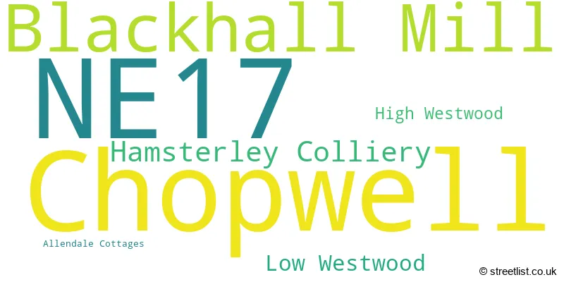
The largest settlement in the NE17 postal code is Chopwell followed by Hamsterley Colliery, and Blackhall Mill.
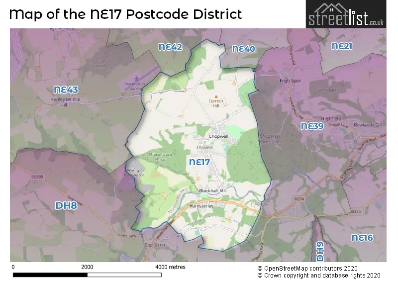
The NE17 Postcode shares a border with DH8 (CONSETT, Blackhill, Leadgate), NE42 (PRUDHOE, Ovingham, Ovington), NE43 (STOCKSFIELD, Mickley, Newton), NE39 (ROWLANDS GILL, High Spen, Hamsterley Mill) and NE40 (RYTON, Greenside, Crawcrook).
The primary settlement in the NE17 postcode district is Chopwell, located in the county of Tyne & Wear, near Newcastle upon Tyne, Northumberland. Other significant settlements within the NE17 postcode district include Hamsterley Colliery, High Westwood, and Low Westwood, all of which are also located in Tyne & Wear.
For the district NE17, we have data on 1 postcode sectors. Here's a breakdown: The sector NE17 7, covers Chopwell and Blackhall Mill in Tyne & Wear. The sector NE17 7, covers Hamsterley Colliery in Durham.
NE17 Postcode Sectors

Map of the NE17 Postcode District
Explore the NE17 postcode district by using our free interactive map.
When it comes to local government, postal geography often disregards political borders. However, for a breakdown in the NE17 District: the district mostly encompasses the Gateshead District (B) (121 postcodes), followed by the County Durham area (43 postcodes), and finally, the Northumberland area (5 postcodes).
Recent House Sales in NE17
| Date | Price | Address |
|---|---|---|
| 15/09/2023 | £48,500 | Disraeli Terrace, Chopwell, Newcastle Upon Tyne, NE17 7JL |
| 04/09/2023 | £122,000 | Victoria Terrace, Hamsterley Colliery, Newcastle Upon Tyne, NE17 7SJ |
| 29/08/2023 | £37,250 | Mersey Street, Chopwell, Newcastle Upon Tyne, NE17 7DF |
| 25/08/2023 | £61,500 | William Street, Chopwell, Newcastle Upon Tyne, NE17 7JH |
| 25/08/2023 | £56,000 | Forth Street, Chopwell, Newcastle Upon Tyne, NE17 7DJ |
| 22/08/2023 | £39,000 | Clyde Street, Chopwell, Newcastle Upon Tyne, NE17 7DH |
| 21/08/2023 | £50,000 | Nelson Terrace, Chopwell, Newcastle Upon Tyne, NE17 7JR |
| 08/08/2023 | £80,000 | Peartree Bungalows, Blackhall Mill, Newcastle Upon Tyne, NE17 7TW |
| 01/08/2023 | £39,000 | Beaconsfield Terrace, Chopwell, Newcastle Upon Tyne, NE17 7JG |
| 10/07/2023 | £60,000 | South Terrace, Chopwell, Newcastle Upon Tyne, NE17 7EW |
Weather Forecast for NE17
Press Button to Show Forecast for Powerline Mountain Bike Trail
| Time Period | Icon | Description | Temperature | Rain Probability | Wind |
|---|---|---|---|---|---|
| 18:00 to 21:00 | Partly cloudy (day) | 6.0°C (feels like 3.0°C) | 5.00% | NNE 9 mph | |
| 21:00 to 00:00 | Clear night | 2.0°C (feels like 0.0°C) | 1.00% | N 4 mph |
Press Button to Show Forecast for Powerline Mountain Bike Trail
| Time Period | Icon | Description | Temperature | Rain Probability | Wind |
|---|---|---|---|---|---|
| 00:00 to 03:00 | Partly cloudy (night) | 1.0°C (feels like -1.0°C) | 1.00% | NW 4 mph | |
| 03:00 to 06:00 | Cloudy | 1.0°C (feels like -1.0°C) | 5.00% | WNW 4 mph | |
| 06:00 to 09:00 | Cloudy | 2.0°C (feels like 0.0°C) | 5.00% | NW 4 mph | |
| 09:00 to 12:00 | Cloudy | 5.0°C (feels like 4.0°C) | 13.00% | NE 4 mph | |
| 12:00 to 15:00 | Cloudy | 7.0°C (feels like 5.0°C) | 29.00% | E 4 mph | |
| 15:00 to 18:00 | Light rain shower (day) | 7.0°C (feels like 6.0°C) | 31.00% | ENE 7 mph | |
| 18:00 to 21:00 | Sunny day | 6.0°C (feels like 5.0°C) | 4.00% | E 4 mph | |
| 21:00 to 00:00 | Partly cloudy (night) | 2.0°C (feels like 0.0°C) | 2.00% | SE 4 mph |
Press Button to Show Forecast for Powerline Mountain Bike Trail
| Time Period | Icon | Description | Temperature | Rain Probability | Wind |
|---|---|---|---|---|---|
| 00:00 to 03:00 | Partly cloudy (night) | 1.0°C (feels like 0.0°C) | 2.00% | S 2 mph | |
| 03:00 to 06:00 | Partly cloudy (night) | 1.0°C (feels like -1.0°C) | 4.00% | S 2 mph | |
| 06:00 to 09:00 | Partly cloudy (day) | 2.0°C (feels like 1.0°C) | 5.00% | SE 2 mph | |
| 09:00 to 12:00 | Cloudy | 7.0°C (feels like 5.0°C) | 12.00% | ESE 7 mph | |
| 12:00 to 15:00 | Cloudy | 9.0°C (feels like 7.0°C) | 16.00% | ESE 7 mph | |
| 15:00 to 18:00 | Cloudy | 9.0°C (feels like 7.0°C) | 12.00% | E 9 mph | |
| 18:00 to 21:00 | Partly cloudy (day) | 7.0°C (feels like 5.0°C) | 9.00% | E 9 mph | |
| 21:00 to 00:00 | Cloudy | 4.0°C (feels like 2.0°C) | 12.00% | E 4 mph |
Press Button to Show Forecast for Powerline Mountain Bike Trail
| Time Period | Icon | Description | Temperature | Rain Probability | Wind |
|---|---|---|---|---|---|
| 00:00 to 03:00 | Cloudy | 3.0°C (feels like 1.0°C) | 15.00% | NE 7 mph | |
| 03:00 to 06:00 | Cloudy | 4.0°C (feels like 1.0°C) | 16.00% | NNE 7 mph | |
| 06:00 to 09:00 | Light rain | 5.0°C (feels like 3.0°C) | 46.00% | NNE 9 mph | |
| 09:00 to 12:00 | Light rain | 7.0°C (feels like 4.0°C) | 50.00% | NE 11 mph | |
| 12:00 to 15:00 | Light rain | 8.0°C (feels like 5.0°C) | 52.00% | NNE 11 mph | |
| 15:00 to 18:00 | Light rain | 9.0°C (feels like 6.0°C) | 54.00% | N 9 mph | |
| 18:00 to 21:00 | Light rain shower (day) | 9.0°C (feels like 7.0°C) | 38.00% | NNE 7 mph | |
| 21:00 to 00:00 | Partly cloudy (night) | 5.0°C (feels like 3.0°C) | 10.00% | SE 7 mph |
Where is the NE17 Postcode District?
The data indicates that the NE17 postcode district is located in Newcastle Upon Tyne, which is a district town. It is situated near several towns, including Rowlands Gill to the East, Prudhoe to the North, Ryton to the North East, Consett to the South, Stocksfield to the North West, Stanley to the South East, and Riding Mill to the West. Additionally, the NE17 postcode district is approximately 245.85 miles away from the center of London.
The district is within the post town of NEWCASTLE UPON TYNE.
The sector has postcodes within the nation of England.
The NE17 Postcode District is covers the following regions.
- Tyneside - Northumberland and Tyne and Wear - North East (England)
- Northumberland - Northumberland and Tyne and Wear - North East (England)
- Durham CC - Tees Valley and Durham - North East (England)
Postcode Sectors within the NE17 District
| Postcode Sector | Delivery Office |
|---|---|
| NE17 7 | Prudhoe Delivery Office |
| N | E | 1 | 7 | - | X | X | X |
| N | E | 1 | 7 | Space | Numeric | Letter | Letter |
Current Monthly Rental Prices
| # Bedrooms | Min Price | Max Price | Avg Price |
|---|---|---|---|
| 2 | £650 | £650 | £650 |
| 3 | £450 | £700 | £567 |
Current House Prices
| # Bedrooms | Min Price | Max Price | Avg Price |
|---|---|---|---|
| 1 | £55,000 | £55,000 | £55,000 |
| 2 | £30,000 | £200,000 | £70,412 |
| 3 | £55,000 | £250,000 | £146,648 |
| 4 | £219,995 | £750,000 | £313,332 |
| 5 | £999,950 | £999,950 | £999,950 |
Estate Agents who Operate in the NE17 District
| Logo | Name | Brand Name | Address | Contact Number | Total Properties |
|---|---|---|---|---|---|
 | Rowlands Gill | YOUR MOVE Chris Stonock | Station Road, Rowlands Gill, NE39 1JH | 01207 265930 | 10 |
 | Consett | Pattinson Estate Agents | 55 Medomsley Road, Consett, DH8 5HQ | 0191 625 0840 | 4 |
 | London | OpenRent | 39 Great Windmill Street London W1D 7LX | 020 3322 3265 | 3 |
 | Newcastle Upon Tyne | Jan Mitchell Properties | 2 Arden Avenue, Brunton Park, Gosforth, NE3 5TS | 0191 625 1034 | 3 |
 | Whickham | Pattinson Estate Agents | 4 Fellside Road Whickham NE16 4JU | 0191 625 0245 | 2 |
| Type of Property | 2018 Average | 2018 Sales | 2017 Average | 2017 Sales | 2016 Average | 2016 Sales | 2015 Average | 2015 Sales |
|---|---|---|---|---|---|---|---|---|
| Detached | £228,591 | 11 | £204,750 | 14 | £187,833 | 15 | £176,541 | 11 |
| Semi-Detached | £112,955 | 11 | £105,386 | 11 | £93,500 | 6 | £136,188 | 8 |
| Terraced | £72,331 | 45 | £71,715 | 44 | £72,083 | 47 | £67,959 | 57 |
| Flats | £83,000 | 1 | £88,000 | 2 | £93,000 | 1 | £45,375 | 4 |