The NE2 1 postcode sector is within the county of Tyne & Wear.
Did you know? According to the 2021 Census, the NE2 1 postcode sector is home to a bustling 12,464 residents!
Given that each sector allows for 400 unique postcode combinations. Letters C, I, K, M, O and V are not allowed in the last two letters of a postcode. With 172 postcodes already in use, this leaves 228 units available.
The largest settlement in the NE2 1 postal code is NEWCASTLE UPON TYNE followed by Shieldfield, and Jesmond.
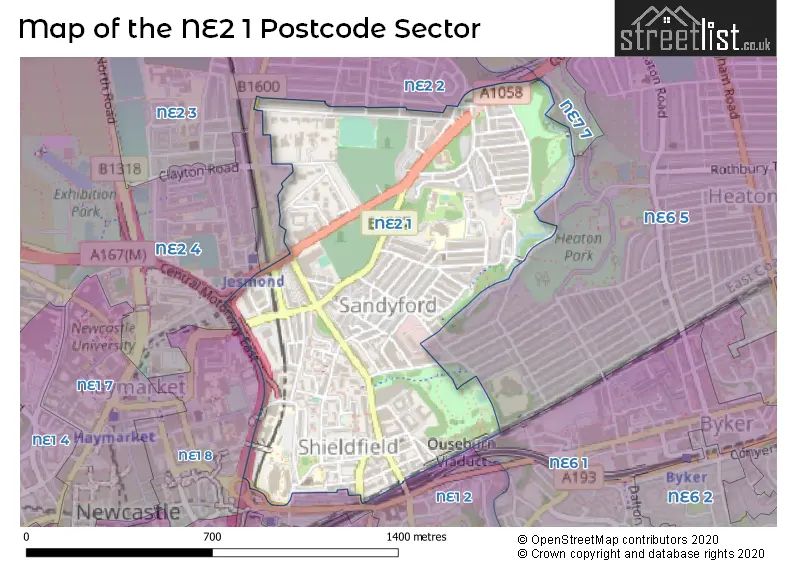
The NE2 1 Postcode shares a border with NE1 2 (NEWCASTLE UPON TYNE), NE2 2 (NEWCASTLE UPON TYNE, Jesmond), NE2 4 (NEWCASTLE UPON TYNE, Spital Tongues, Jesmond), NE1 8 (NEWCASTLE UPON TYNE), NE6 1 (NEWCASTLE UPON TYNE, Byker), NE6 5 (NEWCASTLE UPON TYNE, Heaton) and NE7 7 (NEWCASTLE UPON TYNE, High Heaton, Benton).
The sector is within the post town of NEWCASTLE UPON TYNE.
NE2 1 is a postcode sector within the NE2 postcode district which is within the NE Newcastle upon Tyne postcode area.
The Royal Mail delivery office for the NE2 1 postal sector is the Newcastle Upon Tyne City Delivery Office.
The area of the NE2 1 postcode sector is 0.52 square miles which is 1.34 square kilometres or 331.73 square acres.
Waterways within the NE2 1 postcode sector include the Ouseburn.

Map of the NE2 1 Postcode Sector
Explore the NE2 1 postcode sector by using our free interactive map.
| N | E | 2 | - | 1 | X | X |
| N | E | 2 | Space | 1 | Letter | Letter |
Official List of Streets
NEWCASTLE UPON TYNE (79 Streets)
Shieldfield (4 Streets)
Unofficial Streets or Alternative Spellings
NEWCASTLE UPON TYNE,
COAST ROADNEWCASTLE UPON TYNE
BACK NEW BRIDGE STREET BENTON BANK FARQUHAR STREET GOWAN TERRACE MANOR HOUSE ROAD NEW BRIDGE STREET OSBORNE ROAD OSBORNE VILLAS OUSEBURN ROAD SHORTRIDGE TERRACEShieldfield
SHIELDFIELD LANE ALBERT STREET ARCHBOLD TERRACE BERMONDSEY STREET CATTLE RUN CENTRAL MOTORWAY EAST FIELD CLOSE FORE STREET GLADSTONE PLACE INGHAM PLACE LOWERY PLACE NEW BRIDGE STREET ROUNDABOUT PRINCE ALBERT TERRACE ROCK TERRACE ROSEDALE TERRACE RUSSELL TERRACE THE WHITE BRIDGE WESLEY STREET WIGHAM CHAREWeather Forecast for NE2 1
Press Button to Show Forecast for Newcastle Upon Tyne
| Time Period | Icon | Description | Temperature | Rain Probability | Wind |
|---|---|---|---|---|---|
| 06:00 to 09:00 | Cloudy | 3.0°C (feels like 0.0°C) | 3.00% | WSW 7 mph | |
| 09:00 to 12:00 | Cloudy | 8.0°C (feels like 5.0°C) | 4.00% | WSW 9 mph | |
| 12:00 to 15:00 | Overcast | 9.0°C (feels like 6.0°C) | 50.00% | WSW 13 mph | |
| 15:00 to 18:00 | Light rain | 8.0°C (feels like 5.0°C) | 54.00% | WSW 13 mph | |
| 18:00 to 21:00 | Cloudy | 9.0°C (feels like 6.0°C) | 9.00% | W 16 mph | |
| 21:00 to 00:00 | Partly cloudy (night) | 9.0°C (feels like 5.0°C) | 3.00% | W 16 mph |
Press Button to Show Forecast for Newcastle Upon Tyne
| Time Period | Icon | Description | Temperature | Rain Probability | Wind |
|---|---|---|---|---|---|
| 00:00 to 03:00 | Cloudy | 8.0°C (feels like 5.0°C) | 6.00% | WNW 13 mph | |
| 03:00 to 06:00 | Cloudy | 7.0°C (feels like 4.0°C) | 8.00% | WNW 13 mph | |
| 06:00 to 09:00 | Overcast | 7.0°C (feels like 4.0°C) | 16.00% | NW 13 mph | |
| 09:00 to 12:00 | Overcast | 8.0°C (feels like 4.0°C) | 9.00% | NW 18 mph | |
| 12:00 to 15:00 | Cloudy | 9.0°C (feels like 6.0°C) | 6.00% | NNW 18 mph | |
| 15:00 to 18:00 | Cloudy | 9.0°C (feels like 5.0°C) | 5.00% | N 18 mph | |
| 18:00 to 21:00 | Partly cloudy (day) | 8.0°C (feels like 4.0°C) | 2.00% | N 16 mph | |
| 21:00 to 00:00 | Partly cloudy (night) | 6.0°C (feels like 2.0°C) | 2.00% | N 13 mph |
Press Button to Show Forecast for Newcastle Upon Tyne
| Time Period | Icon | Description | Temperature | Rain Probability | Wind |
|---|---|---|---|---|---|
| 00:00 to 03:00 | Cloudy | 5.0°C (feels like 1.0°C) | 5.00% | NNW 13 mph | |
| 03:00 to 06:00 | Overcast | 4.0°C (feels like 1.0°C) | 8.00% | NNW 11 mph | |
| 06:00 to 09:00 | Cloudy | 5.0°C (feels like 1.0°C) | 5.00% | NW 11 mph | |
| 09:00 to 12:00 | Cloudy | 7.0°C (feels like 4.0°C) | 5.00% | NNW 11 mph | |
| 12:00 to 15:00 | Cloudy | 8.0°C (feels like 6.0°C) | 5.00% | NNE 9 mph | |
| 15:00 to 18:00 | Cloudy | 9.0°C (feels like 7.0°C) | 5.00% | NE 9 mph | |
| 18:00 to 21:00 | Partly cloudy (day) | 8.0°C (feels like 6.0°C) | 2.00% | ENE 7 mph | |
| 21:00 to 00:00 | Cloudy | 7.0°C (feels like 6.0°C) | 5.00% | SSE 4 mph |
Press Button to Show Forecast for Newcastle Upon Tyne
| Time Period | Icon | Description | Temperature | Rain Probability | Wind |
|---|---|---|---|---|---|
| 00:00 to 03:00 | Cloudy | 7.0°C (feels like 5.0°C) | 7.00% | WSW 4 mph | |
| 03:00 to 06:00 | Cloudy | 7.0°C (feels like 5.0°C) | 7.00% | NW 4 mph | |
| 06:00 to 09:00 | Cloudy | 7.0°C (feels like 5.0°C) | 11.00% | NNW 7 mph | |
| 09:00 to 12:00 | Cloudy | 9.0°C (feels like 7.0°C) | 13.00% | NE 7 mph | |
| 12:00 to 15:00 | Overcast | 10.0°C (feels like 9.0°C) | 10.00% | ENE 7 mph | |
| 15:00 to 18:00 | Cloudy | 10.0°C (feels like 8.0°C) | 8.00% | E 9 mph | |
| 18:00 to 21:00 | Cloudy | 10.0°C (feels like 8.0°C) | 9.00% | E 9 mph | |
| 21:00 to 00:00 | Cloudy | 8.0°C (feels like 6.0°C) | 10.00% | ENE 7 mph |
Schools and Places of Education Within the NE2 1 Postcode Sector
Christ Church CofE Primary School
Voluntary aided school
Shieldfield Green, Newcastle upon Tyne, Tyne and Wear, NE2 1XA
Head: Ms Sandra Furno
Ofsted Rating: Good
Inspection: 2021-11-10 (890 days ago)
Website: Visit Christ Church CofE Primary School Website
Phone: 01912328054
Number of Pupils: 129
St Catherine's Catholic Primary School
Academy converter
Greystoke Gardens, Newcastle-upon-Tyne, Tyne and Wear, NE2 1PS
Head: Miss Lisa Hoey
Ofsted Rating: Good
Inspection: 2023-12-06 (134 days ago)
Website: Visit St Catherine's Catholic Primary School Website
Phone: 01912326803
Number of Pupils: 207
House Prices in the NE2 1 Postcode Sector
| Type of Property | 2018 Average | 2018 Sales | 2017 Average | 2017 Sales | 2016 Average | 2016 Sales | 2015 Average | 2015 Sales |
|---|---|---|---|---|---|---|---|---|
| Detached | £425,000 | 2 | £964,667 | 3 | £385,000 | 1 | £326,500 | 2 |
| Semi-Detached | £280,375 | 4 | £270,000 | 4 | £286,750 | 2 | £456,000 | 5 |
| Terraced | £285,869 | 26 | £291,712 | 29 | £291,102 | 38 | £296,199 | 23 |
| Flats | £154,489 | 73 | £160,929 | 85 | £158,694 | 79 | £150,308 | 82 |
Important Postcodes NE2 1 in the Postcode Sector
NE2 1AL is the postcode for Shieldfield Centre, 4-8 Clarence Walk
NE2 1AN is the postcode for Winn Studios, 17 Stoddart Street, Shieldfield, and Winn Studios, 17 Stoddart Street
NE2 1AW is the postcode for Stephenson Building, Stoddart Street
NE2 1DB is the postcode for Sandyford House, Archbold Terrace
NE2 1JP is the postcode for Newcastle Nuffield Hospital, Clayton Road
NE2 1PS is the postcode for St. Catherines RC Primary School, Greystoke Gardens
NE2 1QE is the postcode for NORTHUMBERLAND, TYNE AND WEAR NHS TRUST, Community Team Learning Disability, Benton House, 136 Sandyford Road, Cumbria, Northumberland, Tyne and Wear NHS Foundation Trust, Community Team Learning Disability, Benton House, and Community Team Learning Disability, Benton House, 136 Sandyford Road
NE2 1QH is the postcode for H M Revenue & Customs, Warwick House, Grantham Road
NE2 1TJ is the postcode for Mansion House, Fernwood Road, and Mansion House, Fernwood Road, Jesmond
NE2 1XA is the postcode for Christ Church C of E Primary School, Shieldfield Green, and Christ Church Ce Primary School, Shieldfield Green
NE2 1XE is the postcode for Glenamara House, Camden Street, Pandon Buildings, Camden Street, and Pandon Building, Camden Street
NE2 1XR is the postcode for Barker House, Shield Street
| The NE2 1 Sector is within these Local Authorities |
|
|---|---|
| The NE2 1 Sector is within these Counties |
|
| The NE2 1 Sector is within these Water Company Areas |
|