The NE23 1 postcode sector is within the county of Northumberland.
Did you know? According to the 2021 Census, the NE23 1 postcode sector is home to a bustling 4,570 residents!
Given that each sector allows for 400 unique postcode combinations. Letters C, I, K, M, O and V are not allowed in the last two letters of a postcode. With 146 postcodes already in use, this leaves 254 units available.
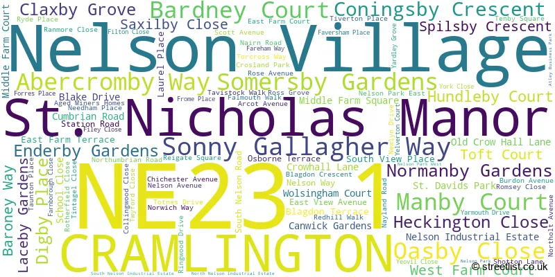
The largest settlement in the NE23 1 postal code is CRAMLINGTON followed by St. Nicholas Manor, and Nelson Village.
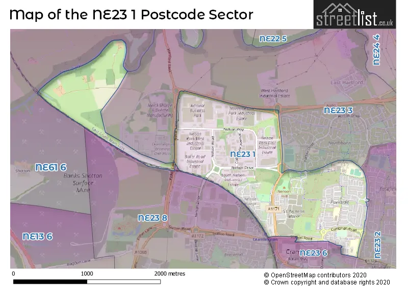
The NE23 1 Postcode shares a border with NE23 2 (CRAMLINGTON), NE61 6 (Pegswood, Stannington, St. Mary Park), NE23 3 (CRAMLINGTON, Hartford, Shankhouse), NE23 6 (CRAMLINGTON, Barley Meadows) and NE23 8 (CRAMLINGTON, The Fairways, West Meadows).
The sector is within the post town of CRAMLINGTON.
NE23 1 is a postcode sector within the NE23 postcode district which is within the NE Newcastle upon Tyne postcode area.
The Royal Mail delivery office for the NE23 1 postal sector is the Cramlington Delivery Office.
The area of the NE23 1 postcode sector is 1.53 square miles which is 3.96 square kilometres or 979.06 square acres.
Waterways within the NE23 1 postcode sector include the Blyth.

Map of the NE23 1 Postcode Sector
Explore the NE23 1 postcode sector by using our free interactive map.
| N | E | 2 | 3 | - | 1 | X | X |
| N | E | 2 | 3 | Space | 1 | Letter | Letter |
Official List of Streets
Nelson Village (10 Streets)
CRAMLINGTON (66 Streets)
St. Nicholas Manor (19 Streets)
Unofficial Streets or Alternative Spellings
CRAMLINGTON
HORTON DRIVE PARADISE ROW PORCHESTER DRIVE ARCOT COURT ATLEY WAY BAKER ROAD BROCKWELL ROUNDABOUT COLBOURNE AVENUE COLBOURNE CRESCENT CROSLAND WAY CROW HALL ROAD CROWHALL LANE ENTERPRISE COURT LOW MAIN PLACE MOORLAND WAY NELSON DRIVE NELSON PARK NETWORK CENTRE NELSON ROAD SUNNY SIDE TRAFALGAR COURT VILLAGE SQUARE WESTMORLAND WAYHigh Pit
VILLAGE ROADSeaton Burn
FISHER LANEWeather Forecast for NE23 1
Press Button to Show Forecast for Cramlington
| Time Period | Icon | Description | Temperature | Rain Probability | Wind |
|---|---|---|---|---|---|
| 00:00 to 03:00 | Cloudy | 3.0°C (feels like 1.0°C) | 5.00% | NNW 4 mph | |
| 03:00 to 06:00 | Cloudy | 2.0°C (feels like 0.0°C) | 13.00% | NW 4 mph | |
| 06:00 to 09:00 | Cloudy | 3.0°C (feels like 1.0°C) | 6.00% | NW 7 mph | |
| 09:00 to 12:00 | Cloudy | 6.0°C (feels like 3.0°C) | 8.00% | NNE 7 mph | |
| 12:00 to 15:00 | Cloudy | 7.0°C (feels like 5.0°C) | 9.00% | ENE 7 mph | |
| 15:00 to 18:00 | Cloudy | 8.0°C (feels like 6.0°C) | 9.00% | E 7 mph | |
| 18:00 to 21:00 | Sunny day | 7.0°C (feels like 5.0°C) | 5.00% | E 7 mph | |
| 21:00 to 00:00 | Clear night | 4.0°C (feels like 1.0°C) | 2.00% | SE 4 mph |
Press Button to Show Forecast for Cramlington
| Time Period | Icon | Description | Temperature | Rain Probability | Wind |
|---|---|---|---|---|---|
| 00:00 to 03:00 | Partly cloudy (night) | 2.0°C (feels like 0.0°C) | 2.00% | S 4 mph | |
| 03:00 to 06:00 | Partly cloudy (night) | 1.0°C (feels like -1.0°C) | 4.00% | S 4 mph | |
| 06:00 to 09:00 | Partly cloudy (day) | 3.0°C (feels like 1.0°C) | 6.00% | SSE 4 mph | |
| 09:00 to 12:00 | Cloudy | 7.0°C (feels like 6.0°C) | 11.00% | ESE 7 mph | |
| 12:00 to 15:00 | Cloudy | 9.0°C (feels like 6.0°C) | 10.00% | ESE 9 mph | |
| 15:00 to 18:00 | Partly cloudy (day) | 9.0°C (feels like 6.0°C) | 8.00% | E 11 mph | |
| 18:00 to 21:00 | Partly cloudy (day) | 8.0°C (feels like 5.0°C) | 9.00% | E 9 mph | |
| 21:00 to 00:00 | Cloudy | 6.0°C (feels like 3.0°C) | 13.00% | E 7 mph |
Press Button to Show Forecast for Cramlington
| Time Period | Icon | Description | Temperature | Rain Probability | Wind |
|---|---|---|---|---|---|
| 00:00 to 03:00 | Cloudy | 5.0°C (feels like 2.0°C) | 14.00% | ENE 7 mph | |
| 03:00 to 06:00 | Cloudy | 5.0°C (feels like 2.0°C) | 19.00% | NE 9 mph | |
| 06:00 to 09:00 | Overcast | 7.0°C (feels like 3.0°C) | 21.00% | NE 11 mph | |
| 09:00 to 12:00 | Light rain | 7.0°C (feels like 4.0°C) | 51.00% | NE 13 mph | |
| 12:00 to 15:00 | Light rain | 8.0°C (feels like 5.0°C) | 54.00% | NNE 13 mph | |
| 15:00 to 18:00 | Light rain | 9.0°C (feels like 6.0°C) | 55.00% | NNE 11 mph | |
| 18:00 to 21:00 | Light rain shower (day) | 9.0°C (feels like 7.0°C) | 39.00% | N 7 mph | |
| 21:00 to 00:00 | Clear night | 6.0°C (feels like 4.0°C) | 9.00% | ESE 7 mph |
Schools and Places of Education Within the NE23 1 Postcode Sector
Burnside Primary School
Community school
Northumbrian Road, Cramlington, Northumberland, NE23 1XZ
Head: Ms Jane Ramsay
Ofsted Rating: Good
Inspection: 2023-02-15 (436 days ago)
Website: Visit Burnside Primary School Website
Phone: 01670736052
Number of Pupils: 421
Cramlington Hillcrest School
Community special school
East View Avenue, Cramlington, Northumberland, NE23 1DY
Head: Mrs Andrea Mead
Ofsted Rating: Good
Inspection: 2022-12-01 (512 days ago)
Website: Visit Cramlington Hillcrest School Website
Phone: 01670713632
Number of Pupils: 114
Cramlington Shanklea Primary School
Community school
Nairn Road, Cramlington, Northumberland, NE23 1RQ
Head: Mrs Laura Ritson
Ofsted Rating: Good
Inspection: 2018-11-27 (1977 days ago)
Website: Visit Cramlington Shanklea Primary School Website
Phone: 01670715205
Number of Pupils: 317
House Prices in the NE23 1 Postcode Sector
| Type of Property | 2018 Average | 2018 Sales | 2017 Average | 2017 Sales | 2016 Average | 2016 Sales | 2015 Average | 2015 Sales |
|---|---|---|---|---|---|---|---|---|
| Detached | £254,110 | 44 | £220,583 | 6 | £219,050 | 19 | £253,195 | 27 |
| Semi-Detached | £152,982 | 60 | £150,850 | 20 | £130,775 | 18 | £146,848 | 28 |
| Terraced | £134,522 | 37 | £124,063 | 20 | £134,457 | 14 | £105,306 | 18 |
| Flats | £130,000 | 1 | £86,500 | 8 | £88,500 | 2 | £84,333 | 3 |
Important Postcodes NE23 1 in the Postcode Sector
NE23 1DJ is the postcode for Royal Mail, Cramlington Delivery Office, Crowhall Lane
NE23 1DY is the postcode for Hillcrest School, East View Avenue, and Hillcrest Day Special School, East View Avenue
NE23 1RQ is the postcode for Cramlington Shanklea Primary School, Nairn Road, Parkside Chase, and Shanklea Primary School, Nairn Road
NE23 1WB is the postcode for Northumberland Care Trust, Unit 43, Colbourne Crescent, Nelson Park
NE23 1WH is the postcode for Northumbria Police, Unit 13, Crow Hall Road
NE23 1XZ is the postcode for Burnside Primary School, Northumbrian Road, Brockwell Medical Group, 8 Northumbrian Road, Brockwell Centre, Burnside Primary School, Brockwell Centre, Northumbrian Road, Burnside Primary, Northumbrian Road, and EARLY YEARS BUILDING, Burnside Primary School, Brockwell Centre, Northumbrian Road
| The NE23 1 Sector is within these Local Authorities |
|
|---|---|
| The NE23 1 Sector is within these Counties |
|
| The NE23 1 Sector is within these Water Company Areas |
|