The NE25 postcode district is a postal district located in the NE Newcastle upon Tyne postcode area with a population of 30,385 residents according to the 2021 England and Wales Census.
The area of the NE25 postcode district is 7.53 square miles which is 19.51 square kilometres or 4,820.40 acres.
Currently, the NE25 district has about 671 postcode units spread across 3 geographic postcode sectors.
Given that each sector allows for 400 unique postcode combinations, the district has a capacity of 1,200 postcodes. With 671 postcodes already in use, this leaves 529 units available.
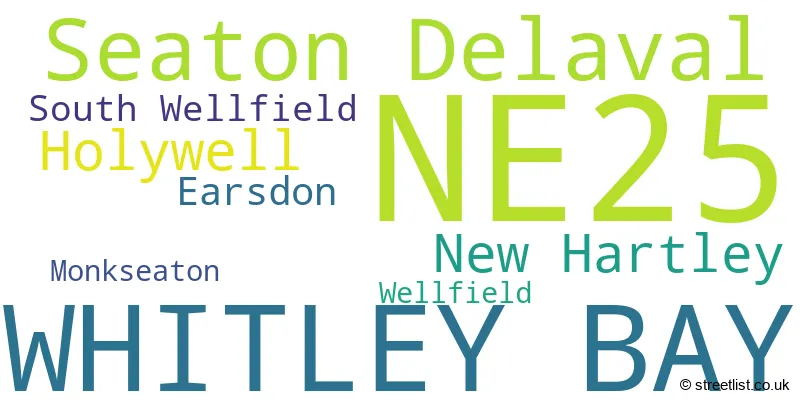
The largest settlement in the NE25 postal code is WHITLEY BAY followed by Seaton Delaval, and New Hartley.
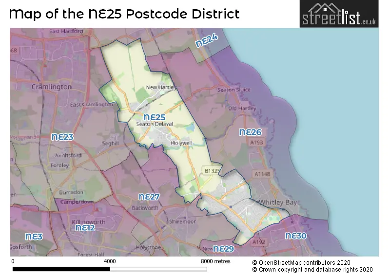
The NE25 Postcode shares a border with NE29 (NORTH SHIELDS), NE26 (WHITLEY BAY, Seaton Sluice, Monkseaton), NE24 (BLYTH, Cambois, Blyth Riverside Business Park), NE30 (NORTH SHIELDS, Tynemouth, Cullercoats), NE27 (Shiremoor, Backworth, West Allotment) and NE23 (CRAMLINGTON, Dudley, Seghill).
The primary settlement in the NE25 postcode district is Whitley Bay, located in the county of Tyne & Wear, England. Other significant settlements include Holywell, New Hartley, and Seaton Delaval, all of which are located in the county of Northumberland. The most significant post town with the highest number of postcodes in this district is Whitley Bay.
For the district NE25, we have data on 3 postcode sectors. Here's a breakdown: The sector NE25 0, covers Seaton Delaval and Holywell and New Hartley in Northumberland. The sector NE25 8, covers Whitley Bay in Tyne & Wear. The sector NE25 9, covers Whitley Bay in Tyne & Wear.

Map of the NE25 Postcode District
Explore the NE25 postcode district by using our free interactive map.
When it comes to local government, postal geography often disregards political borders. However, for a breakdown in the NE25 District: the district mostly encompasses the North Tyneside District (B) (426 postcodes), and finally, the Northumberland area (254 postcodes).
Recent House Sales in NE25
| Date | Price | Address |
|---|---|---|
| 23/10/2023 | £235,000 | Wallridge Drive, Holywell, Whitley Bay, NE25 0NL |
| 20/10/2023 | £10,000 | The Brambles, New Hartley, Whitley Bay, NE25 0RQ |
| 20/10/2023 | £122,500 | Western Avenue, Seaton Delaval, Whitley Bay, NE25 0EP |
| 10/10/2023 | £290,000 | Haddon Close, Whitley Bay, NE25 9QE |
| 25/09/2023 | £235,000 | Holly Avenue, Wellfield, Whitley Bay, NE25 9JH |
| 22/09/2023 | £270,000 | Burnside, South Wellfield, Whitley Bay, NE25 9HE |
| 22/09/2023 | £335,000 | Ashbrooke, Whitley Bay, NE25 8EG |
| 22/09/2023 | £127,500 | Birkdale, Whitley Bay, NE25 9LZ |
| 22/09/2023 | £160,000 | Bristol Street, New Hartley, Whitley Bay, NE25 0RG |
| 20/09/2023 | £92,000 | Wilson Court, Whitley Bay, NE25 8TR |
Weather Forecast for NE25
Press Button to Show Forecast for Whitley Bay
| Time Period | Icon | Description | Temperature | Rain Probability | Wind |
|---|---|---|---|---|---|
| 06:00 to 09:00 | Overcast | 5.0°C (feels like 1.0°C) | 8.00% | NNW 16 mph | |
| 09:00 to 12:00 | Cloudy | 6.0°C (feels like 2.0°C) | 8.00% | N 18 mph | |
| 12:00 to 15:00 | Cloudy | 7.0°C (feels like 3.0°C) | 7.00% | N 18 mph | |
| 15:00 to 18:00 | Cloudy | 7.0°C (feels like 3.0°C) | 4.00% | NNE 13 mph | |
| 18:00 to 21:00 | Partly cloudy (day) | 7.0°C (feels like 4.0°C) | 2.00% | ENE 9 mph | |
| 21:00 to 00:00 | Cloudy | 6.0°C (feels like 4.0°C) | 5.00% | SW 7 mph |
Press Button to Show Forecast for Whitley Bay
| Time Period | Icon | Description | Temperature | Rain Probability | Wind |
|---|---|---|---|---|---|
| 00:00 to 03:00 | Cloudy | 6.0°C (feels like 2.0°C) | 5.00% | W 11 mph | |
| 03:00 to 06:00 | Cloudy | 5.0°C (feels like 2.0°C) | 12.00% | NW 11 mph | |
| 06:00 to 09:00 | Cloudy | 5.0°C (feels like 2.0°C) | 7.00% | NW 11 mph | |
| 09:00 to 12:00 | Cloudy | 6.0°C (feels like 3.0°C) | 34.00% | NNW 13 mph | |
| 12:00 to 15:00 | Partly cloudy (day) | 7.0°C (feels like 4.0°C) | 3.00% | N 13 mph | |
| 15:00 to 18:00 | Partly cloudy (day) | 7.0°C (feels like 4.0°C) | 2.00% | NNE 11 mph | |
| 18:00 to 21:00 | Sunny day | 7.0°C (feels like 4.0°C) | 2.00% | NNE 9 mph | |
| 21:00 to 00:00 | Partly cloudy (night) | 5.0°C (feels like 3.0°C) | 1.00% | NE 7 mph |
Press Button to Show Forecast for Whitley Bay
| Time Period | Icon | Description | Temperature | Rain Probability | Wind |
|---|---|---|---|---|---|
| 00:00 to 03:00 | Partly cloudy (night) | 4.0°C (feels like 3.0°C) | 1.00% | NE 4 mph | |
| 03:00 to 06:00 | Cloudy | 4.0°C (feels like 2.0°C) | 4.00% | NNW 4 mph | |
| 06:00 to 09:00 | Cloudy | 4.0°C (feels like 2.0°C) | 5.00% | NNW 4 mph | |
| 09:00 to 12:00 | Cloudy | 7.0°C (feels like 5.0°C) | 7.00% | ENE 7 mph | |
| 12:00 to 15:00 | Cloudy | 7.0°C (feels like 5.0°C) | 8.00% | E 9 mph | |
| 15:00 to 18:00 | Cloudy | 8.0°C (feels like 5.0°C) | 7.00% | E 9 mph | |
| 18:00 to 21:00 | Cloudy | 7.0°C (feels like 5.0°C) | 7.00% | E 9 mph | |
| 21:00 to 00:00 | Cloudy | 6.0°C (feels like 3.0°C) | 7.00% | ESE 9 mph |
Press Button to Show Forecast for Whitley Bay
| Time Period | Icon | Description | Temperature | Rain Probability | Wind |
|---|---|---|---|---|---|
| 00:00 to 03:00 | Overcast | 6.0°C (feels like 3.0°C) | 24.00% | ESE 7 mph | |
| 03:00 to 06:00 | Cloudy | 5.0°C (feels like 3.0°C) | 8.00% | ESE 7 mph | |
| 06:00 to 09:00 | Cloudy | 6.0°C (feels like 4.0°C) | 8.00% | ESE 9 mph | |
| 09:00 to 12:00 | Overcast | 8.0°C (feels like 5.0°C) | 14.00% | ESE 11 mph | |
| 12:00 to 15:00 | Cloudy | 8.0°C (feels like 5.0°C) | 14.00% | E 13 mph | |
| 15:00 to 18:00 | Cloudy | 8.0°C (feels like 5.0°C) | 12.00% | E 16 mph | |
| 18:00 to 21:00 | Cloudy | 8.0°C (feels like 5.0°C) | 11.00% | E 13 mph | |
| 21:00 to 00:00 | Partly cloudy (night) | 7.0°C (feels like 4.0°C) | 9.00% | ENE 11 mph |
Where is the NE25 Postcode District?
The data indicates that the NE25 postcode district is located in Whitley Bay, a town in the North East of England. Whitley Bay is in close proximity to several nearby towns: Blyth to the North, Cramlington to the West, North Shields to the South East, Wallsend to the South, and Bedlington to the North West. Additionally, the NE25 district is approximately 252.5 miles away from the center of London.
The district is within the post town of WHITLEY BAY.
The sector has postcodes within the nation of England.
The NE25 Postcode District is covers the following regions.
- Northumberland - Northumberland and Tyne and Wear - North East (England)
- Tyneside - Northumberland and Tyne and Wear - North East (England)
| Postcode Sector | Delivery Office |
|---|---|
| NE25 0 | North Tyneside Delivery Office |
| NE25 8 | North Tyneside Delivery Office |
| NE25 9 | North Tyneside Delivery Office |
| N | E | 2 | 5 | - | X | X | X |
| N | E | 2 | 5 | Space | Numeric | Letter | Letter |
Current Monthly Rental Prices
| # Bedrooms | Min Price | Max Price | Avg Price |
|---|---|---|---|
| 1 | £525 | £700 | £580 |
| 2 | £675 | £1,100 | £870 |
| 4 | £1,300 | £2,200 | £1,750 |
Current House Prices
| # Bedrooms | Min Price | Max Price | Avg Price |
|---|---|---|---|
| 1 | £32,500 | £185,000 | £105,208 |
| 2 | £75,000 | £575,000 | £191,579 |
| 3 | £87,998 | £589,950 | £248,326 |
| 4 | £160,000 | £995,000 | £418,784 |
| 5 | £245,000 | £950,000 | £553,431 |
Estate Agents who Operate in the NE25 District
| Logo | Name | Brand Name | Address | Contact Number | Total Properties |
|---|---|---|---|---|---|
 | Whitley Bay | Signature | Head Office, 32 Beach Avenue, Tyne and Wear, NE26 1EA | 0191 625 1042 | 26 |
 | Seaton Delaval | M L Estates Ltd | 27 Avenue Road, Seaton Delaval, NE25 0DT | 0191 625 0966 | 22 |
 | WHITLEY BAY | J.G Sawyers & Sons | 17a Claremont Crescent, Whitley Bay, NE26 3HL | 0191 625 0110 | 21 |
 | Whitley Bay | Embleys Estate Agents | 1 Ilfracombe Gardens, Whitley Bay, NE26 3ND | 0191 252 2810 | 15 |
 | Whitley Bay | Pattinson Estate Agents | 189A Park View, Whitley Bay, NE26 3RD | 0191 625 0968 | 15 |
| Type of Property | 2018 Average | 2018 Sales | 2017 Average | 2017 Sales | 2016 Average | 2016 Sales | 2015 Average | 2015 Sales |
|---|---|---|---|---|---|---|---|---|
| Detached | £343,731 | 98 | £328,569 | 141 | £308,788 | 131 | £299,811 | 181 |
| Semi-Detached | £194,091 | 216 | £186,296 | 268 | £183,989 | 261 | £179,015 | 276 |
| Terraced | £182,811 | 134 | £178,120 | 148 | £167,511 | 135 | £160,286 | 151 |
| Flats | £111,543 | 68 | £100,549 | 70 | £89,030 | 78 | £97,210 | 80 |