The NE28 9 postcode sector is within the county of Tyne & Wear.
Did you know? According to the 2021 Census, the NE28 9 postcode sector is home to a bustling 14,643 residents!
Given that each sector allows for 400 unique postcode combinations. Letters C, I, K, M, O and V are not allowed in the last two letters of a postcode. With 281 postcodes already in use, this leaves 119 units available.
The NE28 9 postal code covers the settlement of WALLSEND.
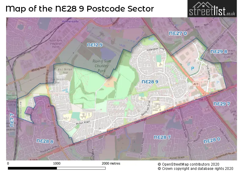
The NE28 9 Postcode shares a border with NE27 0 (Shiremoor, Backworth, West Allotment), NE28 0 (WALLSEND), NE28 7 (WALLSEND), NE29 7 (NORTH SHIELDS, Tyne Tunnel Trading Estate, Orion Business Park), NE29 8 (NORTH SHIELDS), NE12 9 (NEWCASTLE UPON TYNE, Forest Hall, Benton), NE28 8 (WALLSEND) and NE7 7 (NEWCASTLE UPON TYNE, High Heaton, Benton).
The sector is within the post town of WALLSEND.
NE28 9 is a postcode sector within the NE28 postcode district which is within the NE Newcastle upon Tyne postcode area.
The Royal Mail delivery office for the NE28 9 postal sector is the North Tyneside Delivery Office.
The area of the NE28 9 postcode sector is 1.83 square miles which is 4.74 square kilometres or 1,171.42 square acres.
The NE28 9 postcode sector is crossed by the A19 Major A road.

Map of the NE28 9 Postcode Sector
Explore the NE28 9 postcode sector by using our free interactive map.
| N | E | 2 | 8 | - | 9 | X | X |
| N | E | 2 | 8 | Space | 9 | Letter | Letter |
Official List of Streets
WALLSEND (171 Streets)
Unofficial Streets or Alternative Spellings
WALLSEND
RYEDALE STATION ROAD STATION ROAD NORTH WENSLEYDALE WILTSHIRE DRIVENORTH SHIELDS,
MIDDLE ENGINE LANENEWCASTLE UPON TYNE,
COAST ROADWeather Forecast for NE28 9
Press Button to Show Forecast for Willington (Tyne & Wear)
| Time Period | Icon | Description | Temperature | Rain Probability | Wind |
|---|---|---|---|---|---|
| 15:00 to 18:00 | Partly cloudy (day) | 7.0°C (feels like 4.0°C) | 3.00% | NNE 13 mph | |
| 18:00 to 21:00 | Partly cloudy (day) | 6.0°C (feels like 3.0°C) | 0.00% | NNE 9 mph | |
| 21:00 to 00:00 | Partly cloudy (night) | 5.0°C (feels like 2.0°C) | 35.00% | N 7 mph |
Press Button to Show Forecast for Willington (Tyne & Wear)
| Time Period | Icon | Description | Temperature | Rain Probability | Wind |
|---|---|---|---|---|---|
| 00:00 to 03:00 | Cloudy | 4.0°C (feels like 2.0°C) | 3.00% | NNW 4 mph | |
| 03:00 to 06:00 | Cloudy | 3.0°C (feels like 1.0°C) | 4.00% | NNW 4 mph | |
| 06:00 to 09:00 | Cloudy | 4.0°C (feels like 1.0°C) | 6.00% | NNW 7 mph | |
| 09:00 to 12:00 | Cloudy | 6.0°C (feels like 4.0°C) | 35.00% | NNE 7 mph | |
| 12:00 to 15:00 | Cloudy | 7.0°C (feels like 5.0°C) | 28.00% | ENE 7 mph | |
| 15:00 to 18:00 | Cloudy | 8.0°C (feels like 6.0°C) | 10.00% | E 7 mph | |
| 18:00 to 21:00 | Partly cloudy (day) | 7.0°C (feels like 5.0°C) | 4.00% | E 7 mph | |
| 21:00 to 00:00 | Partly cloudy (night) | 4.0°C (feels like 2.0°C) | 2.00% | SE 4 mph |
Press Button to Show Forecast for Willington (Tyne & Wear)
| Time Period | Icon | Description | Temperature | Rain Probability | Wind |
|---|---|---|---|---|---|
| 00:00 to 03:00 | Partly cloudy (night) | 3.0°C (feels like 1.0°C) | 2.00% | SSE 4 mph | |
| 03:00 to 06:00 | Partly cloudy (night) | 2.0°C (feels like 0.0°C) | 3.00% | SSW 4 mph | |
| 06:00 to 09:00 | Partly cloudy (day) | 3.0°C (feels like 1.0°C) | 5.00% | SSE 4 mph | |
| 09:00 to 12:00 | Partly cloudy (day) | 7.0°C (feels like 5.0°C) | 7.00% | ESE 7 mph | |
| 12:00 to 15:00 | Partly cloudy (day) | 9.0°C (feels like 6.0°C) | 8.00% | ESE 9 mph | |
| 15:00 to 18:00 | Sunny day | 9.0°C (feels like 6.0°C) | 6.00% | E 11 mph | |
| 18:00 to 21:00 | Partly cloudy (day) | 8.0°C (feels like 5.0°C) | 6.00% | E 11 mph | |
| 21:00 to 00:00 | Cloudy | 6.0°C (feels like 3.0°C) | 10.00% | E 9 mph |
Press Button to Show Forecast for Willington (Tyne & Wear)
| Time Period | Icon | Description | Temperature | Rain Probability | Wind |
|---|---|---|---|---|---|
| 00:00 to 03:00 | Cloudy | 5.0°C (feels like 3.0°C) | 14.00% | ENE 9 mph | |
| 03:00 to 06:00 | Cloudy | 6.0°C (feels like 3.0°C) | 14.00% | NE 9 mph | |
| 06:00 to 09:00 | Overcast | 7.0°C (feels like 3.0°C) | 17.00% | NE 13 mph | |
| 09:00 to 12:00 | Light rain | 7.0°C (feels like 4.0°C) | 50.00% | NE 13 mph | |
| 12:00 to 15:00 | Light rain | 8.0°C (feels like 4.0°C) | 50.00% | NNE 13 mph | |
| 15:00 to 18:00 | Light rain | 8.0°C (feels like 5.0°C) | 50.00% | NNE 13 mph | |
| 18:00 to 21:00 | Cloudy | 8.0°C (feels like 6.0°C) | 17.00% | N 9 mph | |
| 21:00 to 00:00 | Partly cloudy (night) | 6.0°C (feels like 3.0°C) | 11.00% | ESE 9 mph |
Schools and Places of Education Within the NE28 9 Postcode Sector
Beacon Hill School
Foundation special school
Rising Sun Cottages, Wallsend, Tyne and Wear, NE28 9JW
Head: Mrs Justina Terretta
Ofsted Rating: Good
Inspection: 2023-05-18 (343 days ago)
Website: Visit Beacon Hill School Website
Phone: 01916433000
Number of Pupils: 228
Wallsend Jubilee Primary School
Foundation school
Mullen Road, Wallsend, Tyne and Wear, NE28 9HA
Head: Mr David Harrison
Ofsted Rating: Good
Inspection: 2018-10-23 (2011 days ago)
Website: Visit Wallsend Jubilee Primary School Website
Phone: 01918141601
Number of Pupils: 370
House Prices in the NE28 9 Postcode Sector
| Type of Property | 2018 Average | 2018 Sales | 2017 Average | 2017 Sales | 2016 Average | 2016 Sales | 2015 Average | 2015 Sales |
|---|---|---|---|---|---|---|---|---|
| Detached | £236,856 | 79 | £217,717 | 87 | £210,651 | 36 | £233,206 | 53 |
| Semi-Detached | £150,471 | 61 | £153,038 | 84 | £131,893 | 71 | £127,321 | 77 |
| Terraced | £116,725 | 110 | £122,912 | 119 | £109,464 | 62 | £109,478 | 68 |
| Flats | £86,027 | 37 | £75,300 | 33 | £72,962 | 21 | £74,115 | 20 |
Important Postcodes NE28 9 in the Postcode Sector
NE28 9DH is the postcode for Battle Hill Community Primary School, Berwick Drive
NE28 9DX is the postcode for Battle Hill Health Centre, Belmont Close, Battle Hill
NE28 9EF is the postcode for North Tyneside Council, Battle Hill Branch Library, Berwick Drive
NE28 9HA is the postcode for Wallsend Jubilee Primary School, Mullen Road
NE28 9JW is the postcode for Beacon Hill School and Specialist College for Business and Enterprise, Rising Sun Cottages, and St Bernadettes RC VA Primary School, Rising Sun Cottages
NE28 9NL is the postcode for Ignite Building, Tyne Metropolitan College, Block E, Tyne Metropolitan College, Embleton Avenue, Block E, Tyne Metropolitan College, Block A, Tyne Metropolitan College, Block D, Tyne Metropolitan College, Embleton Avenue, Block B, Tyne Metropolitan College, Block G, Tyne Metropolitan College, Block C, Tyne Metropolitan College, Block F, Tyne Metropolitan College, Embleton Avenue, Block A, Tyne Metropolitan College, Embleton Avenue, Block C, Tyne Metropolitan College, Embleton Avenue, Block F, Tyne Metropolitan College, Block D, Tyne Metropolitan College, and Sports Hall, Tyne Metropolitan College
NE28 9NT is the postcode for North Tyneside Area Command Headquarters, Middle Engine Lane, and Northumbria Police, North Tyneside Area Command Headquarters, Middle Engine Lane
NE28 9RJ is the postcode for Battle Hill Multi-Use Centre, Bray Close
NE28 9RT is the postcode for Handrian Park PRU, Addington Drive, North Tyneside Coucil, Hadrian Education Centre, Addington Drive, and Hadrian Park Primary School, Addington Drive
| The NE28 9 Sector is within these Local Authorities |
|
|---|---|
| The NE28 9 Sector is within these Counties |
|
| The NE28 9 Sector is within these Water Company Areas |
|