The NE33 5 postcode sector is within the county of Tyne & Wear.
Did you know? According to the 2021 Census, the NE33 5 postcode sector is home to a bustling 4,484 residents!
Given that each sector allows for 400 unique postcode combinations. Letters C, I, K, M, O and V are not allowed in the last two letters of a postcode. With 124 postcodes already in use, this leaves 276 units available.
The NE33 5 postal code covers the settlement of SOUTH SHIELDS.
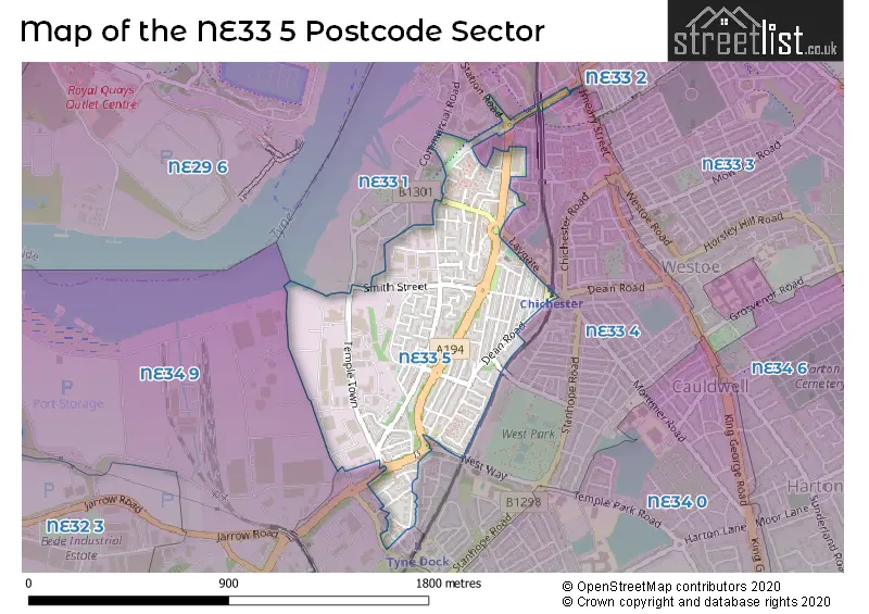
The NE33 5 Postcode shares a border with NE33 1 (SOUTH SHIELDS), NE33 4 (SOUTH SHIELDS), NE34 9 (SOUTH SHIELDS), NE33 2 (SOUTH SHIELDS) and NE34 0 (SOUTH SHIELDS).
The sector is within the post town of SOUTH SHIELDS.
NE33 5 is a postcode sector within the NE33 postcode district which is within the NE Newcastle upon Tyne postcode area.
The Royal Mail delivery office for the NE33 5 postal sector is the South Shields Delivery Office.
The area of the NE33 5 postcode sector is 0.40 square miles which is 1.05 square kilometres or 258.67 square acres.

Map of the NE33 5 Postcode Sector
Explore the NE33 5 postcode sector by using our free interactive map.
| N | E | 3 | 3 | - | 5 | X | X |
| N | E | 3 | 3 | Space | 5 | Letter | Letter |
Official List of Streets
SOUTH SHIELDS (73 Streets)
Unofficial Streets or Alternative Spellings
SOUTH SHIELDS
BOLDON LANE CLAYPATH LANE CORSTORPHINE TOWN GARDEN LANE HENRY ROBSON WAY HUDSON STREET PORTBERRY STREET REKENDYKE LANE STATION ROAD THE CAPTAINS ROW VICTORIA ROAD WEST PARK ROAD WEST WAY WESTOE ROAD GARWOOD STREET CLOSE HOLMAN COURT LAYGATE RO LAYGATE ROUNDABOUT OLEARY COURT SAINT JUDES TERRACE SAINT MARKS WAY SMITH STREET ST MARKS WAY TEMPLE STREET WEST TEMPLE TOWN WILSON STREETWeather Forecast for NE33 5
Press Button to Show Forecast for South Shields
| Time Period | Icon | Description | Temperature | Rain Probability | Wind |
|---|---|---|---|---|---|
| 21:00 to 00:00 | Cloudy | 5.0°C (feels like 3.0°C) | 4.00% | NNE 7 mph |
Press Button to Show Forecast for South Shields
| Time Period | Icon | Description | Temperature | Rain Probability | Wind |
|---|---|---|---|---|---|
| 00:00 to 03:00 | Cloudy | 5.0°C (feels like 3.0°C) | 3.00% | N 4 mph | |
| 03:00 to 06:00 | Partly cloudy (night) | 4.0°C (feels like 1.0°C) | 1.00% | NW 7 mph | |
| 06:00 to 09:00 | Cloudy | 4.0°C (feels like 2.0°C) | 5.00% | NNW 7 mph | |
| 09:00 to 12:00 | Cloudy | 6.0°C (feels like 4.0°C) | 35.00% | NNE 9 mph | |
| 12:00 to 15:00 | Cloudy | 8.0°C (feels like 6.0°C) | 11.00% | ENE 7 mph | |
| 15:00 to 18:00 | Cloudy | 8.0°C (feels like 6.0°C) | 10.00% | E 7 mph | |
| 18:00 to 21:00 | Sunny day | 7.0°C (feels like 5.0°C) | 4.00% | E 7 mph | |
| 21:00 to 00:00 | Clear night | 4.0°C (feels like 2.0°C) | 2.00% | SE 7 mph |
Press Button to Show Forecast for South Shields
| Time Period | Icon | Description | Temperature | Rain Probability | Wind |
|---|---|---|---|---|---|
| 00:00 to 03:00 | Partly cloudy (night) | 3.0°C (feels like 1.0°C) | 2.00% | SSE 4 mph | |
| 03:00 to 06:00 | Clear night | 2.0°C (feels like 0.0°C) | 3.00% | SSW 4 mph | |
| 06:00 to 09:00 | Partly cloudy (day) | 4.0°C (feels like 2.0°C) | 5.00% | SSE 4 mph | |
| 09:00 to 12:00 | Partly cloudy (day) | 8.0°C (feels like 6.0°C) | 7.00% | ESE 7 mph | |
| 12:00 to 15:00 | Partly cloudy (day) | 9.0°C (feels like 7.0°C) | 8.00% | ESE 9 mph | |
| 15:00 to 18:00 | Sunny day | 9.0°C (feels like 6.0°C) | 6.00% | E 11 mph | |
| 18:00 to 21:00 | Partly cloudy (day) | 8.0°C (feels like 5.0°C) | 6.00% | E 11 mph | |
| 21:00 to 00:00 | Cloudy | 6.0°C (feels like 4.0°C) | 10.00% | E 9 mph |
Press Button to Show Forecast for South Shields
| Time Period | Icon | Description | Temperature | Rain Probability | Wind |
|---|---|---|---|---|---|
| 00:00 to 03:00 | Cloudy | 6.0°C (feels like 3.0°C) | 14.00% | NE 9 mph | |
| 03:00 to 06:00 | Cloudy | 6.0°C (feels like 3.0°C) | 14.00% | NE 9 mph | |
| 06:00 to 09:00 | Overcast | 7.0°C (feels like 4.0°C) | 17.00% | NNE 13 mph | |
| 09:00 to 12:00 | Light rain | 8.0°C (feels like 4.0°C) | 50.00% | NNE 16 mph | |
| 12:00 to 15:00 | Light rain | 8.0°C (feels like 5.0°C) | 52.00% | NNE 16 mph | |
| 15:00 to 18:00 | Light rain | 8.0°C (feels like 5.0°C) | 51.00% | NNE 13 mph | |
| 18:00 to 21:00 | Cloudy | 9.0°C (feels like 7.0°C) | 17.00% | N 9 mph | |
| 21:00 to 00:00 | Partly cloudy (night) | 6.0°C (feels like 4.0°C) | 11.00% | ESE 9 mph |
House Prices in the NE33 5 Postcode Sector
| Type of Property | 2018 Average | 2018 Sales | 2017 Average | 2017 Sales | 2016 Average | 2016 Sales | 2015 Average | 2015 Sales |
|---|---|---|---|---|---|---|---|---|
| Detached | £222,500 | 2 | £201,249 | 4 | £220,000 | 2 | £155,308 | 8 |
| Semi-Detached | £146,310 | 8 | £151,184 | 8 | £125,354 | 14 | £139,364 | 17 |
| Terraced | £126,223 | 38 | £116,116 | 45 | £118,896 | 26 | £96,399 | 14 |
| Flats | £71,980 | 29 | £57,497 | 24 | £45,400 | 15 | £40,819 | 16 |
Important Postcodes NE33 5 in the Postcode Sector
NE33 5AS is the postcode for Tyne Dock Community Centre, The Captains Row
NE33 5DU is the postcode for St. George Medical Centre, New George Street
NE33 5RT is the postcode for Laygate Family Centre, 38 Laygate Place, and Laygate Family Centre, Laygate Place
| The NE33 5 Sector is within these Local Authorities |
|
|---|---|
| The NE33 5 Sector is within these Counties |
|
| The NE33 5 Sector is within these Water Company Areas |
|