The NE34 9 postcode sector is within the county of Tyne & Wear.
Did you know? According to the 2021 Census, the NE34 9 postcode sector is home to a bustling 11,234 residents!
Given that each sector allows for 400 unique postcode combinations. Letters C, I, K, M, O and V are not allowed in the last two letters of a postcode. With 232 postcodes already in use, this leaves 168 units available.
The NE34 9 postal code covers the settlement of SOUTH SHIELDS.
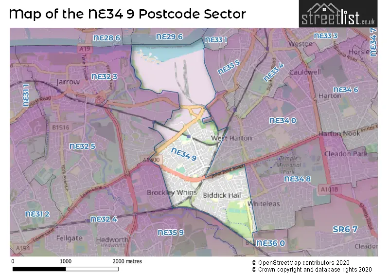
The NE34 9 Postcode shares a border with NE32 3 (JARROW), NE32 4 (JARROW), NE33 5 (SOUTH SHIELDS), NE34 8 (SOUTH SHIELDS), NE35 9 (BOLDON COLLIERY, Boldon Business Park), NE34 0 (SOUTH SHIELDS) and NE36 0 (EAST BOLDON, West Boldon).
The sector is within the post town of SOUTH SHIELDS.
NE34 9 is a postcode sector within the NE34 postcode district which is within the NE Newcastle upon Tyne postcode area.
The Royal Mail delivery office for the NE34 9 postal sector is the South Shields Delivery Office.
The area of the NE34 9 postcode sector is 1.46 square miles which is 3.78 square kilometres or 933.08 square acres.
Waterways within the NE34 9 postcode sector include the Don.

Map of the NE34 9 Postcode Sector
Explore the NE34 9 postcode sector by using our free interactive map.
| N | E | 3 | 4 | - | 9 | X | X |
| N | E | 3 | 4 | Space | 9 | Letter | Letter |
Official List of Streets
SOUTH SHIELDS (136 Streets)
Unofficial Streets or Alternative Spellings
SOUTH SHIELDS
GREEN LANEMiddlefields Industrial Estate
THROCKLEY WAYJARROW
BEDESWAY HADRIAN ROADJARROW,
PERTH AVENUE SHAFTESBURY AVENUEWeather Forecast for NE34 9
Press Button to Show Forecast for Jarrow
| Time Period | Icon | Description | Temperature | Rain Probability | Wind |
|---|---|---|---|---|---|
| 09:00 to 12:00 | Light rain shower (day) | 6.0°C (feels like 3.0°C) | 37.00% | N 11 mph | |
| 12:00 to 15:00 | Sunny day | 7.0°C (feels like 4.0°C) | 32.00% | N 11 mph | |
| 15:00 to 18:00 | Partly cloudy (day) | 8.0°C (feels like 4.0°C) | 2.00% | NNE 11 mph | |
| 18:00 to 21:00 | Sunny day | 7.0°C (feels like 4.0°C) | 0.00% | NNE 9 mph | |
| 21:00 to 00:00 | Cloudy | 5.0°C (feels like 3.0°C) | 12.00% | N 7 mph |
Press Button to Show Forecast for Jarrow
| Time Period | Icon | Description | Temperature | Rain Probability | Wind |
|---|---|---|---|---|---|
| 00:00 to 03:00 | Cloudy | 4.0°C (feels like 2.0°C) | 7.00% | NNW 4 mph | |
| 03:00 to 06:00 | Partly cloudy (night) | 3.0°C (feels like 1.0°C) | 2.00% | NNW 4 mph | |
| 06:00 to 09:00 | Cloudy | 4.0°C (feels like 2.0°C) | 5.00% | NNW 7 mph | |
| 09:00 to 12:00 | Partly cloudy (day) | 6.0°C (feels like 4.0°C) | 35.00% | NNE 7 mph | |
| 12:00 to 15:00 | Cloudy | 8.0°C (feels like 6.0°C) | 11.00% | ENE 7 mph | |
| 15:00 to 18:00 | Cloudy | 8.0°C (feels like 6.0°C) | 10.00% | E 7 mph | |
| 18:00 to 21:00 | Sunny day | 7.0°C (feels like 5.0°C) | 4.00% | E 7 mph | |
| 21:00 to 00:00 | Clear night | 4.0°C (feels like 2.0°C) | 2.00% | SE 4 mph |
Press Button to Show Forecast for Jarrow
| Time Period | Icon | Description | Temperature | Rain Probability | Wind |
|---|---|---|---|---|---|
| 00:00 to 03:00 | Partly cloudy (night) | 3.0°C (feels like 1.0°C) | 2.00% | S 4 mph | |
| 03:00 to 06:00 | Clear night | 2.0°C (feels like 0.0°C) | 3.00% | SSW 4 mph | |
| 06:00 to 09:00 | Partly cloudy (day) | 4.0°C (feels like 2.0°C) | 5.00% | SSE 4 mph | |
| 09:00 to 12:00 | Partly cloudy (day) | 8.0°C (feels like 6.0°C) | 7.00% | ESE 7 mph | |
| 12:00 to 15:00 | Partly cloudy (day) | 9.0°C (feels like 7.0°C) | 8.00% | ESE 9 mph | |
| 15:00 to 18:00 | Sunny day | 9.0°C (feels like 6.0°C) | 6.00% | E 11 mph | |
| 18:00 to 21:00 | Partly cloudy (day) | 8.0°C (feels like 5.0°C) | 6.00% | E 11 mph | |
| 21:00 to 00:00 | Cloudy | 6.0°C (feels like 4.0°C) | 10.00% | E 9 mph |
Press Button to Show Forecast for Jarrow
| Time Period | Icon | Description | Temperature | Rain Probability | Wind |
|---|---|---|---|---|---|
| 00:00 to 03:00 | Cloudy | 5.0°C (feels like 3.0°C) | 14.00% | ENE 9 mph | |
| 03:00 to 06:00 | Cloudy | 6.0°C (feels like 3.0°C) | 14.00% | NE 9 mph | |
| 06:00 to 09:00 | Overcast | 7.0°C (feels like 4.0°C) | 17.00% | NE 13 mph | |
| 09:00 to 12:00 | Light rain | 8.0°C (feels like 4.0°C) | 50.00% | NE 16 mph | |
| 12:00 to 15:00 | Light rain | 8.0°C (feels like 5.0°C) | 52.00% | NNE 16 mph | |
| 15:00 to 18:00 | Light rain | 8.0°C (feels like 5.0°C) | 50.00% | NNE 13 mph | |
| 18:00 to 21:00 | Cloudy | 9.0°C (feels like 7.0°C) | 17.00% | N 9 mph | |
| 21:00 to 00:00 | Partly cloudy (night) | 6.0°C (feels like 4.0°C) | 11.00% | ESE 9 mph |
Schools and Places of Education Within the NE34 9 Postcode Sector
Biddick Hall Infants' School
Community school
Galsworthy Road, South Shields, Tyne and Wear, NE34 9JD
Head: Mrs Andrea Willis
Ofsted Rating: Good
Inspection: 2022-11-04 (538 days ago)
Website: Visit Biddick Hall Infants' School Website
Phone: 01919330830
Number of Pupils: 238
Biddick Hall Junior School
Community school
Chesterton Road, South Shields, Tyne and Wear, NE34 9SP
Head: Mrs M Collinson
Ofsted Rating: Good
Inspection: 2023-03-09 (413 days ago)
Website: Visit Biddick Hall Junior School Website
Phone: 01915362186
Number of Pupils: 205
Lord Blyton Primary School
Community school
Blyton Avenue, South Shields, Tyne and Wear, NE34 9BN
Head: Headteacher Jo Atherton
Ofsted Rating: Requires improvement
Inspection: 2023-11-08 (169 days ago)
Website: Visit Lord Blyton Primary School Website
Phone: 07903725594
Number of Pupils: 251
Monkton Academy
Academy converter
Dame Flora Robson Avenue, South Shields, Tyne and Wear, NE34 9RD
Head: Mr Steve Bowler
Ofsted Rating: Good
Inspection: 2019-05-01 (1821 days ago)
Website: Visit Monkton Academy Website
Phone: 01914240200
Number of Pupils: 176
Monkton Infants' School
Academy converter
St Simon Street, South Shields, Tyne and Wear, NE34 9SD
Head: Mrs Clare Askwith
Ofsted Rating: Good
Inspection: 2019-11-27 (1611 days ago)
Website: Visit Monkton Infants' School Website
Phone: 01914561917
Number of Pupils: 165
House Prices in the NE34 9 Postcode Sector
| Type of Property | 2018 Average | 2018 Sales | 2017 Average | 2017 Sales | 2016 Average | 2016 Sales | 2015 Average | 2015 Sales |
|---|---|---|---|---|---|---|---|---|
| Detached | £215,500 | 8 | £197,704 | 12 | £180,873 | 24 | £171,357 | 30 |
| Semi-Detached | £121,932 | 31 | £118,508 | 31 | £112,391 | 37 | £124,071 | 51 |
| Terraced | £80,978 | 71 | £84,688 | 73 | £89,132 | 86 | £80,522 | 79 |
| Flats | £0 | 0 | £35,500 | 1 | £32,500 | 2 | £29,000 | 1 |
Important Postcodes NE34 9 in the Postcode Sector
NE34 9BN is the postcode for Lord Blyton Primary School, Blyton Avenue
NE34 9DT is the postcode for South Tyneside Metropolitan Borough Council, Crematorium, John Reid Road
NE34 9JD is the postcode for Biddick Hall County Infant School, Galsworthy Road
NE34 9QS is the postcode for Monkton Nursery Unit, Bainbridge Avenue
NE34 9RD is the postcode for Monkton Junior School, Dame Flora Robson Avenue
NE34 9SD is the postcode for Monkton Infant School, St Simon Street, Monkton County Infant School, St. Simon Street, and Simonside Outdoor Adventure, St. Simon Street
NE34 9SP is the postcode for Biddick Hall County Junior School, Chesterton Road
NE34 9UG is the postcode for Chuter Ede Education Centre, Galsworthy Road
| The NE34 9 Sector is within these Local Authorities |
|
|---|---|
| The NE34 9 Sector is within these Counties |
|
| The NE34 9 Sector is within these Water Company Areas |
|