The NE38 0 postcode sector is within the county of Tyne & Wear.
Did you know? According to the 2021 Census, the NE38 0 postcode sector is home to a bustling 8,726 residents!
Given that each sector allows for 400 unique postcode combinations. Letters C, I, K, M, O and V are not allowed in the last two letters of a postcode. With 141 postcodes already in use, this leaves 259 units available.
The largest settlements in the NE38 0 postal code are WASHINGTON and Crowther.
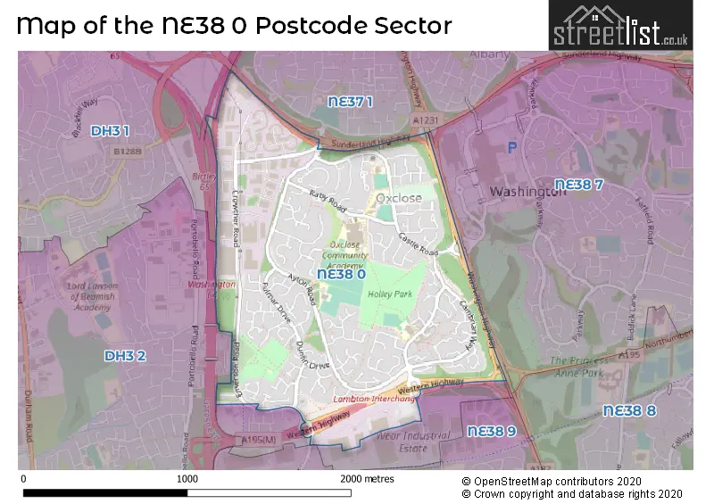
The NE38 0 Postcode shares a border with NE38 7 (WASHINGTON), NE38 9 (WASHINGTON, High Rickleton, Picktree), NE37 1 (WASHINGTON, Armstrong), DH3 1 (Birtley) and DH3 2 (Birtley, CHESTER LE STREET).
The sector is within the post town of WASHINGTON.
NE38 0 is a postcode sector within the NE38 postcode district which is within the NE Newcastle upon Tyne postcode area.
The Royal Mail delivery office for the NE38 0 postal sector is the Washington Delivery Office.
The area of the NE38 0 postcode sector is 1.03 square miles which is 2.67 square kilometres or 659.31 square acres.
The NE38 0 postcode sector is crossed by the A194M Major A road.


Map of the NE38 0 Postcode Sector
Explore the NE38 0 postcode sector by using our free interactive map.
| N | E | 3 | 8 | - | 0 | X | X |
| N | E | 3 | 8 | Space | 0 | Letter | Letter |
Official List of Streets
WASHINGTON (103 Streets)
Crowther (4 Streets)
Unofficial Streets or Alternative Spellings
Weather Forecast for NE38 0
Press Button to Show Forecast for Birtley
| Time Period | Icon | Description | Temperature | Rain Probability | Wind |
|---|---|---|---|---|---|
| 12:00 to 15:00 | Cloudy | 7.0°C (feels like 4.0°C) | 34.00% | N 11 mph | |
| 15:00 to 18:00 | Cloudy | 8.0°C (feels like 5.0°C) | 12.00% | NNE 11 mph | |
| 18:00 to 21:00 | Partly cloudy (day) | 7.0°C (feels like 4.0°C) | 1.00% | NNE 9 mph | |
| 21:00 to 00:00 | Cloudy | 5.0°C (feels like 3.0°C) | 6.00% | NNE 4 mph |
Press Button to Show Forecast for Birtley
| Time Period | Icon | Description | Temperature | Rain Probability | Wind |
|---|---|---|---|---|---|
| 00:00 to 03:00 | Cloudy | 4.0°C (feels like 2.0°C) | 5.00% | NNW 4 mph | |
| 03:00 to 06:00 | Cloudy | 3.0°C (feels like 1.0°C) | 4.00% | NW 4 mph | |
| 06:00 to 09:00 | Cloudy | 4.0°C (feels like 2.0°C) | 6.00% | NNW 4 mph | |
| 09:00 to 12:00 | Overcast | 6.0°C (feels like 4.0°C) | 11.00% | NNE 7 mph | |
| 12:00 to 15:00 | Overcast | 7.0°C (feels like 6.0°C) | 10.00% | ENE 7 mph | |
| 15:00 to 18:00 | Overcast | 8.0°C (feels like 6.0°C) | 10.00% | ENE 7 mph | |
| 18:00 to 21:00 | Partly cloudy (day) | 7.0°C (feels like 5.0°C) | 6.00% | E 7 mph | |
| 21:00 to 00:00 | Partly cloudy (night) | 5.0°C (feels like 4.0°C) | 2.00% | ESE 4 mph |
Press Button to Show Forecast for Birtley
| Time Period | Icon | Description | Temperature | Rain Probability | Wind |
|---|---|---|---|---|---|
| 00:00 to 03:00 | Partly cloudy (night) | 4.0°C (feels like 2.0°C) | 3.00% | SE 4 mph | |
| 03:00 to 06:00 | Partly cloudy (night) | 3.0°C (feels like 1.0°C) | 4.00% | SW 4 mph | |
| 06:00 to 09:00 | Partly cloudy (day) | 4.0°C (feels like 3.0°C) | 6.00% | E 4 mph | |
| 09:00 to 12:00 | Cloudy | 8.0°C (feels like 6.0°C) | 12.00% | E 7 mph | |
| 12:00 to 15:00 | Cloudy | 9.0°C (feels like 6.0°C) | 11.00% | E 9 mph | |
| 15:00 to 18:00 | Cloudy | 9.0°C (feels like 6.0°C) | 11.00% | E 11 mph | |
| 18:00 to 21:00 | Cloudy | 8.0°C (feels like 6.0°C) | 12.00% | E 9 mph | |
| 21:00 to 00:00 | Partly cloudy (night) | 7.0°C (feels like 4.0°C) | 11.00% | ENE 9 mph |
Press Button to Show Forecast for Birtley
| Time Period | Icon | Description | Temperature | Rain Probability | Wind |
|---|---|---|---|---|---|
| 00:00 to 03:00 | Cloudy | 6.0°C (feels like 4.0°C) | 16.00% | ENE 9 mph | |
| 03:00 to 06:00 | Cloudy | 6.0°C (feels like 4.0°C) | 17.00% | NE 9 mph | |
| 06:00 to 09:00 | Overcast | 7.0°C (feels like 4.0°C) | 23.00% | NE 11 mph | |
| 09:00 to 12:00 | Light rain | 8.0°C (feels like 5.0°C) | 51.00% | NE 11 mph | |
| 12:00 to 15:00 | Light rain | 10.0°C (feels like 7.0°C) | 55.00% | NE 11 mph | |
| 15:00 to 18:00 | Light rain | 10.0°C (feels like 8.0°C) | 56.00% | NNE 11 mph | |
| 18:00 to 21:00 | Heavy rain | 10.0°C (feels like 8.0°C) | 70.00% | NNE 9 mph | |
| 21:00 to 00:00 | Partly cloudy (night) | 8.0°C (feels like 6.0°C) | 11.00% | ENE 9 mph |
Schools and Places of Education Within the NE38 0 Postcode Sector
Holley Park Academy
Academy converter
Ayton Road, Washington, Tyne and Wear, NE38 0LR
Head: Mrs Lisa Curtis
Ofsted Rating: Good
Inspection: 2018-12-18 (1955 days ago)
Website: Visit Holley Park Academy Website
Phone: 01914170303
Number of Pupils: 258
Lambton Primary School
Community school
Caradoc Close, Washington, Tyne and Wear, NE38 0PL
Head: Mrs Amanda Defty
Ofsted Rating: Good
Inspection: 2019-04-03 (1849 days ago)
Website: Visit Lambton Primary School Website
Phone: 01914813993
Number of Pupils: 209
Oxclose Community Academy
Academy converter
Dilston Close, Washington, Tyne and Wear, NE38 0LN
Head: Mrs Paula Hegarty
Ofsted Rating: Good
Inspection: 2020-01-15 (1562 days ago)
Website: Visit Oxclose Community Academy Website
Phone: 01914195120
Number of Pupils: 1122
Oxclose Nursery School
Local authority nursery school
Brancepeth Road, Washington, Tyne and Wear, NE38 0LA
Head: Miss Ruth Brown
Ofsted Rating: Outstanding
Inspection: 2019-02-06 (1905 days ago)
Website: Visit Oxclose Nursery School Website
Phone: 01914166767
Number of Pupils: 73
Oxclose Primary Academy
Academy sponsor led
Brancepeth Road, Washington, Tyne and Wear, NE38 0LA
Head: Mrs A E Bolam
Ofsted Rating: Good
Inspection: 2022-04-06 (750 days ago)
Website: Visit Oxclose Primary Academy Website
Phone: 01915008790
Number of Pupils: 196
House Prices in the NE38 0 Postcode Sector
| Type of Property | 2018 Average | 2018 Sales | 2017 Average | 2017 Sales | 2016 Average | 2016 Sales | 2015 Average | 2015 Sales |
|---|---|---|---|---|---|---|---|---|
| Detached | £207,730 | 22 | £206,748 | 24 | £223,225 | 26 | £212,929 | 41 |
| Semi-Detached | £124,900 | 32 | £129,095 | 42 | £126,451 | 37 | £134,827 | 43 |
| Terraced | £101,570 | 41 | £101,444 | 49 | £97,374 | 41 | £97,142 | 52 |
| Flats | £54,907 | 15 | £69,125 | 8 | £64,533 | 15 | £58,364 | 11 |
Important Postcodes NE38 0 in the Postcode Sector
NE38 0DA is the postcode for Washington Multi Purpose Centre, Ayton Road, Oxclose Village, and Washington Multi Purpose, Ayton Road, Oxclose Village
NE38 0HL is the postcode for St. John Boste RC Primary School, Castle Road
NE38 0LA is the postcode for Oxclose Nursery School, Brancepeth Road, and Oxclose Primary Academy, Brancepeth Road
NE38 0LN is the postcode for Oxclose Community Academy, Dilston Close
NE38 0LR is the postcode for Holley Park Academy, Ayton Road
NE38 0PL is the postcode for Lambton Primary School, Caradoc Close
| The NE38 0 Sector is within these Local Authorities |
|
|---|---|
| The NE38 0 Sector is within these Counties |
|
| The NE38 0 Sector is within these Water Company Areas |
|