The NE39 2 postcode sector is within the county of Tyne & Wear.
Did you know? According to the 2021 Census, the NE39 2 postcode sector is home to a bustling 4,799 residents!
Given that each sector allows for 400 unique postcode combinations. Letters C, I, K, M, O and V are not allowed in the last two letters of a postcode. With 151 postcodes already in use, this leaves 249 units available.
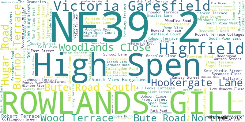
The largest settlement in the NE39 2 postal code is ROWLANDS GILL followed by High Spen, and Highfield.
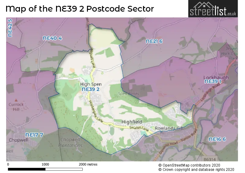
The NE39 2 Postcode shares a border with NE21 6 (BLAYDON-ON-TYNE, Winlaton Mill, Winlaton), NE17 7 (Chopwell, Hamsterley Colliery, Blackhall Mill), NE39 1 (ROWLANDS GILL, Hamsterley Mill, Lintzford) and NE40 4 (RYTON, Greenside, Crawcrook).
The sector is within the post town of ROWLANDS GILL.
NE39 2 is a postcode sector within the NE39 postcode district which is within the NE Newcastle upon Tyne postcode area.
The Royal Mail delivery office for the NE39 2 postal sector is the Blaydon-on-tyne Delivery Office.
The area of the NE39 2 postcode sector is 2.48 square miles which is 6.41 square kilometres or 1,585.08 square acres.

Map of the NE39 2 Postcode Sector
Explore the NE39 2 postcode sector by using our free interactive map.
| N | E | 3 | 9 | - | 2 | X | X |
| N | E | 3 | 9 | Space | 2 | Letter | Letter |
Official List of Streets
ROWLANDS GILL (59 Streets)
High Spen (52 Streets)
Victoria Garesfield (2 Streets)
Highfield (3 Streets)
Unofficial Streets or Alternative Spellings
Weather Forecast for NE39 2
Press Button to Show Forecast for Powerline Mountain Bike Trail
| Time Period | Icon | Description | Temperature | Rain Probability | Wind |
|---|---|---|---|---|---|
| 21:00 to 00:00 | Clear night | 2.0°C (feels like 0.0°C) | 1.00% | N 4 mph |
Press Button to Show Forecast for Powerline Mountain Bike Trail
| Time Period | Icon | Description | Temperature | Rain Probability | Wind |
|---|---|---|---|---|---|
| 00:00 to 03:00 | Partly cloudy (night) | 1.0°C (feels like -1.0°C) | 1.00% | NW 4 mph | |
| 03:00 to 06:00 | Cloudy | 1.0°C (feels like -1.0°C) | 5.00% | WNW 4 mph | |
| 06:00 to 09:00 | Cloudy | 2.0°C (feels like 0.0°C) | 5.00% | NW 4 mph | |
| 09:00 to 12:00 | Cloudy | 5.0°C (feels like 4.0°C) | 13.00% | NE 4 mph | |
| 12:00 to 15:00 | Cloudy | 7.0°C (feels like 5.0°C) | 29.00% | E 4 mph | |
| 15:00 to 18:00 | Light rain shower (day) | 7.0°C (feels like 6.0°C) | 31.00% | ENE 7 mph | |
| 18:00 to 21:00 | Sunny day | 6.0°C (feels like 5.0°C) | 4.00% | E 4 mph | |
| 21:00 to 00:00 | Partly cloudy (night) | 2.0°C (feels like 0.0°C) | 2.00% | SE 4 mph |
Press Button to Show Forecast for Powerline Mountain Bike Trail
| Time Period | Icon | Description | Temperature | Rain Probability | Wind |
|---|---|---|---|---|---|
| 00:00 to 03:00 | Partly cloudy (night) | 1.0°C (feels like 0.0°C) | 2.00% | S 2 mph | |
| 03:00 to 06:00 | Partly cloudy (night) | 1.0°C (feels like -1.0°C) | 4.00% | S 2 mph | |
| 06:00 to 09:00 | Partly cloudy (day) | 2.0°C (feels like 1.0°C) | 5.00% | SE 2 mph | |
| 09:00 to 12:00 | Cloudy | 7.0°C (feels like 5.0°C) | 12.00% | ESE 7 mph | |
| 12:00 to 15:00 | Cloudy | 9.0°C (feels like 7.0°C) | 16.00% | ESE 7 mph | |
| 15:00 to 18:00 | Cloudy | 9.0°C (feels like 7.0°C) | 12.00% | E 9 mph | |
| 18:00 to 21:00 | Partly cloudy (day) | 7.0°C (feels like 5.0°C) | 9.00% | E 9 mph | |
| 21:00 to 00:00 | Cloudy | 4.0°C (feels like 2.0°C) | 12.00% | E 4 mph |
Press Button to Show Forecast for Powerline Mountain Bike Trail
| Time Period | Icon | Description | Temperature | Rain Probability | Wind |
|---|---|---|---|---|---|
| 00:00 to 03:00 | Cloudy | 3.0°C (feels like 1.0°C) | 15.00% | NE 7 mph | |
| 03:00 to 06:00 | Cloudy | 4.0°C (feels like 1.0°C) | 16.00% | NNE 7 mph | |
| 06:00 to 09:00 | Light rain | 5.0°C (feels like 3.0°C) | 46.00% | NNE 9 mph | |
| 09:00 to 12:00 | Light rain | 7.0°C (feels like 4.0°C) | 50.00% | NE 11 mph | |
| 12:00 to 15:00 | Light rain | 8.0°C (feels like 5.0°C) | 52.00% | NNE 11 mph | |
| 15:00 to 18:00 | Light rain | 9.0°C (feels like 6.0°C) | 54.00% | N 9 mph | |
| 18:00 to 21:00 | Light rain shower (day) | 9.0°C (feels like 7.0°C) | 38.00% | NNE 7 mph | |
| 21:00 to 00:00 | Partly cloudy (night) | 5.0°C (feels like 3.0°C) | 10.00% | SE 7 mph |
Schools and Places of Education Within the NE39 2 Postcode Sector
High Spen Primary School
Community school
Hugar Road, Rowlands Gill, Tyne and Wear, NE39 2BQ
Head: Mr Andrew Firth
Ofsted Rating: Good
Inspection: 2022-06-23 (672 days ago)
Website: Visit High Spen Primary School Website
Phone: 01207542373
Number of Pupils: 199
Highfield Community Primary School
Community school
Whinfield Way, Rowlands Gill, Tyne and Wear, NE39 2JE
Head: Mrs Claire Spencer
Ofsted Rating: Good
Inspection: 2018-09-27 (2037 days ago)
Website: Visit Highfield Community Primary School Website
Phone: 01207549882
Number of Pupils: 123
Rowlands Gill Community Primary School
Community school
Dominines Close, Rowlands Gill, Tyne and Wear, NE39 2PP
Head: Mrs Lindsey Clarke
Ofsted Rating: Good
Inspection: 2023-06-15 (315 days ago)
Website: Visit Rowlands Gill Community Primary School Website
Phone: 01207549359
Number of Pupils: 207
St Joseph's Roman Catholic Voluntary Aided Primary School, Highfield
Voluntary aided school
Whinfield Way, Rowlands Gill, Tyne and Wear, NE39 2JE
Head: Ms Joanna Bircham
Ofsted Rating: Good
Inspection: 2023-09-14 (224 days ago)
Website: Visit St Joseph's Roman Catholic Voluntary Aided Primary School, Highfield Website
Phone: 01207545972
Number of Pupils: 101
House Prices in the NE39 2 Postcode Sector
| Type of Property | 2018 Average | 2018 Sales | 2017 Average | 2017 Sales | 2016 Average | 2016 Sales | 2015 Average | 2015 Sales |
|---|---|---|---|---|---|---|---|---|
| Detached | £219,000 | 5 | £249,919 | 13 | £248,543 | 14 | £360,000 | 7 |
| Semi-Detached | £140,821 | 12 | £110,744 | 18 | £120,714 | 14 | £128,723 | 11 |
| Terraced | £108,778 | 39 | £110,369 | 31 | £88,743 | 35 | £108,043 | 41 |
| Flats | £0 | 0 | £115,500 | 1 | £78,250 | 2 | £0 | 0 |
Important Postcodes NE39 2 in the Postcode Sector
NE39 2BQ is the postcode for High Spen Primary School, Hugar Road, High Spen, and High Spen Primary School, Hugar Road
NE39 2BX is the postcode for ADMIN BLOCK HOOKERGATE COMPREHENSIVE, Hookergate Site, Charles Thorp School, and Hookergate Site, Charles Thorp School
NE39 2JE is the postcode for Highfield St. Josephs RC Primary School, Whinfield Way, and Highfield Community Primary School, Whinfield Way
NE39 2PP is the postcode for Rowlands Gill Primary School, Dominies Close
| The NE39 2 Sector is within these Local Authorities |
|
|---|---|
| The NE39 2 Sector is within these Counties |
|
| The NE39 2 Sector is within these Water Company Areas |
|