The NE42 postcode district is a postal district located in the NE Newcastle upon Tyne postcode area with a population of 12,460 residents according to the 2021 England and Wales Census.
The area of the NE42 postcode district is 6.73 square miles which is 17.42 square kilometres or 4,305.72 acres.
Currently, the NE42 district has about 361 postcode units spread across 2 geographic postcode sectors.
Given that each sector allows for 400 unique postcode combinations, the district has a capacity of 800 postcodes. With 361 postcodes already in use, this leaves 439 units available.
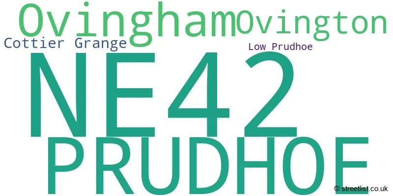
The largest settlement in the NE42 postal code is PRUDHOE followed by Ovingham, and Ovington.
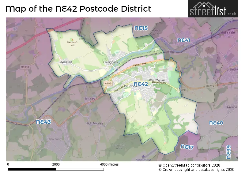
The NE42 Postcode shares a border with NE43 (STOCKSFIELD, Mickley, Newton), NE17 (Chopwell, Hamsterley Colliery, Blackhall Mill), NE41 (WYLAM) and NE15 (NEWCASTLE UPON TYNE, Heddon-on-the-Wall, Lemington).
The primary settlement in the NE42 postcode district is Prudhoe in Northumberland, which has the highest count. Other significant settlements in the district include Cottier Grange, Low Prudhoe, Ovingham, and Ovington, all also located in Northumberland. The most significant post town in the district is Prudhoe.
For the district NE42, we have data on 3 postcode sectors. Here's a breakdown: The sector NE42 5, covers Prudhoe in Northumberland. The sector NE42 6, covers Prudhoe and Ovingham and Ovington in Northumberland. The sector NE42 9 is non-geographic. It's often designated for PO Boxes, large organisations, or special services.

Map of the NE42 Postcode District
Explore the NE42 postcode district by using our free interactive map.
When it comes to local government, postal geography often disregards political borders. However, for a breakdown in the NE42 District: the district mostly encompasses the Northumberland (357 postcodes), and finally, the Gateshead District (B) area (5 postcodes).
Recent House Sales in NE42
| Date | Price | Address |
|---|---|---|
| 20/10/2023 | £120,000 | Bell View, Prudhoe, NE42 5DS |
| 06/10/2023 | £80,000 | Tulip Street, Prudhoe, NE42 6JF |
| 02/10/2023 | £107,500 | Redwell Road, Prudhoe, NE42 5AF |
| 29/09/2023 | £179,000 | Swalwell Close, Prudhoe, NE42 6EX |
| 27/09/2023 | £90,000 | Locomotive Court, Prudhoe, NE42 5JY |
| 08/09/2023 | £260,000 | Beechwood Drive, Prudhoe, NE42 5PN |
| 08/09/2023 | £372,500 | Paddock Wood, Prudhoe, NE42 5BJ |
| 07/09/2023 | £245,000 | Well Dean, Prudhoe, NE42 5QQ |
| 31/08/2023 | £180,000 | Western Avenue, Prudhoe, NE42 6PA |
| 31/08/2023 | £250,000 | Park Lane, Prudhoe, NE42 5LN |
Weather Forecast for NE42
Press Button to Show Forecast for Prudhoe
| Time Period | Icon | Description | Temperature | Rain Probability | Wind |
|---|---|---|---|---|---|
| 00:00 to 03:00 | Overcast | 6.0°C (feels like 4.0°C) | 10.00% | NW 4 mph | |
| 03:00 to 06:00 | Cloudy | 4.0°C (feels like 1.0°C) | 4.00% | NNW 9 mph | |
| 06:00 to 09:00 | Cloudy | 4.0°C (feels like 1.0°C) | 5.00% | NNW 9 mph | |
| 09:00 to 12:00 | Cloudy | 6.0°C (feels like 3.0°C) | 5.00% | N 11 mph | |
| 12:00 to 15:00 | Cloudy | 7.0°C (feels like 4.0°C) | 49.00% | NNE 11 mph | |
| 15:00 to 18:00 | Cloudy | 7.0°C (feels like 4.0°C) | 50.00% | NE 9 mph | |
| 18:00 to 21:00 | Sunny day | 6.0°C (feels like 3.0°C) | 0.00% | NE 9 mph | |
| 21:00 to 00:00 | Partly cloudy (night) | 2.0°C (feels like 0.0°C) | 0.00% | N 4 mph |
Press Button to Show Forecast for Prudhoe
| Time Period | Icon | Description | Temperature | Rain Probability | Wind |
|---|---|---|---|---|---|
| 00:00 to 03:00 | Partly cloudy (night) | 2.0°C (feels like 0.0°C) | 1.00% | NW 4 mph | |
| 03:00 to 06:00 | Cloudy | 1.0°C (feels like -1.0°C) | 5.00% | WNW 4 mph | |
| 06:00 to 09:00 | Cloudy | 2.0°C (feels like 0.0°C) | 9.00% | WNW 4 mph | |
| 09:00 to 12:00 | Cloudy | 6.0°C (feels like 4.0°C) | 9.00% | ENE 4 mph | |
| 12:00 to 15:00 | Overcast | 7.0°C (feels like 5.0°C) | 30.00% | NE 7 mph | |
| 15:00 to 18:00 | Cloudy | 8.0°C (feels like 6.0°C) | 12.00% | ENE 7 mph | |
| 18:00 to 21:00 | Sunny day | 7.0°C (feels like 5.0°C) | 4.00% | E 4 mph | |
| 21:00 to 00:00 | Partly cloudy (night) | 3.0°C (feels like 1.0°C) | 2.00% | ESE 4 mph |
Press Button to Show Forecast for Prudhoe
| Time Period | Icon | Description | Temperature | Rain Probability | Wind |
|---|---|---|---|---|---|
| 00:00 to 03:00 | Partly cloudy (night) | 1.0°C (feels like 0.0°C) | 2.00% | SE 2 mph | |
| 03:00 to 06:00 | Partly cloudy (night) | 1.0°C (feels like -1.0°C) | 3.00% | SSE 2 mph | |
| 06:00 to 09:00 | Partly cloudy (day) | 3.0°C (feels like 1.0°C) | 5.00% | SSE 2 mph | |
| 09:00 to 12:00 | Partly cloudy (day) | 8.0°C (feels like 6.0°C) | 8.00% | ESE 7 mph | |
| 12:00 to 15:00 | Cloudy | 9.0°C (feels like 7.0°C) | 16.00% | ESE 7 mph | |
| 15:00 to 18:00 | Cloudy | 9.0°C (feels like 7.0°C) | 14.00% | E 9 mph | |
| 18:00 to 21:00 | Partly cloudy (day) | 8.0°C (feels like 5.0°C) | 8.00% | E 9 mph | |
| 21:00 to 00:00 | Partly cloudy (night) | 4.0°C (feels like 2.0°C) | 9.00% | E 7 mph |
Press Button to Show Forecast for Prudhoe
| Time Period | Icon | Description | Temperature | Rain Probability | Wind |
|---|---|---|---|---|---|
| 00:00 to 03:00 | Cloudy | 3.0°C (feels like 1.0°C) | 14.00% | NNE 7 mph | |
| 03:00 to 06:00 | Cloudy | 4.0°C (feels like 1.0°C) | 16.00% | NNE 7 mph | |
| 06:00 to 09:00 | Cloudy | 6.0°C (feels like 3.0°C) | 17.00% | N 9 mph | |
| 09:00 to 12:00 | Light rain | 7.0°C (feels like 4.0°C) | 49.00% | NNE 11 mph | |
| 12:00 to 15:00 | Light rain | 8.0°C (feels like 5.0°C) | 50.00% | NNE 11 mph | |
| 15:00 to 18:00 | Light rain | 9.0°C (feels like 6.0°C) | 52.00% | NNE 9 mph | |
| 18:00 to 21:00 | Light rain shower (day) | 9.0°C (feels like 8.0°C) | 38.00% | N 7 mph | |
| 21:00 to 00:00 | Partly cloudy (night) | 5.0°C (feels like 3.0°C) | 9.00% | ESE 7 mph |
Where is the NE42 Postcode District?
The NE42 postcode district is located in Prudhoe, a town in Northumberland. It is surrounded by several nearby towns, including Bedlington to the east (0.32 miles away), Wylam to the northeast (1.69 miles away), Stocksfield to the west (2.99 miles away), Rowlands Gill to the southeast (4.67 miles away), Riding Mill to the southwest (5.31 miles away), and Consett to the south (7.41 miles away). Additionally, Prudhoe is approximately 249.31 miles away from the center of London.
The district is within the post town of PRUDHOE.
The sector has postcodes within the nation of England.
The NE42 Postcode District is covers the following regions.
- Northumberland - Northumberland and Tyne and Wear - North East (England)
- Tyneside - Northumberland and Tyne and Wear - North East (England)
| Postcode Sector | Delivery Office |
|---|---|
| NE42 5 | Prudhoe Delivery Office |
| NE42 6 | Prudhoe Delivery Office |
| N | E | 4 | 2 | - | X | X | X |
| N | E | 4 | 2 | Space | Numeric | Letter | Letter |
Tourist Attractions within the Postcode Area
We found 1 visitor attractions within the NE42 postcode area
| Prudhoe Castle |
|---|
| Historic Properties |
| Castle / Fort |
| View Prudhoe Castle on Google Maps |
Current Monthly Rental Prices
| # Bedrooms | Min Price | Max Price | Avg Price |
|---|---|---|---|
| 1 | £495 | £495 | £495 |
| 3 | £1,400 | £1,400 | £1,400 |
Current House Prices
| # Bedrooms | Min Price | Max Price | Avg Price |
|---|---|---|---|
| £60,000 | £100,000 | £80,000 | |
| 1 | £75,000 | £75,000 | £75,000 |
| 2 | £85,000 | £225,000 | £127,693 |
| 3 | £100,000 | £450,000 | £219,778 |
| 4 | £180,000 | £406,995 | £267,721 |
| 5 | £330,000 | £573,995 | £466,332 |
| 6 | £750,000 | £750,000 | £750,000 |
Estate Agents who Operate in the NE42 District
| Logo | Name | Brand Name | Address | Contact Number | Total Properties |
|---|---|---|---|---|---|
 | Prudhoe | Gilmore Estates | 3a Front Street Prudhoe NE42 5HJ | 01661 525168 | 18 |
 | Prudhoe | Kirsty Hodgson, Powered by eXp UK | Prudhoe, NE42 5QJ | 01661 525201 | 11 |
 | Prudhoe | Red Hot Property | 68 Front Street, Prudhoe, NE42 5AA | 01666 337146 | 7 |
 | Nationwide | Park Move | 8-9 Red Lion Street, Stamford, PE9 1PA | 01780 432725 | 5 |
 | Ryton | Rook Matthews Sayer | 2 Grange Road, Ryton, NE40 3LT | 0191 607 1154 | 3 |
| Type of Property | 2018 Average | 2018 Sales | 2017 Average | 2017 Sales | 2016 Average | 2016 Sales | 2015 Average | 2015 Sales |
|---|---|---|---|---|---|---|---|---|
| Detached | £258,414 | 54 | £241,701 | 50 | £249,365 | 61 | £239,672 | 58 |
| Semi-Detached | £141,870 | 62 | £142,824 | 57 | £142,794 | 56 | £135,937 | 57 |
| Terraced | £132,169 | 55 | £117,322 | 52 | £121,735 | 57 | £135,572 | 40 |
| Flats | £81,250 | 6 | £83,071 | 7 | £81,375 | 4 | £86,500 | 6 |