The NE5 2 postcode sector is within the county of Tyne & Wear.
Did you know? According to the 2021 Census, the NE5 2 postcode sector is home to a bustling 14,671 residents!
Given that each sector allows for 400 unique postcode combinations. Letters C, I, K, M, O and V are not allowed in the last two letters of a postcode. With 295 postcodes already in use, this leaves 105 units available.
The largest settlements in the NE5 2 postal code are NEWCASTLE UPON TYNE and East Denton.
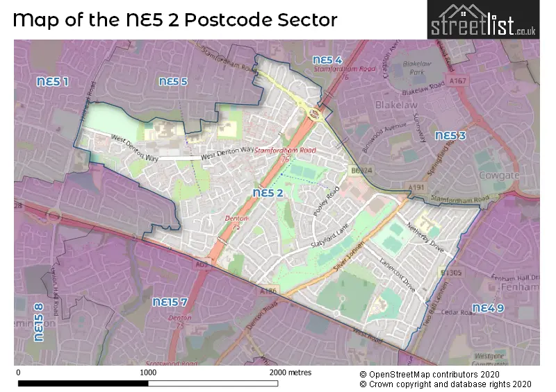
The NE5 2 Postcode shares a border with NE4 9 (NEWCASTLE UPON TYNE, Fenham), NE5 3 (NEWCASTLE UPON TYNE, Cowgate), NE5 4 (NEWCASTLE UPON TYNE), NE5 1 (NEWCASTLE UPON TYNE, Callerton, Chapel Park), NE5 5 (NEWCASTLE UPON TYNE, Westerhope, West Denton), NE15 6 (NEWCASTLE UPON TYNE, Benwell Grange) and NE15 7 (NEWCASTLE UPON TYNE, Lemington, West Denton).
The sector is within the post town of NEWCASTLE UPON TYNE.
NE5 2 is a postcode sector within the NE5 postcode district which is within the NE Newcastle upon Tyne postcode area.
The Royal Mail delivery office for the NE5 2 postal sector is the West Delivery Office (ne).
The area of the NE5 2 postcode sector is 1.24 square miles which is 3.20 square kilometres or 791.18 square acres.
The NE5 2 postcode sector is crossed by the A1 Major A road.
The NE5 2 postcode sector is crossed by the A69 Major A road.

Map of the NE5 2 Postcode Sector
Explore the NE5 2 postcode sector by using our free interactive map.
| N | E | 5 | - | 2 | X | X |
| N | E | 5 | Space | 2 | Letter | Letter |
Official List of Streets
NEWCASTLE UPON TYNE (174 Streets)
Denton Burn (2 Streets)
West Denton (2 Streets)
Westerhope (3 Streets)
Unofficial Streets or Alternative Spellings
NEWCASTLE UPON TYNE
BROADWOOD ROAD GREELY ROAD GREENLAW HILLHEAD PARKWAY HILLHEAD ROAD MARSDEN LANE SOUTHWAY SPRINGFIELD ROAD BIRCHVALE AVENUE DEER BUSH DEERBRUSH EAST DENTON INTERCHANGE FAIRLEY WALK FORESTBORNE COURT FOX AND HOUNDS LANE FOX AND HOUNDS ROAD QUEENS ROAD SHAP LANE ST CUTHERTS GREEN STAMFORDHAM ROAD INTERCHANGE TALBOT ROWPonteland
STAMFORDHAM ROADWeather Forecast for NE5 2
Press Button to Show Forecast for East Denton
| Time Period | Icon | Description | Temperature | Rain Probability | Wind |
|---|---|---|---|---|---|
| 18:00 to 21:00 | Sunny day | 6.0°C (feels like 3.0°C) | 0.00% | NNE 9 mph | |
| 21:00 to 00:00 | Partly cloudy (night) | 4.0°C (feels like 2.0°C) | 1.00% | N 4 mph |
Press Button to Show Forecast for East Denton
| Time Period | Icon | Description | Temperature | Rain Probability | Wind |
|---|---|---|---|---|---|
| 00:00 to 03:00 | Partly cloudy (night) | 3.0°C (feels like 0.0°C) | 1.00% | NNW 4 mph | |
| 03:00 to 06:00 | Cloudy | 2.0°C (feels like 0.0°C) | 8.00% | NNW 4 mph | |
| 06:00 to 09:00 | Cloudy | 3.0°C (feels like 0.0°C) | 5.00% | NNW 4 mph | |
| 09:00 to 12:00 | Cloudy | 6.0°C (feels like 4.0°C) | 49.00% | NNE 4 mph | |
| 12:00 to 15:00 | Cloudy | 7.0°C (feels like 5.0°C) | 27.00% | NE 4 mph | |
| 15:00 to 18:00 | Overcast | 8.0°C (feels like 6.0°C) | 10.00% | ENE 7 mph | |
| 18:00 to 21:00 | Partly cloudy (day) | 7.0°C (feels like 5.0°C) | 5.00% | E 7 mph | |
| 21:00 to 00:00 | Partly cloudy (night) | 3.0°C (feels like 1.0°C) | 2.00% | ESE 4 mph |
Press Button to Show Forecast for East Denton
| Time Period | Icon | Description | Temperature | Rain Probability | Wind |
|---|---|---|---|---|---|
| 00:00 to 03:00 | Clear night | 3.0°C (feels like 1.0°C) | 2.00% | S 4 mph | |
| 03:00 to 06:00 | Partly cloudy (night) | 2.0°C (feels like 0.0°C) | 4.00% | SSW 2 mph | |
| 06:00 to 09:00 | Partly cloudy (day) | 3.0°C (feels like 2.0°C) | 6.00% | S 2 mph | |
| 09:00 to 12:00 | Cloudy | 7.0°C (feels like 5.0°C) | 11.00% | ESE 7 mph | |
| 12:00 to 15:00 | Cloudy | 9.0°C (feels like 7.0°C) | 13.00% | ESE 7 mph | |
| 15:00 to 18:00 | Cloudy | 8.0°C (feels like 6.0°C) | 12.00% | E 9 mph | |
| 18:00 to 21:00 | Partly cloudy (day) | 8.0°C (feels like 5.0°C) | 9.00% | E 9 mph | |
| 21:00 to 00:00 | Cloudy | 5.0°C (feels like 3.0°C) | 13.00% | E 7 mph |
Press Button to Show Forecast for East Denton
| Time Period | Icon | Description | Temperature | Rain Probability | Wind |
|---|---|---|---|---|---|
| 00:00 to 03:00 | Cloudy | 5.0°C (feels like 2.0°C) | 15.00% | NE 7 mph | |
| 03:00 to 06:00 | Overcast | 5.0°C (feels like 2.0°C) | 19.00% | NNE 9 mph | |
| 06:00 to 09:00 | Overcast | 6.0°C (feels like 3.0°C) | 21.00% | NE 11 mph | |
| 09:00 to 12:00 | Light rain | 7.0°C (feels like 4.0°C) | 51.00% | NE 13 mph | |
| 12:00 to 15:00 | Heavy rain | 8.0°C (feels like 5.0°C) | 74.00% | NNE 13 mph | |
| 15:00 to 18:00 | Light rain | 8.0°C (feels like 5.0°C) | 55.00% | NNE 11 mph | |
| 18:00 to 21:00 | Heavy rain | 9.0°C (feels like 7.0°C) | 71.00% | N 7 mph | |
| 21:00 to 00:00 | Partly cloudy (night) | 6.0°C (feels like 4.0°C) | 10.00% | SE 7 mph |
Schools and Places of Education Within the NE5 2 Postcode Sector
Beech Hill Primary School
Academy converter
Linhope Road, Newcastle-upon-Tyne, Tyne and Wear, NE5 2LW
Head: Mrs Jess Eatock
Ofsted Rating: Good
Inspection: 2023-03-08 (414 days ago)
Website: Visit Beech Hill Primary School Website
Phone: 01912678113
Number of Pupils: 456
Mary Astell Academy
Academy alternative provision sponsor led
Linhope Road, Newcastle-upon-Tyne, Tyne and Wear, NE5 2LW
Head: Mrs Andrea Spowart
Ofsted Rating: Requires improvement
Inspection: 2022-06-09 (686 days ago)
Website: Visit Mary Astell Academy Website
Phone: 01912674447
Number of Pupils: 64
Stocksfield Avenue Primary School
Academy converter
St Cuthbert's Road, Newcastle-upon-Tyne, Tyne and Wear, NE5 2DQ
Head: Mr David Lynch
Ofsted Rating: Good
Inspection: 2019-05-23 (1799 days ago)
Website: Visit Stocksfield Avenue Primary School Website
Phone: 01912748434
Number of Pupils: 446
Studio West
Studio schools
West Denton Way, Newcastle-upon-Tyne, , NE5 2SZ
Head: Mr Craig Knowles
Ofsted Rating: Good
Inspection: 2019-05-01 (1821 days ago)
Website: Visit Studio West Website
Phone: 01914813710
Number of Pupils: 573
Thomas Bewick School
Academy special converter
Linhope Road, Newcastle-upon-Tyne, Tyne and Wear, NE5 2LW
Head: Mrs Katy Harrison
Ofsted Rating: Good
Inspection: 2023-09-20 (218 days ago)
Website: Visit Thomas Bewick School Website
Phone: 01912296020
Number of Pupils: 314
House Prices in the NE5 2 Postcode Sector
| Type of Property | 2018 Average | 2018 Sales | 2017 Average | 2017 Sales | 2016 Average | 2016 Sales | 2015 Average | 2015 Sales |
|---|---|---|---|---|---|---|---|---|
| Detached | £172,569 | 14 | £175,591 | 11 | £156,141 | 8 | £161,322 | 9 |
| Semi-Detached | £128,982 | 79 | £131,147 | 70 | £130,640 | 55 | £127,010 | 91 |
| Terraced | £109,904 | 92 | £109,545 | 95 | £106,577 | 80 | £96,825 | 73 |
| Flats | £73,929 | 21 | £69,854 | 24 | £75,103 | 37 | £68,280 | 25 |
Important Postcodes NE5 2 in the Postcode Sector
NE5 2AA is the postcode for Royal Mail, West Delivery Office, 5 Slatyford Lane
NE5 2DQ is the postcode for Stocksfield Avenue Primary School House, St. Cuthberts Road, and Stocksfield Avenue Primary School, St. Cuthberts Road
NE5 2JL is the postcode for Newcastle Crematorium Lodge, West Road, and Newcastle Crematorium, West Road
NE5 2LW is the postcode for Mary Astell Academy, Linhope Road, MAIN BUILDING, Beech Hill Primary School, Linhope Road, EARLY YEARS BUILDING, Beech Hill Primary School, Linhope Road, Beech Hill Primary School, Linhope Road, and Thomas Bewick School, Linhope Road
NE5 2QW is the postcode for Denton Park Health Centre, Unit 12 Denton Park Shopping Centre, West Denton Way
NE5 2QZ is the postcode for Newcastle City Council, Outer West Library, West Denton Way, Newcastle City Council, Outer West Pool, West Denton Way, Outer West Library, Customer Service Centre (CSC) & Housing Office, Outer West Customer Service Centre, West Denton Way, Denton Park Centre, Outer West Customer Service Centre, Denton Park Shopping Centre, West Denton Way, NORTH COUNTRY LEISURE - WEST DENTON POOL, Newcastle City Council, Outer West Pool, West Denton Way, and WEST DENTON LEISURE CENTRE, Newcastle City Council, Outer West Pool, West Denton Way
NE5 2RB is the postcode for Tyne & Wear Fire & Rescue Service, Fire Station, West Denton Way
NE5 2SA is the postcode for English Martyrs RC Primary School, Beaufront Gardens
NE5 2SZ is the postcode for West Denton Gym, West Denton Leisure Centre, West Denton Way, Studio West, West Denton Way, Studio West, West Denton Way, West Denton, WEST DENTON LEISURE CENTRE, Studio West, West Denton Way, and SPORTS HALL, Studio West, West Denton Way
NE5 2TA is the postcode for Slatyford Youth Centre, Bowness Road
NE5 2TX is the postcode for Thomas Bewick School, West Denton Way
NE5 2UP is the postcode for Slatyford Lane Child Unit, Slatyford Lane
| The NE5 2 Sector is within these Local Authorities |
|
|---|---|
| The NE5 2 Sector is within these Counties |
|
| The NE5 2 Sector is within these Water Company Areas |
|