This section of the site is all about the NG Postcode area, also known as the Nottingham Postal Area. Explore links to the next level to learn more about specific postcode districts such as NG1.

The NG postcode area represents a group of postal districts in the Nottingham area of the United Kingdom. The area code NG stands for the letters n and g in NottinGham. NG has a population of 1,163,185 and covers an area of 2,648,687 hectares. Fun fact: 1.79% of the population of Great Britain lives in this area.
The postcode area falls within the following counties: Nottinghamshire (82.19%), Lincolnshire (11.39%), Derbyshire (5.69%), Leicestershire (0.73%).
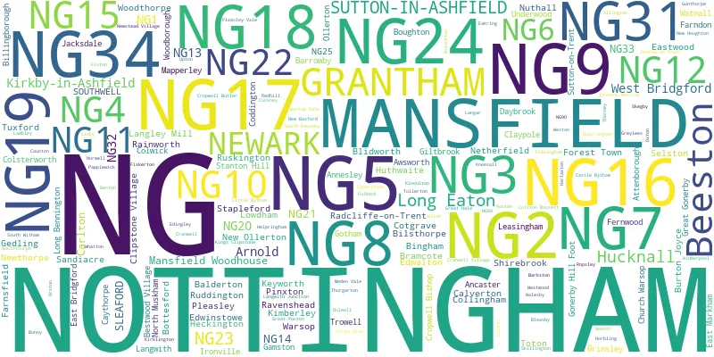
Post Towns and Postcode Districts for the NG Postcode
-
NG1 NottinghamshireNG2 NottinghamshireNG3 NottinghamshireNG4 NottinghamshireNG5 NottinghamshireNG6 NottinghamshireNG7 NottinghamshireNG8 NottinghamshireNG9 NottinghamshireNG10 DerbyshireNG11 NottinghamshireNG12 NottinghamshireNG13 Leicestershire (18%), Lincolnshire (1%), Nottinghamshire (79%)NG14 NottinghamshireNG15 NottinghamshireNG16 Derbyshire (18%), Nottinghamshire (81%)NG17 NottinghamshireNG80 NG90
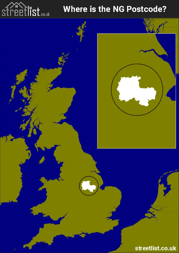
Where is the NG Postcode Area?
The NG Nottingham postcode area is in East Midlands of England. The postal area borders the following neighbouring postal areas: DE - Derby, LN - Lincoln, LE - Leicester, PE - Peterborough, S - Sheffield and DN - Doncaster, and is located inland.
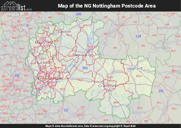
Map of the NG Nottingham Postcode Area
Explore the NG Nottingham postcode area by using our interactive map.
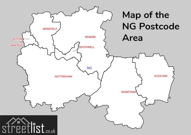
Postcode Districts within the NG Nottingham Postcode Area
There are 29 postcode districts within the Nottingham postcode area
A map showing the boundary of in relation to other areas
There are 23 towns within the Nottingham postcode area.
| Unit | Area² |
|---|---|
| Hectares | 2,648,687² |
| Miles | 10,227² |
| Feet | 285,102,019,993² |
| Kilometres | 26,487² |
Postal Delivery Offices serving the NG Nottingham Postcode Area
- Aslockton Scale Payment Delivery Office
- Barkstone Scale Payment Delivery Office
- Beeston Delivery Office
- Bilsthorpe Scale Payment Delivery Office
- Bingham Scale Payment Delivery Office
- Bottesford Scale Payment Delivery Office
- Bulwell Delivery Office
- Burton Joyce Scale Payment Delivery Office
- Calverton Scale Payment Delivery Office
- Carlton (ng) Delivery Office
- Clifton (ng) Delivery Office
- Colston Bassett Scale Payment Delivery Office
- Cotgrave Scale Payment Delivery Office
- Cropwell Bishop Scale Payment Delivery Office
- Eastwood Delivery Office
- Glaisdale Parkway Delivery Office
- Gotham Scale Payment Delivery Office
- Grantham Delivery Office
- Hucknall Delivery Office
- Keyworth Scale Payment Delivery Office
- Kinoulton Scale Payment Delivery Office
- Kirkby-in-ashfield Delivery Office
- Langar Scale Payment Delivery Office
- Long Eaton Delivery Office
- Lowdham Scale Payment Delivery Office
- Mansfield Delivery Office
- Newark Delivery Office
- Nottingham City Delivery Office
- Nottingham North Delivery Office
- Nottingham South Delivery Office
- Pinxton Scale Payment Delivery Office
- Ravenshead Scale Payment Delivery Office
- Redmile Scale Payment Delivery Office
- Shirebrook Scale Payment Delivery Office
- Sleaford Delivery Office
- Sutton-in-ashfield Delivery Office
- Tuxford Scale Payment Delivery Office
- Walesby Scale Payment Delivery Office
- Warsop Scale Payment Delivery Office
- Woodborough Scale Payment Delivery Office
Councils with Postcodes in NG
Towns and Villages within the NG Nottingham Postcode Area
- Allington - village
- Ancaster - village
- Annesley Woodhouse - village
- Anwick - village
- Arnold - town
- Askham - village
- Aslackby - village
- Aslockton - village
- Aswarby - otherSettlement
- Aunsby - village
- Averham - village
- Awsworth - village
- Balderton - village
- Barkestone-le-Vale - village
- Barkston - village
- Barnby in the Willows - village
- Barnstone - village
- Barrowby - village
- Barton in Fabis - village
- Bathley - village
- Beeston - town
- Belton - village
- Belvoir - otherSettlement
- Besthorpe - village
- Bestwood St Albans - village
- Bestwood Village - village
- Billingborough - village
- Bilsthorpe - village
- Bitchfield - village
- Bleasby - village
- Blidworth - village
- Boothby Pagnell - village
- Bottesford - village
- Boughton - village
- Bradmore - village
- Brandon - village
- Branston - village
- Brinsley - village
- Buckminster - village
- Bulcote - village
- Bunny - village
- Burton Joyce - village
- Burton Pedwardine - otherSettlement
- Burton-le-Coggles - village
- Calverton - village
- Car Colston - village
- Carlton - Settlement
- Carlton Scroop - village
- Carlton-on-Trent - village
- Castle Bytham - village
- Caunton - village
- Caythorpe - village
- Caythorpe - village
- Church Warsop - village
- Claypole - village
- Clifton - Urban Area
- Clipstone - village
- Coddington - village
- Collingham - village
- Colsterworth - village
- Colston Bassett - village
- Corby Glen - village
- Cossall - village
- Cotgrave - town
- Cotham - village
- Cranwell - village
- Cromwell - village
- Cropwell Bishop - village
- Cropwell Butler - village
- Cuckney - village
- Darlton - village
- Denton - village
- Dry Doddington - village
- Dunham on Trent - village
- Eakring - village
- East Bridgford - village
- East Markham - village
- East Stoke - village
- Easton - otherSettlement
- Eastwood - town
- Eaton - village
- Edingley - village
- Edwalton - village
- Edwinstowe - village
- Egmanton - village
- Elston - village
- Elton on the Hill - village
- Epperstone - village
- Evedon - village
- Ewerby - village
- Fackley - village
- Farndon - village
- Farnsfield - village
- Fenton - village
- Fiskerton - village
- Flintham - village
- Folkingham - village
- Foston - village
- Frieston - village
- Fulbeck - village
- Gamston - village
- Gonalston - village
- Gonerby Moor - otherSettlement
- Gotham - village
- Granby - village
- Grantham - town
- Great Gonerby - village
- Great Hale - village
- Great Ponton - village
- Greylees - village
- Gunthorpe - village
- Halam - village
- Harby - village
- Harlaxton - village
- Harlow Wood - village
- Harston - village
- Hawksworth - village
- Heanor - town
- Heckington - town
- Helpringham - village
- Hockerton - village
- Honington - village
- Horbling - village
- Hough-on-the-Hill - village
- Hougham - village
- Hoveringham - village
- Hucknall - town
- Hungerton - otherSettlement
- Huthwaite - village
- Ilkeston - town
- Ingoldsby - village
- Irnham - village
- Ironville - village
- Jacksdale - village
- Kelham - village
- Keyworth - village
- Kimberley - town
- Kings Clipstone - village
- Kingston on Soar - village
- Kinoulton - village
- Kirkby la Thorpe - village
- Kirkby-in-Ashfield - town
- Kirklington - village
- Kirton - village
- Kneesall - village
- Knipton - village
- Lambley - village
- Langar - village
- Langford - otherSettlement
- Langwith - village
- Laughton - otherSettlement
- Laxton - village
- Leasingham - village
- Lenton - village
- Linby - village
- Little Bytham - village
- Little Carlton - village
- Little Hale - village
- Little Ponton - village
- Londonthorpe - village
- Long Bennington - village
- Long Eaton - town
- Lowdham - village
- Mansfield - town
- Mansfield Woodhouse - town
- Maplebeck - village
- Market Warsop - town
- Markham Moor - village
- Marston - village
- Meden Vale - village
- Milton - village
- Moorhouse - otherSettlement
- Morton - village
- Muston - village
- New Houghton - village
- New Ollerton - village
- Newark-on-Trent - town
- Newlands - village
- Newstead - village
- Newton - village
- Newton - village
- Normanton on Trent - village
- Normanton-on-Cliffe - village
- Normanton-on-the-Wolds - village
- North Clifton - village
- North Muskham - village
- North Rauceby - village
- North Witham - village
- Norton - village
- Norwell - village
- Nottingham - city
- Nuthall - village
- Oasby - village
- Old Somerby - village
- Ollerton - village
- Orston - village
- Osbournby - village
- Ossington - village
- Oxton - village
- Papplewick - village
- Perlethorpe - village
- Pickworth - village
- Pinxton - village
- Pleasley - village
- Pleasley Vale - otherSettlement
- Plumtree - village
- Plungar - village
- Pointon - village
- Pye Bridge - village
- Radcliffe on Trent - village
- Rainworth - village
- Ratcliffe on Soar - village
- Ravenshead - village
- Redmile - village
- Rolleston - village
- Ropsley - village
- Ruddington - village
- Ruskington - village
- Sandiacre - town
- Scarrington - village
- Scredington - village
- Screveton - village
- Sedgebrook - village
- Selston - village
- Sewstern - village
- Shelford - village
- Shelton - village
- Shirebrook - town
- Silk Willoughby - village
- Skegby - village
- Skillington - village
- Sleaford - town
- South Clifton - village
- South Muskham - village
- South Rauceby - village
- South Scarle - village
- South Witham - village
- Southwell - town
- Spalford - otherSettlement
- Spion Kop - village
- Stainby - village
- Stanton Hill - village
- Stanton-on-the-Wolds - village
- Stapleford - town
- Staythorpe - village
- Stoke Bardolph - village
- Stoke Rochford - village
- Strelley - village
- Stubton - village
- Sudbrook - village
- Sutton in Ashfield - town
- Sutton on Trent - village
- Swarby - village
- Swaton - village
- Swayfield - village
- Swingate - village
- Swinstead - village
- Syerston - village
- Syston - village
- Teversal - village
- Thoresby - otherSettlement
- Thorney - village
- Thorney Moor - otherSettlement
- Threekingham - village
- Thrumpton - village
- Thurgarton - village
- Tollerton - village
- Trowell - village
- Tuxford - village
- Underwood - village
- Upper Saxondale - village
- Upton - village
- Walesby - village
- Warsop Vale - village
- Watnall - village
- Welby - village
- Wellow - village
- West Bridgford - town
- West Markham - village
- Westborough - village
- Weston - village
- Westwood - village
- Whaley Thorns - village
- Whatton-in-the-Vale - village
- Widmerpool - village
- Wigsley - village
- Wilford - village
- Wilsford - village
- Winthorpe - village
- Woodborough - village
- Woodlinkin - village
- Woolsthorpe by Belvoir - village
- Woolsthorpe-by-Colsterworth - village
- Wysall - village