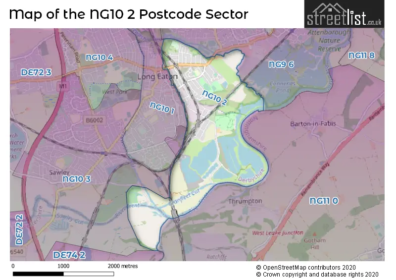
The NG10 2 postcode sector lies where the three counties of Derbyshire, Nottinghamshire, and Leicestershire meet.
Did you know? According to the 2021 Census, the NG10 2 postcode sector is home to a bustling 4,869 residents!
Given that each sector allows for 400 unique postcode combinations. Letters C, I, K, M, O and V are not allowed in the last two letters of a postcode. With 97 postcodes already in use, this leaves 303 units available.
The NG10 2 postal code covers the settlement of Long Eaton.
The NG10 2 Postcode shares a border with NG10 1 (Long Eaton), NG10 3 (Long Eaton), NG11 0 (Gotham, Ratcliffe-on-Soar, Barton-in-Fabis), NG9 6 (Toton, Beeston, Attenborough) and DE74 2 (Castle Donington, Kegworth, Diseworth).
The sector is within the post town of NOTTINGHAM.
NG10 2 is a postcode sector within the NG10 postcode district which is within the NG Nottingham postcode area.
The Royal Mail delivery office for the NG10 2 postal sector is the Long Eaton Delivery Office.
The area of the NG10 2 postcode sector is 2.01 square miles which is 5.21 square kilometres or 1,286.58 square acres.
Waterways within the NG10 2 postcode sector include the River Trent, River Soar, Erewash Canal, Cranfleet Cut, River Erewash.

Map of the NG10 2 Postcode Sector
Explore the NG10 2 postcode sector by using our free interactive map.
| N | G | 1 | 0 | - | 2 | X | X |
| N | G | 1 | 0 | Space | 2 | Letter | Letter |
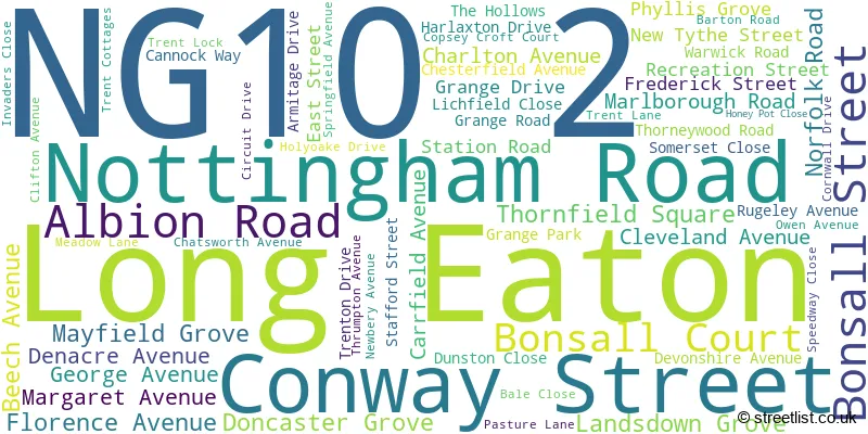
Official List of Streets
Long Eaton (59 Streets)
Unofficial Streets or Alternative Spellings
Weather Forecast for NG10 2
Press Button to Show Forecast for Long Eaton
| Time Period | Icon | Description | Temperature | Rain Probability | Wind |
|---|---|---|---|---|---|
| 00:00 to 03:00 | Cloudy | 7.0°C (feels like 4.0°C) | 4.00% | NNW 7 mph | |
| 03:00 to 06:00 | Partly cloudy (night) | 5.0°C (feels like 3.0°C) | 0.00% | NNW 7 mph | |
| 06:00 to 09:00 | Sunny day | 5.0°C (feels like 2.0°C) | 0.00% | NNW 9 mph | |
| 09:00 to 12:00 | Cloudy | 8.0°C (feels like 5.0°C) | 4.00% | N 11 mph | |
| 12:00 to 15:00 | Cloudy | 9.0°C (feels like 7.0°C) | 5.00% | N 11 mph | |
| 15:00 to 18:00 | Cloudy | 11.0°C (feels like 8.0°C) | 4.00% | N 9 mph | |
| 18:00 to 21:00 | Cloudy | 10.0°C (feels like 8.0°C) | 4.00% | NNE 7 mph | |
| 21:00 to 00:00 | Cloudy | 7.0°C (feels like 6.0°C) | 3.00% | NE 4 mph |
Press Button to Show Forecast for Long Eaton
| Time Period | Icon | Description | Temperature | Rain Probability | Wind |
|---|---|---|---|---|---|
| 00:00 to 03:00 | Partly cloudy (night) | 5.0°C (feels like 4.0°C) | 1.00% | SW 4 mph | |
| 03:00 to 06:00 | Partly cloudy (night) | 4.0°C (feels like 2.0°C) | 1.00% | WSW 7 mph | |
| 06:00 to 09:00 | Cloudy | 5.0°C (feels like 2.0°C) | 5.00% | W 7 mph | |
| 09:00 to 12:00 | Partly cloudy (day) | 8.0°C (feels like 6.0°C) | 5.00% | WNW 11 mph | |
| 12:00 to 15:00 | Cloudy | 10.0°C (feels like 8.0°C) | 9.00% | WNW 9 mph | |
| 15:00 to 18:00 | Cloudy | 11.0°C (feels like 9.0°C) | 8.00% | NNW 9 mph | |
| 18:00 to 21:00 | Cloudy | 9.0°C (feels like 7.0°C) | 8.00% | N 7 mph | |
| 21:00 to 00:00 | Cloudy | 7.0°C (feels like 5.0°C) | 6.00% | NNE 7 mph |
Press Button to Show Forecast for Long Eaton
| Time Period | Icon | Description | Temperature | Rain Probability | Wind |
|---|---|---|---|---|---|
| 00:00 to 03:00 | Partly cloudy (night) | 5.0°C (feels like 3.0°C) | 2.00% | NE 4 mph | |
| 03:00 to 06:00 | Cloudy | 4.0°C (feels like 2.0°C) | 5.00% | ENE 4 mph | |
| 06:00 to 09:00 | Cloudy | 4.0°C (feels like 2.0°C) | 7.00% | ENE 4 mph | |
| 09:00 to 12:00 | Cloudy | 7.0°C (feels like 5.0°C) | 8.00% | ENE 7 mph | |
| 12:00 to 15:00 | Overcast | 10.0°C (feels like 8.0°C) | 13.00% | ESE 7 mph | |
| 15:00 to 18:00 | Cloudy | 10.0°C (feels like 9.0°C) | 12.00% | E 7 mph | |
| 18:00 to 21:00 | Cloudy | 9.0°C (feels like 7.0°C) | 11.00% | E 9 mph | |
| 21:00 to 00:00 | Cloudy | 7.0°C (feels like 5.0°C) | 13.00% | E 9 mph |
Press Button to Show Forecast for Long Eaton
| Time Period | Icon | Description | Temperature | Rain Probability | Wind |
|---|---|---|---|---|---|
| 00:00 to 03:00 | Cloudy | 7.0°C (feels like 4.0°C) | 16.00% | E 7 mph | |
| 03:00 to 06:00 | Overcast | 6.0°C (feels like 4.0°C) | 18.00% | E 7 mph | |
| 06:00 to 09:00 | Cloudy | 6.0°C (feels like 4.0°C) | 14.00% | ENE 7 mph | |
| 09:00 to 12:00 | Overcast | 9.0°C (feels like 6.0°C) | 16.00% | ENE 9 mph | |
| 12:00 to 15:00 | Overcast | 11.0°C (feels like 9.0°C) | 31.00% | E 9 mph | |
| 15:00 to 18:00 | Cloudy | 12.0°C (feels like 10.0°C) | 16.00% | E 9 mph | |
| 18:00 to 21:00 | Light rain shower (day) | 11.0°C (feels like 9.0°C) | 32.00% | ENE 9 mph | |
| 21:00 to 00:00 | Cloudy | 9.0°C (feels like 7.0°C) | 15.00% | ENE 9 mph |
Schools and Places of Education Within the NG10 2 Postcode Sector
Grange Primary School
Community school
Station Road, Nottingham, Nottinghamshire, NG10 2DU
Head: Mrs Zoe Buxton
Ofsted Rating: Good
Inspection: 2021-05-26 (1064 days ago)
Website: Visit Grange Primary School Website
Phone: 01159734956
Number of Pupils: 432
House Prices in the NG10 2 Postcode Sector
| Type of Property | 2018 Average | 2018 Sales | 2017 Average | 2017 Sales | 2016 Average | 2016 Sales | 2015 Average | 2015 Sales |
|---|---|---|---|---|---|---|---|---|
| Detached | £281,968 | 23 | £238,165 | 26 | £218,280 | 23 | £211,444 | 18 |
| Semi-Detached | £161,526 | 58 | £157,327 | 40 | £138,003 | 33 | £139,010 | 47 |
| Terraced | £118,094 | 24 | £114,218 | 25 | £104,859 | 22 | £101,398 | 27 |
| Flats | £81,000 | 1 | £82,500 | 2 | £81,500 | 2 | £80,750 | 4 |
Important Postcodes NG10 2 in the Postcode Sector
NG10 2BZ is the postcode for Child & Adolescent Mental Health Service, Century House, 100 Nottingham Road
NG10 2DU is the postcode for Main Building, Grange Primary School, Station Road, and Grange Primary School, Station Road
| The NG10 2 Sector is within these Local Authorities |
|
|---|---|
| The NG10 2 Sector is within these Counties |
|
| The NG10 2 Sector is within these Water Company Areas |
|