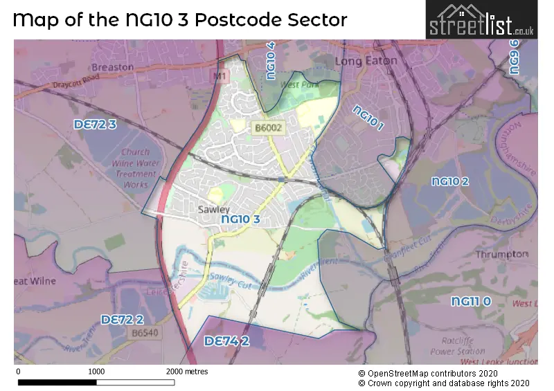
The NG10 3 postcode sector stands on the Derbyshire and Leicestershire border.
Did you know? According to the 2021 Census, the NG10 3 postcode sector is home to a bustling 14,482 residents!
Given that each sector allows for 400 unique postcode combinations. Letters C, I, K, M, O and V are not allowed in the last two letters of a postcode. With 255 postcodes already in use, this leaves 145 units available.
The NG10 3 postal code covers the settlement of Long Eaton.
The NG10 3 Postcode shares a border with NG10 1 (Long Eaton), NG10 4 (Long Eaton), DE72 2 (Shardlow, Aston-on-Trent, Weston-on-Trent), DE72 3 (Borrowash, Breaston, Draycott), NG10 2 (Long Eaton) and DE74 2 (Castle Donington, Kegworth, Diseworth).
The sector is within the post town of NOTTINGHAM.
NG10 3 is a postcode sector within the NG10 postcode district which is within the NG Nottingham postcode area.
The Royal Mail delivery office for the NG10 3 postal sector is the Long Eaton Delivery Office.
The area of the NG10 3 postcode sector is 2.58 square miles which is 6.68 square kilometres or 1,649.94 square acres.
The NG10 3 postcode sector is crossed by the M1 motorway.
Waterways within the NG10 3 postcode sector include the River Trent, Sawley Cut, Erewash Canal.

Map of the NG10 3 Postcode Sector
Explore the NG10 3 postcode sector by using our free interactive map.
| N | G | 1 | 0 | - | 3 | X | X |
| N | G | 1 | 0 | Space | 3 | Letter | Letter |
Official List of Streets
Long Eaton (174 Streets)
Unofficial Streets or Alternative Spellings
Weather Forecast for NG10 3
Press Button to Show Forecast for Long Eaton
| Time Period | Icon | Description | Temperature | Rain Probability | Wind |
|---|---|---|---|---|---|
| 21:00 to 00:00 | Cloudy | 8.0°C (feels like 6.0°C) | 4.00% | N 7 mph |
Press Button to Show Forecast for Long Eaton
| Time Period | Icon | Description | Temperature | Rain Probability | Wind |
|---|---|---|---|---|---|
| 00:00 to 03:00 | Cloudy | 7.0°C (feels like 4.0°C) | 4.00% | NNW 7 mph | |
| 03:00 to 06:00 | Partly cloudy (night) | 5.0°C (feels like 3.0°C) | 0.00% | NNW 7 mph | |
| 06:00 to 09:00 | Sunny day | 5.0°C (feels like 2.0°C) | 0.00% | NNW 9 mph | |
| 09:00 to 12:00 | Cloudy | 8.0°C (feels like 5.0°C) | 4.00% | N 11 mph | |
| 12:00 to 15:00 | Cloudy | 9.0°C (feels like 7.0°C) | 5.00% | N 11 mph | |
| 15:00 to 18:00 | Cloudy | 11.0°C (feels like 8.0°C) | 4.00% | N 9 mph | |
| 18:00 to 21:00 | Cloudy | 10.0°C (feels like 8.0°C) | 4.00% | NNE 7 mph | |
| 21:00 to 00:00 | Cloudy | 7.0°C (feels like 6.0°C) | 3.00% | NE 4 mph |
Press Button to Show Forecast for Long Eaton
| Time Period | Icon | Description | Temperature | Rain Probability | Wind |
|---|---|---|---|---|---|
| 00:00 to 03:00 | Partly cloudy (night) | 5.0°C (feels like 4.0°C) | 1.00% | SW 4 mph | |
| 03:00 to 06:00 | Partly cloudy (night) | 4.0°C (feels like 2.0°C) | 1.00% | WSW 7 mph | |
| 06:00 to 09:00 | Cloudy | 5.0°C (feels like 2.0°C) | 5.00% | W 7 mph | |
| 09:00 to 12:00 | Partly cloudy (day) | 8.0°C (feels like 6.0°C) | 5.00% | WNW 11 mph | |
| 12:00 to 15:00 | Cloudy | 10.0°C (feels like 8.0°C) | 9.00% | WNW 9 mph | |
| 15:00 to 18:00 | Cloudy | 11.0°C (feels like 9.0°C) | 8.00% | NNW 9 mph | |
| 18:00 to 21:00 | Cloudy | 9.0°C (feels like 7.0°C) | 8.00% | N 7 mph | |
| 21:00 to 00:00 | Cloudy | 7.0°C (feels like 5.0°C) | 6.00% | NNE 7 mph |
Press Button to Show Forecast for Long Eaton
| Time Period | Icon | Description | Temperature | Rain Probability | Wind |
|---|---|---|---|---|---|
| 00:00 to 03:00 | Partly cloudy (night) | 5.0°C (feels like 3.0°C) | 2.00% | NE 4 mph | |
| 03:00 to 06:00 | Cloudy | 4.0°C (feels like 2.0°C) | 5.00% | ENE 4 mph | |
| 06:00 to 09:00 | Cloudy | 4.0°C (feels like 2.0°C) | 7.00% | ENE 4 mph | |
| 09:00 to 12:00 | Cloudy | 7.0°C (feels like 5.0°C) | 8.00% | ENE 7 mph | |
| 12:00 to 15:00 | Overcast | 10.0°C (feels like 8.0°C) | 13.00% | ESE 7 mph | |
| 15:00 to 18:00 | Cloudy | 10.0°C (feels like 9.0°C) | 12.00% | E 7 mph | |
| 18:00 to 21:00 | Cloudy | 9.0°C (feels like 7.0°C) | 11.00% | E 9 mph | |
| 21:00 to 00:00 | Cloudy | 7.0°C (feels like 5.0°C) | 13.00% | E 9 mph |
Press Button to Show Forecast for Long Eaton
| Time Period | Icon | Description | Temperature | Rain Probability | Wind |
|---|---|---|---|---|---|
| 00:00 to 03:00 | Cloudy | 7.0°C (feels like 4.0°C) | 16.00% | E 7 mph | |
| 03:00 to 06:00 | Overcast | 6.0°C (feels like 4.0°C) | 18.00% | E 7 mph | |
| 06:00 to 09:00 | Cloudy | 6.0°C (feels like 4.0°C) | 14.00% | ENE 7 mph | |
| 09:00 to 12:00 | Overcast | 9.0°C (feels like 6.0°C) | 16.00% | ENE 9 mph | |
| 12:00 to 15:00 | Overcast | 11.0°C (feels like 9.0°C) | 31.00% | E 9 mph | |
| 15:00 to 18:00 | Cloudy | 12.0°C (feels like 10.0°C) | 16.00% | E 9 mph | |
| 18:00 to 21:00 | Light rain shower (day) | 11.0°C (feels like 9.0°C) | 32.00% | ENE 9 mph | |
| 21:00 to 00:00 | Cloudy | 9.0°C (feels like 7.0°C) | 15.00% | ENE 9 mph |
Schools and Places of Education Within the NG10 3 Postcode Sector
Dovedale Primary School
Academy converter
Dovedale Avenue, Nottingham, Nottinghamshire, NG10 3HU
Head: Mrs Sarah Houseman
Ofsted Rating: Good
Inspection: 2023-02-08 (440 days ago)
Website: Visit Dovedale Primary School Website
Phone: 01159735984
Number of Pupils: 409
Sawley Junior School
Academy converter
Wilmot Street, Nottingham, Nottinghamshire, NG10 3DQ
Head: Mrs A Burton
Ofsted Rating: Good
Inspection: 2023-02-15 (433 days ago)
Website: Visit Sawley Junior School Website
Phone: 01159733626
Number of Pupils: 330
Stanton Vale School
Academy special converter
Thoresby Road, Nottingham, Nottinghamshire, NG10 3NP
Head: Ms Emma Kehoe
Ofsted Rating: Good
Inspection: 2023-03-30 (390 days ago)
Website: Visit Stanton Vale School Website
Phone: 01159729769
Number of Pupils: 97
The Long Eaton School
Academy converter
Thoresby Road, Nottingham, Nottinghamshire, NG10 3NP
Head: Mr Mark Shipman
Ofsted Rating: Requires improvement
Inspection: 2021-09-15 (951 days ago)
Website: Visit The Long Eaton School Website
Phone: 01159732438
Number of Pupils: 1067
House Prices in the NG10 3 Postcode Sector
| Type of Property | 2018 Average | 2018 Sales | 2017 Average | 2017 Sales | 2016 Average | 2016 Sales | 2015 Average | 2015 Sales |
|---|---|---|---|---|---|---|---|---|
| Detached | £265,087 | 53 | £256,262 | 59 | £226,273 | 64 | £222,700 | 65 |
| Semi-Detached | £158,453 | 143 | £156,741 | 137 | £145,906 | 120 | £136,458 | 137 |
| Terraced | £143,981 | 37 | £125,637 | 42 | £127,944 | 60 | £121,166 | 40 |
| Flats | £96,600 | 5 | £84,929 | 7 | £97,955 | 11 | £89,250 | 14 |
Important Postcodes NG10 3 in the Postcode Sector
NG10 3AD is the postcode for Derbyshire Fire & Rescue Service, Long Eaton Fire Station, Tamworth Road
NG10 3DQ is the postcode for Main Building, Sawley Junior School, Wilmot Street, MAIN BLOCK, Sawley Junior School, Wilmot Street, Sawley Junior School, Wilmot Street, Sawley Infant & Nursery School, Wilmot Street, YEAR 6 BLOCK, Sawley Junior School, Wilmot Street, NURSERY SCHOOL, Sawley Infant & Nursery School, Wilmot Street, and INFANT SCHOOL, Sawley Infant & Nursery School, Wilmot Street
NG10 3HU is the postcode for Dovedale Primary School, Dovedale Avenue, Dovedale Primary School, Dovedale Avenue, Long Eaton, and DOVEDALE COUNTY PRIMARY SCHOOL, DOVEDALE AVENUE, LONG EATON
NG10 3NP is the postcode for The Long Eaton School, Thoresby Road, MAIN BUILDING, Stanton Vale School, Thoresby Road, MAIN BUILDING, Stanton Vale Special School, Thoresby Road, The Long Eaton School, Thoresby Road, Long Eaton, Stanton Vale Special School, Thoresby Road, and Stanton Vale Special School, Thoresby Road, Long Eaton
NG10 3RJ is the postcode for Park View Medical Centre, Cranfleet Way, Long Eaton
| The NG10 3 Sector is within these Local Authorities |
|
|---|---|
| The NG10 3 Sector is within these Counties |
|
| The NG10 3 Sector is within these Water Company Areas |
|