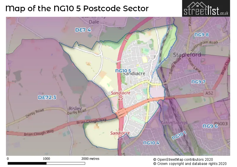
The NG10 5 postcode sector stands on the Derbyshire and Nottinghamshire border.
Did you know? According to the 2021 Census, the NG10 5 postcode sector is home to a bustling 9,135 residents!
Given that each sector allows for 400 unique postcode combinations. Letters C, I, K, M, O and V are not allowed in the last two letters of a postcode. With 211 postcodes already in use, this leaves 189 units available.
The NG10 5 postal code covers the settlement of Sandiacre.
The NG10 5 Postcode shares a border with NG9 7 (Stapleford), NG10 1 (Long Eaton), NG10 4 (Long Eaton), DE7 4 (ILKESTON, Stanton-by-Dale, Quarry Hill Industrial Estate), DE72 3 (Borrowash, Breaston, Draycott) and NG9 8 (Stapleford).
The sector is within the post town of NOTTINGHAM.
NG10 5 is a postcode sector within the NG10 postcode district which is within the NG Nottingham postcode area.
The Royal Mail delivery office for the NG10 5 postal sector is the Long Eaton Delivery Office.
The area of the NG10 5 postcode sector is 1.93 square miles which is 5.01 square kilometres or 1,237.72 square acres.
The NG10 5 postcode sector is crossed by the M1 motorway.
The NG10 5 postcode sector is crossed by the A52 Major A road.
Waterways within the NG10 5 postcode sector include the Erewash Canal, River Erewash.

Map of the NG10 5 Postcode Sector
Explore the NG10 5 postcode sector by using our free interactive map.
| N | G | 1 | 0 | - | 5 | X | X |
| N | G | 1 | 0 | Space | 5 | Letter | Letter |
Official List of Streets
Sandiacre (143 Streets)
Unofficial Streets or Alternative Spellings
Weather Forecast for NG10 5
Press Button to Show Forecast for Stapleford
| Time Period | Icon | Description | Temperature | Rain Probability | Wind |
|---|---|---|---|---|---|
| 18:00 to 21:00 | Cloudy | 9.0°C (feels like 8.0°C) | 4.00% | NE 4 mph | |
| 21:00 to 00:00 | Cloudy | 7.0°C (feels like 6.0°C) | 7.00% | SSE 4 mph |
Press Button to Show Forecast for Stapleford
| Time Period | Icon | Description | Temperature | Rain Probability | Wind |
|---|---|---|---|---|---|
| 00:00 to 03:00 | Partly cloudy (night) | 5.0°C (feels like 3.0°C) | 0.00% | SSW 4 mph | |
| 03:00 to 06:00 | Cloudy | 3.0°C (feels like 1.0°C) | 3.00% | WSW 7 mph | |
| 06:00 to 09:00 | Cloudy | 4.0°C (feels like 1.0°C) | 48.00% | W 9 mph | |
| 09:00 to 12:00 | Cloudy | 7.0°C (feels like 4.0°C) | 44.00% | W 9 mph | |
| 12:00 to 15:00 | Overcast | 8.0°C (feels like 5.0°C) | 17.00% | N 9 mph | |
| 15:00 to 18:00 | Cloudy | 8.0°C (feels like 7.0°C) | 12.00% | NNE 7 mph | |
| 18:00 to 21:00 | Cloudy | 8.0°C (feels like 7.0°C) | 6.00% | ENE 7 mph | |
| 21:00 to 00:00 | Cloudy | 5.0°C (feels like 4.0°C) | 7.00% | E 4 mph |
Press Button to Show Forecast for Stapleford
| Time Period | Icon | Description | Temperature | Rain Probability | Wind |
|---|---|---|---|---|---|
| 00:00 to 03:00 | Partly cloudy (night) | 4.0°C (feels like 2.0°C) | 1.00% | ENE 4 mph | |
| 03:00 to 06:00 | Partly cloudy (night) | 2.0°C (feels like 1.0°C) | 1.00% | NNE 4 mph | |
| 06:00 to 09:00 | Partly cloudy (day) | 3.0°C (feels like 1.0°C) | 1.00% | NNE 4 mph | |
| 09:00 to 12:00 | Cloudy | 7.0°C (feels like 5.0°C) | 4.00% | ENE 7 mph | |
| 12:00 to 15:00 | Overcast | 9.0°C (feels like 8.0°C) | 9.00% | ENE 4 mph | |
| 15:00 to 18:00 | Cloudy | 9.0°C (feels like 9.0°C) | 8.00% | ENE 4 mph | |
| 18:00 to 21:00 | Cloudy | 8.0°C (feels like 6.0°C) | 11.00% | ENE 9 mph | |
| 21:00 to 00:00 | Cloudy | 6.0°C (feels like 4.0°C) | 10.00% | ENE 7 mph |
Press Button to Show Forecast for Stapleford
| Time Period | Icon | Description | Temperature | Rain Probability | Wind |
|---|---|---|---|---|---|
| 00:00 to 03:00 | Partly cloudy (night) | 4.0°C (feels like 2.0°C) | 8.00% | NE 4 mph | |
| 03:00 to 06:00 | Cloudy | 4.0°C (feels like 1.0°C) | 11.00% | NE 7 mph | |
| 06:00 to 09:00 | Cloudy | 4.0°C (feels like 1.0°C) | 10.00% | NE 7 mph | |
| 09:00 to 12:00 | Cloudy | 8.0°C (feels like 5.0°C) | 12.00% | ENE 9 mph | |
| 12:00 to 15:00 | Overcast | 9.0°C (feels like 7.0°C) | 21.00% | ENE 9 mph | |
| 15:00 to 18:00 | Overcast | 11.0°C (feels like 8.0°C) | 21.00% | ENE 11 mph | |
| 18:00 to 21:00 | Cloudy | 9.0°C (feels like 7.0°C) | 19.00% | ENE 11 mph | |
| 21:00 to 00:00 | Cloudy | 7.0°C (feels like 4.0°C) | 15.00% | NE 11 mph |
Press Button to Show Forecast for Stapleford
| Time Period | Icon | Description | Temperature | Rain Probability | Wind |
|---|---|---|---|---|---|
| 00:00 to 03:00 | Overcast | 7.0°C (feels like 4.0°C) | 21.00% | NE 11 mph | |
| 03:00 to 06:00 | Light rain | 7.0°C (feels like 3.0°C) | 52.00% | NNE 13 mph | |
| 06:00 to 09:00 | Heavy rain | 7.0°C (feels like 4.0°C) | 77.00% | NNE 13 mph | |
| 09:00 to 12:00 | Heavy rain | 8.0°C (feels like 5.0°C) | 78.00% | NE 13 mph | |
| 12:00 to 15:00 | Heavy rain | 10.0°C (feels like 7.0°C) | 77.00% | N 13 mph | |
| 15:00 to 18:00 | Light rain shower (day) | 10.0°C (feels like 8.0°C) | 42.00% | N 11 mph | |
| 18:00 to 21:00 | Light rain | 10.0°C (feels like 8.0°C) | 50.00% | NNE 9 mph | |
| 21:00 to 00:00 | Cloudy | 8.0°C (feels like 7.0°C) | 11.00% | SW 7 mph |
Schools and Places of Education Within the NG10 5 Postcode Sector
Cloudside Academy
Academy sponsor led
Stanton Road, Nottingham, Nottinghamshire, NG10 5DE
Head: Miss Jodie Milson
Ofsted Rating: Good
Inspection: 2022-01-12 (833 days ago)
Website: Visit Cloudside Academy Website
Phone: 01159392263
Number of Pupils: 269
Friesland School
Academy converter
Nursery Avenue, Sandiacre, Nottinghamshire, NG10 5AF
Head: Mr Craig Patterson
Ofsted Rating: Good
Inspection: 2023-11-22 (154 days ago)
Website: Visit Friesland School Website
Phone: 01159397326
Number of Pupils: 1279
Ladycross Infant School
Community school
Victoria Road, Nottingham, Nottinghamshire, NG10 5JD
Head: Mrs Kathryn McKinley
Ofsted Rating: Requires improvement
Inspection: 2022-05-11 (714 days ago)
Website: Visit Ladycross Infant School Website
Phone: 01159397379
Number of Pupils: 239
House Prices in the NG10 5 Postcode Sector
| Type of Property | 2018 Average | 2018 Sales | 2017 Average | 2017 Sales | 2016 Average | 2016 Sales | 2015 Average | 2015 Sales |
|---|---|---|---|---|---|---|---|---|
| Detached | £259,402 | 53 | £237,290 | 42 | £215,712 | 47 | £236,957 | 60 |
| Semi-Detached | £156,404 | 73 | £150,391 | 58 | £130,958 | 77 | £136,781 | 79 |
| Terraced | £137,503 | 46 | £130,648 | 31 | £118,074 | 45 | £122,419 | 51 |
| Flats | £103,468 | 16 | £120,600 | 15 | £104,182 | 11 | £105,788 | 12 |
Important Postcodes NG10 5 in the Postcode Sector
NG10 5AE is the postcode for Sandiacre Friesland Sports Centre, Nursery Avenue, Sandiacre, and Sandiacre Friesland Sports Centre, Nursery Avenue
NG10 5AF is the postcode for BLOCK 2, Friesland School, Nursery Avenue, BLOCK 1, Friesland School, Nursery Avenue, BLOCK 3, Friesland School, Nursery Avenue, PERFORMING ARTS BUILDING, Friesland School, Nursery Avenue, and MUSIC, LANGUAGE & ADMIN BLOCK, Friesland School, Nursery Avenue
NG10 5DE is the postcode for Cloudside Junior School, Stanton Road, Sandiacre, Cloudside Academy, Stanton Road, Sandiacre, and Cloudside Junior School, Stanton Road
NG10 5FJ is the postcode for Derbyshire County Council, Sandiacre Library, Doncaster Avenue
NG10 5GF is the postcode for Ladycross House HOP, Travers Road, Ladycross House HOP, Travers Road, Sandiacre, and Main Building, Ladycross House HOP, Travers Road
NG10 5JD is the postcode for MAIN BUILDING, Ladycross Infant School, Victoria Road
NG10 5QG is the postcode for Octavia House, Interchange 25 Business Park, Bostocks Lane
| The NG10 5 Sector is within these Local Authorities |
|
|---|---|
| The NG10 5 Sector is within these Counties |
|
| The NG10 5 Sector is within these Water Company Areas |
|