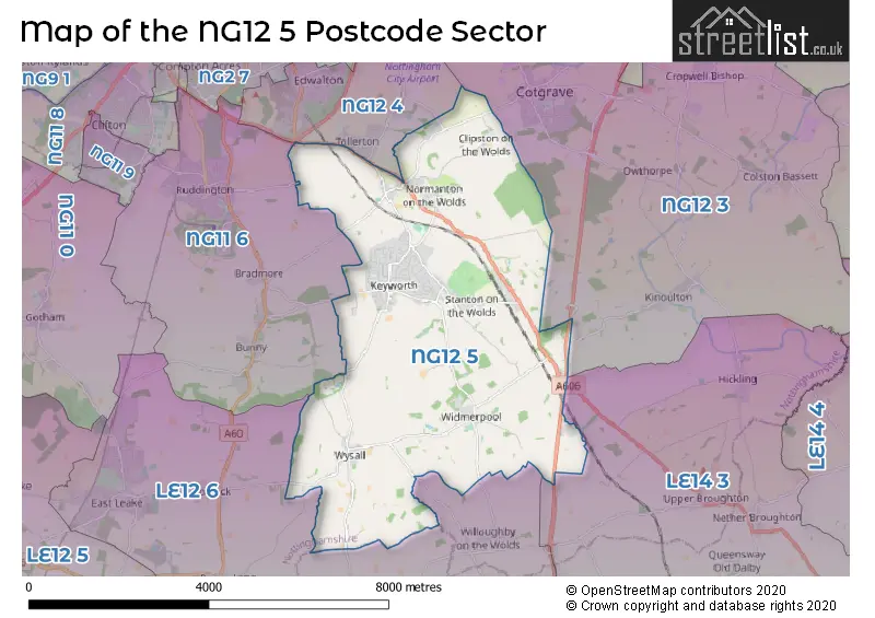
The NG12 5 postcode sector stands on the Leicestershire and Nottinghamshire border.
Did you know? According to the 2021 Census, the NG12 5 postcode sector is home to a bustling 8,590 residents!
Given that each sector allows for 400 unique postcode combinations. Letters C, I, K, M, O and V are not allowed in the last two letters of a postcode. With 250 postcodes already in use, this leaves 150 units available.
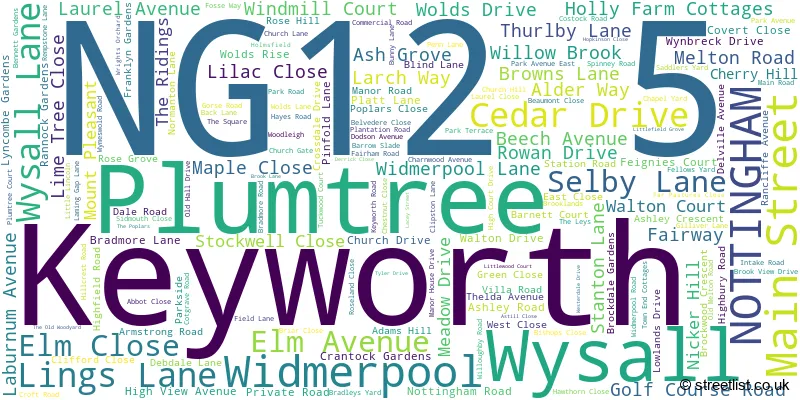
The largest settlement in the NG12 5 postal code is Keyworth followed by Wysall, and Widmerpool.
The NG12 5 Postcode shares a border with NG11 6 (Ruddington, Bunny, Bradmore), NG12 3 (Cotgrave, Cropwell Bishop, Kinoulton), NG12 4 (Edwalton, Tollerton), LE12 6 (East Leake, Wymeswold, Costock) and LE14 3 (Asfordby, Old Dalby, Asfordby Hill).
The sector is within the post town of NOTTINGHAM.
NG12 5 is a postcode sector within the NG12 postcode district which is within the NG Nottingham postcode area.
The Royal Mail delivery office for the NG12 5 postal sector is the Keyworth Scale Payment Delivery Office.
The area of the NG12 5 postcode sector is 16.75 square miles which is 43.37 square kilometres or 10,717.12 square acres.
The NG12 5 postcode sector is crossed by the A46 Major A road.
The NG12 5 postcode sector is crossed by the A52 Major A road.
Waterways within the NG12 5 postcode sector include the Fairham Brook, Thurbeck Dyke.

Map of the NG12 5 Postcode Sector
Explore the NG12 5 postcode sector by using our free interactive map.
| N | G | 1 | 2 | - | 5 | X | X |
| N | G | 1 | 2 | Space | 5 | Letter | Letter |
Official List of Streets
Keyworth (132 Streets)
Plumtree (11 Streets)
Wysall (13 Streets)
Widmerpool (15 Streets)
Unofficial Streets or Alternative Spellings
Willoughby On The Wolds
WIDMERPOOL LANEWymeswold
WYSALL LANEKinoulton
KINOULTON LANEKeyworth
FEIGNIES COURT HOLLY FARM COTTAGES PRIVATE ROAD WOODLEIGHTollerton
BENTINCK AVENUE COTGRAVE LANE LENTON AVENUE STANSTEAD AVENUE TOLLERTON LANEHickling Pastures
MELTON ROADEdwalton
MELTON ROADCotgrave
PLUMTREE ROADBunny
KEYWORTH LANERuddington
FLAWFORTH LANEWeather Forecast for NG12 5
Press Button to Show Forecast for Edwalton
| Time Period | Icon | Description | Temperature | Rain Probability | Wind |
|---|---|---|---|---|---|
| 06:00 to 09:00 | Sunny day | 5.0°C (feels like 1.0°C) | 0.00% | NNW 9 mph | |
| 09:00 to 12:00 | Cloudy | 7.0°C (feels like 4.0°C) | 7.00% | N 13 mph | |
| 12:00 to 15:00 | Cloudy | 9.0°C (feels like 6.0°C) | 5.00% | N 11 mph | |
| 15:00 to 18:00 | Cloudy | 10.0°C (feels like 7.0°C) | 5.00% | N 9 mph | |
| 18:00 to 21:00 | Cloudy | 9.0°C (feels like 7.0°C) | 3.00% | NNE 7 mph | |
| 21:00 to 00:00 | Cloudy | 6.0°C (feels like 5.0°C) | 4.00% | E 4 mph |
Press Button to Show Forecast for Edwalton
| Time Period | Icon | Description | Temperature | Rain Probability | Wind |
|---|---|---|---|---|---|
| 00:00 to 03:00 | Cloudy | 4.0°C (feels like 2.0°C) | 4.00% | WSW 4 mph | |
| 03:00 to 06:00 | Partly cloudy (night) | 4.0°C (feels like 1.0°C) | 1.00% | WSW 7 mph | |
| 06:00 to 09:00 | Cloudy | 5.0°C (feels like 2.0°C) | 5.00% | W 9 mph | |
| 09:00 to 12:00 | Partly cloudy (day) | 8.0°C (feels like 5.0°C) | 6.00% | WNW 11 mph | |
| 12:00 to 15:00 | Cloudy | 10.0°C (feels like 8.0°C) | 9.00% | NW 9 mph | |
| 15:00 to 18:00 | Cloudy | 10.0°C (feels like 8.0°C) | 9.00% | N 9 mph | |
| 18:00 to 21:00 | Cloudy | 8.0°C (feels like 7.0°C) | 8.00% | NNE 7 mph | |
| 21:00 to 00:00 | Cloudy | 6.0°C (feels like 4.0°C) | 4.00% | NNE 4 mph |
Press Button to Show Forecast for Edwalton
| Time Period | Icon | Description | Temperature | Rain Probability | Wind |
|---|---|---|---|---|---|
| 00:00 to 03:00 | Cloudy | 4.0°C (feels like 2.0°C) | 6.00% | NE 4 mph | |
| 03:00 to 06:00 | Cloudy | 3.0°C (feels like 1.0°C) | 5.00% | NE 4 mph | |
| 06:00 to 09:00 | Cloudy | 4.0°C (feels like 2.0°C) | 6.00% | NE 4 mph | |
| 09:00 to 12:00 | Cloudy | 7.0°C (feels like 5.0°C) | 7.00% | E 7 mph | |
| 12:00 to 15:00 | Overcast | 9.0°C (feels like 8.0°C) | 13.00% | ESE 7 mph | |
| 15:00 to 18:00 | Cloudy | 10.0°C (feels like 8.0°C) | 12.00% | E 7 mph | |
| 18:00 to 21:00 | Cloudy | 9.0°C (feels like 7.0°C) | 10.00% | E 9 mph | |
| 21:00 to 00:00 | Cloudy | 7.0°C (feels like 4.0°C) | 11.00% | ENE 9 mph |
Press Button to Show Forecast for Edwalton
| Time Period | Icon | Description | Temperature | Rain Probability | Wind |
|---|---|---|---|---|---|
| 00:00 to 03:00 | Cloudy | 6.0°C (feels like 4.0°C) | 14.00% | E 7 mph | |
| 03:00 to 06:00 | Cloudy | 5.0°C (feels like 3.0°C) | 15.00% | E 7 mph | |
| 06:00 to 09:00 | Overcast | 6.0°C (feels like 4.0°C) | 17.00% | ENE 7 mph | |
| 09:00 to 12:00 | Overcast | 9.0°C (feels like 6.0°C) | 16.00% | ENE 9 mph | |
| 12:00 to 15:00 | Cloudy | 11.0°C (feels like 9.0°C) | 15.00% | E 9 mph | |
| 15:00 to 18:00 | Light rain | 12.0°C (feels like 10.0°C) | 44.00% | E 9 mph | |
| 18:00 to 21:00 | Cloudy | 11.0°C (feels like 9.0°C) | 15.00% | ENE 9 mph | |
| 21:00 to 00:00 | Cloudy | 9.0°C (feels like 6.0°C) | 14.00% | ENE 9 mph |
Schools and Places of Education Within the NG12 5 Postcode Sector
Crossdale Primary School
Academy converter
Crossdale Drive, Nottingham, Nottinghamshire, NG12 5HP
Head: Mr P Cresswell
Ofsted Rating: Good
Inspection: 2019-11-27 (1610 days ago)
Website: Visit Crossdale Primary School Website
Phone: 01159748088
Number of Pupils: 191
Keyworth Primary and Nursery School
Academy converter
Nottingham Road, Nottingham, Nottinghamshire, NG12 5FB
Head: Mr Peter Cresswell
Ofsted Rating: Good
Inspection: 2019-10-15 (1653 days ago)
Website: Visit Keyworth Primary and Nursery School Website
Phone: 01159748005
Number of Pupils: 170
The South Wolds Academy & Sixth Form
Academy converter
Church Drive, Nottingham, Nottinghamshire, NG12 5FF
Head: Mrs Halina Angus
Ofsted Rating: Good
Inspection: 2019-12-05 (1602 days ago)
Website: Visit The South Wolds Academy & Sixth Form Website
Phone: 01159373506
Number of Pupils: 976
Willow Brook Primary School
Community school
Willow Brook, Nottingham, Nottinghamshire, NG12 5BB
Head: Louise Ballard
Ofsted Rating: Good
Inspection: 2023-06-28 (301 days ago)
Website: Visit Willow Brook Primary School Website
Phone: 01159149889
Number of Pupils: 203
House Prices in the NG12 5 Postcode Sector
| Type of Property | 2018 Average | 2018 Sales | 2017 Average | 2017 Sales | 2016 Average | 2016 Sales | 2015 Average | 2015 Sales |
|---|---|---|---|---|---|---|---|---|
| Detached | £436,959 | 76 | £371,588 | 71 | £386,647 | 72 | £340,619 | 90 |
| Semi-Detached | £209,849 | 56 | £209,442 | 52 | £186,011 | 45 | £184,884 | 44 |
| Terraced | £237,955 | 11 | £151,700 | 25 | £195,546 | 24 | £150,420 | 35 |
| Flats | £232,590 | 5 | £225,313 | 4 | £0 | 0 | £285,833 | 3 |
Important Postcodes NG12 5 in the Postcode Sector
NG12 5BB is the postcode for Willow Brook Primary School, Willow Brook, Keyworth, and Willow Brook Primary School, Willow Brook
NG12 5FB is the postcode for KEYWORTH PRIMARY AND NURSERY SCHOOL, NOTTINGHAM ROAD, KEYWORTH, Keyworth Primary & Nursery School, Nottingham Road, and Keyworth Primary & Nursery School, Nottingham Road, Keyworth
NG12 5FF is the postcode for MAIN SCHOOL, South Wolds Academy, Church Drive, Nottinghamshire County Council, Library, Church Drive, LOWER SCHOOL, South Wolds Academy, Church Drive, and Keyworth Leisure Centre, Church Drive
NG12 5GG is the postcode for Staff Restaurant and Meeting Rooms 1-4 ( M Block), British Geological Survey, Nicker Hill, James Hutton Building, British Geological Survey, Nicker Hill, TECHNICAL ENGINEERING & CENTRAL STORES (Q BLOCK), British Geological Survey, Environmental Science Centre, MAIN BUILDING, British Geological Survey, Nicker Hill, MAIN BUILDING INC: J,K,P,U,W BLOCKS, KDB, WSB & NGR, British Geological Survey, Environmental Science Centre, British Geological Survey, Nicker Hill, TECHNICAL ENGINEERING (Q) & ST1 (Q1), British Geological Survey, Environmental Science Centre, STAFF RESTAURANT & MEETING ROOMS 1-4 ( M BLOCK), British Geological Survey, Environmental Science Centre, Q BLOCK, British Geological Survey, Nicker Hill, V BLOCK, British Geological Survey, Nicker Hill, JAMES HUTTON BUILDING BRITISH GEOLOGICAL SURVEY, British Geological Survey, Nicker Hill, BLOCK M/STAFF RESTAURANT AND MEETING ROOMS 1-4, British Geological Survey, Nicker Hill, JAMES HUTTON BUILDING, British Geological Survey, Environmental Science Centre, PUBLICATION STORE (V BLOCK), British Geological Survey, Environmental Science Centre, Main Building (Inc: J,K,P,U,W Blocks, KDB, WSB & NGR), British Geological Survey, Nicker Hill, Publication Stores (V Block), British Geological Survey, Nicker Hill, M BLOCK, British Geological Survey, Nicker Hill, and Technical Engineering & Central Stores (Q Block), British Geological Survey, Nicker Hill
NG12 5HP is the postcode for CROSSDALE DRIVE PRIMARY SCHOOL, CROSSDALE DRIVE, KEYWORTH, and Crossdale Drive Primary School, Crossdale Drive
NG12 5JU is the postcode for Keyworth Health Centre, Bunny Lane, Keyworth, and Keyworth Health Centre, Bunny Lane
| The NG12 5 Sector is within these Local Authorities |
|
|---|---|
| The NG12 5 Sector is within these Counties |
|
| The NG12 5 Sector is within these Water Company Areas |
|