The NG13 8 postcode sector is within the county of Nottinghamshire.
Did you know? According to the 2021 Census, the NG13 8 postcode sector is home to a bustling 12,747 residents!
Given that each sector allows for 400 unique postcode combinations. Letters C, I, K, M, O and V are not allowed in the last two letters of a postcode. With 324 postcodes already in use, this leaves 76 units available.
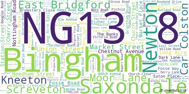
The largest settlement in the NG13 8 postal code is Bingham followed by East Bridgford, and Newton.
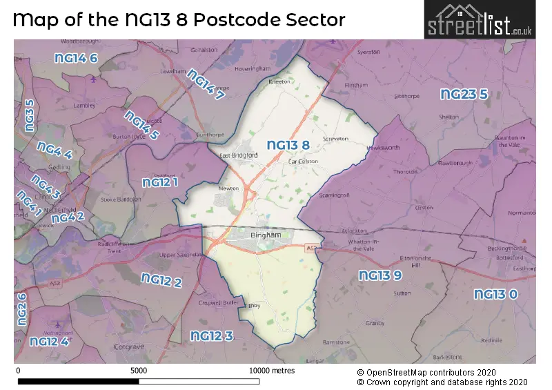
The NG13 8 Postcode shares a border with NG12 1 (Radcliffe-on-Trent, Shelford), NG12 2 (Radcliffe-on-Trent, Holme Pierrepont), NG12 3 (Cotgrave, Cropwell Bishop, Kinoulton), NG13 9 (Whatton, Aslockton, Langar), NG14 7 (Lowdham, Bleasby, Gunthorpe) and NG23 5 (Long Bennington, Claypole, Elston).
The sector is within the post town of NOTTINGHAM.
NG13 8 is a postcode sector within the NG13 postcode district which is within the NG Nottingham postcode area.
The Royal Mail delivery office for the NG13 8 postal sector is the Bingham Scale Payment Delivery Office.
The area of the NG13 8 postcode sector is 18.94 square miles which is 49.04 square kilometres or 12,119.06 square acres.
The NG13 8 postcode sector is crossed by the A46 Major A road.
The NG13 8 postcode sector is crossed by the A52 Major A road.
Waterways within the NG13 8 postcode sector include the Shacker Dale, Car Dyke, Smite, River Trent.

Map of the NG13 8 Postcode Sector
Explore the NG13 8 postcode sector by using our free interactive map.
| N | G | 1 | 3 | - | 8 | X | X |
| N | G | 1 | 3 | Space | 8 | Letter | Letter |
Official List of Streets
Bingham (189 Streets)
Newton (19 Streets)
East Bridgford (47 Streets)
Screveton (7 Streets)
Car Colston (6 Streets)
Kneeton (4 Streets)
Unofficial Streets or Alternative Spellings
Flintham
SPRING LANE BAXTER CLOSE BINGHAM INTERCHANGE BINGHAM LINEAR PARK BRAITHWAITE ROAD BRIDGFORD COURT BRIDGFORD ROAD BRIDGFORD STREET BURROWS DRIVE BUTTS FIELD BYE PASS ROAD CABOURN DRIVE COWDELL GROVE DUNSMORE AVENUE EAST BRIDGFORD ROAD FEWSTER GARDENS FOSS WAY FP23 GRANBY LANE GREEN COURT GUNTHORPE BRIDGE HACKETT GARDENS HARRIS ROAD HASSALL COURT HENSHAW DRIVE HICKMAN ROAD HIND CLOSE JOHNSON ROAD KEILDER DRIVE KETTLEBAND CLOSE KIRKHILL KIRKHILL COTTAGES LOCKDOWN LANE MARGIDINUM MARRIOTT STREET MEADOW LANE MOORBRIDGE COURT NEW LANE OLD POST OFFICE YARD OLDHILL LANE PENSON GARDENS RED LODGE LANE SAXONDALE ROUNDABOUT SQUIRES GROVE STATES AVENUE SWINLEY COURT THE GREEN THORNTON MEWS WARD ROAD WEIGHBRIDGE WELLINGTON AVENUE WIDNALL DRIVE WILFORD AVENUEAslockton
GRANTHAM ROAD NEW LANEBingham
LINLEY COURT OLD MILL COURTCropwell Butler
TITHBY ROADRadcliffe-on-Trent
OATFIELD LANELangar
BINGHAM ROADWeather Forecast for NG13 8
Press Button to Show Forecast for Bingham
| Time Period | Icon | Description | Temperature | Rain Probability | Wind |
|---|---|---|---|---|---|
| 18:00 to 21:00 | Partly cloudy (day) | 8.0°C (feels like 7.0°C) | 2.00% | NE 4 mph | |
| 21:00 to 00:00 | Partly cloudy (night) | 4.0°C (feels like 3.0°C) | 2.00% | ENE 4 mph |
Press Button to Show Forecast for Bingham
| Time Period | Icon | Description | Temperature | Rain Probability | Wind |
|---|---|---|---|---|---|
| 00:00 to 03:00 | Partly cloudy (night) | 2.0°C (feels like 0.0°C) | 1.00% | NE 4 mph | |
| 03:00 to 06:00 | Clear night | 1.0°C (feels like -1.0°C) | 1.00% | N 4 mph | |
| 06:00 to 09:00 | Sunny day | 2.0°C (feels like 0.0°C) | 1.00% | N 4 mph | |
| 09:00 to 12:00 | Sunny day | 7.0°C (feels like 5.0°C) | 2.00% | NE 7 mph | |
| 12:00 to 15:00 | Cloudy | 9.0°C (feels like 9.0°C) | 10.00% | ENE 4 mph | |
| 15:00 to 18:00 | Cloudy | 10.0°C (feels like 9.0°C) | 8.00% | ENE 4 mph | |
| 18:00 to 21:00 | Cloudy | 8.0°C (feels like 6.0°C) | 11.00% | ENE 4 mph | |
| 21:00 to 00:00 | Cloudy | 5.0°C (feels like 3.0°C) | 11.00% | ENE 7 mph |
Press Button to Show Forecast for Bingham
| Time Period | Icon | Description | Temperature | Rain Probability | Wind |
|---|---|---|---|---|---|
| 00:00 to 03:00 | Cloudy | 4.0°C (feels like 2.0°C) | 9.00% | NE 4 mph | |
| 03:00 to 06:00 | Cloudy | 3.0°C (feels like 1.0°C) | 11.00% | NE 4 mph | |
| 06:00 to 09:00 | Cloudy | 4.0°C (feels like 1.0°C) | 10.00% | NE 7 mph | |
| 09:00 to 12:00 | Cloudy | 8.0°C (feels like 6.0°C) | 13.00% | ENE 9 mph | |
| 12:00 to 15:00 | Overcast | 10.0°C (feels like 7.0°C) | 21.00% | ENE 9 mph | |
| 15:00 to 18:00 | Overcast | 11.0°C (feels like 9.0°C) | 22.00% | ENE 11 mph | |
| 18:00 to 21:00 | Cloudy | 9.0°C (feels like 7.0°C) | 16.00% | ENE 11 mph | |
| 21:00 to 00:00 | Cloudy | 7.0°C (feels like 4.0°C) | 15.00% | NE 11 mph |
Press Button to Show Forecast for Bingham
| Time Period | Icon | Description | Temperature | Rain Probability | Wind |
|---|---|---|---|---|---|
| 00:00 to 03:00 | Light rain | 7.0°C (feels like 4.0°C) | 48.00% | NE 11 mph | |
| 03:00 to 06:00 | Light rain | 7.0°C (feels like 4.0°C) | 51.00% | NNE 13 mph | |
| 06:00 to 09:00 | Heavy rain | 7.0°C (feels like 4.0°C) | 76.00% | NNE 13 mph | |
| 09:00 to 12:00 | Heavy rain | 9.0°C (feels like 6.0°C) | 76.00% | NNE 13 mph | |
| 12:00 to 15:00 | Heavy rain | 10.0°C (feels like 8.0°C) | 74.00% | NE 11 mph | |
| 15:00 to 18:00 | Heavy rain | 11.0°C (feels like 8.0°C) | 75.00% | NE 11 mph | |
| 18:00 to 21:00 | Light rain shower (day) | 10.0°C (feels like 7.0°C) | 37.00% | NNE 9 mph | |
| 21:00 to 00:00 | Cloudy | 8.0°C (feels like 6.0°C) | 10.00% | SW 7 mph |
Schools and Places of Education Within the NG13 8 Postcode Sector
Carnarvon Primary School
Community school
Nursery Road, Nottingham, Nottinghamshire, NG13 8EH
Head: Mr Andrew Board
Ofsted Rating: Good
Inspection: 2022-12-01 (511 days ago)
Website: Visit Carnarvon Primary School Website
Phone: 01949838246
Number of Pupils: 475
East Bridgford St Peters Church of England Academy
Academy converter
Kneeton Road, Nottingham, Nottinghamshire, NG13 8PG
Head: Mr Richard Tomlinson
Ofsted Rating: Good
Inspection: 2022-04-22 (734 days ago)
Website: Visit East Bridgford St Peters Church of England Academy Website
Phone: 0194920226
Number of Pupils: 283
Robert Miles Infant School
Academy converter
School Lane, Nottingham, Nottinghamshire, NG13 8FE
Head: Mrs Sonja Adams
Ofsted Rating: Good
Inspection: 2022-03-16 (771 days ago)
Website: Visit Robert Miles Infant School Website
Phone: 01949837422
Number of Pupils: 146
Robert Miles Junior School
Academy converter
Market Place, Nottingham, Nottinghamshire, NG13 8AP
Head: Mr James Evelyn
Ofsted Rating: Good
Inspection: 2019-03-19 (1864 days ago)
Website: Visit Robert Miles Junior School Website
Phone: 01949875011
Number of Pupils: 251
Toot Hill School
Academy converter
The Banks, Nottingham, Nottinghamshire, NG13 8BL
Head: Dr Chris Eardley
Ofsted Rating: Good
Inspection: 2022-11-09 (533 days ago)
Website: Visit Toot Hill School Website
Phone: 01949875550
Number of Pupils: 1898
House Prices in the NG13 8 Postcode Sector
| Type of Property | 2018 Average | 2018 Sales | 2017 Average | 2017 Sales | 2016 Average | 2016 Sales | 2015 Average | 2015 Sales |
|---|---|---|---|---|---|---|---|---|
| Detached | £320,900 | 116 | £311,429 | 119 | £306,153 | 143 | £288,673 | 113 |
| Semi-Detached | £206,220 | 51 | £217,959 | 55 | £203,026 | 59 | £194,389 | 55 |
| Terraced | £179,384 | 43 | £196,678 | 46 | £170,081 | 55 | £158,021 | 43 |
| Flats | £126,024 | 17 | £123,071 | 17 | £123,644 | 24 | £106,228 | 23 |
Important Postcodes NG13 8 in the Postcode Sector
NG13 8AP is the postcode for Robert Miles Junior School, 20 Market Place, Robert Miles Junior School, Market Place, and ROBERT MILES JUNIOR SCHOOL, MARKET PLACE, BINGHAM
NG13 8AS is the postcode for Rushcliffe Day Service, Moor Lane
NG13 8BL is the postcode for BUSINESS STUDIES, Toot Hill Comprehensive School, The Banks, SIXTH FORM, Toot Hill Comprehensive School, The Banks, DESIGN & TECHNOLOGY BLOCK MODULAR BUILDING, Toot Hill Comprehensive School, The Banks, Bingham Leisure Centre, The Banks, MAIN SCHOOL BUILDING, Toot Hill Comprehensive School, The Banks, Bingham Leisure Centre, The Banks, Bingham, TOOT HILL COMPREHENSIVE SCHOOL, THE BANKS, and BUILDING 2, Toot Hill Comprehensive School, The Banks
NG13 8EH is the postcode for PV BUILDING, Carnarvon Primary School, Nursery Road, Carnarvon Primary School, Nursery Road, Bingham, and Carnarvon Primary School, Nursery Road
NG13 8FE is the postcode for Robert Miles Infant School, School Lane, Bingham, and Robert Miles Infant School, School Lane
NG13 8NY is the postcode for EAST BRIDGFORD MEDICAL CENTRE, 2 BUTT LANE, EAST BRIDGFORD
NG13 8PG is the postcode for East Bridgford St Peter's CofE Academy, Kneeton Road, Old Building, East Bridgford St Peter's CofE Academy, Kneeton Road, and St. Peters C of E Primary School, Kneeton Road
NG13 8TE is the postcode for Wynhill Lodge, 3-5 Wynhill Court
| The NG13 8 Sector is within these Local Authorities |
|
|---|---|
| The NG13 8 Sector is within these Counties |
|
| The NG13 8 Sector is within these Water Company Areas |
|