The NG14 postcode district is a postal district located in the NG Nottingham postcode area with a population of 19,983 residents according to the 2021 England and Wales Census.
The area of the NG14 postcode district is 32.13 square miles which is 83.21 square kilometres or 20,562.48 acres.
Currently, the NG14 district has about 551 postcode units spread across 3 geographic postcode sectors.
Given that each sector allows for 400 unique postcode combinations, the district has a capacity of 1,200 postcodes. With 551 postcodes already in use, this leaves 649 units available.
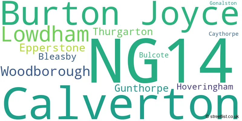
The largest settlement in the NG14 postal code is Calverton followed by Burton Joyce, and Lowdham.
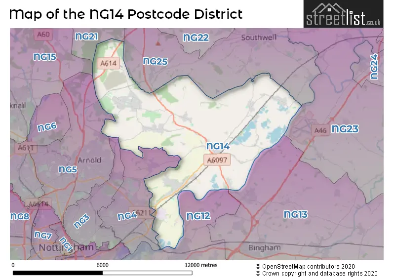
The NG14 Postcode shares a border with NG21 (Rainworth, Edwinstowe, Clipstone Village), NG25 (SOUTHWELL, Fiskerton, Oxton), NG3 (NOTTINGHAM, Mapperley), NG4 (Carlton, Gedling, Netherfield), NG12 (Radcliffe-on-Trent, Keyworth, Cotgrave), NG13 (Bingham, Bottesford, East Bridgford) and NG5 (NOTTINGHAM, Arnold, Woodthorpe).
The primary settlement in the NG14 postcode district is Burton Joyce, located in the county of Nottinghamshire, England. Other significant settlements in the district include Calverton, Epperstone, Woodborough, Bleasby, Caythorpe, Gonalston, Gunthorpe, Hoveringham, and Lowdham. The main post town in the district is Nottingham.
For the district NG14, we have data on 3 postcode sectors. Here's a breakdown: The sector NG14 5, covers Burton Joyce in Nottinghamshire. The sector NG14 6, covers Calverton and Woodborough and Epperstone in Nottinghamshire. The sector NG14 7, covers Lowdham and Gunthorpe and Thurgarton and Bleasby in Nottinghamshire.

Map of the NG14 Postcode District
Explore the NG14 postcode district by using our free interactive map.
When it comes to local government, postal geography often disregards political borders. However, for a breakdown in the NG14 District: the district mostly encompasses the Gedling District (B) (375 postcodes), and finally, the Newark and Sherwood District area (205 postcodes).
Recent House Sales in NG14
| Date | Price | Address |
|---|---|---|
| 23/10/2023 | £310,000 | Lampwood Close, Calverton, Nottingham, NG14 6JT |
| 25/09/2023 | £450,000 | Pinfold Crescent, Woodborough, Nottingham, NG14 6DQ |
| 22/09/2023 | £425,000 | Orchard Close, Burton Joyce, Nottingham, NG14 5EF |
| 11/09/2023 | £208,000 | Kingfisher Road, Stoke Bardolph, Nottingham, NG14 5HP |
| 08/09/2023 | £112,500 | Shaftesbury Avenue, Burton Joyce, Nottingham, NG14 5GL |
| 08/09/2023 | £625,000 | Criftin Road, Burton Joyce, Nottingham, NG14 5FB |
| 01/09/2023 | £290,000 | Main Street, Epperstone, Nottingham, NG14 6AG |
| 31/08/2023 | £1,425,000 | Bleasby Road, Thurgarton, Nottingham, NG14 7FW |
| 31/08/2023 | £435,000 | Foxhill Road, Burton Joyce, Nottingham, NG14 5DB |
| 30/08/2023 | £380,000 | Georges Lane, Calverton, Nottingham, NG14 6JS |
Weather Forecast for NG14
Press Button to Show Forecast for Carlton (Nottinghamshire)
| Time Period | Icon | Description | Temperature | Rain Probability | Wind |
|---|---|---|---|---|---|
| 15:00 to 18:00 | Cloudy | 8.0°C (feels like 7.0°C) | 9.00% | NNE 4 mph | |
| 18:00 to 21:00 | Partly cloudy (day) | 8.0°C (feels like 7.0°C) | 2.00% | ENE 7 mph | |
| 21:00 to 00:00 | Partly cloudy (night) | 5.0°C (feels like 3.0°C) | 1.00% | ENE 4 mph |
Press Button to Show Forecast for Carlton (Nottinghamshire)
| Time Period | Icon | Description | Temperature | Rain Probability | Wind |
|---|---|---|---|---|---|
| 00:00 to 03:00 | Partly cloudy (night) | 3.0°C (feels like 1.0°C) | 1.00% | NE 4 mph | |
| 03:00 to 06:00 | Clear night | 2.0°C (feels like 0.0°C) | 1.00% | N 4 mph | |
| 06:00 to 09:00 | Sunny day | 3.0°C (feels like 0.0°C) | 1.00% | N 7 mph | |
| 09:00 to 12:00 | Sunny day | 7.0°C (feels like 5.0°C) | 2.00% | NE 7 mph | |
| 12:00 to 15:00 | Overcast | 9.0°C (feels like 9.0°C) | 10.00% | ENE 4 mph | |
| 15:00 to 18:00 | Cloudy | 10.0°C (feels like 9.0°C) | 8.00% | NE 4 mph | |
| 18:00 to 21:00 | Cloudy | 8.0°C (feels like 6.0°C) | 11.00% | ENE 4 mph | |
| 21:00 to 00:00 | Partly cloudy (night) | 5.0°C (feels like 3.0°C) | 8.00% | ENE 7 mph |
Press Button to Show Forecast for Carlton (Nottinghamshire)
| Time Period | Icon | Description | Temperature | Rain Probability | Wind |
|---|---|---|---|---|---|
| 00:00 to 03:00 | Cloudy | 4.0°C (feels like 2.0°C) | 9.00% | NE 4 mph | |
| 03:00 to 06:00 | Cloudy | 3.0°C (feels like 1.0°C) | 11.00% | NE 4 mph | |
| 06:00 to 09:00 | Cloudy | 4.0°C (feels like 1.0°C) | 10.00% | NE 7 mph | |
| 09:00 to 12:00 | Cloudy | 8.0°C (feels like 6.0°C) | 13.00% | ENE 9 mph | |
| 12:00 to 15:00 | Overcast | 10.0°C (feels like 7.0°C) | 21.00% | ENE 9 mph | |
| 15:00 to 18:00 | Overcast | 11.0°C (feels like 9.0°C) | 22.00% | ENE 11 mph | |
| 18:00 to 21:00 | Cloudy | 9.0°C (feels like 7.0°C) | 16.00% | ENE 11 mph | |
| 21:00 to 00:00 | Cloudy | 7.0°C (feels like 4.0°C) | 15.00% | NE 11 mph |
Press Button to Show Forecast for Carlton (Nottinghamshire)
| Time Period | Icon | Description | Temperature | Rain Probability | Wind |
|---|---|---|---|---|---|
| 00:00 to 03:00 | Light rain | 7.0°C (feels like 4.0°C) | 48.00% | NE 11 mph | |
| 03:00 to 06:00 | Light rain | 7.0°C (feels like 4.0°C) | 51.00% | NNE 13 mph | |
| 06:00 to 09:00 | Heavy rain | 7.0°C (feels like 4.0°C) | 76.00% | NNE 13 mph | |
| 09:00 to 12:00 | Heavy rain | 9.0°C (feels like 6.0°C) | 76.00% | NNE 13 mph | |
| 12:00 to 15:00 | Heavy rain | 10.0°C (feels like 8.0°C) | 74.00% | NE 11 mph | |
| 15:00 to 18:00 | Heavy rain | 11.0°C (feels like 8.0°C) | 75.00% | NE 11 mph | |
| 18:00 to 21:00 | Light rain shower (day) | 10.0°C (feels like 7.0°C) | 36.00% | NNE 9 mph | |
| 21:00 to 00:00 | Cloudy | 8.0°C (feels like 6.0°C) | 10.00% | SW 7 mph |
Where is the NG14 Postcode District?
The postcode district NG14 is located in the town of Nottingham. It is near the towns of Southwell, Mansfield, Ilkeston, and Melton Mowbray. Nottingham is approximately 111.37 miles away from the center of London.
The district is within the post town of NOTTINGHAM.
The sector has postcodes within the nation of England.
The NG14 Postcode District is covers the following regions.
- South Nottinghamshire - Derbyshire and Nottinghamshire - East Midlands (England)
- North Nottinghamshire - Derbyshire and Nottinghamshire - East Midlands (England)
| Postcode Sector | Delivery Office |
|---|---|
| NG14 5 | Burton Joyce Scale Payment Delivery Office |
| NG14 6 | Calverton Scale Payment Delivery Office |
| NG14 6 | Woodborough Scale Payment Delivery Office |
| NG14 6 | Carlton (ng) Delivery Office |
| NG14 7 | Carlton (ng) Delivery Office |
| NG14 7 | Lowdham Scale Payment Delivery Office |
| N | G | 1 | 4 | - | X | X | X |
| N | G | 1 | 4 | Space | Numeric | Letter | Letter |
Current Monthly Rental Prices
| # Bedrooms | Min Price | Max Price | Avg Price |
|---|---|---|---|
| 1 | £450 | £1,555 | £1,079 |
| 2 | £795 | £950 | £873 |
| 3 | £1,200 | £2,500 | £1,658 |
| 5 | £2,250 | £2,250 | £2,250 |
Current House Prices
| # Bedrooms | Min Price | Max Price | Avg Price |
|---|---|---|---|
| £175,000 | £1,650,000 | £639,167 | |
| 1 | £239,950 | £250,000 | £244,975 |
| 2 | £130,000 | £395,000 | £253,228 |
| 3 | £90,000 | £695,000 | £313,067 |
| 4 | £220,000 | £1,250,000 | £497,346 |
| 5 | £344,995 | £1,950,000 | £770,239 |
| 6 | £435,000 | £850,000 | £678,333 |
| 7 | £1,275,000 | £1,750,000 | £1,541,667 |
Estate Agents who Operate in the NG14 District
| Logo | Name | Brand Name | Address | Contact Number | Total Properties |
|---|---|---|---|---|---|
 | Burton Joyce | Johnsons and Partners | 111 Church Road, Burton Joyce, Nottingham, NG14 5DJ | 0115 931 2020 | 44 |
 | Nottingham | Lesley Greaves Estate Agents | 20 Main Road, Gedling, Nottingham, NG4 3HP | 0115 987 7337 | 15 |
 | Arnold | David James Estate Agents | 100 Front Street, Arnold, Nottingham, NG5 7EJ | 0115 647 1147 | 9 |
 | Nottinghamshire | Smith & Partners | 16 Market Place, Southwell, NG25 0HE | 01636 556195 | 9 |
 | Cotgrave | Thomas James Estate Agents | Corner Cottage Bingham Road, Cotgrave, NG12 3JR | 0115 647 1698 | 9 |
| Type of Property | 2018 Average | 2018 Sales | 2017 Average | 2017 Sales | 2016 Average | 2016 Sales | 2015 Average | 2015 Sales |
|---|---|---|---|---|---|---|---|---|
| Detached | £360,396 | 177 | £355,954 | 201 | £321,537 | 185 | £333,497 | 208 |
| Semi-Detached | £192,548 | 83 | £176,888 | 86 | £196,213 | 83 | £184,027 | 99 |
| Terraced | £180,686 | 32 | £200,731 | 26 | £159,417 | 36 | £139,934 | 27 |
| Flats | £139,394 | 24 | £148,600 | 10 | £149,519 | 21 | £109,158 | 22 |