The NG14 7 postcode sector is within the county of Nottinghamshire.
Did you know? According to the 2021 Census, the NG14 7 postcode sector is home to a bustling 5,880 residents!
Given that each sector allows for 400 unique postcode combinations. Letters C, I, K, M, O and V are not allowed in the last two letters of a postcode. With 167 postcodes already in use, this leaves 233 units available.
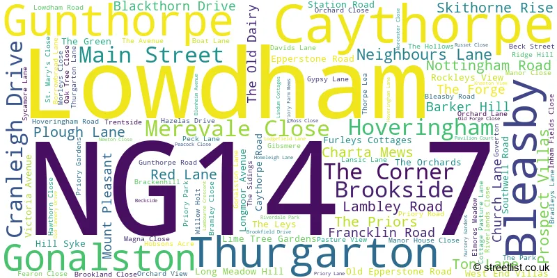
The largest settlement in the NG14 7 postal code is Lowdham followed by Bleasby, and Gunthorpe.
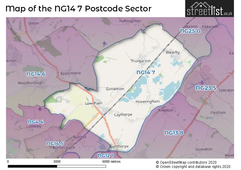
The NG14 7 Postcode shares a border with NG12 1 (Radcliffe-on-Trent, Shelford), NG4 4 (Gedling, Lambley, Carlton), NG13 8 (Bingham, East Bridgford, Newton), NG14 5 (Burton Joyce, Bulcote), NG14 6 (Calverton, Woodborough, Epperstone), NG23 5 (Long Bennington, Claypole, Elston) and NG25 0 (SOUTHWELL, Fiskerton, Oxton).
The sector is within the post town of NOTTINGHAM.
NG14 7 is a postcode sector within the NG14 postcode district which is within the NG Nottingham postcode area.
The Royal Mail delivery office for the NG14 7 postal sector is the Carlton (ng) Delivery Office and Lowdham Scale Payment Delivery Office.
The area of the NG14 7 postcode sector is 13.90 square miles which is 36.00 square kilometres or 8,895.24 square acres.
Waterways within the NG14 7 postcode sector include the River Trent, Dover Beck, Car Dyke, Cocker Beck.

Map of the NG14 7 Postcode Sector
Explore the NG14 7 postcode sector by using our free interactive map.
| N | G | 1 | 4 | - | 7 | X | X |
| N | G | 1 | 4 | Space | 7 | Letter | Letter |
Official List of Streets
Lowdham (53 Streets)
Thurgarton (15 Streets)
Bleasby (13 Streets)
Hoveringham (10 Streets)
Caythorpe (5 Streets)
Gunthorpe (19 Streets)
Gonalston (1 Streets)
Unofficial Streets or Alternative Spellings
Thurgarton
MAIN STREETLowdham
NEIGHBOURS LANE PROSPECT VILLASEpperstone
GONALSTON LANE LOWDHAM ROADWoodborough
LOWDHAM LANELambley
PARK LANEWeather Forecast for NG14 7
Press Button to Show Forecast for Southwell
| Time Period | Icon | Description | Temperature | Rain Probability | Wind |
|---|---|---|---|---|---|
| 00:00 to 03:00 | Partly cloudy (night) | 4.0°C (feels like 1.0°C) | 1.00% | NW 7 mph | |
| 03:00 to 06:00 | Partly cloudy (night) | 3.0°C (feels like 0.0°C) | 1.00% | NW 7 mph | |
| 06:00 to 09:00 | Partly cloudy (day) | 4.0°C (feels like 1.0°C) | 1.00% | NNW 7 mph | |
| 09:00 to 12:00 | Cloudy | 7.0°C (feels like 4.0°C) | 4.00% | N 11 mph | |
| 12:00 to 15:00 | Cloudy | 10.0°C (feels like 7.0°C) | 5.00% | N 11 mph | |
| 15:00 to 18:00 | Cloudy | 10.0°C (feels like 8.0°C) | 7.00% | N 11 mph | |
| 18:00 to 21:00 | Cloudy | 9.0°C (feels like 7.0°C) | 4.00% | NNE 7 mph | |
| 21:00 to 00:00 | Cloudy | 6.0°C (feels like 5.0°C) | 8.00% | NE 4 mph |
Press Button to Show Forecast for Southwell
| Time Period | Icon | Description | Temperature | Rain Probability | Wind |
|---|---|---|---|---|---|
| 00:00 to 03:00 | Overcast | 5.0°C (feels like 4.0°C) | 9.00% | NNE 4 mph | |
| 03:00 to 06:00 | Overcast | 5.0°C (feels like 4.0°C) | 9.00% | N 4 mph | |
| 06:00 to 09:00 | Overcast | 5.0°C (feels like 3.0°C) | 10.00% | N 7 mph | |
| 09:00 to 12:00 | Overcast | 7.0°C (feels like 4.0°C) | 13.00% | NNE 9 mph | |
| 12:00 to 15:00 | Overcast | 8.0°C (feels like 6.0°C) | 13.00% | NNE 9 mph | |
| 15:00 to 18:00 | Overcast | 9.0°C (feels like 7.0°C) | 13.00% | NE 9 mph | |
| 18:00 to 21:00 | Cloudy | 8.0°C (feels like 6.0°C) | 8.00% | NE 7 mph | |
| 21:00 to 00:00 | Partly cloudy (night) | 6.0°C (feels like 4.0°C) | 5.00% | NE 4 mph |
Press Button to Show Forecast for Southwell
| Time Period | Icon | Description | Temperature | Rain Probability | Wind |
|---|---|---|---|---|---|
| 00:00 to 03:00 | Cloudy | 4.0°C (feels like 2.0°C) | 7.00% | NNE 4 mph | |
| 03:00 to 06:00 | Cloudy | 3.0°C (feels like 2.0°C) | 10.00% | NNW 4 mph | |
| 06:00 to 09:00 | Cloudy | 5.0°C (feels like 3.0°C) | 14.00% | WNW 4 mph | |
| 09:00 to 12:00 | Overcast | 7.0°C (feels like 5.0°C) | 29.00% | NW 4 mph | |
| 12:00 to 15:00 | Light rain | 7.0°C (feels like 6.0°C) | 53.00% | NNW 7 mph | |
| 15:00 to 18:00 | Light rain | 8.0°C (feels like 6.0°C) | 55.00% | ESE 7 mph | |
| 18:00 to 21:00 | Light rain | 8.0°C (feels like 7.0°C) | 47.00% | NNW 7 mph | |
| 21:00 to 00:00 | Light rain | 7.0°C (feels like 5.0°C) | 38.00% | N 4 mph |
Press Button to Show Forecast for Southwell
| Time Period | Icon | Description | Temperature | Rain Probability | Wind |
|---|---|---|---|---|---|
| 00:00 to 03:00 | Overcast | 6.0°C (feels like 4.0°C) | 10.00% | N 4 mph | |
| 03:00 to 06:00 | Overcast | 6.0°C (feels like 4.0°C) | 11.00% | N 7 mph | |
| 06:00 to 09:00 | Overcast | 6.0°C (feels like 4.0°C) | 14.00% | N 7 mph | |
| 09:00 to 12:00 | Cloudy | 8.0°C (feels like 6.0°C) | 7.00% | NNE 9 mph | |
| 12:00 to 15:00 | Overcast | 10.0°C (feels like 8.0°C) | 11.00% | NNE 9 mph | |
| 15:00 to 18:00 | Light rain | 11.0°C (feels like 8.0°C) | 46.00% | NNE 9 mph | |
| 18:00 to 21:00 | Cloudy | 10.0°C (feels like 8.0°C) | 9.00% | NNE 9 mph | |
| 21:00 to 00:00 | Partly cloudy (night) | 6.0°C (feels like 4.0°C) | 6.00% | NNE 7 mph |
Schools and Places of Education Within the NG14 7 Postcode Sector
Bleasby Church of England Primary School
Academy converter
Station Road, Nottingham, Nottinghamshire, NG14 7GD
Head: Mrs Russyn Cast
Ofsted Rating: Good
Inspection: 2023-02-28 (417 days ago)
Website: Visit Bleasby Church of England Primary School Website
Phone: 01636830203
Number of Pupils: 147
Gunthorpe CofE Primary School
Academy converter
Davids Lane, Nottingham, Nottinghamshire, NG14 7EW
Head: Mrs Melanie Brown
Ofsted Rating: Good
Inspection: 2021-10-06 (927 days ago)
Website: Visit Gunthorpe CofE Primary School Website
Phone: 01159663481
Number of Pupils: 95
Lowdham CofE Primary School
Voluntary aided school
Main Street, Nottingham, Nottinghamshire, NG14 7BE
Head: Mr Matt Jones
Ofsted Rating: Outstanding
Inspection: 2023-07-12 (283 days ago)
Website: Visit Lowdham CofE Primary School Website
Phone: 01159663358
Number of Pupils: 202
House Prices in the NG14 7 Postcode Sector
| Type of Property | 2018 Average | 2018 Sales | 2017 Average | 2017 Sales | 2016 Average | 2016 Sales | 2015 Average | 2015 Sales |
|---|---|---|---|---|---|---|---|---|
| Detached | £420,567 | 67 | £404,124 | 61 | £371,087 | 52 | £395,104 | 69 |
| Semi-Detached | £225,247 | 18 | £212,627 | 15 | £241,924 | 17 | £222,827 | 15 |
| Terraced | £221,667 | 3 | £259,875 | 4 | £183,375 | 8 | £179,000 | 3 |
| Flats | £105,750 | 2 | £195,000 | 1 | £95,000 | 2 | £0 | 0 |
Important Postcodes NG14 7 in the Postcode Sector
NG14 7BE is the postcode for Lowdham C of E Primary School, Main Street, and Lowdham C of E Primary School, Main Street, Lowdham
NG14 7DA is the postcode for ENTRY BUILDING, HMP Lowdham Grange, Lowdham, and ADMISSIONS & VISITS, HMP Lowdham Grange, Lowdham
NG14 7EW is the postcode for Gunthorpe Primary School, Davids Lane
NG14 7GD is the postcode for Bleasby C of E School, Station Road
| The NG14 7 Sector is within these Local Authorities |
|
|---|---|
| The NG14 7 Sector is within these Counties |
|
| The NG14 7 Sector is within these Water Company Areas |
|