The NG15 7 postcode sector is within the county of Nottinghamshire.
Did you know? According to the 2021 Census, the NG15 7 postcode sector is home to a bustling 13,289 residents!
Given that each sector allows for 400 unique postcode combinations. Letters C, I, K, M, O and V are not allowed in the last two letters of a postcode. With 286 postcodes already in use, this leaves 114 units available.
The NG15 7 postal code covers the settlement of Hucknall.
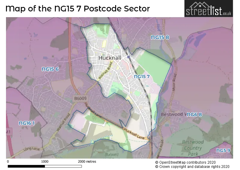
The NG15 7 Postcode shares a border with NG15 8 (Hucknall, Linby, Papplewick), NG6 8 (NOTTINGHAM, Bestwood Village, Bulwell) and NG15 6 (Hucknall).
The sector is within the post town of NOTTINGHAM.
NG15 7 is a postcode sector within the NG15 postcode district which is within the NG Nottingham postcode area.
The Royal Mail delivery office for the NG15 7 postal sector is the Hucknall Delivery Office.
The area of the NG15 7 postcode sector is 1.92 square miles which is 4.98 square kilometres or 1,230.59 square acres.
Waterways within the NG15 7 postcode sector include the River Leen.

Map of the NG15 7 Postcode Sector
Explore the NG15 7 postcode sector by using our free interactive map.
| N | G | 1 | 5 | - | 7 | X | X |
| N | G | 1 | 5 | Space | 7 | Letter | Letter |
Official List of Streets
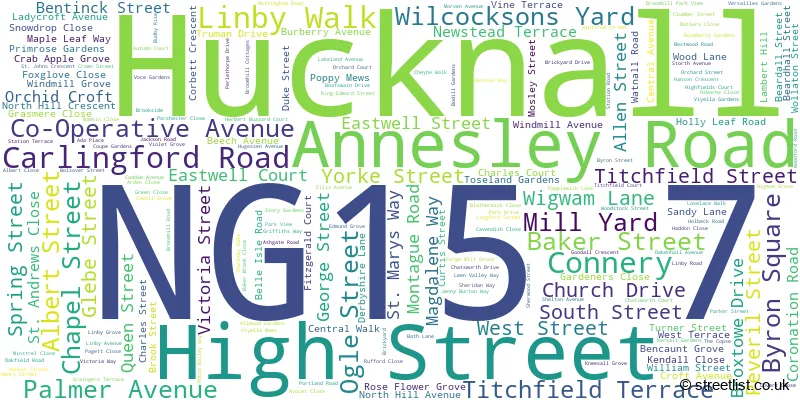
Hucknall (176 Streets)
Unofficial Streets or Alternative Spellings
Hucknall
AITCHISON AVENUE BARBARA SQUARE BRICKYARD CENTRAL WALK CO-OPERATIVE AVENUE CONISTON ROAD GARDEN ROAD GRAINGERS TERRACE HERBERT BUZZARD COURT KENBROOK ROAD KESTREL GROVE LAMBERT HILL LOVESEY AVENUE MILL YARD OLYMPIA WAY WASHDYKE LANE WENLOCK DRIVE BELLE-ISLE ROAD BOATSWAIN WAY BUS LINK DOREY WAY DUKES COURT FARLEYS LANE GILBERT STREET EAST GILBERT STREET WEST GRIFFON DRIVE HALLCROFT COURT HANDOVER COURT MANDEVILLE CLOSE MONTAGUE STREET RED LION YARD ST ANDREWS CLOSE ST MARYS VIEW STEDFAST COURT THE CONNERY TORKARD WAY WHYBURN COURT WHYBURN STREET WIGWAM COURT WOOLLATON STREETNOTTINGHAM
HUCKNALL LANEWeather Forecast for NG15 7
Press Button to Show Forecast for Hucknall
| Time Period | Icon | Description | Temperature | Rain Probability | Wind |
|---|---|---|---|---|---|
| 00:00 to 03:00 | Overcast | 9.0°C (feels like 6.0°C) | 14.00% | WNW 11 mph | |
| 03:00 to 06:00 | Cloudy | 9.0°C (feels like 6.0°C) | 40.00% | WNW 11 mph | |
| 06:00 to 09:00 | Light rain shower (day) | 8.0°C (feels like 5.0°C) | 36.00% | WNW 11 mph | |
| 09:00 to 12:00 | Cloudy | 10.0°C (feels like 7.0°C) | 8.00% | NW 13 mph | |
| 12:00 to 15:00 | Cloudy | 10.0°C (feels like 8.0°C) | 30.00% | N 11 mph | |
| 15:00 to 18:00 | Cloudy | 10.0°C (feels like 8.0°C) | 18.00% | N 11 mph | |
| 18:00 to 21:00 | Cloudy | 9.0°C (feels like 6.0°C) | 6.00% | NNE 9 mph | |
| 21:00 to 00:00 | Partly cloudy (night) | 6.0°C (feels like 4.0°C) | 1.00% | NNE 7 mph |
Press Button to Show Forecast for Hucknall
| Time Period | Icon | Description | Temperature | Rain Probability | Wind |
|---|---|---|---|---|---|
| 00:00 to 03:00 | Partly cloudy (night) | 5.0°C (feels like 2.0°C) | 1.00% | NNW 7 mph | |
| 03:00 to 06:00 | Cloudy | 4.0°C (feels like 1.0°C) | 4.00% | NNW 7 mph | |
| 06:00 to 09:00 | Cloudy | 4.0°C (feels like 1.0°C) | 4.00% | NNW 7 mph | |
| 09:00 to 12:00 | Cloudy | 7.0°C (feels like 4.0°C) | 5.00% | N 11 mph | |
| 12:00 to 15:00 | Overcast | 9.0°C (feels like 7.0°C) | 8.00% | N 9 mph | |
| 15:00 to 18:00 | Cloudy | 10.0°C (feels like 8.0°C) | 5.00% | N 9 mph | |
| 18:00 to 21:00 | Cloudy | 9.0°C (feels like 8.0°C) | 6.00% | NNE 7 mph | |
| 21:00 to 00:00 | Partly cloudy (night) | 7.0°C (feels like 6.0°C) | 2.00% | ENE 4 mph |
Press Button to Show Forecast for Hucknall
| Time Period | Icon | Description | Temperature | Rain Probability | Wind |
|---|---|---|---|---|---|
| 00:00 to 03:00 | Partly cloudy (night) | 6.0°C (feels like 5.0°C) | 1.00% | NE 4 mph | |
| 03:00 to 06:00 | Cloudy | 5.0°C (feels like 4.0°C) | 19.00% | NW 4 mph | |
| 06:00 to 09:00 | Overcast | 6.0°C (feels like 4.0°C) | 12.00% | N 4 mph | |
| 09:00 to 12:00 | Cloudy | 7.0°C (feels like 6.0°C) | 16.00% | NNE 7 mph | |
| 12:00 to 15:00 | Overcast | 9.0°C (feels like 7.0°C) | 12.00% | NNE 7 mph | |
| 15:00 to 18:00 | Overcast | 10.0°C (feels like 8.0°C) | 9.00% | NNE 9 mph | |
| 18:00 to 21:00 | Cloudy | 9.0°C (feels like 7.0°C) | 7.00% | NE 9 mph | |
| 21:00 to 00:00 | Partly cloudy (night) | 7.0°C (feels like 5.0°C) | 4.00% | NE 7 mph |
Press Button to Show Forecast for Hucknall
| Time Period | Icon | Description | Temperature | Rain Probability | Wind |
|---|---|---|---|---|---|
| 00:00 to 03:00 | Cloudy | 6.0°C (feels like 3.0°C) | 6.00% | NE 7 mph | |
| 03:00 to 06:00 | Partly cloudy (night) | 5.0°C (feels like 3.0°C) | 3.00% | NNE 7 mph | |
| 06:00 to 09:00 | Cloudy | 5.0°C (feels like 3.0°C) | 6.00% | NNE 7 mph | |
| 09:00 to 12:00 | Overcast | 8.0°C (feels like 6.0°C) | 10.00% | NNE 9 mph | |
| 12:00 to 15:00 | Cloudy | 9.0°C (feels like 7.0°C) | 17.00% | NE 9 mph | |
| 15:00 to 18:00 | Overcast | 10.0°C (feels like 7.0°C) | 17.00% | NE 9 mph | |
| 18:00 to 21:00 | Cloudy | 9.0°C (feels like 7.0°C) | 8.00% | NE 9 mph | |
| 21:00 to 00:00 | Partly cloudy (night) | 7.0°C (feels like 5.0°C) | 4.00% | ENE 7 mph |
Schools and Places of Education Within the NG15 7 Postcode Sector
Hucknall National Church of England Primary School
Academy converter
Montague Road, Nottingham, Nottinghamshire, NG15 7DU
Head: Miss Sarah Barratt
Ofsted Rating: Good
Inspection: 2023-06-28 (296 days ago)
Website: Visit Hucknall National Church of England Primary School Website
Phone: 01159632678
Number of Pupils: 418
The National CofE Academy
Academy converter
Annesley Road, Nottingham, Nottinghamshire, NG15 7DB
Head: Mr Martin Brailsford
Ofsted Rating: Good
Inspection: 2023-04-19 (366 days ago)
Website: Visit The National CofE Academy Website
Phone: 01159635667
Number of Pupils: 1214
House Prices in the NG15 7 Postcode Sector
| Type of Property | 2018 Average | 2018 Sales | 2017 Average | 2017 Sales | 2016 Average | 2016 Sales | 2015 Average | 2015 Sales |
|---|---|---|---|---|---|---|---|---|
| Detached | £223,823 | 36 | £231,271 | 64 | £226,758 | 87 | £230,562 | 58 |
| Semi-Detached | £144,976 | 61 | £140,989 | 101 | £131,092 | 81 | £125,138 | 66 |
| Terraced | £119,516 | 123 | £114,654 | 147 | £104,606 | 128 | £102,897 | 133 |
| Flats | £103,821 | 14 | £132,809 | 37 | £131,329 | 63 | £78,063 | 12 |
Important Postcodes NG15 7 in the Postcode Sector
NG15 7AA is the postcode for Royal Mail, Hucknall Delivery Office, 59 High Street
NG15 7BS is the postcode for Hucknall Library, 1 South Street, and Nottinghamshire County Council, Hucknall Library, South Street
NG15 7DB is the postcode for SCIENCE BLOCK, The National Church of England Academy, 231 Annesley Road, The National Academy, 231 Annesley Road, SIXTH FORM CENTRE, The National Church of England Academy, 231 Annesley Road, SCIENCE BLOCK, The National Academy, 231 Annesley Road, GREEN BUILDING, The National Academy, 231 Annesley Road, and The National Church of England Academy, 231 Annesley Road
NG15 7DU is the postcode for Hucknall National Primary School, Montague Road, COVERED PLAY AREA, Hucknall National C of E Primary School, Montague Road, and Hucknall National C of E Primary School, Montague Road
NG15 7JE is the postcode for Hucknall Health Centre, 54 Curtis Street, and Hucknall Health Centre, 54 Curtis Street, Hucknall
NG15 7JP is the postcode for OM SURGERY, 112 WATNALL ROAD
NG15 7JU is the postcode for Beardall Street Primary School, Beardall Street
NG15 7LA is the postcode for Ashfield District Council, Watnall Road
NG15 7LG is the postcode for Hucknall Police Station, Watnall Road
NG15 7LS is the postcode for Titchfield Cricket Pavilion, Park Drive
NG15 7NH is the postcode for Watnall Road Community Centre, Watnall Road
NG15 7SN is the postcode for The Hucknall Sixth Form Centre, Portland Road, New College Nottingham, Portland Road, and The Hucknall Sixth Form Centre, Portland Road, Hucknall
NG15 7TX is the postcode for Hucknall Leisure Centre, Linby Road, and Hucknall Leisure Centre, Linby Road, Hucknall
| The NG15 7 Sector is within these Local Authorities |
|
|---|---|
| The NG15 7 Sector is within these Counties |
|
| The NG15 7 Sector is within these Water Company Areas |
|