The NG16 6 postcode sector stands on the Derbyshire and Nottinghamshire border.
Did you know? According to the 2021 Census, the NG16 6 postcode sector is home to a bustling 11,308 residents!
Given that each sector allows for 400 unique postcode combinations. Letters C, I, K, M, O and V are not allowed in the last two letters of a postcode. With 245 postcodes already in use, this leaves 155 units available.
The largest settlements in the NG16 6 postal code are Selston and Pinxton.
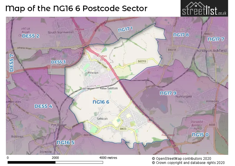
The NG16 6 Postcode shares a border with NG17 1 (SUTTON-IN-ASHFIELD), NG17 8 (Kirkby-in-Ashfield), NG17 9 (Kirkby-in-Ashfield), DE55 2 (South Normanton), DE55 4 (Somercotes, Riddings, Pye Bridge), NG16 5 (Brinsley, Underwood, Jacksdale) and DE55 3 (South Normanton).
The sector is within the post town of NOTTINGHAM.
NG16 6 is a postcode sector within the NG16 postcode district which is within the NG Nottingham postcode area.
The Royal Mail delivery office for the NG16 6 postal sector is the Eastwood Delivery Office and Pinxton Scale Payment Delivery Office.
The area of the NG16 6 postcode sector is 5.11 square miles which is 13.25 square kilometres or 3,273.58 square acres.
The NG16 6 postcode sector is crossed by the M1 motorway.
The NG16 6 postcode sector is crossed by the A38 Major A road.
Waterways within the NG16 6 postcode sector include the Erewash.

Map of the NG16 6 Postcode Sector
Explore the NG16 6 postcode sector by using our free interactive map.
| N | G | 1 | 6 | - | 6 | X | X |
| N | G | 1 | 6 | Space | 6 | Letter | Letter |
Official List of Streets
Pinxton (61 Streets)
Selston (99 Streets)
Unofficial Streets or Alternative Spellings
Kirkby-in-Ashfield
DOLES LANE PARK LANE PINXTON LANE SALMON LANESelston
VICTORIA TERRACE BESTWOOD ROAD COMMON SIDE EREWASH ROAD GREENSIDE GREENSQUARE ROAD LONGWOOD ROAD MAWKIN LANE PINXTON GREEN PINXTON INTERCHANGE SALSTUNE MEWS SCHOOL DRIVE SOVERIGN GARDENS SUFF LANESouth Normanton
MANSFIELD ROAD STORTH LANEPye Bridge
ALFRETON ROADWeather Forecast for NG16 6
Press Button to Show Forecast for Kirkby In Ashfield
| Time Period | Icon | Description | Temperature | Rain Probability | Wind |
|---|---|---|---|---|---|
| 12:00 to 15:00 | Cloudy | 6.0°C (feels like 3.0°C) | 50.00% | NNE 9 mph | |
| 15:00 to 18:00 | Cloudy | 8.0°C (feels like 6.0°C) | 7.00% | N 7 mph | |
| 18:00 to 21:00 | Cloudy | 7.0°C (feels like 5.0°C) | 6.00% | ENE 7 mph | |
| 21:00 to 00:00 | Cloudy | 4.0°C (feels like 2.0°C) | 5.00% | ENE 7 mph |
Press Button to Show Forecast for Kirkby In Ashfield
| Time Period | Icon | Description | Temperature | Rain Probability | Wind |
|---|---|---|---|---|---|
| 00:00 to 03:00 | Partly cloudy (night) | 2.0°C (feels like 0.0°C) | 1.00% | NE 4 mph | |
| 03:00 to 06:00 | Partly cloudy (night) | 1.0°C (feels like -1.0°C) | 2.00% | N 4 mph | |
| 06:00 to 09:00 | Sunny day | 2.0°C (feels like -1.0°C) | 1.00% | N 4 mph | |
| 09:00 to 12:00 | Cloudy | 6.0°C (feels like 4.0°C) | 5.00% | NE 7 mph | |
| 12:00 to 15:00 | Overcast | 8.0°C (feels like 7.0°C) | 9.00% | ENE 4 mph | |
| 15:00 to 18:00 | Cloudy | 9.0°C (feels like 8.0°C) | 7.00% | ENE 4 mph | |
| 18:00 to 21:00 | Cloudy | 7.0°C (feels like 5.0°C) | 8.00% | ENE 7 mph | |
| 21:00 to 00:00 | Partly cloudy (night) | 4.0°C (feels like 2.0°C) | 7.00% | ENE 4 mph |
Press Button to Show Forecast for Kirkby In Ashfield
| Time Period | Icon | Description | Temperature | Rain Probability | Wind |
|---|---|---|---|---|---|
| 00:00 to 03:00 | Cloudy | 3.0°C (feels like 1.0°C) | 9.00% | NNE 4 mph | |
| 03:00 to 06:00 | Cloudy | 2.0°C (feels like 0.0°C) | 11.00% | NNE 4 mph | |
| 06:00 to 09:00 | Cloudy | 3.0°C (feels like 1.0°C) | 10.00% | NNE 7 mph | |
| 09:00 to 12:00 | Cloudy | 7.0°C (feels like 4.0°C) | 12.00% | ENE 9 mph | |
| 12:00 to 15:00 | Overcast | 9.0°C (feels like 6.0°C) | 20.00% | E 9 mph | |
| 15:00 to 18:00 | Cloudy | 9.0°C (feels like 7.0°C) | 20.00% | ENE 11 mph | |
| 18:00 to 21:00 | Cloudy | 8.0°C (feels like 6.0°C) | 19.00% | ENE 11 mph | |
| 21:00 to 00:00 | Cloudy | 6.0°C (feels like 3.0°C) | 17.00% | NE 11 mph |
Press Button to Show Forecast for Kirkby In Ashfield
| Time Period | Icon | Description | Temperature | Rain Probability | Wind |
|---|---|---|---|---|---|
| 00:00 to 03:00 | Cloudy | 5.0°C (feels like 2.0°C) | 20.00% | NE 11 mph | |
| 03:00 to 06:00 | Light rain | 6.0°C (feels like 2.0°C) | 50.00% | NNE 13 mph | |
| 06:00 to 09:00 | Heavy rain | 6.0°C (feels like 2.0°C) | 75.00% | NNE 13 mph | |
| 09:00 to 12:00 | Heavy rain | 7.0°C (feels like 4.0°C) | 79.00% | NNE 13 mph | |
| 12:00 to 15:00 | Heavy rain | 8.0°C (feels like 5.0°C) | 77.00% | NE 13 mph | |
| 15:00 to 18:00 | Light rain | 9.0°C (feels like 6.0°C) | 50.00% | N 11 mph | |
| 18:00 to 21:00 | Light rain shower (day) | 9.0°C (feels like 6.0°C) | 39.00% | N 9 mph | |
| 21:00 to 00:00 | Partly cloudy (night) | 6.0°C (feels like 4.0°C) | 9.00% | SE 7 mph |
Schools and Places of Education Within the NG16 6 Postcode Sector
Holly Hill Primary and Nursery School
Community school
School Road, Off Portland Road, Nottingham, Nottinghamshire, NG16 6AW
Head: Mrs Leanne Steed
Ofsted Rating: Good
Inspection: 2023-11-22 (155 days ago)
Website: Visit Holly Hill Primary and Nursery School Website
Phone: 01773783909
Number of Pupils: 329
John King Infant Academy
Academy converter
Church Street West, Pinxton, Derbyshire, NG16 6NB
Head: Mrs Anne Ingle
Ofsted Rating: Good
Inspection: 2022-06-08 (687 days ago)
Website: Visit John King Infant Academy Website
Phone: 01773303420
Number of Pupils: 104
Kirkstead Junior Academy
Academy sponsor led
Kirkstead Road, Pinxton, , NG16 6NA
Head: Mrs Anne Ingle
Ofsted Rating: Good
Inspection: 2022-06-29 (666 days ago)
Website: Visit Kirkstead Junior Academy Website
Phone: 01773303420
Number of Pupils: 218
Longwood Infant Academy
Academy converter
Wharf Road, Nottingham, , NG16 6PA
Head: Mrs Anne Ingle
Ofsted Rating: Outstanding
Inspection: 2023-11-29 (148 days ago)
Website: Visit Longwood Infant Academy Website
Phone: 01773303420
Number of Pupils: 50
Pinxton Nursery School
Local authority nursery school
Kirkstead Road, Nottingham, Nottinghamshire, NG16 6NA
Head: Mrs Jayne Allton
Ofsted Rating: Good
Inspection: 2023-05-10 (351 days ago)
Website: Visit Pinxton Nursery School Website
Phone: 01773863105
Number of Pupils: 67
Selston High School
Academy converter
Chapel Road, Nottingham, Nottinghamshire, NG16 6BW
Head: Mr David Broomhead
Ofsted Rating: Good
Inspection: 2019-04-03 (1849 days ago)
Website: Visit Selston High School Website
Phone: 01773810321
Number of Pupils: 863
House Prices in the NG16 6 Postcode Sector
| Type of Property | 2018 Average | 2018 Sales | 2017 Average | 2017 Sales | 2016 Average | 2016 Sales | 2015 Average | 2015 Sales |
|---|---|---|---|---|---|---|---|---|
| Detached | £208,452 | 80 | £190,838 | 78 | £175,782 | 88 | £167,901 | 74 |
| Semi-Detached | £126,877 | 66 | £120,775 | 63 | £114,549 | 70 | £114,922 | 69 |
| Terraced | £90,516 | 45 | £87,771 | 39 | £84,052 | 58 | £78,274 | 39 |
| Flats | £58,000 | 1 | £44,000 | 1 | £45,000 | 1 | £64,625 | 2 |
Important Postcodes NG16 6 in the Postcode Sector
NG16 6AW is the postcode for Hollyhill Nursery School, School Road, Hollyhill Primary School, School Road, Selston, Hollyhill Primary School, School Road, and Holly Hill Primary School, Selston - CLASP Building, Portland Road
NG16 6BT is the postcode for Selston Community Unit, 139 Nottingham Road, and Selston Community Unit, 137 Nottingham Road
NG16 6BW is the postcode for TEACHING BLOCK, Selston Arts & Community College, Chapel Road, DINING & KITCHEN, Selston Arts & Community College, Chapel Road, BUILDING 4 ENGINEERING BLOCK, Selston Arts & Community College, Chapel Road, Nottinghamshire County Council, Selston Library, Chapel Road, Selston High School - Teaching Block, Chapel Road, Selston, Selston Arts & Community College, Chapel Road, SELSTON HIGH SCHOOL, CHAPEL ROAD, and Selston Leisure Centre, Chapel Road
NG16 6DH is the postcode for Selston C of E Infant & Nursery School, Nottingham Road
NG16 6NA is the postcode for Kirkstead Junior School, Kirkstead Road, Pinxton Nursery School, Kirkstead Road, and Pinxton Youth Centre, Kirkstead Road
NG16 6NB is the postcode for John King Infant School, Church Street West
NG16 6PA is the postcode for Longwood Community Infant School, Wharf Road
| The NG16 6 Sector is within these Local Authorities |
|
|---|---|
| The NG16 6 Sector is within these Counties |
|
| The NG16 6 Sector is within these Water Company Areas |
|