The NG17 postcode district is a postal district located in the NG Nottingham postcode area with a population of 75,325 residents according to the 2021 England and Wales Census.
The area of the NG17 postcode district is 21.83 square miles which is 56.53 square kilometres or 13,968.65 acres.
Currently, the NG17 district has about 1607 postcode units spread across 9 geographic postcode sectors.
Given that each sector allows for 400 unique postcode combinations, the district has a capacity of 3,600 postcodes. With 1607 postcodes already in use, this leaves 1993 units available.
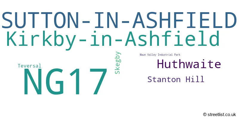
The largest settlement in the NG17 postal code is SUTTON-IN-ASHFIELD followed by Kirkby-in-Ashfield, and Huthwaite.
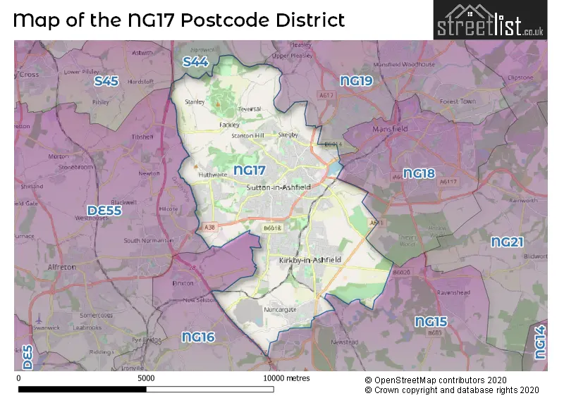
The NG17 Postcode shares a border with DE55 (South Normanton, ALFRETON, Somercotes), NG16 (Eastwood, Selston, Langley Mill), S44 (Bolsover, Calow, Duckmanton), NG15 (Hucknall, Ravenshead, Annesley), NG18 (MANSFIELD) and NG19 (Mansfield Woodhouse, MANSFIELD, Forest Town).
The primary settlement in the NG17 postcode district is Sutton-in-Ashfield, which is located in Nottinghamshire, England. The most significant post town in this district is Sutton-in-Ashfield as well. The other significant settlements in this district include Huthwaite, Skegby, Stanton Hill, Teversal, Maun Valley Industrial Park, and Kirkby-in-Ashfield, which is located in Nottinghamshire, England.
For the district NG17, we have data on 10 postcode sectors. Here's a breakdown: The sector NG17 0 is non-geographic. It's often designated for PO Boxes, large organisations, or special services. The sector NG17 1, covers Sutton-In-Ashfield in Nottinghamshire. The sector NG17 2, covers Sutton-In-Ashfield and Huthwaite in Nottinghamshire. The sector NG17 3, covers Sutton-In-Ashfield and Stanton Hill and Skegby in Nottinghamshire. The sector NG17 4, covers Sutton-In-Ashfield in Nottinghamshire. The sector NG17 5, covers Sutton-In-Ashfield in Nottinghamshire. The sector NG17 6, covers Huthwaite in Nottinghamshire. The sector NG17 7, covers Kirkby-In-Ashfield in Nottinghamshire. The sector NG17 8, covers Kirkby-In-Ashfield in Nottinghamshire. The sector NG17 9, covers Kirkby-In-Ashfield in Nottinghamshire.

Map of the NG17 Postcode District
Explore the NG17 postcode district by using our free interactive map.
When it comes to local government, postal geography often disregards political borders. However, for a breakdown in the NG17 District: the district mostly encompasses the Ashfield District (1617 postcodes), and finally, the Mansfield District area (4 postcodes).
Recent House Sales in NG17
| Date | Price | Address |
|---|---|---|
| 23/10/2023 | £65,000 | Caunts Crescent, Sutton-in-ashfield, NG17 2FH |
| 20/10/2023 | £90,950 | New Street, Huthwaite, Sutton-in-ashfield, NG17 2LR |
| 17/10/2023 | £86,000 | Mary Street, Kirkby In Ashfield, Nottingham, NG17 7JT |
| 13/10/2023 | £130,000 | Chesterfield Road, Huthwaite, Sutton-in-ashfield, NG17 2PZ |
| 11/10/2023 | £148,000 | Martyn Avenue, Sutton-in-ashfield, NG17 5DH |
| 06/10/2023 | £215,000 | Harlow Close, Sutton-in-ashfield, NG17 3AX |
| 04/10/2023 | £61,500 | Sherwood Road, Sutton-in-ashfield, NG17 1GU |
| 29/09/2023 | £147,500 | Park Street, Kirkby In Ashfield, Nottingham, NG17 8DY |
| 29/09/2023 | £165,000 | Brown Crescent, Sutton-in-ashfield, NG17 4GY |
| 29/09/2023 | £200,000 | Lime Avenue, Huthwaite, Sutton-in-ashfield, NG17 2NR |
Weather Forecast for NG17
Press Button to Show Forecast for Sutton In Ashfield
| Time Period | Icon | Description | Temperature | Rain Probability | Wind |
|---|---|---|---|---|---|
| 15:00 to 18:00 | Cloudy | 8.0°C (feels like 6.0°C) | 12.00% | NNW 4 mph | |
| 18:00 to 21:00 | Cloudy | 7.0°C (feels like 5.0°C) | 6.00% | NE 7 mph | |
| 21:00 to 00:00 | Cloudy | 4.0°C (feels like 2.0°C) | 4.00% | ENE 7 mph |
Press Button to Show Forecast for Sutton In Ashfield
| Time Period | Icon | Description | Temperature | Rain Probability | Wind |
|---|---|---|---|---|---|
| 00:00 to 03:00 | Partly cloudy (night) | 2.0°C (feels like 1.0°C) | 1.00% | NE 4 mph | |
| 03:00 to 06:00 | Partly cloudy (night) | 1.0°C (feels like -1.0°C) | 1.00% | N 4 mph | |
| 06:00 to 09:00 | Sunny day | 2.0°C (feels like -1.0°C) | 1.00% | N 4 mph | |
| 09:00 to 12:00 | Partly cloudy (day) | 6.0°C (feels like 4.0°C) | 2.00% | NE 7 mph | |
| 12:00 to 15:00 | Cloudy | 8.0°C (feels like 7.0°C) | 9.00% | E 4 mph | |
| 15:00 to 18:00 | Cloudy | 9.0°C (feels like 8.0°C) | 7.00% | ENE 4 mph | |
| 18:00 to 21:00 | Cloudy | 7.0°C (feels like 5.0°C) | 8.00% | ENE 7 mph | |
| 21:00 to 00:00 | Partly cloudy (night) | 4.0°C (feels like 3.0°C) | 10.00% | E 4 mph |
Press Button to Show Forecast for Sutton In Ashfield
| Time Period | Icon | Description | Temperature | Rain Probability | Wind |
|---|---|---|---|---|---|
| 00:00 to 03:00 | Cloudy | 4.0°C (feels like 2.0°C) | 9.00% | NNE 4 mph | |
| 03:00 to 06:00 | Cloudy | 3.0°C (feels like 1.0°C) | 11.00% | NNE 4 mph | |
| 06:00 to 09:00 | Cloudy | 3.0°C (feels like 1.0°C) | 10.00% | NNE 7 mph | |
| 09:00 to 12:00 | Cloudy | 7.0°C (feels like 4.0°C) | 12.00% | ENE 9 mph | |
| 12:00 to 15:00 | Cloudy | 9.0°C (feels like 6.0°C) | 17.00% | E 9 mph | |
| 15:00 to 18:00 | Cloudy | 9.0°C (feels like 7.0°C) | 19.00% | ENE 9 mph | |
| 18:00 to 21:00 | Cloudy | 8.0°C (feels like 6.0°C) | 19.00% | ENE 11 mph | |
| 21:00 to 00:00 | Cloudy | 6.0°C (feels like 3.0°C) | 17.00% | NE 9 mph |
Press Button to Show Forecast for Sutton In Ashfield
| Time Period | Icon | Description | Temperature | Rain Probability | Wind |
|---|---|---|---|---|---|
| 00:00 to 03:00 | Overcast | 6.0°C (feels like 2.0°C) | 24.00% | NE 11 mph | |
| 03:00 to 06:00 | Light rain | 6.0°C (feels like 2.0°C) | 51.00% | NNE 11 mph | |
| 06:00 to 09:00 | Heavy rain | 6.0°C (feels like 3.0°C) | 76.00% | NNE 13 mph | |
| 09:00 to 12:00 | Heavy rain | 7.0°C (feels like 4.0°C) | 79.00% | NNE 11 mph | |
| 12:00 to 15:00 | Heavy rain | 9.0°C (feels like 6.0°C) | 77.00% | N 11 mph | |
| 15:00 to 18:00 | Light rain | 9.0°C (feels like 6.0°C) | 51.00% | N 11 mph | |
| 18:00 to 21:00 | Light rain shower (day) | 9.0°C (feels like 6.0°C) | 39.00% | N 9 mph | |
| 21:00 to 00:00 | Partly cloudy (night) | 7.0°C (feels like 5.0°C) | 9.00% | SE 7 mph |
Where is the NG17 Postcode District?
The data suggests that the postcode district NG17 is located in Sutton-in-Ashfield. Sutton-in-Ashfield is located near several towns, including Mansfield (3.28 miles to the north east), Alfreton (5.79 miles to the west), Ripley (7.88 miles to the south west), Chesterfield (9.58 miles to the north west), Nottingham (9.91 miles to the south east), and Ilkeston (10.41 miles to the south). Additionally, the distance from Sutton-in-Ashfield to the centre of London is approximately 121.44 miles.
The district covers the post towns of NOTTINGHAM, SUTTON-IN-ASHFIELD.
The sector has postcodes within the nation of England.
The NG17 Postcode District is in the North Nottinghamshire region of Derbyshire and Nottinghamshire within the East Midlands (England).
Postcode Sectors within the NG17 District
| Postcode Sector | Delivery Office |
|---|---|
| NG17 1 | Sutton-in-ashfield Delivery Office |
| NG17 2 | Sutton-in-ashfield Delivery Office |
| NG17 3 | Sutton-in-ashfield Delivery Office |
| NG17 4 | Sutton-in-ashfield Delivery Office |
| NG17 5 | Sutton-in-ashfield Delivery Office |
| NG17 6 | Sutton-in-ashfield Delivery Office |
| NG17 7 | Kirkby-in-ashfield Delivery Office |
| NG17 8 | Kirkby-in-ashfield Delivery Office |
| NG17 9 | Kirkby-in-ashfield Delivery Office |
| N | G | 1 | 7 | - | X | X | X |
| N | G | 1 | 7 | Space | Numeric | Letter | Letter |
Tourist Attractions within the Postcode Area
We found 1 visitor attractions within the NG17 postcode area
| Teversal Trails Visitors Centre |
|---|
| Visitor Centres |
| Heritage / Visitor Centre |
| View Teversal Trails Visitors Centre on Google Maps |
Current Monthly Rental Prices
| # Bedrooms | Min Price | Max Price | Avg Price |
|---|---|---|---|
| 1 | £425 | £695 | £551 |
| 2 | £495 | £795 | £673 |
| 3 | £600 | £1,130 | £837 |
| 4 | £1,300 | £1,300 | £1,300 |
| 5 | £1,700 | £1,700 | £1,700 |
Current House Prices
| # Bedrooms | Min Price | Max Price | Avg Price |
|---|---|---|---|
| £100 | £450,000 | £221,258 | |
| 1 | £89,950 | £110,000 | £96,650 |
| 2 | £49,995 | £300,000 | £156,274 |
| 3 | £65,000 | £450,000 | £208,610 |
| 4 | £100,000 | £770,000 | £349,739 |
| 5 | £150,000 | £780,000 | £429,857 |
| 6 | £250,000 | £415,000 | £355,000 |
| 7 | £475,000 | £475,000 | £475,000 |
Estate Agents who Operate in the NG17 District
| Logo | Name | Brand Name | Address | Contact Number | Total Properties |
|---|---|---|---|---|---|
 | Mansfield | BuckleyBrown | 55-57 Leeming Street, Mansfield, Notts, NG18 1ND | 01623 705218 | 43 |
 | Sutton in Ashfield | Bairstow Eves | 47 Forest Street, Sutton-in-Ashfield, Nottinghamshire, NG17 1DA | 01623 708591 | 40 |
 | covering Nottingham | Purplebricks | Suite 7 First Floor Cranmore Drive Shirley Solihull B90 4RZ | 020 3908 1066 | 33 |
 | Kirkby-In-Ashfield | Your Move | 82 Station Street Kirkby-In-Ashfield NG17 7AP | 01623 701197 | 32 |
 | Kirkby-In-Ashfield | English Rose Estate Agents Ltd | 1 Kingsway Court Kingsway Kirkby-In-Ashfield NG17 7BB | 01623 705619 | 23 |
| Type of Property | 2018 Average | 2018 Sales | 2017 Average | 2017 Sales | 2016 Average | 2016 Sales | 2015 Average | 2015 Sales |
|---|---|---|---|---|---|---|---|---|
| Detached | £202,021 | 382 | £190,559 | 427 | £182,262 | 429 | £171,926 | 376 |
| Semi-Detached | £122,890 | 461 | £115,306 | 466 | £113,910 | 468 | £102,994 | 421 |
| Terraced | £91,500 | 341 | £89,571 | 370 | £91,122 | 354 | £84,451 | 346 |
| Flats | £61,571 | 17 | £65,127 | 27 | £69,555 | 31 | £76,104 | 9 |