The NG17 4 postcode sector is within the county of Nottinghamshire.
Did you know? According to the 2021 Census, the NG17 4 postcode sector is home to a bustling 10,470 residents!
Given that each sector allows for 400 unique postcode combinations. Letters C, I, K, M, O and V are not allowed in the last two letters of a postcode. With 195 postcodes already in use, this leaves 205 units available.
The NG17 4 postal code covers the settlement of SUTTON-IN-ASHFIELD.
The NG17 4 Postcode shares a border with NG17 1 (SUTTON-IN-ASHFIELD), NG17 5 (SUTTON-IN-ASHFIELD, Maun Valley Industrial Park), NG18 5 (MANSFIELD), NG19 6 (MANSFIELD), NG17 2 (SUTTON-IN-ASHFIELD, Huthwaite) and NG17 3 (SUTTON-IN-ASHFIELD, Stanton Hill, Skegby).
The sector is within the post town of SUTTON-IN-ASHFIELD.
NG17 4 is a postcode sector within the NG17 postcode district which is within the NG Nottingham postcode area.
The Royal Mail delivery office for the NG17 4 postal sector is the Sutton-in-ashfield Delivery Office.
The area of the NG17 4 postcode sector is 1.20 square miles which is 3.12 square kilometres or 770.02 square acres.

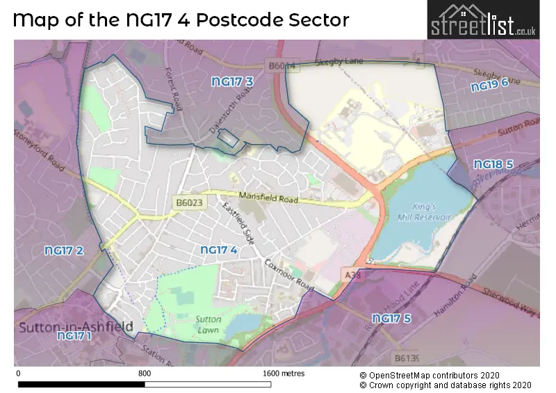
Map of the NG17 4 Postcode Sector
Explore the NG17 4 postcode sector by using our free interactive map.
| N | G | 1 | 7 | - | 4 | X | X |
| N | G | 1 | 7 | Space | 4 | Letter | Letter |
Official List of Streets
SUTTON-IN-ASHFIELD (128 Streets)
Unofficial Streets or Alternative Spellings
MANSFIELD
SUTTON ROADSUTTON-IN-ASHFIELD
DALESTORTH ROAD GRENDON WAY LAWN AVENUE NORTHERN VIEW SAVILLE ROAD SCARCLIFFE COURT WHITEHEAD LANE BRIDGE CLOSE FACTORY YARD FOX STREET LAWN LANE NORTHERN BRIDGE ROAD SAMUEL UNWIN COURT SHAW CROFT SHEEPWASH LANE SKEGBY TRAIL UNWIN LANE WILMORE WAYMANSFIELD,
SKEGBY LANEWeather Forecast for NG17 4
Press Button to Show Forecast for Sutton In Ashfield
| Time Period | Icon | Description | Temperature | Rain Probability | Wind |
|---|---|---|---|---|---|
| 15:00 to 18:00 | Cloudy | 8.0°C (feels like 6.0°C) | 12.00% | NNW 4 mph | |
| 18:00 to 21:00 | Cloudy | 7.0°C (feels like 5.0°C) | 6.00% | NE 7 mph | |
| 21:00 to 00:00 | Cloudy | 4.0°C (feels like 2.0°C) | 4.00% | ENE 7 mph |
Press Button to Show Forecast for Sutton In Ashfield
| Time Period | Icon | Description | Temperature | Rain Probability | Wind |
|---|---|---|---|---|---|
| 00:00 to 03:00 | Partly cloudy (night) | 2.0°C (feels like 1.0°C) | 1.00% | NE 4 mph | |
| 03:00 to 06:00 | Partly cloudy (night) | 1.0°C (feels like -1.0°C) | 1.00% | N 4 mph | |
| 06:00 to 09:00 | Sunny day | 2.0°C (feels like -1.0°C) | 1.00% | N 4 mph | |
| 09:00 to 12:00 | Partly cloudy (day) | 6.0°C (feels like 4.0°C) | 2.00% | NE 7 mph | |
| 12:00 to 15:00 | Cloudy | 8.0°C (feels like 7.0°C) | 9.00% | E 4 mph | |
| 15:00 to 18:00 | Cloudy | 9.0°C (feels like 8.0°C) | 7.00% | ENE 4 mph | |
| 18:00 to 21:00 | Cloudy | 7.0°C (feels like 5.0°C) | 8.00% | ENE 7 mph | |
| 21:00 to 00:00 | Partly cloudy (night) | 4.0°C (feels like 3.0°C) | 10.00% | E 4 mph |
Press Button to Show Forecast for Sutton In Ashfield
| Time Period | Icon | Description | Temperature | Rain Probability | Wind |
|---|---|---|---|---|---|
| 00:00 to 03:00 | Cloudy | 4.0°C (feels like 2.0°C) | 9.00% | NNE 4 mph | |
| 03:00 to 06:00 | Cloudy | 3.0°C (feels like 1.0°C) | 11.00% | NNE 4 mph | |
| 06:00 to 09:00 | Cloudy | 3.0°C (feels like 1.0°C) | 10.00% | NNE 7 mph | |
| 09:00 to 12:00 | Cloudy | 7.0°C (feels like 4.0°C) | 12.00% | ENE 9 mph | |
| 12:00 to 15:00 | Cloudy | 9.0°C (feels like 6.0°C) | 17.00% | E 9 mph | |
| 15:00 to 18:00 | Cloudy | 9.0°C (feels like 7.0°C) | 19.00% | ENE 9 mph | |
| 18:00 to 21:00 | Cloudy | 8.0°C (feels like 6.0°C) | 19.00% | ENE 11 mph | |
| 21:00 to 00:00 | Cloudy | 6.0°C (feels like 3.0°C) | 17.00% | NE 9 mph |
Press Button to Show Forecast for Sutton In Ashfield
| Time Period | Icon | Description | Temperature | Rain Probability | Wind |
|---|---|---|---|---|---|
| 00:00 to 03:00 | Overcast | 6.0°C (feels like 2.0°C) | 24.00% | NE 11 mph | |
| 03:00 to 06:00 | Light rain | 6.0°C (feels like 2.0°C) | 51.00% | NNE 11 mph | |
| 06:00 to 09:00 | Heavy rain | 6.0°C (feels like 3.0°C) | 76.00% | NNE 13 mph | |
| 09:00 to 12:00 | Heavy rain | 7.0°C (feels like 4.0°C) | 79.00% | NNE 11 mph | |
| 12:00 to 15:00 | Heavy rain | 9.0°C (feels like 6.0°C) | 77.00% | N 11 mph | |
| 15:00 to 18:00 | Light rain | 9.0°C (feels like 6.0°C) | 51.00% | N 11 mph | |
| 18:00 to 21:00 | Light rain shower (day) | 9.0°C (feels like 6.0°C) | 39.00% | N 9 mph | |
| 21:00 to 00:00 | Partly cloudy (night) | 7.0°C (feels like 5.0°C) | 9.00% | SE 7 mph |
Schools and Places of Education Within the NG17 4 Postcode Sector
Dalestorth Primary and Nursery School
Community school
Hill Crescent, Sutton-in-Ashfield, Nottinghamshire, NG17 4JA
Head: Mr Craig Robertson
Ofsted Rating: Good
Inspection: 2022-11-03 (539 days ago)
Website: Visit Dalestorth Primary and Nursery School Website
Phone: 01623459339
Number of Pupils: 359
Hillocks Primary Academy
Academy sponsor led
Unwin Road, Sutton-in-Ashfield, , NG17 4ND
Head: Mrs Lucy Spacey
Ofsted Rating: Requires improvement
Inspection: 2023-09-14 (224 days ago)
Website: Visit Hillocks Primary Academy Website
Phone: 01623408785
Number of Pupils: 314
Priestsic Primary and Nursery School
Community school
Park Street, Sutton-in-Ashfield, Nottinghamshire, NG17 4BB
Head: Mrs Sarah Stamp
Ofsted Rating: Good
Inspection: 2022-07-20 (645 days ago)
Website: Visit Priestsic Primary and Nursery School Website
Phone: 01623465705
Number of Pupils: 442
House Prices in the NG17 4 Postcode Sector
| Type of Property | 2018 Average | 2018 Sales | 2017 Average | 2017 Sales | 2016 Average | 2016 Sales | 2015 Average | 2015 Sales |
|---|---|---|---|---|---|---|---|---|
| Detached | £186,186 | 35 | £163,895 | 44 | £166,264 | 40 | £156,361 | 42 |
| Semi-Detached | £122,751 | 63 | £108,501 | 69 | £111,165 | 54 | £99,912 | 45 |
| Terraced | £82,957 | 79 | £78,870 | 79 | £80,147 | 79 | £73,988 | 69 |
| Flats | £55,000 | 3 | £85,000 | 1 | £71,954 | 12 | £57,500 | 1 |
Important Postcodes NG17 4 in the Postcode Sector
NG17 4BB is the postcode for PRIESTSIC PRIMARY SCHOOL AND NURSERY, PARK STREET, SUTTON IN ASHFIELD, BUILDING 3, Priestsic Primary School, Park Street, Priestsic Primary School, Park Street, and Priestsic Primary School And Nursery, Park Street
NG17 4FL is the postcode for BUILDING 2, Forest Glade Primary School, Mansfield Road, and Forest Glade Primary School, Mansfield Road
NG17 4HJ is the postcode for Nottinghamshire County Council Mental Health, Rokerfield Day Centre, 401 Mansfield Road, Nottinghamshire County Teaching PCT, John Eastwood Hospice, and John Eastwood Hospice, Mansfield Road
NG17 4JA is the postcode for Dalestorth Primary & Nursery School, Hill Crescent, and Dalestorth Primary And Nursery School, Hill Crescent
NG17 4JL is the postcode for TRUST OFFICES, Kings Mill Hospital, Mansfield Road, MAIN BLOCK, Kings Mill Hospital, Mansfield Road, BLOCK 24 - FS WORKSHOPS, Kings Mill Hospital, Mansfield Road, TRUST OFFICES - TB3, Kings Mill Hospital, Mansfield Road, CSSD AND PHARMACY, Kings Mill Hospital, Mansfield Road, and Millbrook MHU, Mansfield Road
NG17 4JT is the postcode for Sherwood Forest Hospitals NHS Foundation Trust, Kings Mill Hospital, and Nottinghamshire Healthcare NHS Trust, Millbrook Unit
NG17 4ND is the postcode for MAIN SCHOOL, Hillocks Primary School, Unwin Road, and SPORTS HALL, Hillocks Primary School, Unwin Road
NG17 4PA is the postcode for The Mill Adventure Base, Kingsmill Reservoir, Sherwood Way South
NG17 4PD is the postcode for Doctors Surgery, Harwood Close
| The NG17 4 Sector is within these Local Authorities |
|
|---|---|
| The NG17 4 Sector is within these Counties |
|
| The NG17 4 Sector is within these Water Company Areas |
|