The NG18 2 postcode sector is within the county of Nottinghamshire.
Did you know? According to the 2021 Census, the NG18 2 postcode sector is home to a bustling 8,654 residents!
Given that each sector allows for 400 unique postcode combinations. Letters C, I, K, M, O and V are not allowed in the last two letters of a postcode. With 191 postcodes already in use, this leaves 209 units available.
The NG18 2 postal code covers the settlement of MANSFIELD.
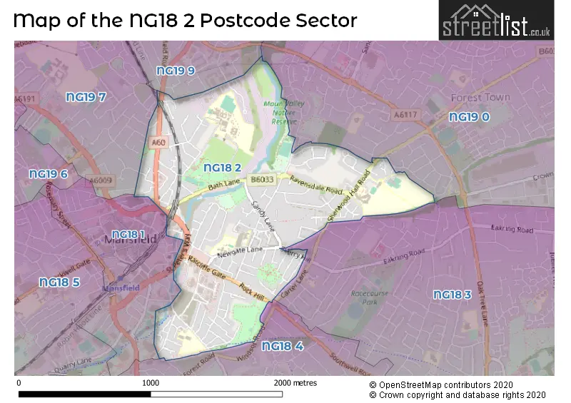
The NG18 2 Postcode shares a border with NG18 1 (MANSFIELD), NG18 3 (MANSFIELD), NG18 4 (MANSFIELD, Harlow Wood), NG19 9 (Mansfield Woodhouse), NG19 0 (Forest Town) and NG19 7 (MANSFIELD, Pleasley, Mansfield Woodhouse).
The sector is within the post town of MANSFIELD.
NG18 2 is a postcode sector within the NG18 postcode district which is within the NG Nottingham postcode area.
The Royal Mail delivery office for the NG18 2 postal sector is the Mansfield Delivery Office.
The area of the NG18 2 postcode sector is 0.95 square miles which is 2.46 square kilometres or 606.68 square acres.
Waterways within the NG18 2 postcode sector include the River Maun.

Map of the NG18 2 Postcode Sector
Explore the NG18 2 postcode sector by using our free interactive map.
| N | G | 1 | 8 | - | 2 | X | X |
| N | G | 1 | 8 | Space | 2 | Letter | Letter |
Official List of Streets
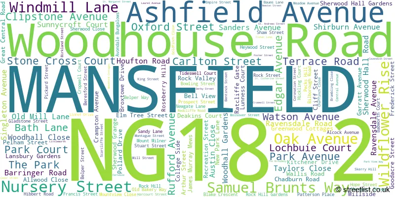
MANSFIELD (132 Streets)
Unofficial Streets or Alternative Spellings
MANSFIELD
BIRDING STREET BLACKTHORN DRIVE BRIDGE STREET CHESTERFIELD ROAD SOUTH CLIFTON PLACE CROW HILL DRIVE FOREST AVENUE HADDON ROAD LEEMING STREET THE WOODLANDS WEIGHBRIDGE ROAD WINDSOR ROADForest Town
CLIPSTONE ROAD WEST ELLESMERE ROAD STUART AVENUE FARMWAY HALLAMWAY HEYWARD STREET KINGSTON ROAD LINNETS DRIVE NURSERY COURT RAYMOND WAY ST PETERS WAY TIMBERLAND TRAIL WILD FLOWER RISEMansfield Woodhouse
LEEMING LANE SOUTHWeather Forecast for NG18 2
Press Button to Show Forecast for Mansfield
| Time Period | Icon | Description | Temperature | Rain Probability | Wind |
|---|---|---|---|---|---|
| 00:00 to 03:00 | Cloudy | 5.0°C (feels like 3.0°C) | 4.00% | SSW 4 mph | |
| 03:00 to 06:00 | Cloudy | 4.0°C (feels like 1.0°C) | 4.00% | WSW 7 mph | |
| 06:00 to 09:00 | Cloudy | 5.0°C (feels like 1.0°C) | 4.00% | WSW 9 mph | |
| 09:00 to 12:00 | Light rain shower (day) | 7.0°C (feels like 4.0°C) | 35.00% | NW 9 mph | |
| 12:00 to 15:00 | Overcast | 7.0°C (feels like 4.0°C) | 11.00% | NNE 9 mph | |
| 15:00 to 18:00 | Cloudy | 8.0°C (feels like 7.0°C) | 7.00% | NNW 7 mph | |
| 18:00 to 21:00 | Cloudy | 8.0°C (feels like 6.0°C) | 5.00% | NE 7 mph | |
| 21:00 to 00:00 | Cloudy | 5.0°C (feels like 2.0°C) | 5.00% | ENE 7 mph |
Press Button to Show Forecast for Mansfield
| Time Period | Icon | Description | Temperature | Rain Probability | Wind |
|---|---|---|---|---|---|
| 00:00 to 03:00 | Cloudy | 3.0°C (feels like 1.0°C) | 4.00% | NE 4 mph | |
| 03:00 to 06:00 | Clear night | 2.0°C (feels like 0.0°C) | 1.00% | N 4 mph | |
| 06:00 to 09:00 | Sunny day | 2.0°C (feels like 0.0°C) | 1.00% | N 4 mph | |
| 09:00 to 12:00 | Partly cloudy (day) | 6.0°C (feels like 4.0°C) | 2.00% | NE 7 mph | |
| 12:00 to 15:00 | Overcast | 8.0°C (feels like 8.0°C) | 9.00% | ENE 2 mph | |
| 15:00 to 18:00 | Cloudy | 9.0°C (feels like 8.0°C) | 7.00% | ENE 4 mph | |
| 18:00 to 21:00 | Cloudy | 7.0°C (feels like 5.0°C) | 8.00% | ENE 7 mph | |
| 21:00 to 00:00 | Partly cloudy (night) | 5.0°C (feels like 3.0°C) | 10.00% | ENE 4 mph |
Press Button to Show Forecast for Mansfield
| Time Period | Icon | Description | Temperature | Rain Probability | Wind |
|---|---|---|---|---|---|
| 00:00 to 03:00 | Cloudy | 4.0°C (feels like 2.0°C) | 9.00% | NNE 4 mph | |
| 03:00 to 06:00 | Cloudy | 3.0°C (feels like 1.0°C) | 11.00% | NNE 4 mph | |
| 06:00 to 09:00 | Cloudy | 3.0°C (feels like 1.0°C) | 10.00% | NNE 7 mph | |
| 09:00 to 12:00 | Cloudy | 7.0°C (feels like 5.0°C) | 12.00% | ENE 9 mph | |
| 12:00 to 15:00 | Cloudy | 9.0°C (feels like 7.0°C) | 17.00% | E 9 mph | |
| 15:00 to 18:00 | Cloudy | 10.0°C (feels like 8.0°C) | 19.00% | ENE 9 mph | |
| 18:00 to 21:00 | Cloudy | 9.0°C (feels like 6.0°C) | 19.00% | ENE 11 mph | |
| 21:00 to 00:00 | Cloudy | 6.0°C (feels like 4.0°C) | 17.00% | NE 9 mph |
Press Button to Show Forecast for Mansfield
| Time Period | Icon | Description | Temperature | Rain Probability | Wind |
|---|---|---|---|---|---|
| 00:00 to 03:00 | Overcast | 6.0°C (feels like 3.0°C) | 24.00% | NE 11 mph | |
| 03:00 to 06:00 | Light rain | 6.0°C (feels like 3.0°C) | 50.00% | NNE 11 mph | |
| 06:00 to 09:00 | Heavy rain | 7.0°C (feels like 3.0°C) | 76.00% | NNE 13 mph | |
| 09:00 to 12:00 | Heavy rain | 8.0°C (feels like 5.0°C) | 79.00% | NNE 11 mph | |
| 12:00 to 15:00 | Heavy rain | 9.0°C (feels like 6.0°C) | 77.00% | N 11 mph | |
| 15:00 to 18:00 | Light rain | 9.0°C (feels like 7.0°C) | 52.00% | N 11 mph | |
| 18:00 to 21:00 | Light rain shower (day) | 9.0°C (feels like 7.0°C) | 39.00% | N 9 mph | |
| 21:00 to 00:00 | Partly cloudy (night) | 7.0°C (feels like 5.0°C) | 9.00% | SE 7 mph |
Schools and Places of Education Within the NG18 2 Postcode Sector
King Edward Primary School & Nursery
Community school
St Andrew Street, Mansfield, Nottinghamshire, NG18 2RG
Head: Mrs Sue Bridges
Ofsted Rating: Good
Inspection: 2023-07-12 (288 days ago)
Website: Visit King Edward Primary School & Nursery Website
Phone: 01623472215
Number of Pupils: 420
Mansfield Primary Academy
Academy sponsor led
Newgate Lane, Mansfield, Nottinghamshire, NG18 2LB
Head: Mr David Jane
Ofsted Rating: Good
Inspection: 2018-03-08 (2240 days ago)
Website: Visit Mansfield Primary Academy Website
Phone: 01623624709
Number of Pupils: 215
R.E.A.L. Independent Schools Mansfield
Other independent special school
6 Woodhouse Road, Mansfield, Nottinghamshire, NG18 2AD
Head: Mrs Kirsten Gibson
Ofsted Rating: Good
Inspection: 2021-07-15 (1015 days ago)
Website: Visit R.E.A.L. Independent Schools Mansfield Website
Phone: 01623423411
Number of Pupils: 54
Samworth Church Academy
Academy sponsor led
Sherwood Hall Road, Mansfield, Nottinghamshire, NG18 2DY
Head: Ms Lisa McVeigh
Ofsted Rating: Requires improvement
Inspection: 2022-12-01 (511 days ago)
Website: Visit Samworth Church Academy Website
Phone: 01623663450
Number of Pupils: 1036
The Brunts Academy
Academy converter
The Park, Mansfield, Nottinghamshire, NG18 2AT
Head: Miss Rachel Sutcliffe
Ofsted Rating: Requires improvement
Inspection: 2023-09-20 (218 days ago)
Website: Visit The Brunts Academy Website
Phone: 01623623149
Number of Pupils: 1473
House Prices in the NG18 2 Postcode Sector
| Type of Property | 2018 Average | 2018 Sales | 2017 Average | 2017 Sales | 2016 Average | 2016 Sales | 2015 Average | 2015 Sales |
|---|---|---|---|---|---|---|---|---|
| Detached | £181,423 | 13 | £162,694 | 18 | £184,035 | 17 | £190,115 | 15 |
| Semi-Detached | £105,616 | 42 | £97,962 | 45 | £106,539 | 44 | £104,931 | 50 |
| Terraced | £77,223 | 72 | £81,447 | 60 | £90,703 | 86 | £79,503 | 69 |
| Flats | £98,200 | 5 | £73,208 | 6 | £73,500 | 12 | £76,973 | 15 |
Important Postcodes NG18 2 in the Postcode Sector
NG18 2AT is the postcode for SCIENCE BLOCK, The Brunts Academy, The Park, LIBERAL STUDIES BLOCK, The Brunts Academy, The Park, ARTS BLOCK, The Brunts Academy, The Park, MAIN SCHOOL, The Brunts Academy, The Park, SPORTS HALL, The Brunts Academy, The Park, DALTON BLOCK, The Brunts Academy, The Park, HUMANITIES BLOCK, The Brunts Academy, The Park, and MANSFIELD COMMUNITY PERFORMANCE CENTRE (EX-CATHOLIC CLUB), The Brunts Academy, The Park
NG18 2DF is the postcode for River Maun Recreation Centre, Barringer Road
NG18 2DN is the postcode for Sure Start Children's Centre, 54-56 Sanders Avenue
NG18 2DY is the postcode for SHERWOOD BUILDING, The Samworth Church Academy, Sherwood Hall Road, THE VOCATIONAL CENTRE, The Samworth Church Academy, Sherwood Hall Road, MAIN SCHOOL, The Samworth Church Academy, Sherwood Hall Road, and ANNEXE, The Samworth Church Academy, Sherwood Hall Road
NG18 2HQ is the postcode for Nottinghamshire Police, Great Central Road
NG18 2JW is the postcode for Nottinghamshire Police, Holmes House, Ratcliffe Gate
NG18 2LB is the postcode for MANSFIELD PRIMARY ACADEMY, NEWGATE LANE, MANSFIELD, and Mansfield Primary Academy, Newgate Lane
NG18 2NZ is the postcode for Ravensdale Childrens Centre, Sandy Bank Nursery, Bilborough Road
NG18 2RG is the postcode for BUILDING 8, King Edward Primary & Nursery School, St. Andrews Street, KING EDWARD PRIMARY SCHOOL, ST ANDREW STREET, MANSFIELD, LOWER SCHOOL, King Edward Primary School, St. Andrews Street, King Edward Primary School, St Andrew Street, and King Edward Primary & Nursery School, St. Andrews Street
NG18 2TB is the postcode for Nottinghamshire County Council, Meadow House, Littleworth, and Meadow House, Littleworth
| The NG18 2 Sector is within these Local Authorities |
|
|---|---|
| The NG18 2 Sector is within these Counties |
|
| The NG18 2 Sector is within these Water Company Areas |
|