The NG18 4 postcode sector is within the county of Nottinghamshire.
Did you know? According to the 2021 Census, the NG18 4 postcode sector is home to a bustling 13,274 residents!
Given that each sector allows for 400 unique postcode combinations. Letters C, I, K, M, O and V are not allowed in the last two letters of a postcode. With 321 postcodes already in use, this leaves 79 units available.
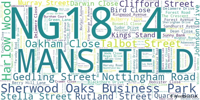
The largest settlements in the NG18 4 postal code are MANSFIELD and Harlow Wood.
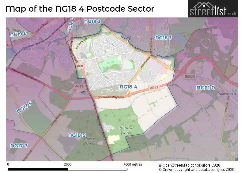
The NG18 4 Postcode shares a border with NG18 1 (MANSFIELD), NG18 3 (MANSFIELD), NG18 5 (MANSFIELD), NG21 0 (Rainworth, Blidworth) and NG18 2 (MANSFIELD).
The sector is within the post town of MANSFIELD.
NG18 4 is a postcode sector within the NG18 postcode district which is within the NG Nottingham postcode area.
The Royal Mail delivery office for the NG18 4 postal sector is the Mansfield Delivery Office.
The area of the NG18 4 postcode sector is 3.50 square miles which is 9.05 square kilometres or 2,236.98 square acres.

Map of the NG18 4 Postcode Sector
Explore the NG18 4 postcode sector by using our free interactive map.
| N | G | 1 | 8 | - | 4 | X | X |
| N | G | 1 | 8 | Space | 4 | Letter | Letter |
Official List of Streets
MANSFIELD (212 Streets)
Harlow Wood (5 Streets)
Sherwood Oaks Business Park (3 Streets)
Unofficial Streets or Alternative Spellings
MANSFIELD
ACORN WAY ALEXANDRA AVENUE ATKIN LANE BIG BARN LANE BRIAR LANE CARTER LANE CAULDWELL ROAD FOREST HILL HIGH OAKHAM ROAD HIGH TOR LITTLE BARN LANE LITTLEWORTH MALTBY ROAD PARK LANE REINDEER STREET ROCK HILL STANLEY ROAD WAVERLEY ROADRainworth
SOUTHWELL ROAD WESTSUTTON-IN-ASHFIELD
SHERWOOD WAY SOUTHWeather Forecast for NG18 4
Press Button to Show Forecast for Mansfield
| Time Period | Icon | Description | Temperature | Rain Probability | Wind |
|---|---|---|---|---|---|
| 18:00 to 21:00 | Cloudy | 8.0°C (feels like 7.0°C) | 4.00% | NE 4 mph | |
| 21:00 to 00:00 | Cloudy | 6.0°C (feels like 5.0°C) | 8.00% | SE 4 mph |
Press Button to Show Forecast for Mansfield
| Time Period | Icon | Description | Temperature | Rain Probability | Wind |
|---|---|---|---|---|---|
| 00:00 to 03:00 | Cloudy | 5.0°C (feels like 3.0°C) | 4.00% | SSW 4 mph | |
| 03:00 to 06:00 | Cloudy | 4.0°C (feels like 1.0°C) | 4.00% | WSW 7 mph | |
| 06:00 to 09:00 | Cloudy | 5.0°C (feels like 1.0°C) | 4.00% | WSW 9 mph | |
| 09:00 to 12:00 | Light rain shower (day) | 7.0°C (feels like 4.0°C) | 35.00% | NW 9 mph | |
| 12:00 to 15:00 | Overcast | 7.0°C (feels like 4.0°C) | 11.00% | NNE 9 mph | |
| 15:00 to 18:00 | Cloudy | 8.0°C (feels like 7.0°C) | 7.00% | NNW 7 mph | |
| 18:00 to 21:00 | Cloudy | 8.0°C (feels like 6.0°C) | 5.00% | NE 7 mph | |
| 21:00 to 00:00 | Cloudy | 5.0°C (feels like 2.0°C) | 5.00% | ENE 7 mph |
Press Button to Show Forecast for Mansfield
| Time Period | Icon | Description | Temperature | Rain Probability | Wind |
|---|---|---|---|---|---|
| 00:00 to 03:00 | Cloudy | 3.0°C (feels like 1.0°C) | 4.00% | NE 4 mph | |
| 03:00 to 06:00 | Clear night | 2.0°C (feels like 0.0°C) | 1.00% | N 4 mph | |
| 06:00 to 09:00 | Sunny day | 2.0°C (feels like 0.0°C) | 1.00% | N 4 mph | |
| 09:00 to 12:00 | Partly cloudy (day) | 6.0°C (feels like 4.0°C) | 2.00% | NE 7 mph | |
| 12:00 to 15:00 | Overcast | 8.0°C (feels like 8.0°C) | 9.00% | ENE 2 mph | |
| 15:00 to 18:00 | Cloudy | 9.0°C (feels like 8.0°C) | 7.00% | ENE 4 mph | |
| 18:00 to 21:00 | Cloudy | 7.0°C (feels like 5.0°C) | 8.00% | ENE 7 mph | |
| 21:00 to 00:00 | Partly cloudy (night) | 5.0°C (feels like 3.0°C) | 10.00% | ENE 4 mph |
Press Button to Show Forecast for Mansfield
| Time Period | Icon | Description | Temperature | Rain Probability | Wind |
|---|---|---|---|---|---|
| 00:00 to 03:00 | Cloudy | 4.0°C (feels like 2.0°C) | 9.00% | NNE 4 mph | |
| 03:00 to 06:00 | Cloudy | 3.0°C (feels like 1.0°C) | 11.00% | NNE 4 mph | |
| 06:00 to 09:00 | Cloudy | 3.0°C (feels like 1.0°C) | 10.00% | NNE 7 mph | |
| 09:00 to 12:00 | Cloudy | 7.0°C (feels like 5.0°C) | 12.00% | ENE 9 mph | |
| 12:00 to 15:00 | Cloudy | 9.0°C (feels like 7.0°C) | 17.00% | E 9 mph | |
| 15:00 to 18:00 | Cloudy | 10.0°C (feels like 8.0°C) | 19.00% | ENE 9 mph | |
| 18:00 to 21:00 | Cloudy | 9.0°C (feels like 6.0°C) | 19.00% | ENE 11 mph | |
| 21:00 to 00:00 | Cloudy | 6.0°C (feels like 4.0°C) | 17.00% | NE 9 mph |
Press Button to Show Forecast for Mansfield
| Time Period | Icon | Description | Temperature | Rain Probability | Wind |
|---|---|---|---|---|---|
| 00:00 to 03:00 | Overcast | 6.0°C (feels like 3.0°C) | 24.00% | NE 11 mph | |
| 03:00 to 06:00 | Light rain | 6.0°C (feels like 3.0°C) | 50.00% | NNE 11 mph | |
| 06:00 to 09:00 | Heavy rain | 7.0°C (feels like 3.0°C) | 76.00% | NNE 13 mph | |
| 09:00 to 12:00 | Heavy rain | 8.0°C (feels like 5.0°C) | 79.00% | NNE 11 mph | |
| 12:00 to 15:00 | Heavy rain | 9.0°C (feels like 6.0°C) | 77.00% | N 11 mph | |
| 15:00 to 18:00 | Light rain | 9.0°C (feels like 7.0°C) | 52.00% | N 11 mph | |
| 18:00 to 21:00 | Light rain shower (day) | 9.0°C (feels like 7.0°C) | 39.00% | N 9 mph | |
| 21:00 to 00:00 | Partly cloudy (night) | 7.0°C (feels like 5.0°C) | 9.00% | SE 7 mph |
Schools and Places of Education Within the NG18 4 Postcode Sector
Berry Hill Primary School
Community school
Black Scotch Lane, Mansfield, Nottinghamshire, NG18 4JW
Head: Mr Ben Trenowden
Ofsted Rating: Good
Inspection: 2020-01-22 (1554 days ago)
Website: Visit Berry Hill Primary School Website
Phone: 01623478477
Number of Pupils: 452
High Oakham Primary School
Community school
Nottingham Road, Mansfield, Nottinghamshire, NG18 4SH
Head: Mrs Stephanie Astle
Ofsted Rating: Good
Inspection: 2022-05-11 (714 days ago)
Website: Visit High Oakham Primary School Website
Phone: 01623461313
Number of Pupils: 452
Portland College
Special post 16 institution
Nottingham Road, Mansfield, Nottinghamshire, NG18 4TJ
Head: Dr Mark Dale
Ofsted Rating: Outstanding
Inspection: 2023-01-19 (461 days ago)
Website: Visit Portland College Website
Phone: 01623499111
Number of Pupils: 0
St Peter's CofE Primary Academy, Mansfield
Academy sponsor led
Bellamy Road, Mansfield, Nottinghamshire, NG18 4LN
Head: Mr James Marshall
Ofsted Rating: Good
Inspection: 2022-04-22 (733 days ago)
Website: Visit St Peter's CofE Primary Academy, Mansfield Website
Phone: 01623489980
Number of Pupils: 214
House Prices in the NG18 4 Postcode Sector
| Type of Property | 2018 Average | 2018 Sales | 2017 Average | 2017 Sales | 2016 Average | 2016 Sales | 2015 Average | 2015 Sales |
|---|---|---|---|---|---|---|---|---|
| Detached | £266,945 | 170 | £253,470 | 148 | £246,337 | 172 | £229,316 | 135 |
| Semi-Detached | £150,591 | 69 | £143,727 | 63 | £140,216 | 77 | £128,855 | 62 |
| Terraced | £127,738 | 40 | £118,519 | 46 | £119,840 | 53 | £110,286 | 48 |
| Flats | £102,123 | 20 | £112,703 | 20 | £105,022 | 25 | £103,636 | 11 |
Important Postcodes NG18 4 in the Postcode Sector
NG18 4GW is the postcode for St. Andrews Healthcare, Sherwood Avenue, Sherwood Oaks Hospital Block A, Sherwood Avenue, Mansfield, Sherwood Oaks Hospital Block B, Sherwood Avenue, Mansfield, BLOCK B, St. Andrews Healthcare, Sherwood Avenue, Sherwood Oaks Hospital Block C, Sherwood Avenue, Mansfield, BLOCK C, St. Andrews Healthcare, Sherwood Avenue, and BLOCK A, St. Andrews Healthcare, Sherwood Avenue
NG18 4HH is the postcode for Forest House, Southwell Road West
NG18 4JU is the postcode for Union of Democratic Mineworkers, The Miners Offices, Berry Hill Lane
NG18 4JW is the postcode for Berry Hill Primary And Nursery School, Black Scotch Lane, BUILDING 4, Berry Hill Primary & Nursery School, Black Scotch Lane, BERRY HILL PRIMARY AND NURSERY SCHOOL, BLACK SCOTCH LANE, MANSFIELD, and Berry Hill Primary & Nursery School, Black Scotch Lane
NG18 4LN is the postcode for CLASSROOM BLOCK, St. Peters C of E Primary & Nursery School, Bellamy Road, St. Peters Primary Academy, Bellamy Road, and St. Peters C of E Primary & Nursery School, Bellamy Road
NG18 4LQ is the postcode for Sovereign House, Sovereign Way
NG18 4RG is the postcode for Mining Heritage Centre, 1 200 Lichfield Lane, MINING HERITAGE CENTRE, The Coal Authority, 200 Lichfield Lane, The Coal Authority, 200 Lichfield Lane, and Mining Information Centre, 2a 200 Lichfield Lane
NG18 4SH is the postcode for High Oakham Primary School, Nottingham Road, FOUNDATION UNIT, High Oakham Primary School, Nottingham Road, and TREE HOUSE BUILDING, High Oakham Primary School, Nottingham Road
NG18 4TJ is the postcode for ELMS, Portland College, Nottingham Road, WOODLANDS, Portland College, Nottingham Road, LAURELS, Portland College, Nottingham Road, CHESTNUTS, Portland College, Nottingham Road, CEDARS, Portland College, Nottingham Road, OAKS, Portland College, Nottingham Road, and BIRCHES, Portland College, Nottingham Road
| The NG18 4 Sector is within these Local Authorities |
|
|---|---|
| The NG18 4 Sector is within these Counties |
|
| The NG18 4 Sector is within these Water Company Areas |
|