The NG18 5 postcode sector is within the county of Nottinghamshire.
Did you know? According to the 2021 Census, the NG18 5 postcode sector is home to a bustling 9,455 residents!
Given that each sector allows for 400 unique postcode combinations. Letters C, I, K, M, O and V are not allowed in the last two letters of a postcode. With 225 postcodes already in use, this leaves 175 units available.
The NG18 5 postal code covers the settlement of MANSFIELD.
The NG18 5 Postcode shares a border with NG17 4 (SUTTON-IN-ASHFIELD), NG17 5 (SUTTON-IN-ASHFIELD, Maun Valley Industrial Park), NG18 1 (MANSFIELD), NG18 4 (MANSFIELD, Harlow Wood), NG19 6 (MANSFIELD), NG21 0 (Rainworth, Blidworth), NG15 9 (Ravenshead) and NG17 7 (Kirkby-in-Ashfield).
The sector is within the post town of MANSFIELD.
NG18 5 is a postcode sector within the NG18 postcode district which is within the NG Nottingham postcode area.
The Royal Mail delivery office for the NG18 5 postal sector is the Mansfield Delivery Office.
The area of the NG18 5 postcode sector is 3.43 square miles which is 8.89 square kilometres or 2,196.40 square acres.

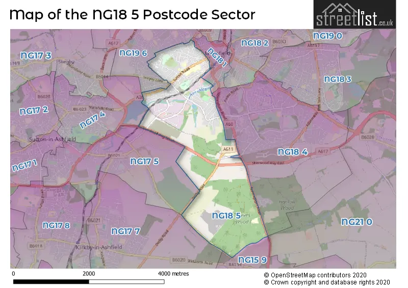
Map of the NG18 5 Postcode Sector
Explore the NG18 5 postcode sector by using our free interactive map.
| N | G | 1 | 8 | - | 5 | X | X |
| N | G | 1 | 8 | Space | 5 | Letter | Letter |
Official List of Streets
MANSFIELD (140 Streets)
Unofficial Streets or Alternative Spellings
Ravenshead
MANSFIELD ROAD CHERRY LANE CLARENCE STREET DRURY DAM VIADUCT KELHAM ROAD KINGS MILL VIADUCT LEVERTON ROAD OAK VIEW PEACOCK STREET QUARRY LANE WALKWAY ROOTH STREET SIBTHORNE STREET TIMBERLAND TRAIL WITHORN MEWS WORSBOROUGH CLOSEHarlow Wood
OAK VIEW RISE THE SPINNEYMANSFIELD
APPIN ROAD ARMSTRONG ROAD BEARDALL STREET BELVEDERE STREET BONINGTON ROAD BOSWORTH STREET CRAIGS GREEN DARLTON STREET GEORGE STREET HARROP WHITE ROAD LICHFIELD AVENUE LICHFIELD CLOSE LISMORE COURT MIDLAND WAY PARK LANE ROSEMARY STREET SHELFORD HILL TUCKERS LANE UNION STREET WALKDEN STREET WATNALL CRESCENT WINKBURN ROADSUTTON-IN-ASHFIELD
CAULDWELL ROAD COXMOOR ROAD HAMILTON ROAD SHERWOOD WAY SOUTHAnnesley
DERBY ROADMANSFIELD,
SKEGBY LANEWeather Forecast for NG18 5
Press Button to Show Forecast for Mansfield
| Time Period | Icon | Description | Temperature | Rain Probability | Wind |
|---|---|---|---|---|---|
| 18:00 to 21:00 | Light rain shower (day) | 7.0°C (feels like 5.0°C) | 35.00% | NW 9 mph | |
| 21:00 to 00:00 | Cloudy | 6.0°C (feels like 4.0°C) | 9.00% | WNW 4 mph |
Press Button to Show Forecast for Mansfield
| Time Period | Icon | Description | Temperature | Rain Probability | Wind |
|---|---|---|---|---|---|
| 00:00 to 03:00 | Clear night | 5.0°C (feels like 2.0°C) | 3.00% | WNW 9 mph | |
| 03:00 to 06:00 | Clear night | 4.0°C (feels like 1.0°C) | 1.00% | NW 9 mph | |
| 06:00 to 09:00 | Sunny day | 3.0°C (feels like 0.0°C) | 0.00% | WNW 7 mph | |
| 09:00 to 12:00 | Partly cloudy (day) | 7.0°C (feels like 4.0°C) | 4.00% | NW 11 mph | |
| 12:00 to 15:00 | Cloudy | 9.0°C (feels like 6.0°C) | 8.00% | NNW 11 mph | |
| 15:00 to 18:00 | Light rain shower (day) | 9.0°C (feels like 6.0°C) | 30.00% | NNW 13 mph | |
| 18:00 to 21:00 | Cloudy | 8.0°C (feels like 5.0°C) | 11.00% | NNW 11 mph | |
| 21:00 to 00:00 | Partly cloudy (night) | 5.0°C (feels like 3.0°C) | 2.00% | N 9 mph |
Press Button to Show Forecast for Mansfield
| Time Period | Icon | Description | Temperature | Rain Probability | Wind |
|---|---|---|---|---|---|
| 00:00 to 03:00 | Clear night | 4.0°C (feels like 2.0°C) | 2.00% | NNW 7 mph | |
| 03:00 to 06:00 | Clear night | 3.0°C (feels like 1.0°C) | 1.00% | NNW 7 mph | |
| 06:00 to 09:00 | Partly cloudy (day) | 4.0°C (feels like 2.0°C) | 3.00% | WNW 4 mph | |
| 09:00 to 12:00 | Cloudy | 7.0°C (feels like 6.0°C) | 5.00% | W 4 mph | |
| 12:00 to 15:00 | Overcast | 10.0°C (feels like 8.0°C) | 10.00% | W 9 mph | |
| 15:00 to 18:00 | Cloudy | 11.0°C (feels like 8.0°C) | 14.00% | W 11 mph | |
| 18:00 to 21:00 | Light rain | 9.0°C (feels like 7.0°C) | 49.00% | WSW 11 mph | |
| 21:00 to 00:00 | Cloudy | 8.0°C (feels like 5.0°C) | 14.00% | WSW 13 mph |
Press Button to Show Forecast for Mansfield
| Time Period | Icon | Description | Temperature | Rain Probability | Wind |
|---|---|---|---|---|---|
| 00:00 to 03:00 | Cloudy | 8.0°C (feels like 5.0°C) | 8.00% | W 13 mph | |
| 03:00 to 06:00 | Cloudy | 8.0°C (feels like 5.0°C) | 6.00% | WNW 11 mph | |
| 06:00 to 09:00 | Cloudy | 8.0°C (feels like 5.0°C) | 6.00% | WNW 13 mph | |
| 09:00 to 12:00 | Cloudy | 10.0°C (feels like 6.0°C) | 5.00% | NW 16 mph | |
| 12:00 to 15:00 | Overcast | 11.0°C (feels like 8.0°C) | 10.00% | NNW 16 mph | |
| 15:00 to 18:00 | Cloudy | 11.0°C (feels like 9.0°C) | 7.00% | NNW 13 mph | |
| 18:00 to 21:00 | Cloudy | 10.0°C (feels like 8.0°C) | 5.00% | N 11 mph | |
| 21:00 to 00:00 | Partly cloudy (night) | 7.0°C (feels like 5.0°C) | 1.00% | N 9 mph |
Press Button to Show Forecast for Mansfield
| Time Period | Icon | Description | Temperature | Rain Probability | Wind |
|---|---|---|---|---|---|
| 00:00 to 03:00 | Cloudy | 6.0°C (feels like 3.0°C) | 5.00% | N 9 mph | |
| 03:00 to 06:00 | Partly cloudy (night) | 5.0°C (feels like 2.0°C) | 2.00% | NNW 7 mph | |
| 06:00 to 09:00 | Partly cloudy (day) | 5.0°C (feels like 3.0°C) | 3.00% | NNW 7 mph | |
| 09:00 to 12:00 | Partly cloudy (day) | 8.0°C (feels like 6.0°C) | 1.00% | N 9 mph | |
| 12:00 to 15:00 | Cloudy | 10.0°C (feels like 9.0°C) | 5.00% | NNW 7 mph | |
| 15:00 to 18:00 | Overcast | 12.0°C (feels like 11.0°C) | 8.00% | NNW 7 mph | |
| 18:00 to 21:00 | Partly cloudy (day) | 12.0°C (feels like 10.0°C) | 2.00% | NNW 7 mph | |
| 21:00 to 00:00 | Partly cloudy (night) | 9.0°C (feels like 7.0°C) | 1.00% | NW 7 mph |
Schools and Places of Education Within the NG18 5 Postcode Sector
APTCOO - A Place to Call Our Own
Other independent special school
Unit 15, Mansfield, Nottinghamshire, NG18 5NF
Head: Ms Michaela Ledsham
Ofsted Rating: Requires improvement
Inspection: 2023-07-06 (285 days ago)
Website: Visit APTCOO - A Place to Call Our Own Website
Phone: 01623629902
Number of Pupils: 20
Sutton Road Primary School
Community school
Moor Lane, Mansfield, Nottinghamshire, NG18 5SF
Head: Mrs Nicola Davies
Ofsted Rating: Good
Inspection: 2019-03-12 (1862 days ago)
Website: Visit Sutton Road Primary School Website
Phone: 01623455920
Number of Pupils: 624
West Nottinghamshire College
Further education
Derby Road, Mansfield, Nottinghamshire, NG18 5BH
Head: Mr Andrew Cropley
Ofsted Rating: Good
Inspection: 2023-03-31 (382 days ago)
Website: Visit West Nottinghamshire College Website
Phone: 01623627191
Number of Pupils: 0
House Prices in the NG18 5 Postcode Sector
| Type of Property | 2018 Average | 2018 Sales | 2017 Average | 2017 Sales | 2016 Average | 2016 Sales | 2015 Average | 2015 Sales |
|---|---|---|---|---|---|---|---|---|
| Detached | £269,121 | 42 | £250,427 | 50 | £225,727 | 46 | £207,987 | 38 |
| Semi-Detached | £122,053 | 55 | £113,717 | 63 | £125,746 | 76 | £122,829 | 40 |
| Terraced | £85,875 | 34 | £87,005 | 43 | £70,883 | 26 | £81,019 | 51 |
| Flats | £57,950 | 11 | £59,166 | 6 | £66,995 | 10 | £63,750 | 4 |
Important Postcodes NG18 5 in the Postcode Sector
NG18 5AJ is the postcode for Oakhurst, High Oakham Road
NG18 5BA is the postcode for Fountaindale School, Nottingham Road, and Harlow Academy, Nottingham Road
NG18 5BH is the postcode for SPORTS BUILDING, Vision West Nottinghamshire College, Derby Road, Vision West Nottinghamshire College, Relish, Derby Road, Vision West Nottinghamshire College, Sports Building, Derby Road, VISUAL ARTS, Vision West Nottinghamshire College, Derby Road, RELISH, Vision West Nottinghamshire College, Derby Road, MAIN & LINKED BLOCKS, Vision West Nottinghamshire College, Derby Road, Vision West Nottinghamshire College, Visual Arts, Derby Road, Vision West Nottinghamshire College, Refined, Derby Road, VISION UNIVERSITY CENTRE, Vision West Nottinghamshire College, Derby Road, Vision West Nottinghamshire College, Main & Linked Blocks, Derby Road, and Vision West Nottinghamshire College, Vision University Centre, Derby Road
NG18 5BJ is the postcode for Mansfield Crematorium, Derby Road
NG18 5BU is the postcode for H.A.R.T., Hamilton Way, Emas Hart, Unit 1 Hamilton Place, and Enterprise Court, Hamilton Way
NG18 5HL is the postcode for East Midlands Ambulance Service NHS Trust, Sutton Road
NG18 5QJ is the postcode for Mansfield Community Hospital, Stockwell Gate, Nottinghamshire County Teaching PCT, Mansfield Community Hospital, and MANSFIELD COMMUNITY HOSPITAL, STOCKWELL GATE, MANSFIELD
NG18 5QL is the postcode for Bracken House, Heather Close
NG18 5SF is the postcode for Sutton Road Primary School, Moor Lane, Sutton Road Primary And Nursery School, Moor Lane, INFANTS SCHOOL, Sutton Road Primary School, Moor Lane, SUTTON ROAD PRIMARY AND NURSERY SCHOOL, MOOR LANE, MANSFIELD, NURSERY, Sutton Road Primary School, Moor Lane, and BN16 SIX CLASS BLOCK, Sutton Road Primary School, Moor Lane
NG18 5SL is the postcode for Titchfield & Oakham Childrens Centre, 73-75 Princes Street
NG18 5TA is the postcode for Former Resource Centre, Dallas Street
NG18 5TF is the postcode for 3-5 Lindsay Close
| The NG18 5 Sector is within these Local Authorities |
|
|---|---|
| The NG18 5 Sector is within these Counties |
|
| The NG18 5 Sector is within these Water Company Areas |
|