The NG19 9 postcode sector is within the county of Nottinghamshire.
Did you know? According to the 2021 Census, the NG19 9 postcode sector is home to a bustling 9,555 residents!
Given that each sector allows for 400 unique postcode combinations. Letters C, I, K, M, O and V are not allowed in the last two letters of a postcode. With 231 postcodes already in use, this leaves 169 units available.
The NG19 9 postal code covers the settlement of Mansfield Woodhouse.
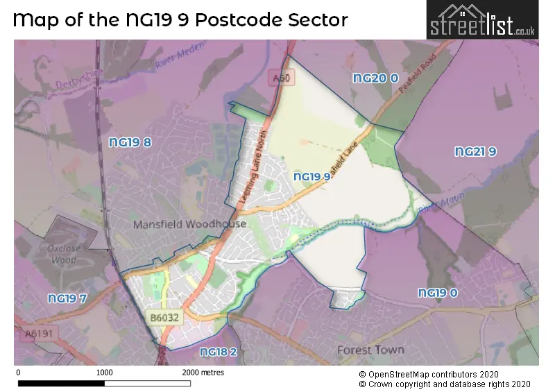
The NG19 9 Postcode shares a border with NG20 0 (Warsop, Church Warsop), NG18 2 (MANSFIELD), NG19 0 (Forest Town), NG19 7 (MANSFIELD, Pleasley, Mansfield Woodhouse), NG19 8 (Mansfield Woodhouse, New Houghton, Pleasley Vale) and NG21 9 (Edwinstowe, Clipstone Village, Kings Clipstone).
The sector is within the post town of MANSFIELD.
NG19 9 is a postcode sector within the NG19 postcode district which is within the NG Nottingham postcode area.
The Royal Mail delivery office for the NG19 9 postal sector is the Mansfield Delivery Office.
The area of the NG19 9 postcode sector is 1.99 square miles which is 5.15 square kilometres or 1,273.16 square acres.
Waterways within the NG19 9 postcode sector include the River Maun.

Map of the NG19 9 Postcode Sector
Explore the NG19 9 postcode sector by using our free interactive map.
| N | G | 1 | 9 | - | 9 | X | X |
| N | G | 1 | 9 | Space | 9 | Letter | Letter |
Official List of Streets
Mansfield Woodhouse (175 Streets)
Unofficial Streets or Alternative Spellings
Mansfield Woodhouse
ANVIL GROVE CASTLE MEWS CASTLE STREET CHURCH STREET DIGBY COURT LEAS ROAD LINCOLN DRIVE PORTLAND STREET RIVERSIDE WAY SANDGATE ROADForest Town
HOLLY ROAD NEW MILL LANE OLD MILL LANE WYCOMBE GRANGEMANSFIELD
WOODHOUSE ROADWeather Forecast for NG19 9
Press Button to Show Forecast for Mansfield Woodhouse
| Time Period | Icon | Description | Temperature | Rain Probability | Wind |
|---|---|---|---|---|---|
| 09:00 to 12:00 | Sunny day | 8.0°C (feels like 6.0°C) | 0.00% | W 4 mph | |
| 12:00 to 15:00 | Cloudy | 11.0°C (feels like 9.0°C) | 9.00% | W 9 mph | |
| 15:00 to 18:00 | Light rain | 10.0°C (feels like 7.0°C) | 55.00% | WSW 11 mph | |
| 18:00 to 21:00 | Light rain | 8.0°C (feels like 6.0°C) | 50.00% | WSW 11 mph | |
| 21:00 to 00:00 | Cloudy | 9.0°C (feels like 6.0°C) | 15.00% | WSW 13 mph |
Press Button to Show Forecast for Mansfield Woodhouse
| Time Period | Icon | Description | Temperature | Rain Probability | Wind |
|---|---|---|---|---|---|
| 00:00 to 03:00 | Cloudy | 9.0°C (feels like 6.0°C) | 9.00% | W 13 mph | |
| 03:00 to 06:00 | Cloudy | 8.0°C (feels like 5.0°C) | 7.00% | WNW 11 mph | |
| 06:00 to 09:00 | Cloudy | 8.0°C (feels like 5.0°C) | 7.00% | WNW 11 mph | |
| 09:00 to 12:00 | Cloudy | 10.0°C (feels like 6.0°C) | 6.00% | NW 16 mph | |
| 12:00 to 15:00 | Cloudy | 11.0°C (feels like 8.0°C) | 7.00% | NNW 13 mph | |
| 15:00 to 18:00 | Cloudy | 12.0°C (feels like 9.0°C) | 5.00% | NNW 13 mph | |
| 18:00 to 21:00 | Cloudy | 10.0°C (feels like 8.0°C) | 7.00% | N 11 mph | |
| 21:00 to 00:00 | Partly cloudy (night) | 7.0°C (feels like 5.0°C) | 5.00% | NNE 9 mph |
Press Button to Show Forecast for Mansfield Woodhouse
| Time Period | Icon | Description | Temperature | Rain Probability | Wind |
|---|---|---|---|---|---|
| 00:00 to 03:00 | Cloudy | 5.0°C (feels like 3.0°C) | 6.00% | N 7 mph | |
| 03:00 to 06:00 | Partly cloudy (night) | 4.0°C (feels like 1.0°C) | 2.00% | NNW 9 mph | |
| 06:00 to 09:00 | Overcast | 4.0°C (feels like 1.0°C) | 8.00% | NNW 9 mph | |
| 09:00 to 12:00 | Cloudy | 7.0°C (feels like 4.0°C) | 5.00% | N 9 mph | |
| 12:00 to 15:00 | Overcast | 9.0°C (feels like 7.0°C) | 8.00% | N 9 mph | |
| 15:00 to 18:00 | Overcast | 11.0°C (feels like 9.0°C) | 8.00% | N 9 mph | |
| 18:00 to 21:00 | Cloudy | 10.0°C (feels like 9.0°C) | 5.00% | NNE 7 mph | |
| 21:00 to 00:00 | Partly cloudy (night) | 8.0°C (feels like 6.0°C) | 1.00% | ENE 4 mph |
Press Button to Show Forecast for Mansfield Woodhouse
| Time Period | Icon | Description | Temperature | Rain Probability | Wind |
|---|---|---|---|---|---|
| 00:00 to 03:00 | Partly cloudy (night) | 6.0°C (feels like 5.0°C) | 1.00% | NNE 4 mph | |
| 03:00 to 06:00 | Cloudy | 6.0°C (feels like 4.0°C) | 5.00% | WNW 4 mph | |
| 06:00 to 09:00 | Overcast | 6.0°C (feels like 5.0°C) | 9.00% | WNW 4 mph | |
| 09:00 to 12:00 | Cloudy | 9.0°C (feels like 7.0°C) | 6.00% | NNE 4 mph | |
| 12:00 to 15:00 | Overcast | 11.0°C (feels like 10.0°C) | 10.00% | NE 7 mph | |
| 15:00 to 18:00 | Overcast | 12.0°C (feels like 11.0°C) | 10.00% | NNE 7 mph | |
| 18:00 to 21:00 | Cloudy | 12.0°C (feels like 10.0°C) | 10.00% | NE 7 mph | |
| 21:00 to 00:00 | Cloudy | 9.0°C (feels like 8.0°C) | 10.00% | ENE 7 mph |
Schools and Places of Education Within the NG19 9 Postcode Sector
Peafield Lane Academy
Academy converter
Litton Road, Mansfield, Nottinghamshire, NG19 9PB
Head: Mr Chris Heathcote
Ofsted Rating: Good
Inspection: 2022-10-05 (561 days ago)
Website: Visit Peafield Lane Academy Website
Phone: 01623460366
Number of Pupils: 327
St Edmund's CofE (C) Primary School
Voluntary controlled school
Church Hill Avenue, Mansfield, Nottinghamshire, NG19 9JU
Head: Mr Nadeem Shah
Ofsted Rating: Good
Inspection: 2021-07-12 (1011 days ago)
Website: Visit St Edmund's CofE (C) Primary School Website
Phone: 01623646624
Number of Pupils: 249
House Prices in the NG19 9 Postcode Sector
| Type of Property | 2018 Average | 2018 Sales | 2017 Average | 2017 Sales | 2016 Average | 2016 Sales | 2015 Average | 2015 Sales |
|---|---|---|---|---|---|---|---|---|
| Detached | £195,154 | 45 | £192,284 | 60 | £180,699 | 70 | £172,911 | 61 |
| Semi-Detached | £124,147 | 61 | £117,245 | 60 | £111,110 | 72 | £110,048 | 62 |
| Terraced | £86,821 | 35 | £81,382 | 36 | £75,056 | 22 | £68,150 | 25 |
| Flats | £76,833 | 3 | £82,333 | 3 | £74,000 | 2 | £111,750 | 2 |
Important Postcodes NG19 9 in the Postcode Sector
NG19 9BG is the postcode for Royal Mail, Mansfield Delivery Office, Old Mill Lane Industrial Estate
NG19 9JU is the postcode for St Edmund's Cofe Primary And Nursery School, Church Hill Avenue, ST EDMUND'S COFE PRIMARY AND NURSERY SCHOOL, CHURCH HILL AVENUE, MANSFIELD WOODHOUSE, and St. Edmunds School, Church Hill Avenue
NG19 9PB is the postcode for ANNEX, Peafield Lane Academy, Litton Road, Peafield Lane Academy, Litton Road, and PEAFIELD LANE ACADEMY, LITTON ROAD, MANSFIELD WOODHOUSE
| The NG19 9 Sector is within these Local Authorities |
|
|---|---|
| The NG19 9 Sector is within these Counties |
|
| The NG19 9 Sector is within these Water Company Areas |
|