The NG2 4 postcode sector is within the county of Nottinghamshire.
Did you know? According to the 2021 Census, the NG2 4 postcode sector is home to a bustling 10,347 residents!
Given that each sector allows for 400 unique postcode combinations. Letters C, I, K, M, O and V are not allowed in the last two letters of a postcode. With 218 postcodes already in use, this leaves 182 units available.
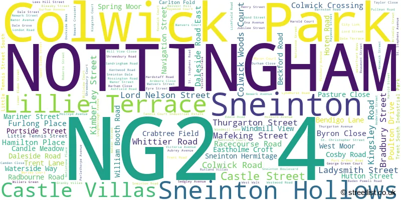
The largest settlement in the NG2 4 postal code is NOTTINGHAM followed by Colwick Park, and Sneinton.
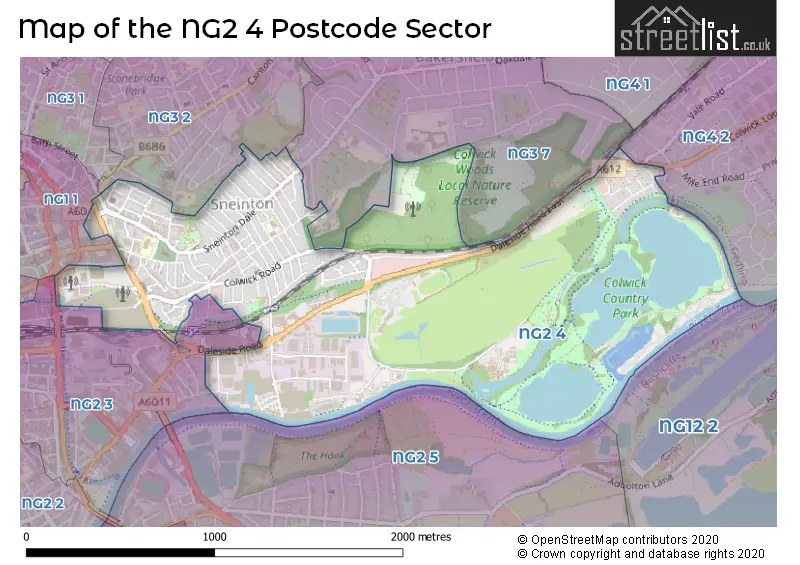
The NG2 4 Postcode shares a border with NG3 2 (NOTTINGHAM, Thorneywood), NG2 3 (NOTTINGHAM), NG12 2 (Radcliffe-on-Trent, Holme Pierrepont), NG2 5 (West Bridgford, NOTTINGHAM), NG3 7 (NOTTINGHAM), NG4 2 (Netherfield, Colwick, Gedling) and NG1 1 (NOTTINGHAM).
The sector is within the post town of NOTTINGHAM.
NG2 4 is a postcode sector within the NG2 postcode district which is within the NG Nottingham postcode area.
The Royal Mail delivery office for the NG2 4 postal sector is the Nottingham South Delivery Office.
The area of the NG2 4 postcode sector is 1.31 square miles which is 3.40 square kilometres or 839.42 square acres.
Waterways within the NG2 4 postcode sector include the Sneiton Arm, Nottingham Canal; Beeston Canal, River Trent.

Map of the NG2 4 Postcode Sector
Explore the NG2 4 postcode sector by using our free interactive map.
| N | G | 2 | - | 4 | X | X |
| N | G | 2 | Space | 4 | Letter | Letter |
Official List of Streets
NOTTINGHAM (110 Streets)
Colwick Park (5 Streets)
Sneinton (3 Streets)
Unofficial Streets or Alternative Spellings
NOTTINGHAM
COLWICK WOODS COURT DALESIDE ROAD EAST ELFORD RISE FRECKINGHAM STREET FREETH STREET HAROLD COURT HIGHCLIFFE ROAD IVATT DRIVE LONDON ROAD LOWER PARLIAMENT STREET MEADOW LANE NOTINTONE PLACE POPLAR STREET RIPON ROAD SOUTHWELL ROAD THORESBY AVENUE BBC ISLAND CHASE PARK DAVIDSON STREET EVELYN STREET LACE WAY LEES HILL FOOTWAY MILE RUN NORTH STREET PORTSIDE SAINT STEPHENS ROAD STANHOPE STREET WARDENS WALK WEST STREETColwick
MILE END ROAD RIVER ROAD VALE GARDENS VALE ROADCarlton
GREENWOOD ROADWeather Forecast for NG2 4
Press Button to Show Forecast for Nottingham Racecourse
| Time Period | Icon | Description | Temperature | Rain Probability | Wind |
|---|---|---|---|---|---|
| 15:00 to 18:00 | Cloudy | 9.0°C (feels like 8.0°C) | 11.00% | NE 4 mph | |
| 18:00 to 21:00 | Partly cloudy (day) | 8.0°C (feels like 7.0°C) | 2.00% | ENE 4 mph | |
| 21:00 to 00:00 | Partly cloudy (night) | 5.0°C (feels like 3.0°C) | 1.00% | E 4 mph |
Press Button to Show Forecast for Nottingham Racecourse
| Time Period | Icon | Description | Temperature | Rain Probability | Wind |
|---|---|---|---|---|---|
| 00:00 to 03:00 | Partly cloudy (night) | 3.0°C (feels like 1.0°C) | 1.00% | NE 4 mph | |
| 03:00 to 06:00 | Partly cloudy (night) | 2.0°C (feels like 0.0°C) | 1.00% | NNE 4 mph | |
| 06:00 to 09:00 | Sunny day | 3.0°C (feels like 0.0°C) | 1.00% | NNE 4 mph | |
| 09:00 to 12:00 | Sunny day | 7.0°C (feels like 5.0°C) | 2.00% | NE 7 mph | |
| 12:00 to 15:00 | Overcast | 9.0°C (feels like 9.0°C) | 10.00% | ENE 4 mph | |
| 15:00 to 18:00 | Cloudy | 10.0°C (feels like 9.0°C) | 9.00% | ENE 4 mph | |
| 18:00 to 21:00 | Cloudy | 8.0°C (feels like 6.0°C) | 11.00% | ENE 7 mph | |
| 21:00 to 00:00 | Partly cloudy (night) | 5.0°C (feels like 3.0°C) | 8.00% | ENE 7 mph |
Press Button to Show Forecast for Nottingham Racecourse
| Time Period | Icon | Description | Temperature | Rain Probability | Wind |
|---|---|---|---|---|---|
| 00:00 to 03:00 | Cloudy | 4.0°C (feels like 2.0°C) | 9.00% | NE 4 mph | |
| 03:00 to 06:00 | Cloudy | 4.0°C (feels like 1.0°C) | 11.00% | NE 4 mph | |
| 06:00 to 09:00 | Cloudy | 4.0°C (feels like 2.0°C) | 10.00% | NE 7 mph | |
| 09:00 to 12:00 | Cloudy | 8.0°C (feels like 6.0°C) | 13.00% | ENE 9 mph | |
| 12:00 to 15:00 | Overcast | 10.0°C (feels like 8.0°C) | 21.00% | ENE 9 mph | |
| 15:00 to 18:00 | Overcast | 11.0°C (feels like 9.0°C) | 22.00% | ENE 11 mph | |
| 18:00 to 21:00 | Cloudy | 9.0°C (feels like 7.0°C) | 16.00% | ENE 11 mph | |
| 21:00 to 00:00 | Cloudy | 7.0°C (feels like 4.0°C) | 15.00% | NE 11 mph |
Press Button to Show Forecast for Nottingham Racecourse
| Time Period | Icon | Description | Temperature | Rain Probability | Wind |
|---|---|---|---|---|---|
| 00:00 to 03:00 | Light rain | 7.0°C (feels like 4.0°C) | 50.00% | NE 11 mph | |
| 03:00 to 06:00 | Light rain | 7.0°C (feels like 4.0°C) | 51.00% | NNE 13 mph | |
| 06:00 to 09:00 | Heavy rain | 8.0°C (feels like 4.0°C) | 76.00% | NNE 13 mph | |
| 09:00 to 12:00 | Heavy rain | 9.0°C (feels like 6.0°C) | 76.00% | NNE 13 mph | |
| 12:00 to 15:00 | Heavy rain | 10.0°C (feels like 8.0°C) | 74.00% | NE 11 mph | |
| 15:00 to 18:00 | Heavy rain | 11.0°C (feels like 8.0°C) | 75.00% | NE 11 mph | |
| 18:00 to 21:00 | Light rain shower (day) | 10.0°C (feels like 8.0°C) | 36.00% | NNE 9 mph | |
| 21:00 to 00:00 | Cloudy | 8.0°C (feels like 6.0°C) | 10.00% | SW 7 mph |
Schools and Places of Education Within the NG2 4 Postcode Sector
Edale Rise Primary & Nursery School
Academy converter
Edale Road, Nottingham, Nottinghamshire, NG2 4HT
Head: Mr Dean-Michael Crosby
Ofsted Rating: Good
Inspection: 2023-06-07 (323 days ago)
Website: Visit Edale Rise Primary & Nursery School Website
Phone: 01159150180
Number of Pupils: 236
William Booth Primary and Nursery School
Academy converter
Notintone Street, Nottingham, Nottinghamshire, NG2 4QF
Head: Mrs Claire Paparozzi
Ofsted Rating: Good
Inspection: 2021-09-30 (938 days ago)
Website: Visit William Booth Primary and Nursery School Website
Phone: 01159155821
Number of Pupils: 233
Windmill L.E.A.D. Academy
Academy sponsor led
Sneinton Boulevard, Nottingham, Nottinghamshire, NG2 4FZ
Head: Claire Caldwell
Ofsted Rating: Good
Inspection: 2019-02-26 (1885 days ago)
Website: Visit Windmill L.E.A.D. Academy Website
Phone: 01159150195
Number of Pupils: 448
House Prices in the NG2 4 Postcode Sector
| Type of Property | 2018 Average | 2018 Sales | 2017 Average | 2017 Sales | 2016 Average | 2016 Sales | 2015 Average | 2015 Sales |
|---|---|---|---|---|---|---|---|---|
| Detached | £224,287 | 19 | £151,000 | 4 | £212,000 | 3 | £119,750 | 4 |
| Semi-Detached | £143,783 | 25 | £130,843 | 21 | £129,253 | 16 | £105,545 | 21 |
| Terraced | £105,499 | 145 | £111,692 | 165 | £96,326 | 141 | £84,870 | 118 |
| Flats | £204,600 | 10 | £219,425 | 10 | £256,222 | 9 | £226,500 | 6 |
Important Postcodes NG2 4 in the Postcode Sector
NG2 4DS is the postcode for Greenway Community & Training Centre, Trent Lane
NG2 4FD is the postcode for Sneinton Hermitage Community Centre, Sneinton Boulevard, and Nottinghamshire County Council, Sneinton Library, Sneinton Boulevard
NG2 4FZ is the postcode for BUILDING 2, Windmill Primary & Nursery School, Sneinton Boulevard, Windmill L.E.A.D Academy, Sneinton Boulevard, and Windmill Primary & Nursery School, Sneinton Boulevard
NG2 4GL is the postcode for Nottingham Academy Primary, Sneinton Boulevard, Nottingham Academy, Sneinton Boulevard, Bellamy Building, Nottingham Academy, Sneinton Boulevard, and Greenwood Dale GM School, Sneinton Boulevard
NG2 4HT is the postcode for EDALE RISE PRIMARY AND NURSERY SCHOOL, EDALE ROAD, Greenwood Infant School, Edale Road, and Edale Rise Primary & Nursery School, Edale Road
NG2 4LA is the postcode for NHS WALK-IN CENTRE, Seaton House, City Link, N H S Direct, Seaton House, City Link, Apex Court, City Link, East Midlands Development Agency, Unit A/2 Apex Court, City Link, and East Midlands Development Agency, Wolds House
NG2 4PJ is the postcode for Sneinton Health Centre, Beaumont Street
NG2 4QB is the postcode for Sneinton C of E Primary School, Windmill Lane, and Greens Mill Science Centre, Windmill Lane
NG2 4QF is the postcode for WILLIAM BOOTH PRIMARY AND NURSERY SCHOOL, NOTINTONE STREET, NOTTINGHAM, William Booth Primary & Nursery School, Notintone Street, Sneinton, William Booth Primary School, Notintone Street, and William Booth Infant School, Notintone Street
| The NG2 4 Sector is within these Local Authorities |
|
|---|---|
| The NG2 4 Sector is within these Counties |
|
| The NG2 4 Sector is within these Water Company Areas |
|
Tourist Attractions within the NG2 4 Postcode Area
We found 1 visitor attractions within the NG2 postcode area
| Green's Windmill |
|---|
| Visitor Centres |
| Heritage / Visitor Centre |
| View Green's Windmill on Google Maps |