The NG2 6 postcode sector is within the county of Nottinghamshire.
Did you know? According to the 2021 Census, the NG2 6 postcode sector is home to a bustling 12,172 residents!
Given that each sector allows for 400 unique postcode combinations. Letters C, I, K, M, O and V are not allowed in the last two letters of a postcode. With 248 postcodes already in use, this leaves 152 units available.
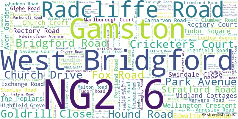
The largest settlements in the NG2 6 postal code are West Bridgford and Gamston.
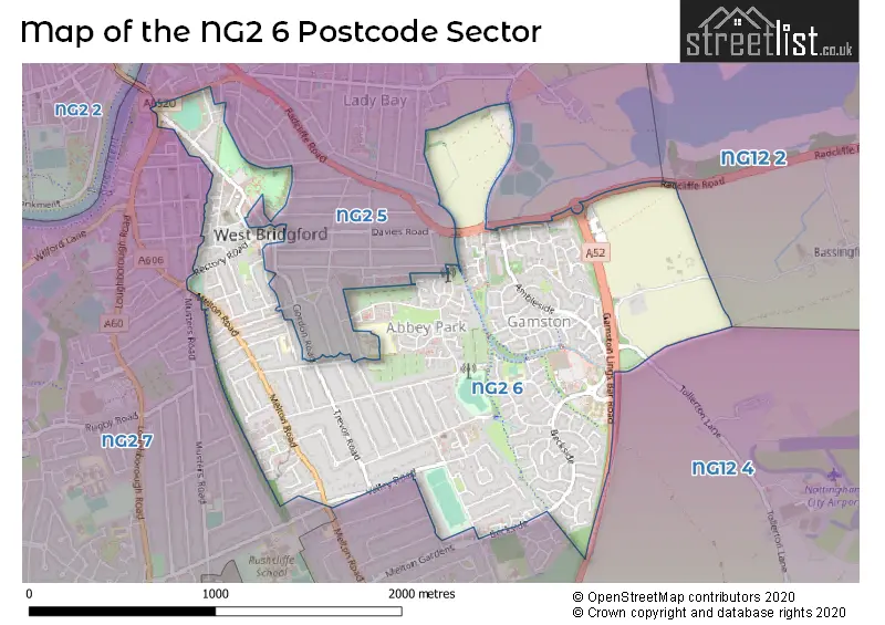
The NG2 6 Postcode shares a border with NG12 2 (Radcliffe-on-Trent, Holme Pierrepont), NG12 4 (Edwalton, Tollerton), NG2 5 (West Bridgford, NOTTINGHAM) and NG2 7 (West Bridgford).
The sector is within the post town of NOTTINGHAM.
NG2 6 is a postcode sector within the NG2 postcode district which is within the NG Nottingham postcode area.
The Royal Mail delivery office for the NG2 6 postal sector is the Nottingham South Delivery Office.
The area of the NG2 6 postcode sector is 1.42 square miles which is 3.69 square kilometres or 911.41 square acres.
The NG2 6 postcode sector is crossed by the A52 Major A road.
Waterways within the NG2 6 postcode sector include the Grantham Canal.

Map of the NG2 6 Postcode Sector
Explore the NG2 6 postcode sector by using our free interactive map.
| N | G | 2 | - | 6 | X | X |
| N | G | 2 | Space | 6 | Letter | Letter |
Official List of Streets
Gamston (43 Streets)
West Bridgford (134 Streets)
Unofficial Streets or Alternative Spellings
West Bridgford
ABBEY ROAD ALBERT ROAD BOUNDARY ROAD CAMBRIDGE ROAD CENTRAL AVENUE COLWICK ROAD DAVIES ROAD ELTHAM ROAD FLORENCE ROAD GEORGE ROAD GORDON ROAD LEVERTON COURT MILLICENT GROVE MILLICENT ROAD MUSTERS ROAD PRIORY ROAD RECTORY COURT REGATTA WAY TEWKESBURY CLOSE VIOLET ROADEdwalton
ALFORD ROAD ASHRIDGE WAY BELFRY WAY CROFT ROAD FIRS ROAD HOLLIES DRIVE MELTON ROADTollerton
TOLLERTON LANE ALFORD COURT ASKHAM COURT COVERDALE WALK GAMSTON LINGS BAR ROAD GAMSTON ROUNDABOUT GRANGE FARM HILTON GRANGE LEAWOOD MANOR LOUGHBOURGH ROAD MUDPIE LANE RIDGWAY CLOSE ST GILES COURT THE GREEN LINE WILLOUGHBY COURT YEW BARROW CLOSEBradmore
LOUGHBOROUGH ROADNOTTINGHAM
LONDON ROADWeather Forecast for NG2 6
Press Button to Show Forecast for Nottingham
| Time Period | Icon | Description | Temperature | Rain Probability | Wind |
|---|---|---|---|---|---|
| 15:00 to 18:00 | Cloudy | 8.0°C (feels like 7.0°C) | 11.00% | NNE 4 mph | |
| 18:00 to 21:00 | Partly cloudy (day) | 8.0°C (feels like 6.0°C) | 2.00% | ENE 7 mph | |
| 21:00 to 00:00 | Partly cloudy (night) | 4.0°C (feels like 3.0°C) | 1.00% | E 4 mph |
Press Button to Show Forecast for Nottingham
| Time Period | Icon | Description | Temperature | Rain Probability | Wind |
|---|---|---|---|---|---|
| 00:00 to 03:00 | Partly cloudy (night) | 2.0°C (feels like 0.0°C) | 1.00% | NE 4 mph | |
| 03:00 to 06:00 | Partly cloudy (night) | 2.0°C (feels like 0.0°C) | 1.00% | NNE 4 mph | |
| 06:00 to 09:00 | Sunny day | 2.0°C (feels like 0.0°C) | 1.00% | NNE 4 mph | |
| 09:00 to 12:00 | Sunny day | 7.0°C (feels like 5.0°C) | 2.00% | NE 7 mph | |
| 12:00 to 15:00 | Overcast | 9.0°C (feels like 8.0°C) | 10.00% | ENE 4 mph | |
| 15:00 to 18:00 | Cloudy | 9.0°C (feels like 9.0°C) | 8.00% | ENE 4 mph | |
| 18:00 to 21:00 | Cloudy | 8.0°C (feels like 6.0°C) | 11.00% | ENE 7 mph | |
| 21:00 to 00:00 | Partly cloudy (night) | 5.0°C (feels like 3.0°C) | 8.00% | ENE 7 mph |
Press Button to Show Forecast for Nottingham
| Time Period | Icon | Description | Temperature | Rain Probability | Wind |
|---|---|---|---|---|---|
| 00:00 to 03:00 | Cloudy | 4.0°C (feels like 2.0°C) | 9.00% | NE 4 mph | |
| 03:00 to 06:00 | Cloudy | 3.0°C (feels like 1.0°C) | 11.00% | NE 4 mph | |
| 06:00 to 09:00 | Cloudy | 4.0°C (feels like 1.0°C) | 10.00% | NE 7 mph | |
| 09:00 to 12:00 | Cloudy | 8.0°C (feels like 6.0°C) | 13.00% | ENE 9 mph | |
| 12:00 to 15:00 | Overcast | 10.0°C (feels like 7.0°C) | 21.00% | ENE 9 mph | |
| 15:00 to 18:00 | Overcast | 11.0°C (feels like 8.0°C) | 22.00% | ENE 11 mph | |
| 18:00 to 21:00 | Cloudy | 9.0°C (feels like 7.0°C) | 16.00% | ENE 11 mph | |
| 21:00 to 00:00 | Cloudy | 7.0°C (feels like 4.0°C) | 15.00% | NE 11 mph |
Press Button to Show Forecast for Nottingham
| Time Period | Icon | Description | Temperature | Rain Probability | Wind |
|---|---|---|---|---|---|
| 00:00 to 03:00 | Light rain | 7.0°C (feels like 4.0°C) | 50.00% | NE 11 mph | |
| 03:00 to 06:00 | Light rain | 7.0°C (feels like 4.0°C) | 51.00% | NNE 13 mph | |
| 06:00 to 09:00 | Heavy rain | 7.0°C (feels like 4.0°C) | 76.00% | NE 13 mph | |
| 09:00 to 12:00 | Heavy rain | 9.0°C (feels like 6.0°C) | 76.00% | NNE 13 mph | |
| 12:00 to 15:00 | Heavy rain | 10.0°C (feels like 8.0°C) | 74.00% | NE 11 mph | |
| 15:00 to 18:00 | Heavy rain | 11.0°C (feels like 8.0°C) | 75.00% | NE 11 mph | |
| 18:00 to 21:00 | Light rain shower (day) | 10.0°C (feels like 7.0°C) | 36.00% | NNE 9 mph | |
| 21:00 to 00:00 | Cloudy | 8.0°C (feels like 6.0°C) | 10.00% | SW 7 mph |
Schools and Places of Education Within the NG2 6 Postcode Sector
Pierrepont Gamston Primary School
Voluntary aided school
Coledale, Nottingham, Nottinghamshire, NG2 6TH
Head: Mrs Claire Bills
Ofsted Rating: Good
Inspection: 2022-05-25 (701 days ago)
Website: Visit Pierrepont Gamston Primary School Website
Phone: 01159819292
Number of Pupils: 316
West Bridgford Infant School
Community school
Avon Gardens, Nottingham, Nottinghamshire, NG2 6BP
Head: Ms Fiona Stevens
Ofsted Rating: Good
Inspection: 2023-11-22 (155 days ago)
Website: Visit West Bridgford Infant School Website
Phone: 01159747885
Number of Pupils: 239
West Bridgford Junior School
Community school
Exchange Road, Nottingham, Nottinghamshire, NG2 6DB
Head: Mr James Willis
Ofsted Rating: Good
Inspection: 2021-11-24 (883 days ago)
Website: Visit West Bridgford Junior School Website
Phone: 01159140201
Number of Pupils: 361
House Prices in the NG2 6 Postcode Sector
| Type of Property | 2018 Average | 2018 Sales | 2017 Average | 2017 Sales | 2016 Average | 2016 Sales | 2015 Average | 2015 Sales |
|---|---|---|---|---|---|---|---|---|
| Detached | £469,741 | 78 | £426,191 | 68 | £397,996 | 67 | £424,189 | 77 |
| Semi-Detached | £310,660 | 53 | £295,587 | 61 | £263,486 | 63 | £257,159 | 47 |
| Terraced | £230,060 | 45 | £248,690 | 58 | £227,385 | 74 | £190,753 | 60 |
| Flats | £162,763 | 40 | £160,365 | 55 | £154,576 | 53 | £153,811 | 39 |
Important Postcodes NG2 6 in the Postcode Sector
NG2 6AH is the postcode for 2-4, Hound Road, West Bridgford
NG2 6AT is the postcode for Nottinghamshire County Council, West Bridgford Library, Bridgford Road, and Nottinghamshire County Council, West Bridgford Library, Bridgford Road, West Bridgford
NG2 6AY is the postcode for West Bridgford Community Hall, Church Drive
NG2 6BJ is the postcode for Trent Bridge House, Fox Road, and NOTTINGHAMSHIRE COUNTY COUNCIL, TRENT BRIDGE HOUSE, FOX ROAD
NG2 6BN is the postcode for West Bridgford Police Station, Rectory Road
NG2 6DB is the postcode for West Bridgford Junior School, Exchange Road
NG2 6EB is the postcode for West Bridgford Junior School Annexe, Tudor Road
NG2 6HY is the postcode for Leawood Manor, Hilton Crescent
NG2 6PR is the postcode for Lings Bar Hospital, Beckside, and Nottinghamshire County Teaching PCT, Lings Bar Hospital
NG2 6PS is the postcode for Gamston Community Hall, Gamston District Centre
NG2 6TH is the postcode for Pierrepont Gamston Primary School, Coledale, and Pierrepont Gamston Primary School, Coledale, West Bridgford
| The NG2 6 Sector is within these Local Authorities |
|
|---|---|
| The NG2 6 Sector is within these Counties |
|
| The NG2 6 Sector is within these Water Company Areas |
|