The NG21 9 postcode sector is within the county of Nottinghamshire.
Did you know? According to the 2021 Census, the NG21 9 postcode sector is home to a bustling 11,852 residents!
Given that each sector allows for 400 unique postcode combinations. Letters C, I, K, M, O and V are not allowed in the last two letters of a postcode. With 258 postcodes already in use, this leaves 142 units available.
The largest settlement in the NG21 9 postal code is Edwinstowe followed by Clipstone Village, and Kings Clipstone.
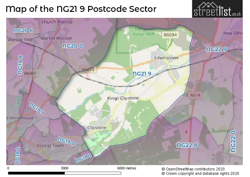
The NG21 9 Postcode shares a border with NG18 3 (MANSFIELD), NG19 9 (Mansfield Woodhouse), NG20 0 (Warsop, Church Warsop), NG21 0 (Rainworth, Blidworth), NG19 0 (Forest Town), NG22 8 (Bilsthorpe, Farnsfield, Kirklington) and NG22 9 (New Ollerton, Ollerton, Boughton).
The sector is within the post town of MANSFIELD.
NG21 9 is a postcode sector within the NG21 postcode district which is within the NG Nottingham postcode area.
The Royal Mail delivery office for the NG21 9 postal sector is the Mansfield Delivery Office.
The area of the NG21 9 postcode sector is 11.88 square miles which is 30.77 square kilometres or 7,602.48 square acres.
Waterways within the NG21 9 postcode sector include the River Maun.

Map of the NG21 9 Postcode Sector
Explore the NG21 9 postcode sector by using our free interactive map.
| N | G | 2 | 1 | - | 9 | X | X |
| N | G | 2 | 1 | Space | 9 | Letter | Letter |
Official List of Streets
Edwinstowe (92 Streets)
Kings Clipstone (13 Streets)
Clipstone Village (72 Streets)
Unofficial Streets or Alternative Spellings
Ollerton
WORKSOP ROAD ADVENTURE CYCLE TRAIL ADVENTURE CYCLE TRAIL / FAMILY CYCLE ROUTE BEVAN PLACE BROAD DRIVE CHESTNUT SCREED CHURCH FARM CLIPSTONE DRIVE CROCK DALE DRIVE FAMILY CYCLE ROUTE FARM ROAD GREEN DRIVE HANGER HILL DRIVE MAID MARRION DRIVE NARROW DRIVE NEW BUILDINGS DRIVE NIGHTINGDALE CLOSE OLD STATION YARD PEAFIELD ROAD PERLTHORPE CLOSE STATION LANE SWINECOTE ROADForest Town
CLIPSTONE DRIVE CLIPSTONE ROAD EAST GARIBALDI ROAD GREENWAYWarsop
FOREST ROADMansfield Woodhouse
PEAFIELD LANEWeather Forecast for NG21 9
Press Button to Show Forecast for Sherwood Pines Forest Park
| Time Period | Icon | Description | Temperature | Rain Probability | Wind |
|---|---|---|---|---|---|
| 03:00 to 06:00 | Partly cloudy (night) | 3.0°C (feels like 0.0°C) | 1.00% | NW 7 mph | |
| 06:00 to 09:00 | Partly cloudy (day) | 4.0°C (feels like 1.0°C) | 1.00% | NNW 7 mph | |
| 09:00 to 12:00 | Cloudy | 7.0°C (feels like 4.0°C) | 8.00% | N 11 mph | |
| 12:00 to 15:00 | Cloudy | 9.0°C (feels like 7.0°C) | 5.00% | N 11 mph | |
| 15:00 to 18:00 | Cloudy | 10.0°C (feels like 8.0°C) | 7.00% | N 9 mph | |
| 18:00 to 21:00 | Cloudy | 9.0°C (feels like 7.0°C) | 8.00% | NNE 7 mph | |
| 21:00 to 00:00 | Cloudy | 6.0°C (feels like 5.0°C) | 8.00% | NE 4 mph |
Press Button to Show Forecast for Sherwood Pines Forest Park
| Time Period | Icon | Description | Temperature | Rain Probability | Wind |
|---|---|---|---|---|---|
| 00:00 to 03:00 | Overcast | 5.0°C (feels like 4.0°C) | 9.00% | NNE 4 mph | |
| 03:00 to 06:00 | Overcast | 5.0°C (feels like 3.0°C) | 9.00% | NNW 4 mph | |
| 06:00 to 09:00 | Overcast | 5.0°C (feels like 3.0°C) | 10.00% | N 7 mph | |
| 09:00 to 12:00 | Overcast | 6.0°C (feels like 4.0°C) | 13.00% | NNE 7 mph | |
| 12:00 to 15:00 | Overcast | 8.0°C (feels like 6.0°C) | 12.00% | NNE 9 mph | |
| 15:00 to 18:00 | Overcast | 9.0°C (feels like 7.0°C) | 14.00% | NE 9 mph | |
| 18:00 to 21:00 | Cloudy | 8.0°C (feels like 6.0°C) | 9.00% | NE 7 mph | |
| 21:00 to 00:00 | Cloudy | 5.0°C (feels like 3.0°C) | 8.00% | NE 4 mph |
Press Button to Show Forecast for Sherwood Pines Forest Park
| Time Period | Icon | Description | Temperature | Rain Probability | Wind |
|---|---|---|---|---|---|
| 00:00 to 03:00 | Cloudy | 4.0°C (feels like 2.0°C) | 7.00% | NNE 4 mph | |
| 03:00 to 06:00 | Cloudy | 3.0°C (feels like 1.0°C) | 10.00% | NNW 4 mph | |
| 06:00 to 09:00 | Overcast | 4.0°C (feels like 3.0°C) | 16.00% | WNW 4 mph | |
| 09:00 to 12:00 | Overcast | 6.0°C (feels like 5.0°C) | 24.00% | NW 4 mph | |
| 12:00 to 15:00 | Light rain | 7.0°C (feels like 5.0°C) | 59.00% | NNW 7 mph | |
| 15:00 to 18:00 | Light rain | 8.0°C (feels like 6.0°C) | 55.00% | ESE 7 mph | |
| 18:00 to 21:00 | Light rain | 8.0°C (feels like 7.0°C) | 53.00% | NNW 4 mph | |
| 21:00 to 00:00 | Light rain | 7.0°C (feels like 5.0°C) | 39.00% | N 4 mph |
Press Button to Show Forecast for Sherwood Pines Forest Park
| Time Period | Icon | Description | Temperature | Rain Probability | Wind |
|---|---|---|---|---|---|
| 00:00 to 03:00 | Overcast | 6.0°C (feels like 4.0°C) | 11.00% | ENE 4 mph | |
| 03:00 to 06:00 | Overcast | 6.0°C (feels like 3.0°C) | 10.00% | NNW 7 mph | |
| 06:00 to 09:00 | Overcast | 6.0°C (feels like 4.0°C) | 11.00% | N 7 mph | |
| 09:00 to 12:00 | Cloudy | 8.0°C (feels like 6.0°C) | 7.00% | NNE 9 mph | |
| 12:00 to 15:00 | Overcast | 10.0°C (feels like 8.0°C) | 20.00% | NNE 9 mph | |
| 15:00 to 18:00 | Light rain | 10.0°C (feels like 8.0°C) | 46.00% | NNE 11 mph | |
| 18:00 to 21:00 | Cloudy | 9.0°C (feels like 7.0°C) | 6.00% | NNE 9 mph | |
| 21:00 to 00:00 | Partly cloudy (night) | 6.0°C (feels like 4.0°C) | 4.00% | NNE 7 mph |
Schools and Places of Education Within the NG21 9 Postcode Sector
King Edwin Primary and Nursery School
Community school
Fourth Avenue, Mansfield, Nottinghamshire, NG21 9NS
Head: Mr Andy Callaghan-Wetton
Ofsted Rating: Good
Inspection: 2018-07-04 (2117 days ago)
Website: Visit King Edwin Primary and Nursery School Website
Phone: 01623822111
Number of Pupils: 464
Samuel Barlow Primary Academy
Academy sponsor led
Church Road, Mansfield, Nottinghamshire, NG21 9DF
Head: Mr Gareth Letton
Ofsted Rating: Good
Inspection: 2022-01-19 (822 days ago)
Website: Visit Samuel Barlow Primary Academy Website
Phone: 01623479033
Number of Pupils: 263
St. Mary's Church of England Primary School, Edwinstowe
Academy converter
Paddock Close, Mansfield, Nottinghamshire, NG21 9LP
Head: Miss Maria Parkin
Ofsted Rating: Good
Inspection: 2023-05-18 (338 days ago)
Website: Visit St. Mary's Church of England Primary School, Edwinstowe Website
Phone: 01623822518
Number of Pupils: 110
House Prices in the NG21 9 Postcode Sector
| Type of Property | 2018 Average | 2018 Sales | 2017 Average | 2017 Sales | 2016 Average | 2016 Sales | 2015 Average | 2015 Sales |
|---|---|---|---|---|---|---|---|---|
| Detached | £240,434 | 90 | £228,811 | 105 | £216,261 | 103 | £205,650 | 80 |
| Semi-Detached | £143,266 | 89 | £132,663 | 80 | £126,274 | 71 | £122,728 | 64 |
| Terraced | £114,969 | 45 | £118,506 | 57 | £111,732 | 81 | £108,869 | 63 |
| Flats | £83,720 | 10 | £99,214 | 7 | £79,700 | 5 | £73,500 | 2 |
Important Postcodes NG21 9 in the Postcode Sector
NG21 9DA is the postcode for Clipstone Health Centre, First Avenue
NG21 9DF is the postcode for Samuel Barlow Primary Academy, Church Road, Clipstone Village, and Samuel Barlow Primary School, Church Road
NG21 9HN is the postcode for THE FOREST TABLE, Sherwood Forest Visitor Centre, Sherwood Forest Country Park
NG21 9LP is the postcode for St. Marys School, Paddock Close
NG21 9NS is the postcode for King Edwin Primary School, Fourth Avenue, Edwinstowe, and King Edwin Primary School, Fourth Avenue
NG21 9QA is the postcode for Nottinghamshire County Council, The Big House, Church Street
NG21 9QS is the postcode for MAJOR OAK MEDICAL PRACTISE, Central Nottinghamshire Healthcare NHS Trust, Edwinstowe Health Centre, High Street, Edwinstowe Library, High Street, The Old Library, High Street, and Central Nottinghamshire Healthcare NHS Trust, Edwinstowe Health Centre, High Street
NG21 9RN is the postcode for Sherwood Forest Art And Craft Centre, Forest Corner
| The NG21 9 Sector is within these Local Authorities |
|
|---|---|
| The NG21 9 Sector is within these Counties |
|
| The NG21 9 Sector is within these Water Company Areas |
|
Tourist Attractions within the NG21 9 Postcode Area
We found 3 visitor attractions within the NG21 postcode area
| Sherwood Pines Forest Park |
|---|
| Country Parks |
| Country Park |
| View Sherwood Pines Forest Park on Google Maps |
| Sherwood Forest Fun Park |
| Leisure / Theme Parks |
| Leisure / Theme Park |
| View Sherwood Forest Fun Park on Google Maps |
| Go Ape! Tree Top Adventure - Sherwood |
| Country Parks |
| Country Park |
| View Go Ape! Tree Top Adventure - Sherwood on Google Maps |