The NG25 postcode district is a postal district located in the NG Nottingham postcode area with a population of 9,165 residents according to the 2021 England and Wales Census.
The area of the NG25 postcode district is 21.25 square miles which is 55.03 square kilometres or 13,598.19 acres.
Currently, the NG25 district has about 286 postcode units spread across 1 geographic postcode sectors.
Given that each sector allows for 400 unique postcode combinations, the district has a capacity of 400 postcodes. With 286 postcodes already in use, this leaves 114 units available.
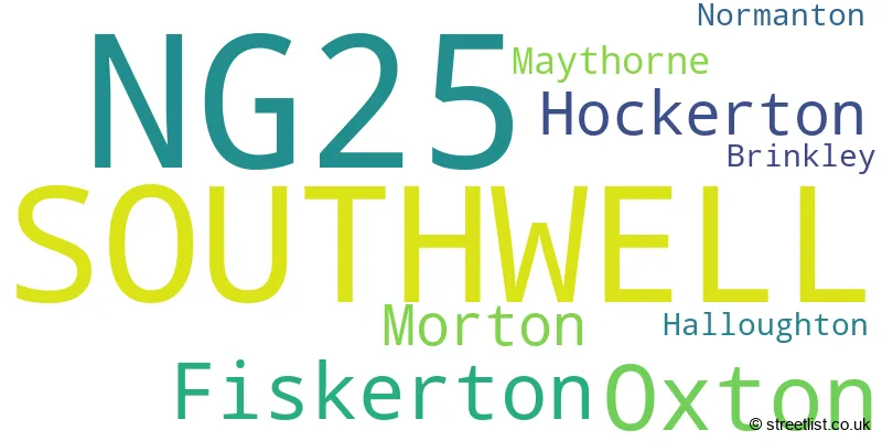
The largest settlement in the NG25 postal code is SOUTHWELL followed by Fiskerton, and Oxton.
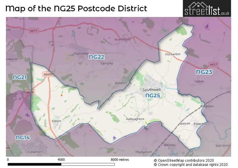
The NG25 Postcode shares a border with NG21 (Rainworth, Edwinstowe, Clipstone Village), NG22 (New Ollerton, Bilsthorpe, Tuxford), NG23 (Collingham, Long Bennington, Sutton-on-Trent) and NG14 (Calverton, Burton Joyce, Lowdham).
The primary settlement in the NG25 postcode district is Southwell, located in the county of Nottinghamshire in England. Other significant settlements in the district include Brinkley, Fiskerton, Halloughton, Hockerton, Maythorne, Morton, Normanton, and Oxton. Southwell is the most significant settlement, with the highest count, and is also the post town for the NG25 postcode district.
For the district NG25, we have data on 1 postcode sectors. Here's a breakdown: The sector NG25 0, covers Southwell in Nottinghamshire.
NG25 Postcode Sectors

Map of the NG25 Postcode District
Explore the NG25 postcode district by using our free interactive map.
When it comes to local government, postal geography often disregards political borders. However, for a breakdown in the NG25 District: the district mostly encompasses the Newark and Sherwood District area with a total of 288 postcodes.
Recent House Sales in NG25
| Date | Price | Address |
|---|---|---|
| 04/10/2023 | £431,000 | Nursery End, Southwell, NG25 0BY |
| 20/09/2023 | £193,000 | Sheppards Row, Southwell, NG25 0AB |
| 15/09/2023 | £375,000 | Byron Gardens, Southwell, NG25 0DW |
| 05/09/2023 | £575,000 | Hopewell Rise, Southwell, NG25 0NX |
| 30/08/2023 | £430,000 | Glenfields, Southwell, NG25 0AS |
| 30/08/2023 | £625,000 | Byron Gardens, Southwell, NG25 0DW |
| 22/08/2023 | £640,000 | Humberstone Road, Southwell, NG25 0FE |
| 18/08/2023 | £300,000 | Station Road, Southwell, NG25 0GL |
| 09/08/2023 | £830,000 | Back Lane, Morton, Southwell, NG25 0UU |
| 07/08/2023 | £360,000 | Springfield Road, Southwell, NG25 0BS |
Weather Forecast for NG25
Press Button to Show Forecast for Southwell
| Time Period | Icon | Description | Temperature | Rain Probability | Wind |
|---|---|---|---|---|---|
| 21:00 to 00:00 | Cloudy | 6.0°C (feels like 5.0°C) | 8.00% | SE 4 mph |
Press Button to Show Forecast for Southwell
| Time Period | Icon | Description | Temperature | Rain Probability | Wind |
|---|---|---|---|---|---|
| 00:00 to 03:00 | Cloudy | 5.0°C (feels like 3.0°C) | 4.00% | SSW 4 mph | |
| 03:00 to 06:00 | Cloudy | 4.0°C (feels like 1.0°C) | 4.00% | WSW 7 mph | |
| 06:00 to 09:00 | Cloudy | 5.0°C (feels like 1.0°C) | 4.00% | WSW 11 mph | |
| 09:00 to 12:00 | Cloudy | 7.0°C (feels like 4.0°C) | 50.00% | WNW 11 mph | |
| 12:00 to 15:00 | Cloudy | 7.0°C (feels like 5.0°C) | 51.00% | N 9 mph | |
| 15:00 to 18:00 | Cloudy | 8.0°C (feels like 7.0°C) | 7.00% | NNW 4 mph | |
| 18:00 to 21:00 | Partly cloudy (day) | 8.0°C (feels like 6.0°C) | 1.00% | NE 7 mph | |
| 21:00 to 00:00 | Cloudy | 4.0°C (feels like 2.0°C) | 4.00% | ENE 4 mph |
Press Button to Show Forecast for Southwell
| Time Period | Icon | Description | Temperature | Rain Probability | Wind |
|---|---|---|---|---|---|
| 00:00 to 03:00 | Partly cloudy (night) | 2.0°C (feels like 0.0°C) | 1.00% | NNE 4 mph | |
| 03:00 to 06:00 | Clear night | 1.0°C (feels like -1.0°C) | 1.00% | NNW 4 mph | |
| 06:00 to 09:00 | Partly cloudy (day) | 2.0°C (feels like 0.0°C) | 1.00% | N 4 mph | |
| 09:00 to 12:00 | Partly cloudy (day) | 7.0°C (feels like 5.0°C) | 2.00% | NE 7 mph | |
| 12:00 to 15:00 | Cloudy | 9.0°C (feels like 8.0°C) | 10.00% | ENE 4 mph | |
| 15:00 to 18:00 | Cloudy | 9.0°C (feels like 8.0°C) | 9.00% | NE 4 mph | |
| 18:00 to 21:00 | Partly cloudy (day) | 7.0°C (feels like 6.0°C) | 7.00% | ENE 4 mph | |
| 21:00 to 00:00 | Partly cloudy (night) | 5.0°C (feels like 3.0°C) | 7.00% | ENE 4 mph |
Press Button to Show Forecast for Southwell
| Time Period | Icon | Description | Temperature | Rain Probability | Wind |
|---|---|---|---|---|---|
| 00:00 to 03:00 | Cloudy | 4.0°C (feels like 2.0°C) | 9.00% | NE 4 mph | |
| 03:00 to 06:00 | Cloudy | 3.0°C (feels like 1.0°C) | 11.00% | NE 4 mph | |
| 06:00 to 09:00 | Cloudy | 4.0°C (feels like 1.0°C) | 10.00% | NE 7 mph | |
| 09:00 to 12:00 | Cloudy | 8.0°C (feels like 6.0°C) | 12.00% | ENE 9 mph | |
| 12:00 to 15:00 | Overcast | 10.0°C (feels like 7.0°C) | 21.00% | ENE 9 mph | |
| 15:00 to 18:00 | Overcast | 11.0°C (feels like 8.0°C) | 22.00% | ENE 11 mph | |
| 18:00 to 21:00 | Cloudy | 9.0°C (feels like 6.0°C) | 18.00% | ENE 11 mph | |
| 21:00 to 00:00 | Cloudy | 7.0°C (feels like 4.0°C) | 15.00% | NE 9 mph |
Press Button to Show Forecast for Southwell
| Time Period | Icon | Description | Temperature | Rain Probability | Wind |
|---|---|---|---|---|---|
| 00:00 to 03:00 | Cloudy | 7.0°C (feels like 4.0°C) | 22.00% | NE 11 mph | |
| 03:00 to 06:00 | Light rain | 7.0°C (feels like 3.0°C) | 51.00% | NNE 13 mph | |
| 06:00 to 09:00 | Heavy rain | 7.0°C (feels like 4.0°C) | 77.00% | NNE 13 mph | |
| 09:00 to 12:00 | Heavy rain | 9.0°C (feels like 6.0°C) | 77.00% | NNE 13 mph | |
| 12:00 to 15:00 | Heavy rain | 10.0°C (feels like 8.0°C) | 75.00% | NE 11 mph | |
| 15:00 to 18:00 | Heavy rain shower (day) | 10.0°C (feels like 8.0°C) | 55.00% | ENE 11 mph | |
| 18:00 to 21:00 | Light rain shower (day) | 9.0°C (feels like 7.0°C) | 38.00% | NE 9 mph | |
| 21:00 to 00:00 | Cloudy | 8.0°C (feels like 6.0°C) | 11.00% | SW 7 mph |
Where is the NG25 Postcode District?
The postcode district NG25 is located in the town of Southwell. Southwell is situated near several nearby towns. To the east, there is Newark which is approximately 3.47 miles away. Nottingham is located to the southwest, about 9.69 miles from Southwell. Mansfield is in the northwest and is approximately 9.78 miles away. Sutton-in-Ashfield is situated to the west, about 12.39 miles from Southwell. Lastly, Worksop is located to the north and is approximately 16.55 miles away. Additionally, Southwell is approximately 114.02 miles away from the center of London.
The district is within the post town of SOUTHWELL.
The sector has postcodes within the nation of England.
The NG25 Postcode District is in the North Nottinghamshire region of Derbyshire and Nottinghamshire within the East Midlands (England).
Postcode Sectors within the NG25 District
| Postcode Sector | Delivery Office |
|---|---|
| NG25 0 | Newark Delivery Office |
| N | G | 2 | 5 | - | X | X | X |
| N | G | 2 | 5 | Space | Numeric | Letter | Letter |
Tourist Attractions within the Postcode Area
We found 2 visitor attractions within the NG25 postcode area
| Workhouse, The |
|---|
| Visitor Centres |
| Heritage / Visitor Centre |
| View Workhouse, The on Google Maps |
| Southwell Minster |
| Places of Worship |
| Place of Worship (still in use) |
| View Southwell Minster on Google Maps |
Current Monthly Rental Prices
| # Bedrooms | Min Price | Max Price | Avg Price |
|---|---|---|---|
| 1 | £825 | £825 | £825 |
| 2 | £895 | £895 | £895 |
| 3 | £1,000 | £1,250 | £1,100 |
| 4 | £1,200 | £1,300 | £1,250 |
| 5 | £1,500 | £1,500 | £1,500 |
Current House Prices
| # Bedrooms | Min Price | Max Price | Avg Price |
|---|---|---|---|
| £100,000 | £100,000 | £100,000 | |
| 1 | £175,000 | £225,000 | £200,000 |
| 2 | £190,000 | £425,000 | £294,745 |
| 3 | £165,000 | £685,000 | £368,346 |
| 4 | £325,000 | £850,000 | £527,172 |
| 5 | £499,950 | £1,500,000 | £734,995 |
| 6 | £1,200,000 | £1,200,000 | £1,200,000 |
Estate Agents who Operate in the NG25 District
| Logo | Name | Brand Name | Address | Contact Number | Total Properties |
|---|---|---|---|---|---|
 | Southwell | Alasdair Morrison and Partners | 22 King Street, Southwell, NG25 0EN | 01636 556288 | 23 |
 | Southwell | Gascoines | 1 Church Street, Southwell, NG25 0HQ | 01636 556165 | 20 |
 | Southwell | Richard Watkinson & Partners | 20 King Street, Southwell, NG25 0EH | 01636 555784 | 13 |
 | Southwell | Kirkland & Lane | North Muskham Prebend Church Street, Southwell, NG25 0HQ | 01636 558548 | 8 |
 | East Midlands | eXp UK | 1 Northumberland Avenue, Trafalgar Square, London, WC2N 5BW | 03304 609968 | 4 |
| Type of Property | 2018 Average | 2018 Sales | 2017 Average | 2017 Sales | 2016 Average | 2016 Sales | 2015 Average | 2015 Sales |
|---|---|---|---|---|---|---|---|---|
| Detached | £441,203 | 73 | £374,716 | 94 | £395,397 | 92 | £363,042 | 71 |
| Semi-Detached | £272,471 | 39 | £219,960 | 35 | £235,042 | 41 | £218,405 | 26 |
| Terraced | £298,665 | 33 | £311,108 | 23 | £177,814 | 25 | £206,262 | 13 |
| Flats | £175,859 | 11 | £220,392 | 22 | £147,519 | 24 | £194,150 | 10 |