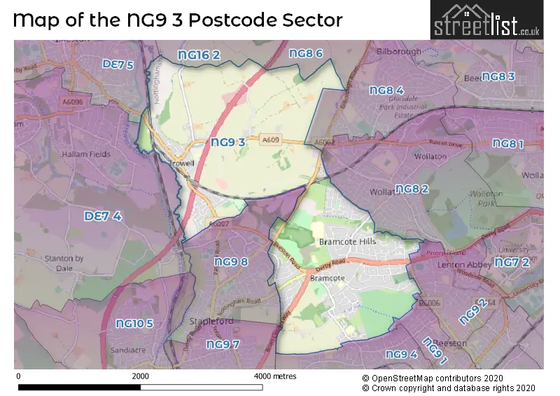
The NG9 3 postcode sector stands on the Derbyshire and Nottinghamshire border.
Did you know? According to the 2021 Census, the NG9 3 postcode sector is home to a bustling 11,390 residents!
Given that each sector allows for 400 unique postcode combinations. Letters C, I, K, M, O and V are not allowed in the last two letters of a postcode. With 247 postcodes already in use, this leaves 153 units available.
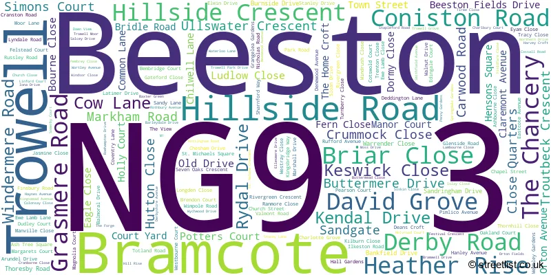
The largest settlement in the NG9 3 postal code is Bramcote followed by Trowell, and Beeston.
The NG9 3 Postcode shares a border with NG8 4 (NOTTINGHAM), NG9 2 (Beeston), NG9 4 (Beeston), NG9 7 (Stapleford), DE7 4 (ILKESTON, Stanton-by-Dale, Quarry Hill Industrial Estate), DE7 5 (ILKESTON), NG8 2 (NOTTINGHAM, Wollaton), NG8 6 (NOTTINGHAM, Strelley), NG9 1 (Beeston), NG9 8 (Stapleford) and NG16 2 (Kimberley, Newthorpe, Giltbrook).
The sector is within the post town of NOTTINGHAM.
NG9 3 is a postcode sector within the NG9 postcode district which is within the NG Nottingham postcode area.
The Royal Mail delivery office for the NG9 3 postal sector is the Beeston Delivery Office.
The area of the NG9 3 postcode sector is 4.34 square miles which is 11.24 square kilometres or 2,777.35 square acres.
The NG9 3 postcode sector is crossed by the M1 motorway.
The NG9 3 postcode sector is crossed by the A52 Major A road.
Waterways within the NG9 3 postcode sector include the Tottle Brook, Nottingham Canal, River Erewash, disused Nottingham Canal.

Map of the NG9 3 Postcode Sector
Explore the NG9 3 postcode sector by using our free interactive map.
| N | G | 9 | - | 3 | X | X |
| N | G | 9 | Space | 3 | Letter | Letter |
Official List of Streets
Bramcote (98 Streets)
Trowell (39 Streets)
Beeston (28 Streets)
Unofficial Streets or Alternative Spellings
Beeston
ANDERSON CRESCENT BRAMCOTE DRIVE BRAMCOTE DRIVE WEST BRAMCOTE ROAD CLIFFORD AVENUE COTSWOLD COURT FARFIELD AVENUE HOLDEN ROAD LOUIS AVENUE POTTERS COURT SIMONS COURT WINCHESTER AVENUE WOLLATON ROADBramcote
HOLYROOD COURT PEARSON COURT THE VIEW WESTBOURNE COURT BRAMCOTE ISLAND BRENDAN COURT BRIAN CLOUGH WAY CHAPEL MEWS COURT CRANBOURNE CLOSE HILL FARM COURT LOWES COURT MOOR FARM INN LANE NECTAR GARDENS NEED WOOD AVENUE PEACHE WAY PIT LANE SIDINGS LANE SPRING DALE GARDENS SWANSEA BRIDGE THE BOARDS THE JARDINES THE LAWNS THE PINESNOTTINGHAM
APPLEDORE AVENUE BRAMCOTE LANE FYLINGDALE WAYStapleford
BAULK LANE CENTRAL AVENUE NOTTINGHAM ROADWeather Forecast for NG9 3
Press Button to Show Forecast for Stapleford
| Time Period | Icon | Description | Temperature | Rain Probability | Wind |
|---|---|---|---|---|---|
| 00:00 to 03:00 | Partly cloudy (night) | 5.0°C (feels like 3.0°C) | 0.00% | SSW 4 mph | |
| 03:00 to 06:00 | Cloudy | 3.0°C (feels like 1.0°C) | 3.00% | WSW 7 mph | |
| 06:00 to 09:00 | Cloudy | 4.0°C (feels like 1.0°C) | 48.00% | W 9 mph | |
| 09:00 to 12:00 | Cloudy | 7.0°C (feels like 4.0°C) | 44.00% | W 9 mph | |
| 12:00 to 15:00 | Overcast | 8.0°C (feels like 5.0°C) | 17.00% | N 9 mph | |
| 15:00 to 18:00 | Cloudy | 8.0°C (feels like 7.0°C) | 12.00% | NNE 7 mph | |
| 18:00 to 21:00 | Cloudy | 8.0°C (feels like 7.0°C) | 6.00% | ENE 7 mph | |
| 21:00 to 00:00 | Cloudy | 5.0°C (feels like 4.0°C) | 7.00% | E 4 mph |
Press Button to Show Forecast for Stapleford
| Time Period | Icon | Description | Temperature | Rain Probability | Wind |
|---|---|---|---|---|---|
| 00:00 to 03:00 | Partly cloudy (night) | 4.0°C (feels like 2.0°C) | 1.00% | ENE 4 mph | |
| 03:00 to 06:00 | Partly cloudy (night) | 2.0°C (feels like 1.0°C) | 1.00% | NNE 4 mph | |
| 06:00 to 09:00 | Partly cloudy (day) | 3.0°C (feels like 1.0°C) | 1.00% | NNE 4 mph | |
| 09:00 to 12:00 | Cloudy | 7.0°C (feels like 5.0°C) | 4.00% | ENE 7 mph | |
| 12:00 to 15:00 | Overcast | 9.0°C (feels like 8.0°C) | 9.00% | ENE 4 mph | |
| 15:00 to 18:00 | Cloudy | 9.0°C (feels like 9.0°C) | 8.00% | ENE 4 mph | |
| 18:00 to 21:00 | Cloudy | 8.0°C (feels like 6.0°C) | 11.00% | ENE 9 mph | |
| 21:00 to 00:00 | Cloudy | 6.0°C (feels like 4.0°C) | 10.00% | ENE 7 mph |
Press Button to Show Forecast for Stapleford
| Time Period | Icon | Description | Temperature | Rain Probability | Wind |
|---|---|---|---|---|---|
| 00:00 to 03:00 | Partly cloudy (night) | 4.0°C (feels like 2.0°C) | 8.00% | NE 4 mph | |
| 03:00 to 06:00 | Cloudy | 4.0°C (feels like 1.0°C) | 11.00% | NE 7 mph | |
| 06:00 to 09:00 | Cloudy | 4.0°C (feels like 1.0°C) | 10.00% | NE 7 mph | |
| 09:00 to 12:00 | Cloudy | 8.0°C (feels like 5.0°C) | 12.00% | ENE 9 mph | |
| 12:00 to 15:00 | Overcast | 9.0°C (feels like 7.0°C) | 21.00% | ENE 9 mph | |
| 15:00 to 18:00 | Overcast | 11.0°C (feels like 8.0°C) | 21.00% | ENE 11 mph | |
| 18:00 to 21:00 | Cloudy | 9.0°C (feels like 7.0°C) | 19.00% | ENE 11 mph | |
| 21:00 to 00:00 | Cloudy | 7.0°C (feels like 4.0°C) | 15.00% | NE 11 mph |
Press Button to Show Forecast for Stapleford
| Time Period | Icon | Description | Temperature | Rain Probability | Wind |
|---|---|---|---|---|---|
| 00:00 to 03:00 | Overcast | 7.0°C (feels like 4.0°C) | 21.00% | NE 11 mph | |
| 03:00 to 06:00 | Light rain | 7.0°C (feels like 3.0°C) | 52.00% | NNE 13 mph | |
| 06:00 to 09:00 | Heavy rain | 7.0°C (feels like 4.0°C) | 77.00% | NNE 13 mph | |
| 09:00 to 12:00 | Heavy rain | 8.0°C (feels like 5.0°C) | 78.00% | NE 13 mph | |
| 12:00 to 15:00 | Heavy rain | 10.0°C (feels like 7.0°C) | 77.00% | N 13 mph | |
| 15:00 to 18:00 | Light rain shower (day) | 10.0°C (feels like 8.0°C) | 42.00% | N 11 mph | |
| 18:00 to 21:00 | Light rain | 10.0°C (feels like 8.0°C) | 50.00% | NNE 9 mph | |
| 21:00 to 00:00 | Cloudy | 8.0°C (feels like 7.0°C) | 11.00% | SW 7 mph |
Schools and Places of Education Within the NG9 3 Postcode Sector
Alderman White School
Academy converter
Chilwell Lane, Nottingham, Nottinghamshire, NG9 3DU
Head: Mrs Annwen Mellors
Ofsted Rating: Good
Inspection: 2022-06-08 (687 days ago)
Website: Visit Alderman White School Website
Phone: 01159170424
Number of Pupils: 756
Bramcote CofE Primary School
Voluntary aided school
Hanley Avenue, Nottingham, Nottinghamshire, NG9 3HE
Head: Mrs Sarah Meredith
Ofsted Rating: Good
Inspection: 2022-01-27 (819 days ago)
Website: Visit Bramcote CofE Primary School Website
Phone: 01159258548
Number of Pupils: 194
Bramcote College
Academy converter
Moor Lane, Nottingham, Nottinghamshire, NG9 3GA
Head: Mrs Heidi Gale
Ofsted Rating: Good
Inspection: 2017-05-17 (2535 days ago)
Website: Visit Bramcote College Website
Phone: 01159168900
Number of Pupils: 731
Bramcote Hills Primary School
Community school
Moor Lane, Nottingham, Nottinghamshire, NG9 3GE
Head: Mr P Taylor
Ofsted Rating: Good
Inspection: 2021-10-14 (924 days ago)
Website: Visit Bramcote Hills Primary School Website
Phone: 01159179226
Number of Pupils: 414
Foxwood Academy
Academy special converter
Derby Road, Nottingham, Nottinghamshire, NG9 3GF
Head: Mr James Hutchinson
Ofsted Rating: Good
Inspection: 2023-03-08 (414 days ago)
Website: Visit Foxwood Academy Website
Phone: 01159177202
Number of Pupils: 113
Trowell CofE Primary School
Voluntary controlled school
Derbyshire Avenue, Notts, Nottinghamshire, NG9 3QD
Head: Mr Dan Goddard
Ofsted Rating: Good
Inspection: 2020-02-13 (1533 days ago)
Website: Visit Trowell CofE Primary School Website
Phone: 01159320962
Number of Pupils: 173
House Prices in the NG9 3 Postcode Sector
| Type of Property | 2018 Average | 2018 Sales | 2017 Average | 2017 Sales | 2016 Average | 2016 Sales | 2015 Average | 2015 Sales |
|---|---|---|---|---|---|---|---|---|
| Detached | £321,634 | 121 | £328,590 | 133 | £316,853 | 119 | £287,212 | 143 |
| Semi-Detached | £186,862 | 61 | £182,290 | 57 | £177,602 | 48 | £154,466 | 47 |
| Terraced | £159,200 | 29 | £141,229 | 19 | £578,919 | 31 | £142,586 | 29 |
| Flats | £145,119 | 8 | £93,950 | 1 | £102,571 | 7 | £96,125 | 3 |
Important Postcodes NG9 3 in the Postcode Sector
NG9 3DU is the postcode for SPORTS HALL, Alderman White School & Language College, Chilwell Lane, Alderman White School & Language College, Chilwell Lane, Bramcote, Alderman White School - New Block (Lower), Chilwell Lane, Bramcote, BUILDING 3 (MATHS BLOCK), Alderman White School & Language College, Chilwell Lane, NEW BLOCK, Alderman White School & Language College, Chilwell Lane, Alderman White School - Main Building, Chilwell Lane, Bramcote, Alderman White School & Language College, Chilwell Lane, and Bramwell Residential Care Home, Chilwell Lane
NG9 3FJ is the postcode for MAIN SCHOOL, Bramcote Hills Sport & Community College, Moor Lane, and UPPER SCHOOL, Bramcote Hills Sport & Community College, Moor Lane
NG9 3GA is the postcode for Bramcote College - Upper School Building, Moor Lane, Bramcote, Bramcote College, Moor Lane, LOWER BLOCK, Bramcote College, Moor Lane, UPPER BLOCK, Bramcote College, Moor Lane, UPPER BLOCK, Bramcote Hills Sports & Community College, Moor Lane, and SIXTH FORM BLOCK, Bramcote College, Moor Lane
NG9 3GD is the postcode for Bramcote Park Business and Enterprise School, Bramcote, and THE MUSIC BLOCK, The Bramcote School, Bramcote
NG9 3GE is the postcode for Bramcote Hills Primary School, Moor Lane, Bramcote, and Bramcote Hills Primary School, Moor Lane
NG9 3GF is the postcode for Foxwood Academy, Derby Road, Bramcote, Bramcote Leisure Centre, Derby Road, Foxwood Academy, Derby Road, and BRAMCOTE LEISURE CENTRE, DERBY ROAD, BRAMCOTE
NG9 3LF is the postcode for East Midlands Ambulance Service, Stapleford Ambulance Station, Ewe Lamb Lane
NG9 3LW is the postcode for Kingsbridge Way Short Break Service, 5-11 Kingsbridge Way
NG9 3QD is the postcode for Trowell C of E Primary School, Derbyshire Avenue, Trowell, and Trowell C of E Primary School, Derbyshire Avenue
| The NG9 3 Sector is within these Local Authorities |
|
|---|---|
| The NG9 3 Sector is within these Counties |
|
| The NG9 3 Sector is within these Water Company Areas |
|