The NN11 postcode district is a postal district located in the NN Northampton postcode area with a population of 41,581 residents according to the 2021 England and Wales Census.
The area of the NN11 postcode district is 81.04 square miles which is 209.89 square kilometres or 51,865.05 acres.
Currently, the NN11 district has about 1136 postcode units spread across 8 geographic postcode sectors.
Given that each sector allows for 400 unique postcode combinations, the district has a capacity of 3,200 postcodes. With 1136 postcodes already in use, this leaves 2064 units available.
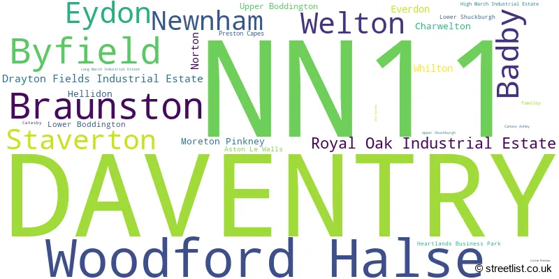
The largest settlement in the NN11 postal code is DAVENTRY followed by Woodford Halse, and Braunston.
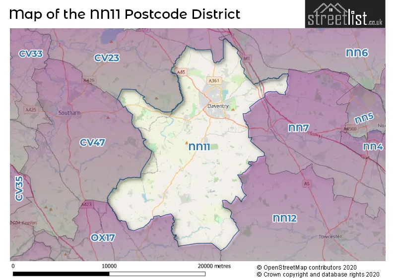
The NN11 Postcode shares a border with CV23 (RUGBY, Long Lawford, Houlton), CV47 (SOUTHAM, Bishops Itchington, Long Itchington), OX17 (Middleton Cheney, Adderbury, Kings Sutton), NN12 (TOWCESTER, Silverstone, Potterspury), NN6 (Earls Barton, Brixworth, Long Buckby) and NN7 (Weedon, Roade, Bugbrooke).
The primary settlement in the NN11 postcode district is Daventry, located in the county of Northamptonshire in England. Other significant settlements in the district include Norton, Welton, and Whilton.
For the district NN11, we have data on 9 postcode sectors. Here's a breakdown: The sector NN11 0, covers Daventry in Northamptonshire. The sector NN11 1 is non-geographic. It's often designated for PO Boxes, large organisations, or special services. The sector NN11 2, covers Daventry and Welton and Norton and Whilton in Northamptonshire. The sector NN11 3, covers Woodford Halse and Badby and Eydon in Northamptonshire. The sector NN11 4, covers Daventry in Northamptonshire. The sector NN11 6, covers Byfield and Staverton in Northamptonshire. The sector NN11 7, covers Braunston in Northamptonshire. The sector NN11 8, covers Daventry and Royal Oak Industrial Estate and Drayton Fields Industrial Estate in Northamptonshire. The sector NN11 9, covers Daventry in Northamptonshire.

Map of the NN11 Postcode District
Explore the NN11 postcode district by using our free interactive map.
When it comes to local government, postal geography often disregards political borders. However, for a breakdown in the NN11 District: the district mostly encompasses the West Northamptonshire (1144 postcodes), and finally, the Stratford-on-Avon District area (10 postcodes).
Recent House Sales in NN11
| Date | Price | Address |
|---|---|---|
| 12/10/2023 | £155,000 | Eden Close, Daventry, NN11 4QZ |
| 29/09/2023 | £412,500 | Lacemaker Crescent, Woodford Halse, Daventry, NN11 3UN |
| 29/09/2023 | £237,500 | The Firs, Daventry, NN11 0PX |
| 26/09/2023 | £116,000 | St Peters Close, Daventry, NN11 4SG |
| 20/09/2023 | £270,000 | Chiltern Road, Daventry, NN11 8SS |
| 19/09/2023 | £290,000 | Churchill Road, Welton, Daventry, NN11 2JH |
| 15/09/2023 | £195,000 | Mallard Drive, Woodford Halse, Daventry, NN11 3EJ |
| 15/09/2023 | £279,995 | Inlands Close, Daventry, NN11 4DG |
| 12/09/2023 | £460,000 | Countryside, Braunston, Daventry, NN11 7JU |
| 12/09/2023 | £123,000 | Frobisher Close, Daventry, NN11 4JL |
Weather Forecast for NN11
Press Button to Show Forecast for Badby Youth Hostel
| Time Period | Icon | Description | Temperature | Rain Probability | Wind |
|---|---|---|---|---|---|
| 00:00 to 03:00 | Clear night | 3.0°C (feels like 0.0°C) | 0.00% | N 7 mph | |
| 03:00 to 06:00 | Partly cloudy (night) | 2.0°C (feels like -1.0°C) | 1.00% | NNW 7 mph | |
| 06:00 to 09:00 | Partly cloudy (day) | 3.0°C (feels like 0.0°C) | 1.00% | NNW 7 mph | |
| 09:00 to 12:00 | Partly cloudy (day) | 7.0°C (feels like 4.0°C) | 0.00% | N 11 mph | |
| 12:00 to 15:00 | Cloudy | 9.0°C (feels like 7.0°C) | 7.00% | N 11 mph | |
| 15:00 to 18:00 | Cloudy | 10.0°C (feels like 8.0°C) | 5.00% | N 9 mph | |
| 18:00 to 21:00 | Cloudy | 9.0°C (feels like 7.0°C) | 5.00% | NNE 7 mph | |
| 21:00 to 00:00 | Overcast | 6.0°C (feels like 4.0°C) | 8.00% | ENE 4 mph |
Press Button to Show Forecast for Badby Youth Hostel
| Time Period | Icon | Description | Temperature | Rain Probability | Wind |
|---|---|---|---|---|---|
| 00:00 to 03:00 | Cloudy | 4.0°C (feels like 3.0°C) | 6.00% | NE 4 mph | |
| 03:00 to 06:00 | Overcast | 4.0°C (feels like 3.0°C) | 8.00% | N 4 mph | |
| 06:00 to 09:00 | Overcast | 5.0°C (feels like 2.0°C) | 9.00% | N 7 mph | |
| 09:00 to 12:00 | Overcast | 6.0°C (feels like 4.0°C) | 10.00% | NNE 9 mph | |
| 12:00 to 15:00 | Overcast | 8.0°C (feels like 6.0°C) | 9.00% | NNE 9 mph | |
| 15:00 to 18:00 | Overcast | 9.0°C (feels like 7.0°C) | 10.00% | NNE 9 mph | |
| 18:00 to 21:00 | Cloudy | 8.0°C (feels like 6.0°C) | 6.00% | NNE 9 mph | |
| 21:00 to 00:00 | Cloudy | 5.0°C (feels like 3.0°C) | 7.00% | NE 7 mph |
Press Button to Show Forecast for Badby Youth Hostel
| Time Period | Icon | Description | Temperature | Rain Probability | Wind |
|---|---|---|---|---|---|
| 00:00 to 03:00 | Partly cloudy (night) | 3.0°C (feels like 1.0°C) | 4.00% | NE 4 mph | |
| 03:00 to 06:00 | Cloudy | 2.0°C (feels like 1.0°C) | 7.00% | NNE 4 mph | |
| 06:00 to 09:00 | Overcast | 3.0°C (feels like 2.0°C) | 11.00% | N 4 mph | |
| 09:00 to 12:00 | Overcast | 6.0°C (feels like 5.0°C) | 13.00% | NNE 4 mph | |
| 12:00 to 15:00 | Light rain | 7.0°C (feels like 5.0°C) | 56.00% | NW 7 mph | |
| 15:00 to 18:00 | Light rain | 8.0°C (feels like 6.0°C) | 51.00% | NNW 7 mph | |
| 18:00 to 21:00 | Light rain | 7.0°C (feels like 5.0°C) | 48.00% | NNW 7 mph | |
| 21:00 to 00:00 | Cloudy | 6.0°C (feels like 4.0°C) | 19.00% | NNW 4 mph |
Press Button to Show Forecast for Badby Youth Hostel
| Time Period | Icon | Description | Temperature | Rain Probability | Wind |
|---|---|---|---|---|---|
| 00:00 to 03:00 | Cloudy | 5.0°C (feels like 3.0°C) | 9.00% | NE 4 mph | |
| 03:00 to 06:00 | Cloudy | 5.0°C (feels like 3.0°C) | 6.00% | NNE 4 mph | |
| 06:00 to 09:00 | Overcast | 5.0°C (feels like 3.0°C) | 10.00% | NNE 7 mph | |
| 09:00 to 12:00 | Overcast | 8.0°C (feels like 5.0°C) | 10.00% | NNW 9 mph | |
| 12:00 to 15:00 | Overcast | 10.0°C (feels like 8.0°C) | 10.00% | N 9 mph | |
| 15:00 to 18:00 | Cloudy | 10.0°C (feels like 8.0°C) | 12.00% | NNE 9 mph | |
| 18:00 to 21:00 | Cloudy | 10.0°C (feels like 8.0°C) | 6.00% | N 9 mph | |
| 21:00 to 00:00 | Partly cloudy (night) | 6.0°C (feels like 4.0°C) | 4.00% | NNE 7 mph |
Where is the NN11 Postcode District?
The NN11 postcode district is located in Daventry, a district town. It is nearby several other towns, including Southam to the west (8.34 miles away), Towcester to the southeast (10.07 miles away), Rugby to the north (11.80 miles away), Banbury to the southwest (12.23 miles away), Brackley to the south (12.65 miles away), and Northampton to the east (13.45 miles away). Additionally, the postcode district is approximately 67.16 miles away from the center of London.
The district is within the post town of DAVENTRY.
The sector has postcodes within the nation of England.
The NN11 Postcode District is covers the following regions.
- West Northamptonshire - Leicestershire, Rutland and Northamptonshire - East Midlands (England)
- Warwickshire - Herefordshire, Worcestershire and Warwickshire - West Midlands (England)
| Postcode Sector | Delivery Office |
|---|---|
| NN11 0 | Daventry Delivery Office |
| NN11 1 | Daventry Delivery Office |
| NN11 2 | Daventry Delivery Office |
| NN11 3 | Daventry Delivery Office |
| NN11 3 | Badby Scale Payment Delivery Office |
| NN11 3 | Charwelton Scale Payment Delivery Office |
| NN11 3 | Everdelivery Officen Scale Payment Delivery Office |
| NN11 3 | Newnham Scale Payment Delivery Office |
| NN11 3 | Woodford Halse Scale Payment Delivery Office |
| NN11 4 | Daventry Delivery Office |
| NN11 5 | Daventry Delivery Office |
| NN11 6 | Daventry Delivery Office |
| NN11 6 | Staverton Scale Payment Delivery Office |
| NN11 6 | Upper Boddington Scale Payment Delivery Office |
| NN11 7 | Daventry Delivery Office |
| NN11 7 | Braunston Scale Payment Delivery Office |
| NN11 8 | Daventry Delivery Office |
| NN11 9 | Daventry Delivery Office |
| N | N | 1 | 1 | - | X | X | X |
| N | N | 1 | 1 | Space | Numeric | Letter | Letter |
Tourist Attractions within the Postcode Area
We found 1 visitor attractions within the NN11 postcode area
| Canons Ashby House |
|---|
| Historic Properties |
| Historic Monument / Archaeological Site |
| View Canons Ashby House on Google Maps |
Current Monthly Rental Prices
| # Bedrooms | Min Price | Max Price | Avg Price |
|---|---|---|---|
| 1 | £635 | £695 | £668 |
| 2 | £775 | £1,150 | £869 |
| 3 | £850 | £1,550 | £1,275 |
| 4 | £940 | £3,200 | £1,665 |
| 5 | £2,250 | £2,250 | £2,250 |
| 6 | £1,800 | £1,800 | £1,800 |
| 7 | £5,500 | £5,500 | £5,500 |
Current House Prices
| # Bedrooms | Min Price | Max Price | Avg Price |
|---|---|---|---|
| £180,000 | £180,000 | £180,000 | |
| 1 | £90,000 | £280,000 | £138,632 |
| 2 | £106,000 | £360,000 | £229,000 |
| 3 | £189,950 | £700,000 | £324,314 |
| 4 | £240,000 | £1,150,000 | £450,259 |
| 5 | £340,000 | £2,400,000 | £881,848 |
| 6 | £500,000 | £2,000,000 | £960,833 |
| 7 | £1,950,000 | £1,950,000 | £1,950,000 |
| 8 | £1,950,000 | £1,950,000 | £1,950,000 |
| 14 | £1,750,000 | £1,750,000 | £1,750,000 |
Estate Agents who Operate in the NN11 District
| Logo | Name | Brand Name | Address | Contact Number | Total Properties |
|---|---|---|---|---|---|
 | Daventry | Laurence Tremayne Estate Agents | 10-12 Oxford Street, Daventry, NN11 4AD | 01327 221937 | 57 |
 | Daventry | Jackson Grundy Estate Agents | 53-55 High Street, Daventry, NN11 4BQ | 01327 223904 | 25 |
 | Daventry | Howkins & Harrison LLP | 27 Market Square Daventry NN11 4BH | 01327 228508 | 21 |
 | Daventry | Stonhills Estate Agents | 28 High Street Daventry NN11 4HU | 01327 223900 | 20 |
 | Northamptonshire | Campbells | 2 James Watt Close, Drayton Fields, Daventry, NN11 8RJ | 01327 221400 | 20 |
- Ashby St Ledgers
- Aston le Walls
- Badby
- Barby
- Braunston
- Byfield
- Charwelton
- Chipping Warden
- Culworth
- Daventry
- Everdon
- Eydon
- Hellidon
- Hinton
- Long Buckby Wharf
- Lower Boddington
- Lower Shuckburgh
- Maidford
- Moreton Pinkney
- Newnham
- Norton
- Preston Capes
- Priors Hardwick
- Priors Marston
- Staverton
- Upper Boddington
- Welton
- Whilton
- Woodford Halse
| Type of Property | 2018 Average | 2018 Sales | 2017 Average | 2017 Sales | 2016 Average | 2016 Sales | 2015 Average | 2015 Sales |
|---|---|---|---|---|---|---|---|---|
| Detached | £343,372 | 302 | £350,257 | 301 | £352,705 | 346 | £301,172 | 298 |
| Semi-Detached | £238,140 | 232 | £217,262 | 250 | £220,574 | 213 | £187,594 | 191 |
| Terraced | £182,169 | 199 | £181,833 | 194 | £170,467 | 213 | £153,634 | 221 |
| Flats | £117,983 | 46 | £121,928 | 60 | £113,524 | 47 | £110,103 | 50 |
Hotels within the Postcode Area
We found 15 hotels and guest houses within the NN11 postcode area
Hellidon Lakes Golf & Spa Hotel - QHotels
Hellidon, Daventry, lower-boddington, NN11 6GG.
View detailsAppletree House
appletree house appletree, Lower Boddington, lower-boddington, NN11 6UG.
View detailsThe Garden Room
Tudor Cottage, Upper Green, Moreton Pinkney Garden Room, Moreton Pinkney, moreton-pinkney, NN11 3SG.
View detailsApple Cottage Bed and Breakfast
Apple Cottage, Banbury Road, Lower Boddington, lower-boddington, NN11 6XY.
View detailsThe Plough at Boddington
32 Warwick Road, Upper Boddington, upper-boddington, NN11 6DH.
View detailsThe Clock Tower
The Clock Tower, Lower Catesby, Northants, Daventry, daventry, NN11 6LF.
View details