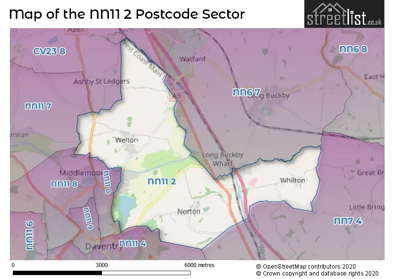
The NN11 2 postcode sector is within the county of Northamptonshire.
Did you know? According to the 2021 Census, the NN11 2 postcode sector is home to a bustling 2,972 residents!
Given that each sector allows for 400 unique postcode combinations. Letters C, I, K, M, O and V are not allowed in the last two letters of a postcode. With 95 postcodes already in use, this leaves 305 units available.
The largest settlement in the NN11 2 postal code is DAVENTRY followed by Welton, and Whilton.
The NN11 2 Postcode shares a border with NN11 4 (DAVENTRY, High March Industrial Estate), NN6 7 (Long Buckby, Crick, West Haddon), NN7 4 (Weedon, Harpole, Kislingbury), NN11 0 (DAVENTRY), NN11 7 (Braunston), NN11 8 (DAVENTRY, Royal Oak Industrial Estate, Drayton Fields Industrial Estate) and CV23 8 (Kilsby, Barby, Willoughby).
The sector is within the post town of DAVENTRY.
NN11 2 is a postcode sector within the NN11 postcode district which is within the NN Northampton postcode area.
The Royal Mail delivery office for the NN11 2 postal sector is the Daventry Delivery Office.
The area of the NN11 2 postcode sector is 9.16 square miles which is 23.72 square kilometres or 5,861.60 square acres.
The NN11 2 postcode sector is crossed by the M1 motorway.
The NN11 2 postcode sector is crossed by the A5 Major A road.
Waterways within the NN11 2 postcode sector include the Grand Union Canal, Braunston Tunnel.

Map of the NN11 2 Postcode Sector
Explore the NN11 2 postcode sector by using our free interactive map.
| N | N | 1 | 1 | - | 2 | X | X |
| N | N | 1 | 1 | Space | 2 | Letter | Letter |
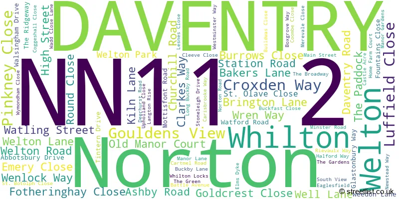
Official List of Streets
DAVENTRY (45 Streets)
Welton (17 Streets)
Norton (9 Streets)
Unofficial Streets or Alternative Spellings
Weather Forecast for NN11 2
Press Button to Show Forecast for Watford (Northamptonshire)
| Time Period | Icon | Description | Temperature | Rain Probability | Wind |
|---|---|---|---|---|---|
| 15:00 to 18:00 | Cloudy | 10.0°C (feels like 7.0°C) | 4.00% | NNW 9 mph | |
| 18:00 to 21:00 | Cloudy | 8.0°C (feels like 7.0°C) | 4.00% | N 4 mph | |
| 21:00 to 00:00 | Cloudy | 6.0°C (feels like 5.0°C) | 5.00% | SE 4 mph |
Press Button to Show Forecast for Watford (Northamptonshire)
| Time Period | Icon | Description | Temperature | Rain Probability | Wind |
|---|---|---|---|---|---|
| 00:00 to 03:00 | Cloudy | 3.0°C (feels like 1.0°C) | 4.00% | SSW 4 mph | |
| 03:00 to 06:00 | Cloudy | 3.0°C (feels like 1.0°C) | 4.00% | W 4 mph | |
| 06:00 to 09:00 | Cloudy | 4.0°C (feels like 1.0°C) | 6.00% | W 7 mph | |
| 09:00 to 12:00 | Cloudy | 6.0°C (feels like 4.0°C) | 16.00% | W 9 mph | |
| 12:00 to 15:00 | Light rain | 8.0°C (feels like 6.0°C) | 50.00% | WNW 9 mph | |
| 15:00 to 18:00 | Light rain | 8.0°C (feels like 5.0°C) | 73.00% | N 9 mph | |
| 18:00 to 21:00 | Cloudy | 7.0°C (feels like 5.0°C) | 8.00% | ENE 4 mph | |
| 21:00 to 00:00 | Cloudy | 5.0°C (feels like 3.0°C) | 5.00% | E 4 mph |
Press Button to Show Forecast for Watford (Northamptonshire)
| Time Period | Icon | Description | Temperature | Rain Probability | Wind |
|---|---|---|---|---|---|
| 00:00 to 03:00 | Partly cloudy (night) | 3.0°C (feels like 1.0°C) | 1.00% | ENE 4 mph | |
| 03:00 to 06:00 | Clear night | 1.0°C (feels like -1.0°C) | 1.00% | ENE 4 mph | |
| 06:00 to 09:00 | Sunny day | 2.0°C (feels like 0.0°C) | 1.00% | NE 4 mph | |
| 09:00 to 12:00 | Sunny day | 7.0°C (feels like 4.0°C) | 2.00% | ENE 7 mph | |
| 12:00 to 15:00 | Overcast | 9.0°C (feels like 8.0°C) | 10.00% | ENE 4 mph | |
| 15:00 to 18:00 | Cloudy | 9.0°C (feels like 9.0°C) | 9.00% | NE 4 mph | |
| 18:00 to 21:00 | Cloudy | 8.0°C (feels like 6.0°C) | 8.00% | ENE 7 mph | |
| 21:00 to 00:00 | Cloudy | 5.0°C (feels like 2.0°C) | 8.00% | ENE 7 mph |
Press Button to Show Forecast for Watford (Northamptonshire)
| Time Period | Icon | Description | Temperature | Rain Probability | Wind |
|---|---|---|---|---|---|
| 00:00 to 03:00 | Cloudy | 3.0°C (feels like 1.0°C) | 10.00% | ENE 7 mph | |
| 03:00 to 06:00 | Cloudy | 3.0°C (feels like 0.0°C) | 12.00% | ENE 7 mph | |
| 06:00 to 09:00 | Cloudy | 4.0°C (feels like 1.0°C) | 15.00% | ENE 7 mph | |
| 09:00 to 12:00 | Cloudy | 7.0°C (feels like 5.0°C) | 17.00% | ENE 9 mph | |
| 12:00 to 15:00 | Overcast | 10.0°C (feels like 7.0°C) | 23.00% | ENE 9 mph | |
| 15:00 to 18:00 | Cloudy | 10.0°C (feels like 8.0°C) | 17.00% | ENE 11 mph | |
| 18:00 to 21:00 | Cloudy | 9.0°C (feels like 6.0°C) | 18.00% | NE 11 mph | |
| 21:00 to 00:00 | Light rain | 7.0°C (feels like 4.0°C) | 52.00% | NE 11 mph |
Press Button to Show Forecast for Watford (Northamptonshire)
| Time Period | Icon | Description | Temperature | Rain Probability | Wind |
|---|---|---|---|---|---|
| 00:00 to 03:00 | Light rain | 7.0°C (feels like 3.0°C) | 51.00% | NE 11 mph | |
| 03:00 to 06:00 | Heavy rain | 7.0°C (feels like 3.0°C) | 76.00% | NE 11 mph | |
| 06:00 to 09:00 | Heavy rain | 7.0°C (feels like 5.0°C) | 80.00% | NE 7 mph | |
| 09:00 to 12:00 | Light rain | 9.0°C (feels like 7.0°C) | 51.00% | ESE 9 mph | |
| 12:00 to 15:00 | Light rain shower (day) | 11.0°C (feels like 9.0°C) | 42.00% | SSE 9 mph | |
| 15:00 to 18:00 | Heavy rain shower (day) | 11.0°C (feels like 8.0°C) | 59.00% | NE 11 mph | |
| 18:00 to 21:00 | Light rain shower (day) | 9.0°C (feels like 7.0°C) | 37.00% | NNE 9 mph | |
| 21:00 to 00:00 | Partly cloudy (night) | 7.0°C (feels like 5.0°C) | 8.00% | NW 7 mph |
Schools and Places of Education Within the NN11 2 Postcode Sector
Monksmoor Park Church of England Primary School
Voluntary aided school
Croxden Way, Daventry, Northamptonshire, NN11 2PD
Head: Mrs Katie Towers
Ofsted Rating: Good
Inspection: 2023-03-29 (392 days ago)
Website: Visit Monksmoor Park Church of England Primary School Website
Phone: 01327493112
Number of Pupils: 175
Welton Church of England Academy
Academy converter
Well Lane, Daventry, Northamptonshire, NN11 2JZ
Head: Mr Sol Johnson
Ofsted Rating: Outstanding
Inspection: 2022-05-26 (699 days ago)
Website: Visit Welton Church of England Academy Website
Phone: 01327703177
Number of Pupils: 130
House Prices in the NN11 2 Postcode Sector
| Type of Property | 2018 Average | 2018 Sales | 2017 Average | 2017 Sales | 2016 Average | 2016 Sales | 2015 Average | 2015 Sales |
|---|---|---|---|---|---|---|---|---|
| Detached | £379,783 | 55 | £370,663 | 67 | £374,760 | 70 | £350,235 | 41 |
| Semi-Detached | £266,340 | 54 | £255,602 | 63 | £239,941 | 57 | £214,924 | 27 |
| Terraced | £206,500 | 6 | £248,478 | 14 | £233,950 | 7 | £219,320 | 10 |
| Flats | £169,550 | 5 | £157,379 | 7 | £196,633 | 3 | £138,611 | 4 |
Important Postcodes NN11 2 in the Postcode Sector
NN11 2JZ is the postcode for Welton C of E Primary School, Well Lane
| The NN11 2 Sector is within these Local Authorities |
|
|---|---|
| The NN11 2 Sector is within these Counties |
|
| The NN11 2 Sector is within these Water Company Areas |
|