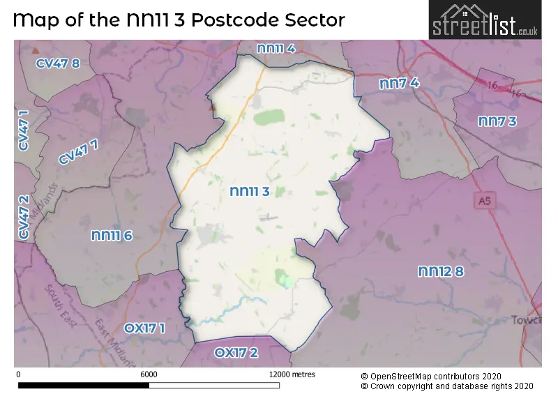
The NN11 3 postcode sector is within the county of Northamptonshire.
Did you know? According to the 2021 Census, the NN11 3 postcode sector is home to a bustling 7,175 residents!
Given that each sector allows for 400 unique postcode combinations. Letters C, I, K, M, O and V are not allowed in the last two letters of a postcode. With 242 postcodes already in use, this leaves 158 units available.
The largest settlement in the NN11 3 postal code is Woodford Halse followed by Eydon, and Badby.
The NN11 3 Postcode shares a border with NN11 4 (DAVENTRY, High March Industrial Estate), NN7 4 (Weedon, Harpole, Kislingbury), NN11 6 (Byfield, Staverton, Upper Boddington), NN12 8 (Silverstone, Greens Norton, Pattishall), OX17 1 (Cropredy, Chipping Warden, Mollington) and OX17 2 (Middleton Cheney, Greatworth, Chacombe).
The sector is within the post town of DAVENTRY.
NN11 3 is a postcode sector within the NN11 postcode district which is within the NN Northampton postcode area.
The Royal Mail delivery office for the NN11 3 postal sector is the Daventry Delivery Office and Badby Scale Payment Delivery Office and Charwelton Scale Payment Delivery Office and Everdelivery Officen Scale Payment Delivery Office and Newnham Scale Payment Delivery Office and Woodford Halse Scale Payment Delivery Office.
The area of the NN11 3 postcode sector is 33.89 square miles which is 87.78 square kilometres or 21,691.49 square acres.

Map of the NN11 3 Postcode Sector
Explore the NN11 3 postcode sector by using our free interactive map.
| N | N | 1 | 1 | - | 3 | X | X |
| N | N | 1 | 1 | Space | 3 | Letter | Letter |
Official List of Streets
Woodford Halse (87 Streets)
Newnham (18 Streets)
Charwelton (9 Streets)
Moreton Pinkney (10 Streets)
Eydon (19 Streets)
Everdon (9 Streets)
Badby (20 Streets)
Byfield (2 Streets)
Preston Capes (5 Streets)
Canons Ashby (1 Streets)
Fawsley (1 Streets)
DAVENTRY (1 Streets)
Unofficial Streets or Alternative Spellings
Weedon
FARTHINGSTONE ROAD BANBURY LANE CHAPEL STREET EF1 EF6 EYDON LANE LEAFLETED WALK LOCKE ROW MAPEL CLOSE MORTON ROAD MOUNT PLEASENT OXFORD LANE PACKHORSE BRIDGE PATH TO NATURE RESERVE STATION COURT THE BEAVER CENTRE THE RAMBLE VICARAGE GREENBadby
COURT YARD LANEStaverton
BADBY LANEDAVENTRY
BADBY ROAD WESTWeather Forecast for NN11 3
Press Button to Show Forecast for Canons Ashby House
| Time Period | Icon | Description | Temperature | Rain Probability | Wind |
|---|---|---|---|---|---|
| 18:00 to 21:00 | Cloudy | 8.0°C (feels like 7.0°C) | 4.00% | NNW 4 mph | |
| 21:00 to 00:00 | Cloudy | 6.0°C (feels like 5.0°C) | 4.00% | SSE 2 mph |
Press Button to Show Forecast for Canons Ashby House
| Time Period | Icon | Description | Temperature | Rain Probability | Wind |
|---|---|---|---|---|---|
| 00:00 to 03:00 | Cloudy | 4.0°C (feels like 2.0°C) | 4.00% | SSW 4 mph | |
| 03:00 to 06:00 | Cloudy | 3.0°C (feels like 1.0°C) | 4.00% | W 4 mph | |
| 06:00 to 09:00 | Cloudy | 3.0°C (feels like 1.0°C) | 5.00% | W 7 mph | |
| 09:00 to 12:00 | Cloudy | 6.0°C (feels like 3.0°C) | 48.00% | W 9 mph | |
| 12:00 to 15:00 | Light rain shower (day) | 9.0°C (feels like 6.0°C) | 38.00% | NW 11 mph | |
| 15:00 to 18:00 | Cloudy | 8.0°C (feels like 5.0°C) | 32.00% | N 9 mph | |
| 18:00 to 21:00 | Cloudy | 7.0°C (feels like 5.0°C) | 6.00% | ENE 7 mph | |
| 21:00 to 00:00 | Cloudy | 5.0°C (feels like 3.0°C) | 4.00% | E 4 mph |
Press Button to Show Forecast for Canons Ashby House
| Time Period | Icon | Description | Temperature | Rain Probability | Wind |
|---|---|---|---|---|---|
| 00:00 to 03:00 | Cloudy | 3.0°C (feels like 1.0°C) | 3.00% | ENE 4 mph | |
| 03:00 to 06:00 | Partly cloudy (night) | 2.0°C (feels like 0.0°C) | 2.00% | ENE 4 mph | |
| 06:00 to 09:00 | Cloudy | 2.0°C (feels like 0.0°C) | 4.00% | NE 7 mph | |
| 09:00 to 12:00 | Sunny day | 6.0°C (feels like 4.0°C) | 2.00% | ENE 7 mph | |
| 12:00 to 15:00 | Cloudy | 9.0°C (feels like 7.0°C) | 9.00% | ENE 4 mph | |
| 15:00 to 18:00 | Overcast | 9.0°C (feels like 8.0°C) | 10.00% | NE 4 mph | |
| 18:00 to 21:00 | Cloudy | 8.0°C (feels like 7.0°C) | 9.00% | NE 4 mph | |
| 21:00 to 00:00 | Cloudy | 5.0°C (feels like 2.0°C) | 11.00% | ENE 7 mph |
Press Button to Show Forecast for Canons Ashby House
| Time Period | Icon | Description | Temperature | Rain Probability | Wind |
|---|---|---|---|---|---|
| 00:00 to 03:00 | Cloudy | 3.0°C (feels like 1.0°C) | 12.00% | ENE 7 mph | |
| 03:00 to 06:00 | Cloudy | 2.0°C (feels like 0.0°C) | 14.00% | ENE 7 mph | |
| 06:00 to 09:00 | Cloudy | 4.0°C (feels like 0.0°C) | 14.00% | ENE 7 mph | |
| 09:00 to 12:00 | Cloudy | 7.0°C (feels like 4.0°C) | 18.00% | ENE 9 mph | |
| 12:00 to 15:00 | Overcast | 9.0°C (feels like 6.0°C) | 22.00% | ENE 9 mph | |
| 15:00 to 18:00 | Overcast | 10.0°C (feels like 8.0°C) | 20.00% | ENE 11 mph | |
| 18:00 to 21:00 | Cloudy | 9.0°C (feels like 6.0°C) | 22.00% | ENE 11 mph | |
| 21:00 to 00:00 | Light rain | 7.0°C (feels like 3.0°C) | 53.00% | NE 11 mph |
Press Button to Show Forecast for Canons Ashby House
| Time Period | Icon | Description | Temperature | Rain Probability | Wind |
|---|---|---|---|---|---|
| 00:00 to 03:00 | Light rain | 6.0°C (feels like 3.0°C) | 52.00% | NE 11 mph | |
| 03:00 to 06:00 | Heavy rain | 6.0°C (feels like 3.0°C) | 76.00% | NE 11 mph | |
| 06:00 to 09:00 | Heavy rain | 7.0°C (feels like 4.0°C) | 78.00% | NE 9 mph | |
| 09:00 to 12:00 | Light rain | 9.0°C (feels like 7.0°C) | 53.00% | ESE 9 mph | |
| 12:00 to 15:00 | Light rain | 10.0°C (feels like 8.0°C) | 54.00% | WSW 9 mph | |
| 15:00 to 18:00 | Heavy rain shower (day) | 10.0°C (feels like 7.0°C) | 60.00% | SW 11 mph | |
| 18:00 to 21:00 | Light rain shower (day) | 9.0°C (feels like 7.0°C) | 37.00% | SW 9 mph | |
| 21:00 to 00:00 | Cloudy | 7.0°C (feels like 5.0°C) | 9.00% | SW 7 mph |
Schools and Places of Education Within the NN11 3 Postcode Sector
Badby School
Academy converter
School Lane, Badby, Northamptonshire, NN11 3AJ
Head: Mr Ben Edge
Ofsted Rating: Good
Inspection: 2023-06-21 (308 days ago)
Website: Visit Badby School Website
Phone: 01327871363
Number of Pupils: 157
Newnham Primary School
Academy converter
School Hill, Daventry, Northamptonshire, NN11 3HG
Head: Mr Solomon Johnson
Ofsted Rating: Good
Inspection: 2023-03-02 (419 days ago)
Website: Visit Newnham Primary School Website
Phone: 01327705053
Number of Pupils: 74
Woodford Halse Church of England Primary Academy
Academy converter
High Street, Daventry, Northamptonshire, NN11 3RQ
Head: Miss Alison Crockford
Ofsted Rating: Good
Inspection: 2019-11-13 (1624 days ago)
Website: Visit Woodford Halse Church of England Primary Academy Website
Phone: 01327265900
Number of Pupils: 269
House Prices in the NN11 3 Postcode Sector
| Type of Property | 2018 Average | 2018 Sales | 2017 Average | 2017 Sales | 2016 Average | 2016 Sales | 2015 Average | 2015 Sales |
|---|---|---|---|---|---|---|---|---|
| Detached | £355,396 | 58 | £431,436 | 57 | £399,420 | 74 | £362,424 | 51 |
| Semi-Detached | £252,505 | 55 | £227,693 | 43 | £256,524 | 39 | £205,280 | 38 |
| Terraced | £213,676 | 25 | £236,232 | 25 | £196,095 | 41 | £191,575 | 39 |
| Flats | £97,000 | 2 | £87,925 | 4 | £90,333 | 3 | £165,000 | 1 |
Important Postcodes NN11 3 in the Postcode Sector
NN11 3AJ is the postcode for Badby Primary School, School Lane
NN11 3BL is the postcode for Everdon Outdoor Learning Centre, The Old School
NN11 3HG is the postcode for Newnham Primary School, School Hill
NN11 3RQ is the postcode for Woodford Halse C of E Primary School, High Street, Woodford Halse, Woodford Halse C of E Primary School, High Street, NURSERY BLOCK B, Woodford Halse C of E Primary School, High Street, and NEW HALL BLOCK H, Woodford Halse C of E Primary School, High Street
| The NN11 3 Sector is within these Local Authorities |
|
|---|---|
| The NN11 3 Sector is within these Counties |
|
| The NN11 3 Sector is within these Water Company Areas |
|
Tourist Attractions within the NN11 3 Postcode Area
We found 1 visitor attractions within the NN11 postcode area
| Canons Ashby House |
|---|
| Historic Properties |
| Historic Monument / Archaeological Site |
| View Canons Ashby House on Google Maps |