The NN14 postcode district is a postal district located in the NN Northampton postcode area with a population of 46,878 residents according to the 2021 England and Wales Census.
The area of the NN14 postcode district is 102.12 square miles which is 264.49 square kilometres or 65,356.25 acres.
Currently, the NN14 district has about 1150 postcode units spread across 5 geographic postcode sectors.
Given that each sector allows for 400 unique postcode combinations, the district has a capacity of 2,000 postcodes. With 1150 postcodes already in use, this leaves 850 units available.
The largest settlement in the NN14 postal code is Desborough followed by Rothwell, and Thrapston.
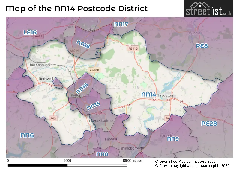
The NN14 Postcode shares a border with PE28 (Brampton, Sawtry, Warboys), LE16 (MARKET HARBOROUGH, Great Bowden, Lubenham), PE8 (Oundle, Wittering, Kings Cliffe), NN15 (KETTERING, Burton Latimer, Barton Seagrave), NN16 (KETTERING, Telford Way Industrial Estate), NN17 (CORBY, Weldon, Gretton), NN18 (CORBY, Great Oakley), NN6 (Earls Barton, Brixworth, Long Buckby) and NN9 (Raunds, Irthlingborough, Finedon).
In the NN14 postcode district, the primary settlement is Kettering, which is located in the county of Northamptonshire in England. Other significant settlements in the same postcode district include Desborough, Aldwincle, Brigstock, and Rothwell. The most significant post town in the NN14 postcode district is Kettering.
For the district NN14, we have data on 5 postcode sectors. Here's a breakdown: The sector NN14 1, covers Mawsley and Broughton and Geddington in Northamptonshire. The sector NN14 2, covers Desborough in Northamptonshire. The sector NN14 3, covers Brigstock and Islip and Titchmarsh in Northamptonshire. The sector NN14 4, covers Thrapston and Ringstead and Woodford in Northamptonshire. The sector NN14 6, covers Rothwell in Northamptonshire.

Map of the NN14 Postcode District
Explore the NN14 postcode district by using our free interactive map.
When it comes to local government, postal geography often disregards political borders. However, for a breakdown in the NN14 District: the district mostly encompasses the North Northamptonshire area with a total of 1170 postcodes.
Recent House Sales in NN14
| Date | Price | Address |
|---|---|---|
| 23/10/2023 | £365,000 | Bonsor Gardens, Ringstead, Kettering, NN14 4QW |
| 12/10/2023 | £245,000 | Main Street, Sudborough, Kettering, NN14 3BX |
| 06/10/2023 | £275,000 | Norlinton Close, Orlingbury, Kettering, NN14 1FD |
| 28/09/2023 | £275,000 | Doulton Close, Desborough, Kettering, NN14 2XX |
| 22/09/2023 | £274,000 | St Clair Rise, Thrapston, Kettering, NN14 4FU |
| 22/09/2023 | £320,000 | Carlow Road, Ringstead, Kettering, NN14 4DW |
| 22/09/2023 | £300,000 | Unity Street, Desborough, Kettering, NN14 2NY |
| 20/09/2023 | £302,500 | Cannock Crescent, Desborough, Kettering, NN14 2WG |
| 19/09/2023 | £225,000 | Midland Road, Thrapston, Kettering, NN14 4JR |
| 15/09/2023 | £68,748 | Greening Road, Rothwell, Kettering, NN14 6JA |
Weather Forecast for NN14
Press Button to Show Forecast for Boughton House
| Time Period | Icon | Description | Temperature | Rain Probability | Wind |
|---|---|---|---|---|---|
| 18:00 to 21:00 | Partly cloudy (day) | 7.0°C (feels like 6.0°C) | 7.00% | NNE 4 mph | |
| 21:00 to 00:00 | Cloudy | 5.0°C (feels like 4.0°C) | 5.00% | ESE 2 mph |
Press Button to Show Forecast for Boughton House
| Time Period | Icon | Description | Temperature | Rain Probability | Wind |
|---|---|---|---|---|---|
| 00:00 to 03:00 | Cloudy | 4.0°C (feels like 2.0°C) | 4.00% | S 4 mph | |
| 03:00 to 06:00 | Cloudy | 4.0°C (feels like 2.0°C) | 4.00% | WSW 7 mph | |
| 06:00 to 09:00 | Cloudy | 4.0°C (feels like 1.0°C) | 5.00% | W 7 mph | |
| 09:00 to 12:00 | Cloudy | 7.0°C (feels like 4.0°C) | 14.00% | WNW 11 mph | |
| 12:00 to 15:00 | Light rain shower (day) | 9.0°C (feels like 6.0°C) | 35.00% | NW 11 mph | |
| 15:00 to 18:00 | Cloudy | 7.0°C (feels like 5.0°C) | 16.00% | NNE 7 mph | |
| 18:00 to 21:00 | Cloudy | 7.0°C (feels like 6.0°C) | 8.00% | E 4 mph | |
| 21:00 to 00:00 | Partly cloudy (night) | 4.0°C (feels like 2.0°C) | 2.00% | ENE 4 mph |
Press Button to Show Forecast for Boughton House
| Time Period | Icon | Description | Temperature | Rain Probability | Wind |
|---|---|---|---|---|---|
| 00:00 to 03:00 | Clear night | 1.0°C (feels like -1.0°C) | 2.00% | NE 4 mph | |
| 03:00 to 06:00 | Clear night | 0.0°C (feels like -2.0°C) | 1.00% | NNE 4 mph | |
| 06:00 to 09:00 | Sunny day | 2.0°C (feels like 0.0°C) | 1.00% | NNE 4 mph | |
| 09:00 to 12:00 | Sunny day | 7.0°C (feels like 5.0°C) | 2.00% | ENE 7 mph | |
| 12:00 to 15:00 | Cloudy | 9.0°C (feels like 8.0°C) | 9.00% | ENE 4 mph | |
| 15:00 to 18:00 | Cloudy | 9.0°C (feels like 8.0°C) | 8.00% | ENE 4 mph | |
| 18:00 to 21:00 | Cloudy | 8.0°C (feels like 6.0°C) | 8.00% | ENE 7 mph | |
| 21:00 to 00:00 | Cloudy | 5.0°C (feels like 3.0°C) | 9.00% | ENE 7 mph |
Press Button to Show Forecast for Boughton House
| Time Period | Icon | Description | Temperature | Rain Probability | Wind |
|---|---|---|---|---|---|
| 00:00 to 03:00 | Cloudy | 4.0°C (feels like 2.0°C) | 10.00% | ENE 4 mph | |
| 03:00 to 06:00 | Cloudy | 3.0°C (feels like 1.0°C) | 11.00% | ENE 4 mph | |
| 06:00 to 09:00 | Cloudy | 4.0°C (feels like 2.0°C) | 14.00% | ENE 7 mph | |
| 09:00 to 12:00 | Cloudy | 8.0°C (feels like 5.0°C) | 16.00% | ENE 9 mph | |
| 12:00 to 15:00 | Overcast | 10.0°C (feels like 8.0°C) | 23.00% | ENE 11 mph | |
| 15:00 to 18:00 | Overcast | 10.0°C (feels like 8.0°C) | 21.00% | ENE 11 mph | |
| 18:00 to 21:00 | Cloudy | 9.0°C (feels like 6.0°C) | 19.00% | NE 11 mph | |
| 21:00 to 00:00 | Light rain | 7.0°C (feels like 4.0°C) | 53.00% | NE 11 mph |
Press Button to Show Forecast for Boughton House
| Time Period | Icon | Description | Temperature | Rain Probability | Wind |
|---|---|---|---|---|---|
| 00:00 to 03:00 | Light rain | 7.0°C (feels like 4.0°C) | 51.00% | NE 11 mph | |
| 03:00 to 06:00 | Heavy rain | 7.0°C (feels like 4.0°C) | 77.00% | NE 13 mph | |
| 06:00 to 09:00 | Heavy rain | 8.0°C (feels like 5.0°C) | 78.00% | ENE 11 mph | |
| 09:00 to 12:00 | Light rain shower (day) | 10.0°C (feels like 8.0°C) | 40.00% | ESE 11 mph | |
| 12:00 to 15:00 | Light rain shower (day) | 12.0°C (feels like 10.0°C) | 43.00% | SSE 9 mph | |
| 15:00 to 18:00 | Heavy rain shower (day) | 11.0°C (feels like 8.0°C) | 59.00% | SW 11 mph | |
| 18:00 to 21:00 | Light rain shower (day) | 10.0°C (feels like 7.0°C) | 36.00% | NNE 11 mph | |
| 21:00 to 00:00 | Cloudy | 8.0°C (feels like 6.0°C) | 7.00% | SSW 7 mph |
Where is the NN14 Postcode District?
The postcode district NN14 is located in the town of Kettering. It is situated near several towns: Corby to the north, Wellingborough to the south, Market Harborough to the northwest, Northampton to the southwest, and Peterborough to the northeast. Furthermore, NN14 is approximately 66.37 miles away from the center of London.
The district is within the post town of KETTERING.
The sector has postcodes within the nation of England.
The NN14 Postcode District is in the North Northamptonshire region of Leicestershire, Rutland and Northamptonshire within the East Midlands (England).
| Postcode Sector | Delivery Office |
|---|---|
| NN14 1 | Kettering Delivery Office |
| NN14 2 | Kettering Delivery Office |
| NN14 3 | Kettering Delivery Office |
| NN14 4 | Kettering Delivery Office |
| NN14 6 | Kettering Delivery Office |
| N | N | 1 | 4 | - | X | X | X |
| N | N | 1 | 4 | Space | Numeric | Letter | Letter |
Tourist Attractions within the Postcode Area
We found 1 visitor attractions within the NN14 postcode area
| Rushton Triangular Lodge |
|---|
| Historic Properties |
| Historic House / House and Garden / Palace |
| View Rushton Triangular Lodge on Google Maps |
Current Monthly Rental Prices
| # Bedrooms | Min Price | Max Price | Avg Price |
|---|---|---|---|
| £220 | £220 | £220 | |
| 1 | £600 | £825 | £665 |
| 2 | £750 | £900 | £804 |
| 3 | £925 | £2,300 | £1,235 |
| 4 | £1,275 | £2,200 | £1,623 |
| 5 | £2,000 | £2,900 | £2,520 |
Current House Prices
| # Bedrooms | Min Price | Max Price | Avg Price |
|---|---|---|---|
| £60,000 | £4,600,000 | £1,176,000 | |
| 1 | £60,000 | £295,000 | £151,244 |
| 2 | £79,000 | £465,000 | £230,919 |
| 3 | £170,000 | £725,000 | £320,007 |
| 4 | £260,000 | £1,125,000 | £489,949 |
| 5 | £325,000 | £2,000,000 | £680,652 |
| 6 | £475,000 | £950,000 | £695,625 |
| 7 | £799,995 | £799,995 | £799,995 |
| 9 | £2,850,000 | £2,850,000 | £2,850,000 |
Estate Agents who Operate in the NN14 District
| Logo | Name | Brand Name | Address | Contact Number | Total Properties |
|---|---|---|---|---|---|
 | Kettering | Henderson Connellan | 15-16 Market Place, Kettering, NN16 0AJ | 01536 907610 | 44 |
 | Thrapston | Simpson & Partners | 43-45 High Street, Thrapston, NN14 4JJ | 01832 770614 | 37 |
 | Thrapston | Sharman Quinney | 16 High Street, Thrapston, NN14 4JH | 01832 773674 | 28 |
 | Rothwell | Simon & Co | 23 High Street, Rothwell, NN14 6AD | 01536 418100 | 24 |
 | Desborough | Pattison Lane | 42 Station Road, Desborough, Kettering, Northamptonshire, NN14 2RL | 01536 907991 | 21 |
- Aldwincle
- Brigstock
- Broughton
- Clopton
- Corby
- Cranford St Andrew
- Cranford St John
- Denford
- Desborough
- Geddington
- Great Addington
- Great Cransley
- Harrington
- Isham
- Islip
- Kettering
- Little Addington
- Loddington
- Lowick
- Mawsley Village
- Orlingbury
- Orton
- Pytchley
- Ringstead
- Rothwell
- Rushton
- Slipton
- Stanion
- Sudborough
- Thorpe Malsor
- Thrapston
- Titchmarsh
- Twywell
- Upper Benefield
- Wilbarston
- Woodford
| Type of Property | 2018 Average | 2018 Sales | 2017 Average | 2017 Sales | 2016 Average | 2016 Sales | 2015 Average | 2015 Sales |
|---|---|---|---|---|---|---|---|---|
| Detached | £341,709 | 345 | £324,326 | 430 | £303,637 | 489 | £283,019 | 402 |
| Semi-Detached | £210,165 | 251 | £206,484 | 275 | £183,067 | 287 | £173,442 | 257 |
| Terraced | £174,081 | 232 | £161,823 | 259 | £161,536 | 305 | £142,839 | 268 |
| Flats | £126,141 | 39 | £121,626 | 46 | £116,107 | 66 | £100,091 | 40 |