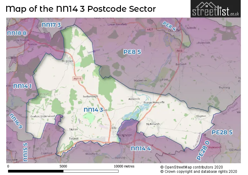
The NN14 3 postcode sector stands on the Northamptonshire and Cambridgeshire border.
Did you know? According to the 2021 Census, the NN14 3 postcode sector is home to a bustling 4,209 residents!
Given that each sector allows for 400 unique postcode combinations. Letters C, I, K, M, O and V are not allowed in the last two letters of a postcode. With 144 postcodes already in use, this leaves 256 units available.
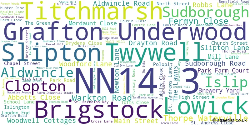
The largest settlement in the NN14 3 postal code is Brigstock followed by Islip, and Titchmarsh.
The NN14 3 Postcode shares a border with NN15 5 (Burton Latimer, KETTERING, Barton Seagrave), PE28 0 (Kimbolton, Perry, Ellington), PE28 5 (Sawtry, Glatton, Woodwalton), NN14 4 (Thrapston, Ringstead, Woodford), NN16 9 (KETTERING, Warkton, Weekley), NN17 3 (Weldon, Gretton, Harringworth), NN14 1 (Broughton, Mawsley, Geddington) and PE8 5 (Barnwell, Oundle, Polebrook).
The sector is within the post town of KETTERING.
NN14 3 is a postcode sector within the NN14 postcode district which is within the NN Northampton postcode area.
The Royal Mail delivery office for the NN14 3 postal sector is the Kettering Delivery Office.
The area of the NN14 3 postcode sector is 35.59 square miles which is 92.18 square kilometres or 22,777.59 square acres.
The NN14 3 postcode sector is crossed by the A14 Major A road.
Waterways within the NN14 3 postcode sector include the River Nene.

Map of the NN14 3 Postcode Sector
Explore the NN14 3 postcode sector by using our free interactive map.
| N | N | 1 | 4 | - | 3 | X | X |
| N | N | 1 | 4 | Space | 3 | Letter | Letter |
Official List of Streets
Titchmarsh (17 Streets)
Islip (23 Streets)
Lowick (7 Streets)
Brigstock (34 Streets)
Aldwincle (9 Streets)
Clopton (2 Streets)
Sudborough (5 Streets)
Thorpe Waterville (1 Streets)
Slipton (3 Streets)
Twywell (2 Streets)
Grafton Underwood (1 Streets)
Unofficial Streets or Alternative Spellings
Bythorn
WARREN LANEWeldon
BEARS LANEGeddington
GRAFTON ROADWeather Forecast for NN14 3
Press Button to Show Forecast for Boughton House
| Time Period | Icon | Description | Temperature | Rain Probability | Wind |
|---|---|---|---|---|---|
| 12:00 to 15:00 | Light rain shower (day) | 9.0°C (feels like 6.0°C) | 35.00% | NW 11 mph | |
| 15:00 to 18:00 | Cloudy | 7.0°C (feels like 5.0°C) | 16.00% | NNE 7 mph | |
| 18:00 to 21:00 | Cloudy | 7.0°C (feels like 6.0°C) | 8.00% | E 4 mph | |
| 21:00 to 00:00 | Partly cloudy (night) | 4.0°C (feels like 2.0°C) | 2.00% | ENE 4 mph |
Press Button to Show Forecast for Boughton House
| Time Period | Icon | Description | Temperature | Rain Probability | Wind |
|---|---|---|---|---|---|
| 00:00 to 03:00 | Clear night | 1.0°C (feels like -1.0°C) | 2.00% | NE 4 mph | |
| 03:00 to 06:00 | Clear night | 0.0°C (feels like -2.0°C) | 1.00% | NNE 4 mph | |
| 06:00 to 09:00 | Sunny day | 2.0°C (feels like 0.0°C) | 1.00% | NNE 4 mph | |
| 09:00 to 12:00 | Sunny day | 7.0°C (feels like 5.0°C) | 2.00% | ENE 7 mph | |
| 12:00 to 15:00 | Cloudy | 9.0°C (feels like 8.0°C) | 9.00% | ENE 4 mph | |
| 15:00 to 18:00 | Cloudy | 9.0°C (feels like 8.0°C) | 8.00% | ENE 4 mph | |
| 18:00 to 21:00 | Cloudy | 8.0°C (feels like 6.0°C) | 8.00% | ENE 7 mph | |
| 21:00 to 00:00 | Cloudy | 5.0°C (feels like 3.0°C) | 9.00% | ENE 7 mph |
Press Button to Show Forecast for Boughton House
| Time Period | Icon | Description | Temperature | Rain Probability | Wind |
|---|---|---|---|---|---|
| 00:00 to 03:00 | Cloudy | 4.0°C (feels like 2.0°C) | 10.00% | ENE 4 mph | |
| 03:00 to 06:00 | Cloudy | 3.0°C (feels like 1.0°C) | 11.00% | ENE 4 mph | |
| 06:00 to 09:00 | Cloudy | 4.0°C (feels like 2.0°C) | 14.00% | ENE 7 mph | |
| 09:00 to 12:00 | Cloudy | 8.0°C (feels like 5.0°C) | 16.00% | ENE 9 mph | |
| 12:00 to 15:00 | Overcast | 10.0°C (feels like 8.0°C) | 23.00% | ENE 11 mph | |
| 15:00 to 18:00 | Overcast | 10.0°C (feels like 8.0°C) | 21.00% | ENE 11 mph | |
| 18:00 to 21:00 | Cloudy | 9.0°C (feels like 6.0°C) | 19.00% | NE 11 mph | |
| 21:00 to 00:00 | Light rain | 7.0°C (feels like 4.0°C) | 53.00% | NE 11 mph |
Press Button to Show Forecast for Boughton House
| Time Period | Icon | Description | Temperature | Rain Probability | Wind |
|---|---|---|---|---|---|
| 00:00 to 03:00 | Light rain | 7.0°C (feels like 4.0°C) | 51.00% | NE 11 mph | |
| 03:00 to 06:00 | Heavy rain | 7.0°C (feels like 4.0°C) | 77.00% | NE 13 mph | |
| 06:00 to 09:00 | Heavy rain | 8.0°C (feels like 5.0°C) | 78.00% | ENE 11 mph | |
| 09:00 to 12:00 | Light rain shower (day) | 10.0°C (feels like 8.0°C) | 40.00% | ESE 11 mph | |
| 12:00 to 15:00 | Light rain shower (day) | 12.0°C (feels like 10.0°C) | 43.00% | SSE 9 mph | |
| 15:00 to 18:00 | Heavy rain shower (day) | 11.0°C (feels like 8.0°C) | 59.00% | SW 11 mph | |
| 18:00 to 21:00 | Light rain shower (day) | 10.0°C (feels like 7.0°C) | 36.00% | NNE 11 mph | |
| 21:00 to 00:00 | Cloudy | 8.0°C (feels like 6.0°C) | 7.00% | SSW 7 mph |
Schools and Places of Education Within the NN14 3 Postcode Sector
Brigstock Latham's Church of England Primary School
Voluntary controlled school
Latham Street, Kettering, Northamptonshire, NN14 3HD
Head: Mrs Georgia Reynolds
Ofsted Rating: Good
Inspection: 2018-06-26 (2130 days ago)
Website: Visit Brigstock Latham's Church of England Primary School Website
Phone: 01536373282
Number of Pupils: 91
Titchmarsh Church of England Primary School
Voluntary controlled school
School Lane, Kettering, Northamptonshire, NN14 3DR
Head: Mr Ed Carlyle
Ofsted Rating: Good
Inspection: 2022-04-21 (735 days ago)
Website: Visit Titchmarsh Church of England Primary School Website
Phone: 01832732874
Number of Pupils: 100
Trinity Church of England Primary School
Academy converter
Main Street, Kettering, Northamptonshire, NN14 3EL
Head: Mr Tom Burrows
Ofsted Rating: Good
Inspection: 2023-06-14 (316 days ago)
Website: Visit Trinity Church of England Primary School Website
Phone: 01832720239
Number of Pupils: 139
House Prices in the NN14 3 Postcode Sector
| Type of Property | 2018 Average | 2018 Sales | 2017 Average | 2017 Sales | 2016 Average | 2016 Sales | 2015 Average | 2015 Sales |
|---|---|---|---|---|---|---|---|---|
| Detached | £419,704 | 25 | £458,557 | 45 | £457,346 | 36 | £420,485 | 31 |
| Semi-Detached | £273,976 | 21 | £321,759 | 23 | £227,168 | 20 | £267,615 | 17 |
| Terraced | £225,111 | 9 | £267,875 | 12 | £230,385 | 20 | £175,879 | 7 |
| Flats | £137,000 | 1 | £0 | 0 | £0 | 0 | £0 | 0 |
Important Postcodes NN14 3 in the Postcode Sector
NN14 3DR is the postcode for Titchmarsh C of E Primary School, School Lane
NN14 3EL is the postcode for Trinity C of E Lower School, Main Street
NN14 3HD is the postcode for BRIDGE STREET BLOCK, Brigstock Lathams Charity Primary School, 14 Latham Street, and LATHAM STREET BLOCK, Brigstock Lathams Charity Primary School, 14 Latham Street
NN14 3HS is the postcode for Fermyn Woods Country Park, Lyveden Road, Brigstock
| The NN14 3 Sector is within these Local Authorities |
|
|---|---|
| The NN14 3 Sector is within these Counties |
|
| The NN14 3 Sector is within these Water Company Areas |
|