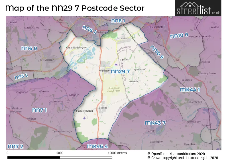
The NN29 7 postcode sector lies where the three counties of Bedfordshire, Buckinghamshire, and Northamptonshire meet.
Did you know? According to the 2021 Census, the NN29 7 postcode sector is home to a bustling 11,812 residents!
Given that each sector allows for 400 unique postcode combinations. Letters C, I, K, M, O and V are not allowed in the last two letters of a postcode. With 274 postcodes already in use, this leaves 126 units available.
The largest settlement in the NN29 7 postal code is Irchester followed by Wollaston, and Bozeat.
The NN29 7 Postcode shares a border with MK43 7 (Oakley, Harrold, Carlton), MK44 1 (Sharnbrook, Riseley, Milton Ernest), MK46 4 (OLNEY, Lavendon, Cold Brayfield), NN6 0 (Earls Barton, Overstone, Sywell), NN8 1 (WELLINGBOROUGH), NN10 6 (RUSHDEN), NN10 9 (RUSHDEN, Wymington), NN7 1 (Cogenhoe, Yardley Hastings, Denton) and NN8 2 (WELLINGBOROUGH, Wilby, Little Irchester).
The sector is within the post town of WELLINGBOROUGH.
NN29 7 is a postcode sector within the NN29 postcode district which is within the NN Northampton postcode area.
The Royal Mail delivery office for the NN29 7 postal sector is the Wellingborough Delivery Office and Irchester Scale Payment Delivery Office and Wollaston Scale Payment Delivery Office and Bozeat Scale Payment Delivery Office.
The area of the NN29 7 postcode sector is 24.49 square miles which is 63.44 square kilometres or 15,676.42 square acres.
The NN29 7 postcode sector is crossed by the A45 Major A road.
Waterways within the NN29 7 postcode sector include the River Nene.

Map of the NN29 7 Postcode Sector
Explore the NN29 7 postcode sector by using our free interactive map.
| N | N | 2 | 9 | - | 7 | X | X |
| N | N | 2 | 9 | Space | 7 | Letter | Letter |
Official List of Streets
Bozeat (43 Streets)
Wollaston (63 Streets)
Podington (8 Streets)
Irchester (57 Streets)
Great Doddington (17 Streets)
Easton Maudit (1 Streets)
Knuston (3 Streets)
Strixton (1 Streets)
Hinwick (1 Streets)
Unofficial Streets or Alternative Spellings
Wymington
PODINGTON ROADRUSHDEN
IRCHESTER ROADOdell
DUNGEE ROADIrchester
WANTAGE PLACE ABBEY COURT BAKERS CRESCENT BOZEAT BYPASS BOZEAT ROUNDABOUT BRAMLEY COURT CHESTER ROAD DANGER ROCKFALL FISH ALLEY FRANCIS DICKENS CLOSE GLEBE FARM COURT GREEN LANE IS THIS STILL VALID MARYS LANE PEAR TREE CLOSE PEARSON MEWS PUDDING BAG LANE RAILWAY GULLET ROSE CLOSE SAINT MARYS ROAD SAINT MICHAELS LANE ST KATHARINES WAY STONEY PLACE CLOSE WILBY WAY WILBY WAY ROUNDABOUT WINDMILL CLOSE GARAGES WOLLASTON BYPASS WOLLASTON ROUNDABOUTWollaston
CHURCH VIEWWELLINGBOROUGH
CLAUDIUS WAY DODDINGTON ROADDenington Industrial Estate
LONDON ROADBozeat
MALLOWS YARDGrendon
EASTON WAY MAIN ROADGreat Doddington
TOP FARM LANEEarls Barton
DODDINGTON ROADWeather Forecast for NN29 7
Press Button to Show Forecast for Santa Pod Raceway
| Time Period | Icon | Description | Temperature | Rain Probability | Wind |
|---|---|---|---|---|---|
| 06:00 to 09:00 | Cloudy | 4.0°C (feels like 2.0°C) | 4.00% | WSW 7 mph | |
| 09:00 to 12:00 | Cloudy | 7.0°C (feels like 4.0°C) | 13.00% | W 9 mph | |
| 12:00 to 15:00 | Overcast | 9.0°C (feels like 6.0°C) | 14.00% | WNW 11 mph | |
| 15:00 to 18:00 | Light rain | 8.0°C (feels like 5.0°C) | 50.00% | N 9 mph | |
| 18:00 to 21:00 | Cloudy | 7.0°C (feels like 5.0°C) | 7.00% | ENE 7 mph | |
| 21:00 to 00:00 | Partly cloudy (night) | 4.0°C (feels like 2.0°C) | 1.00% | ENE 4 mph |
Press Button to Show Forecast for Santa Pod Raceway
| Time Period | Icon | Description | Temperature | Rain Probability | Wind |
|---|---|---|---|---|---|
| 00:00 to 03:00 | Clear night | 2.0°C (feels like 0.0°C) | 1.00% | ENE 4 mph | |
| 03:00 to 06:00 | Clear night | 0.0°C (feels like -2.0°C) | 1.00% | NNE 4 mph | |
| 06:00 to 09:00 | Sunny day | 2.0°C (feels like 0.0°C) | 1.00% | NNE 4 mph | |
| 09:00 to 12:00 | Sunny day | 7.0°C (feels like 5.0°C) | 1.00% | NE 7 mph | |
| 12:00 to 15:00 | Cloudy | 9.0°C (feels like 8.0°C) | 10.00% | ENE 4 mph | |
| 15:00 to 18:00 | Overcast | 10.0°C (feels like 8.0°C) | 10.00% | NE 7 mph | |
| 18:00 to 21:00 | Cloudy | 8.0°C (feels like 6.0°C) | 10.00% | ENE 7 mph | |
| 21:00 to 00:00 | Cloudy | 5.0°C (feels like 3.0°C) | 10.00% | ENE 7 mph |
Press Button to Show Forecast for Santa Pod Raceway
| Time Period | Icon | Description | Temperature | Rain Probability | Wind |
|---|---|---|---|---|---|
| 00:00 to 03:00 | Cloudy | 4.0°C (feels like 2.0°C) | 11.00% | ENE 4 mph | |
| 03:00 to 06:00 | Cloudy | 3.0°C (feels like 0.0°C) | 13.00% | NE 7 mph | |
| 06:00 to 09:00 | Cloudy | 4.0°C (feels like 1.0°C) | 16.00% | NE 7 mph | |
| 09:00 to 12:00 | Overcast | 8.0°C (feels like 5.0°C) | 22.00% | ENE 9 mph | |
| 12:00 to 15:00 | Overcast | 10.0°C (feels like 8.0°C) | 23.00% | ENE 11 mph | |
| 15:00 to 18:00 | Overcast | 11.0°C (feels like 9.0°C) | 21.00% | ENE 11 mph | |
| 18:00 to 21:00 | Cloudy | 9.0°C (feels like 7.0°C) | 20.00% | NE 11 mph | |
| 21:00 to 00:00 | Light rain | 7.0°C (feels like 4.0°C) | 55.00% | NE 11 mph |
Press Button to Show Forecast for Santa Pod Raceway
| Time Period | Icon | Description | Temperature | Rain Probability | Wind |
|---|---|---|---|---|---|
| 00:00 to 03:00 | Light rain | 7.0°C (feels like 4.0°C) | 49.00% | NE 11 mph | |
| 03:00 to 06:00 | Heavy rain | 7.0°C (feels like 4.0°C) | 79.00% | NE 11 mph | |
| 06:00 to 09:00 | Heavy rain | 8.0°C (feels like 6.0°C) | 76.00% | ESE 9 mph | |
| 09:00 to 12:00 | Light rain | 10.0°C (feels like 8.0°C) | 50.00% | S 11 mph | |
| 12:00 to 15:00 | Light rain shower (day) | 12.0°C (feels like 10.0°C) | 43.00% | SSW 9 mph | |
| 15:00 to 18:00 | Heavy rain shower (day) | 12.0°C (feels like 9.0°C) | 62.00% | W 11 mph | |
| 18:00 to 21:00 | Light rain shower (day) | 10.0°C (feels like 8.0°C) | 36.00% | WSW 11 mph | |
| 21:00 to 00:00 | Cloudy | 8.0°C (feels like 6.0°C) | 9.00% | WSW 7 mph |
Schools and Places of Education Within the NN29 7 Postcode Sector
Bozeat Community Primary School
Academy converter
Harrold Road, Wellingborough, Northamptonshire, NN29 7LP
Head: Mr Gareth Rust
Ofsted Rating: Good
Inspection: 2023-09-21 (217 days ago)
Website: Visit Bozeat Community Primary School Website
Phone: 01933663840
Number of Pupils: 134
Christopher Reeves CofE VA Primary School
Voluntary aided school
Hinwick Road, Wellingborough, Northamptonshire, NN29 7HU
Head: Mrs Sarah Bush
Ofsted Rating: Good
Inspection: 2018-10-09 (2025 days ago)
Website: Visit Christopher Reeves CofE VA Primary School Website
Phone: 01933353531
Number of Pupils: 80
Great Doddington Primary
Community school
Church Lane, Wellingborough, Northamptonshire, NN29 7TR
Head: Mrs Josie Garnham
Ofsted Rating: Requires improvement
Inspection: 2023-01-25 (456 days ago)
Website: Visit Great Doddington Primary Website
Phone: 01933225814
Number of Pupils: 138
Irchester Community Primary School
Academy converter
School Lane, Wellingborough, Northamptonshire, NN29 7AZ
Head: Mr Simon Anderson
Ofsted Rating: Good
Inspection: 2023-06-23 (307 days ago)
Website: Visit Irchester Community Primary School Website
Phone: 01933353848
Number of Pupils: 377
Wollaston Primary School
Academy converter
College Street, Wellingborough, Northamptonshire, NN29 7SF
Head: Mrs Zoe Richards
Ofsted Rating: Good
Inspection: 2023-10-11 (197 days ago)
Website: Visit Wollaston Primary School Website
Phone: 01933664291
Number of Pupils: 298
Wollaston School
Academy converter
Irchester Road, Wellingborough, Northamptonshire, NN29 7PH
Head: Mr Simon Anderson
Ofsted Rating: Good
Inspection: 2023-05-17 (344 days ago)
Website: Visit Wollaston School Website
Phone: 01933663501
Number of Pupils: 1410
House Prices in the NN29 7 Postcode Sector
| Type of Property | 2018 Average | 2018 Sales | 2017 Average | 2017 Sales | 2016 Average | 2016 Sales | 2015 Average | 2015 Sales |
|---|---|---|---|---|---|---|---|---|
| Detached | £373,267 | 66 | £299,509 | 64 | £328,266 | 60 | £333,291 | 76 |
| Semi-Detached | £231,009 | 66 | £218,595 | 82 | £180,868 | 81 | £178,720 | 84 |
| Terraced | £201,890 | 55 | £195,135 | 51 | £174,981 | 64 | £174,136 | 58 |
| Flats | £108,999 | 7 | £138,914 | 7 | £119,333 | 6 | £108,500 | 10 |
Important Postcodes NN29 7 in the Postcode Sector
NN29 7AZ is the postcode for KEYSTAGE 2, Irchester Community Primary School, School Lane, Northamptonshire County Council, Irchester Junior School, School Lane, KEYSTAGE 1, Irchester Community Primary School, School Lane, and Irchester Community Primary School, School Lane
NN29 7DL is the postcode for Irchester Country Park, Gipsey Lane, Irchester
NN29 7EU is the postcode for MAIN BUILDING - BLOCK A0, Knuston Adult Residential College & Training Centre, Knuston Hall,, Knuston Adult Residential College & Training Centre, Knuston Hall, Knuston, and Knuston Adult Residential College & Training Centre, Knuston Hall,
NN29 7LP is the postcode for Bozeat Primary School, Harrold Road
NN29 7PH is the postcode for BUILDING C0, Wollaston School, Irchester Road, GYM, Wollaston School, Irchester Road, BUILDING P1, Wollaston School, Irchester Road, BUILDING A0, Wollaston School, Irchester Road, BUILDING E0, Wollaston School, Irchester Road, BUILDING B0, Wollaston School, Irchester Road, and Wollaston School, Irchester Road
NN29 7SF is the postcode for Wollaston Community Primary School, College Street, and Wollaston Community Primary School, College Street, Wollaston
NN29 7TR is the postcode for Great Doddington Primary School, Church Lane
| The NN29 7 Sector is within these Local Authorities |
|
|---|---|
| The NN29 7 Sector is within these Counties |
|
| The NN29 7 Sector is within these Water Company Areas |
|