The NP18 postcode district is a postal district located in the NP Newport postcode area with a population of 17,047 residents according to the 2021 England and Wales Census.
The area of the NP18 postcode district is 30.05 square miles which is 77.83 square kilometres or 19,231.73 acres.
Currently, the NP18 district has about 475 postcode units spread across 3 geographic postcode sectors.
Given that each sector allows for 400 unique postcode combinations, the district has a capacity of 1,200 postcodes. With 475 postcodes already in use, this leaves 725 units available.
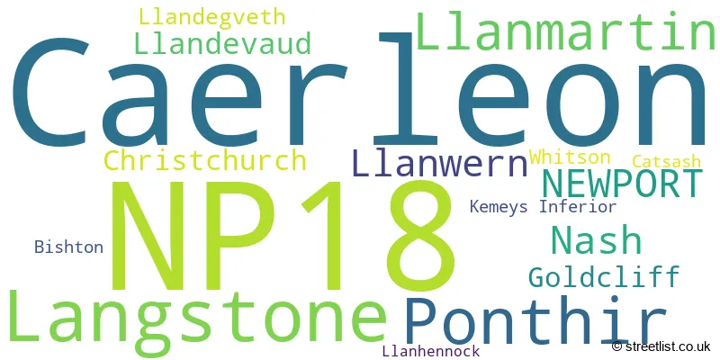
The largest settlement in the NP18 postal code is CAERLEON followed by LANGSTONE, and NEWPORT.
The postcode area has a boundary with The Bristol Channel.
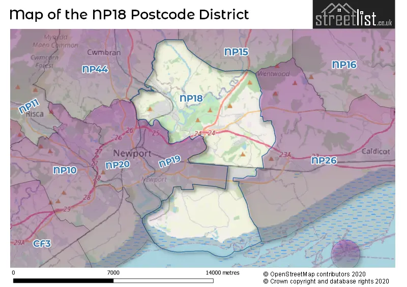
The NP18 Postcode shares a border with NP15 (USK, Raglan, LLANGYBI), NP44 (CWMBRAN, Pontnewydd, CROESYCEILIOG), NP26 (CALDICOT, UNDY, MAGOR) and NP19 (NEWPORT, LLANWERN).
The primary settlement in the NP18 postcode district is Caerleon, located in the county of Gwent, Wales. Other significant settlements in this district include Bishton, Goldcliff, Langstone, Llandevaud, Llanmartin, Llanwern, Nash, and Whitson. The main post town for this postcode district is Newport.
For the district NP18, we have data on 3 postcode sectors. Here's a breakdown: The sector NP18 1, covers Caerleon and Ponthir in Gwent. The sector NP18 2, covers Langstone and Llanmartin and Nash in Gwent. The sector NP18 3, covers Caerleon in Gwent.

Map of the NP18 Postcode District
Explore the NP18 postcode district by using our free interactive map.
When it comes to local government, postal geography often disregards political borders. However, for a breakdown in the NP18 District: the district mostly encompasses the Casnewydd - Newport (427 postcodes), followed by the Torfaen - Torfaen area (40 postcodes), and finally, the Sir Fynwy - Monmouthshire area (16 postcodes).
Recent House Sales in NP18
| Date | Price | Address |
|---|---|---|
| 13/10/2023 | £340,000 | Spartan Close, Langstone, Newport, NP18 2BH |
| 10/10/2023 | £375,000 | Owen Close, Caerleon, Newport, NP18 3TH |
| 06/10/2023 | £395,000 | Owen Close, Caerleon, Newport, NP18 3TH |
| 29/09/2023 | £252,000 | Caerleon Road, Newport, NP18 1QA |
| 29/09/2023 | £39,000 | Camelot Court, Caerleon, Newport, NP18 1AP |
| 19/09/2023 | £333,000 | Anthony Drive, Caerleon, Newport, NP18 3EY |
| 19/09/2023 | £600,000 | Priory Gardens, Langstone, Newport, NP18 2JG |
| 01/09/2023 | £270,000 | Orchard Road, Caerleon, Newport, NP18 3FX |
| 01/09/2023 | £570,000 | Cambria Close, Caerleon, Newport, NP18 1LF |
| 01/09/2023 | £220,000 | Waltwood Road, Llanmartin, Newport, NP18 2HN |
Where is the NP18 Postcode District?
The NP18 postcode district is located in the town of Newport. It is situated near several nearby towns. To the East is Monmouth, which is approximately 3.6 miles away. To the North West is Cwmbran, approximately 5.9 miles away. Usk is located to the North and is about 7.3 miles away. Clevedon is to the South and is approximately 12.1 miles away. Finally, Caerphilly is to the West and is about 13.3 miles away. Additionally, the NP18 postcode district is approximately 120.6 miles away from the centre of London.
The district is within the post town of NEWPORT.
The sector has postcodes within the nation of Wales.
The NP18 Postcode District is covers the following regions.
- Monmouthshire and Newport - East Wales - Wales
- Gwent Valleys - West Wales - Wales
| Postcode Sector | Delivery Office |
|---|---|
| NP18 1 | Newport East Delivery Office |
| NP18 2 | Newport East Delivery Office |
| NP18 3 | Newport East Delivery Office |
| N | P | 1 | 8 | - | X | X | X |
| N | P | 1 | 8 | Space | Numeric | Letter | Letter |
Tourist Attractions within the Postcode Area
We found 3 visitor attractions within the NP18 postcode area
| Caerleon Roman Baths and Amphitheatre |
|---|
| View Caerleon Roman Baths and Amphitheatre on Google Maps |
| National Roman Legion Museum |
| View National Roman Legion Museum on Google Maps |
| Newport Wetlands Nature Reserve |
| View Newport Wetlands Nature Reserve on Google Maps |
Current Monthly Rental Prices
| # Bedrooms | Min Price | Max Price | Avg Price |
|---|---|---|---|
| £725 | £725 | £725 | |
| 2 | £750 | £810 | £780 |
| 3 | £1,750 | £1,750 | £1,750 |
| 4 | £1,600 | £1,600 | £1,600 |
Current House Prices
| # Bedrooms | Min Price | Max Price | Avg Price |
|---|---|---|---|
| £120,000 | £120,000 | £120,000 | |
| 2 | £150,000 | £425,000 | £240,663 |
| 3 | £190,000 | £900,000 | £332,466 |
| 4 | £250,000 | £1,100,000 | £468,612 |
| 5 | £450,000 | £2,100,000 | £772,219 |
| 6 | £600,000 | £1,850,000 | £1,283,333 |
| 7 | £699,000 | £2,850,000 | £1,637,250 |
| 8 | £1,300,000 | £4,000,000 | £3,100,000 |
Estate Agents who Operate in the NP18 District
| Logo | Name | Brand Name | Address | Contact Number | Total Properties |
|---|---|---|---|---|---|
 | Newport | M2 Estate Agents | 69 Bridge Street, Newport, NP20 4AQ | 01633 603652 | 14 |
 | Newport | Pinkmove | 30 Bridge Street Newport NP20 4BG | 01633 603386 | 11 |
 | Newport | Number One Real Estate | 76 Bridge Street, Newport, NP20 4AQ | 01633 603687 | 11 |
 | Cardiff | Fine & Country | Sophia House, Cathedral Road, Cardiff, CF11 9LJ | 029 2167 7210 | 10 |
 | Cwmbran | Hathways Estate Agents | 2 New Street, Pontnewydd, Cwmbran, NP44 1EE | 01633 603606 | 10 |
| Type of Property | 2018 Average | 2018 Sales | 2017 Average | 2017 Sales | 2016 Average | 2016 Sales | 2015 Average | 2015 Sales |
|---|---|---|---|---|---|---|---|---|
| Detached | £355,059 | 102 | £313,570 | 172 | £311,866 | 160 | £277,177 | 142 |
| Semi-Detached | £212,577 | 84 | £194,099 | 66 | £172,857 | 87 | £181,905 | 59 |
| Terraced | £186,980 | 59 | £147,961 | 75 | £149,756 | 57 | £144,311 | 61 |
| Flats | £108,652 | 23 | £113,308 | 13 | £102,867 | 9 | £105,208 | 13 |