The NR13 4 postcode sector is within the county of Norfolk.
Did you know? According to the 2021 Census, the NR13 4 postcode sector is home to a bustling 7,903 residents!
Given that each sector allows for 400 unique postcode combinations. Letters C, I, K, M, O and V are not allowed in the last two letters of a postcode. With 275 postcodes already in use, this leaves 125 units available.
The largest settlement in the NR13 4 postal code is Blofield followed by Lingwood, and Strumpshaw.
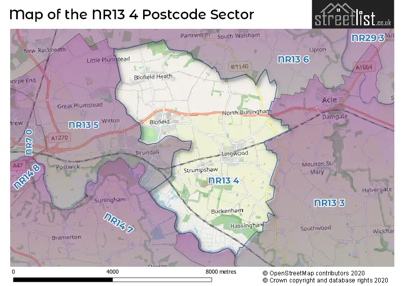
The NR13 4 Postcode shares a border with NR13 3 (Acle, Reedham, Freethorpe), NR13 5 (Brundall, Little Plumstead, Thorpe End), NR13 6 (Rackheath, Salhouse, South Walsham), NR14 6 (Loddon, Chedgrave, Thurlton) and NR14 7 (Poringland, Framingham Earl, Surlingham).
The sector is within the post town of NORWICH.
NR13 4 is a postcode sector within the NR13 postcode district which is within the NR Norwich postcode area.
The Royal Mail delivery office for the NR13 4 postal sector is the Blofield Scale Payment Delivery Office.
The area of the NR13 4 postcode sector is 14.04 square miles which is 36.37 square kilometres or 8,986.14 square acres.
The NR13 4 postcode sector is crossed by the A47 Major A road.
Waterways within the NR13 4 postcode sector include the River Yare.

Map of the NR13 4 Postcode Sector
Explore the NR13 4 postcode sector by using our free interactive map.
| N | R | 1 | 3 | - | 4 | X | X |
| N | R | 1 | 3 | Space | 4 | Letter | Letter |
Official List of Streets
Lingwood (53 Streets)
North Burlingham (8 Streets)
Blofield (92 Streets)
Strumpshaw (21 Streets)
Hemblington (8 Streets)
South Burlingham (6 Streets)
Buckenham (5 Streets)
Hassingham (4 Streets)
Unofficial Streets or Alternative Spellings
South Walsham
BURLINGHAM ROAD GREEN LANE NEWPORT ROAD BELT ROAD BRAYDESTON HALL LANE CHAPEL COURT CHURCH LANE DAWSONS LANE FOXWOOD GOAT LANE HEATH LANE HIGH NOON LANE MEWS COURT MILL HILL ORCHARD ROAD PLUMSTEAD ROAD POND LANE SAINT ANDREWS CLOSE SAINT ANDREWS ROAD SAINT ANDREWS WAY SAINT EDMUNDS ROAD SAINT PETERS CLOSE SAINT PETERS ROAD STONE ROAD STRUMPSHAW STABLES WORLDS END LANEBeighton
COXHILL ROAD HIGH ROAD LINGWOOD LONG LANE OLD SOUTHWOOD ROADAcle
NORWICH ROADHemblington
DUNCH CRESCENTBrundall
STRUMPSHAW ROADWoodbastwick
PRIMROSE CORNERLittle Plumstead
POST OFFICE ROAD SCHOOL ROADWeather Forecast for NR13 4
Press Button to Show Forecast for Fairhaven Gardens (South Walsham)
| Time Period | Icon | Description | Temperature | Rain Probability | Wind |
|---|---|---|---|---|---|
| 00:00 to 03:00 | Partly cloudy (night) | 4.0°C (feels like 1.0°C) | 5.00% | W 7 mph | |
| 03:00 to 06:00 | Cloudy | 4.0°C (feels like 1.0°C) | 5.00% | WSW 7 mph | |
| 06:00 to 09:00 | Cloudy | 5.0°C (feels like 2.0°C) | 5.00% | SW 9 mph | |
| 09:00 to 12:00 | Cloudy | 8.0°C (feels like 5.0°C) | 9.00% | W 13 mph | |
| 12:00 to 15:00 | Heavy rain | 7.0°C (feels like 4.0°C) | 79.00% | NNW 11 mph | |
| 15:00 to 18:00 | Overcast | 7.0°C (feels like 4.0°C) | 17.00% | NW 9 mph | |
| 18:00 to 21:00 | Partly cloudy (day) | 6.0°C (feels like 4.0°C) | 2.00% | NNW 7 mph | |
| 21:00 to 00:00 | Clear night | 3.0°C (feels like 1.0°C) | 0.00% | WNW 4 mph |
Press Button to Show Forecast for Fairhaven Gardens (South Walsham)
| Time Period | Icon | Description | Temperature | Rain Probability | Wind |
|---|---|---|---|---|---|
| 00:00 to 03:00 | Clear night | 3.0°C (feels like 0.0°C) | 1.00% | WNW 4 mph | |
| 03:00 to 06:00 | Partly cloudy (night) | 2.0°C (feels like 0.0°C) | 1.00% | WNW 4 mph | |
| 06:00 to 09:00 | Cloudy | 5.0°C (feels like 3.0°C) | 4.00% | NW 4 mph | |
| 09:00 to 12:00 | Cloudy | 8.0°C (feels like 6.0°C) | 49.00% | NE 7 mph | |
| 12:00 to 15:00 | Cloudy | 9.0°C (feels like 7.0°C) | 7.00% | ENE 7 mph | |
| 15:00 to 18:00 | Overcast | 9.0°C (feels like 7.0°C) | 11.00% | ENE 7 mph | |
| 18:00 to 21:00 | Cloudy | 8.0°C (feels like 6.0°C) | 6.00% | ENE 7 mph | |
| 21:00 to 00:00 | Partly cloudy (night) | 5.0°C (feels like 2.0°C) | 4.00% | ENE 7 mph |
Press Button to Show Forecast for Fairhaven Gardens (South Walsham)
| Time Period | Icon | Description | Temperature | Rain Probability | Wind |
|---|---|---|---|---|---|
| 00:00 to 03:00 | Partly cloudy (night) | 5.0°C (feels like 4.0°C) | 6.00% | ENE 4 mph | |
| 03:00 to 06:00 | Partly cloudy (night) | 4.0°C (feels like 1.0°C) | 9.00% | NE 7 mph | |
| 06:00 to 09:00 | Cloudy | 7.0°C (feels like 5.0°C) | 11.00% | ENE 7 mph | |
| 09:00 to 12:00 | Cloudy | 9.0°C (feels like 7.0°C) | 15.00% | ENE 9 mph | |
| 12:00 to 15:00 | Cloudy | 11.0°C (feels like 9.0°C) | 13.00% | ENE 9 mph | |
| 15:00 to 18:00 | Cloudy | 11.0°C (feels like 9.0°C) | 11.00% | ENE 9 mph | |
| 18:00 to 21:00 | Cloudy | 10.0°C (feels like 8.0°C) | 11.00% | ENE 11 mph | |
| 21:00 to 00:00 | Light rain | 9.0°C (feels like 7.0°C) | 50.00% | ENE 11 mph |
Press Button to Show Forecast for Fairhaven Gardens (South Walsham)
| Time Period | Icon | Description | Temperature | Rain Probability | Wind |
|---|---|---|---|---|---|
| 00:00 to 03:00 | Light rain | 10.0°C (feels like 7.0°C) | 51.00% | E 11 mph | |
| 03:00 to 06:00 | Light rain | 10.0°C (feels like 8.0°C) | 51.00% | ESE 11 mph | |
| 06:00 to 09:00 | Light rain shower (day) | 11.0°C (feels like 8.0°C) | 42.00% | SSE 11 mph | |
| 09:00 to 12:00 | Light rain shower (day) | 13.0°C (feels like 10.0°C) | 37.00% | SSE 13 mph | |
| 12:00 to 15:00 | Light rain shower (day) | 14.0°C (feels like 11.0°C) | 40.00% | S 16 mph | |
| 15:00 to 18:00 | Heavy rain shower (day) | 13.0°C (feels like 10.0°C) | 58.00% | SSW 16 mph | |
| 18:00 to 21:00 | Light rain shower (day) | 12.0°C (feels like 10.0°C) | 31.00% | SSW 11 mph | |
| 21:00 to 00:00 | Clear night | 9.0°C (feels like 7.0°C) | 6.00% | SW 9 mph |
Schools and Places of Education Within the NR13 4 Postcode Sector
Blofield Primary School
Community school
North Street, Norwich, Norfolk, NR13 4RH
Head: Mrs Teresa Doggett
Ofsted Rating: Good
Inspection: 2019-03-07 (1876 days ago)
Website: Visit Blofield Primary School Website
Phone: 01603713386
Number of Pupils: 214
Hemblington Primary School
Academy converter
Mill Road, Norwich, Norfolk, NR13 4QJ
Head: Mrs Louise Norgate
Ofsted Rating: Requires improvement
Inspection: 2021-10-13 (925 days ago)
Website: Visit Hemblington Primary School Website
Phone: 01603713243
Number of Pupils: 143
Lingwood Primary Academy
Academy sponsor led
Station Road, Lingwood, Norfolk, NR13 4AZ
Head: Miss Caroline Laycock
Ofsted Rating: Good
Inspection: 2018-06-08 (2148 days ago)
Website: Visit Lingwood Primary Academy Website
Phone: 01603712295
Number of Pupils: 221
House Prices in the NR13 4 Postcode Sector
| Type of Property | 2018 Average | 2018 Sales | 2017 Average | 2017 Sales | 2016 Average | 2016 Sales | 2015 Average | 2015 Sales |
|---|---|---|---|---|---|---|---|---|
| Detached | £342,153 | 86 | £371,482 | 75 | £330,134 | 74 | £285,551 | 94 |
| Semi-Detached | £241,159 | 50 | £224,984 | 34 | £195,469 | 26 | £200,103 | 33 |
| Terraced | £212,061 | 11 | £283,974 | 19 | £173,192 | 13 | £177,010 | 14 |
| Flats | £275,000 | 2 | £0 | 0 | £0 | 0 | £105,000 | 1 |
Important Postcodes NR13 4 in the Postcode Sector
NR13 4AZ is the postcode for Lingwood Primary Academy, Station Road, Lingwood, and Lingwood Primary Academy, Station Road
NR13 4PL is the postcode for The Blofield Surgery, Plantation Road
NR13 4QJ is the postcode for Hemblington Cp School, Mill Road
NR13 4RH is the postcode for Blofield Cp School, North Street, and Blofield Primary School, North Street
NR13 4TJ is the postcode for Compass Lingwood, School Road
| The NR13 4 Sector is within these Local Authorities |
|
|---|---|
| The NR13 4 Sector is within these Counties |
|
| The NR13 4 Sector is within these Water Company Areas |
|