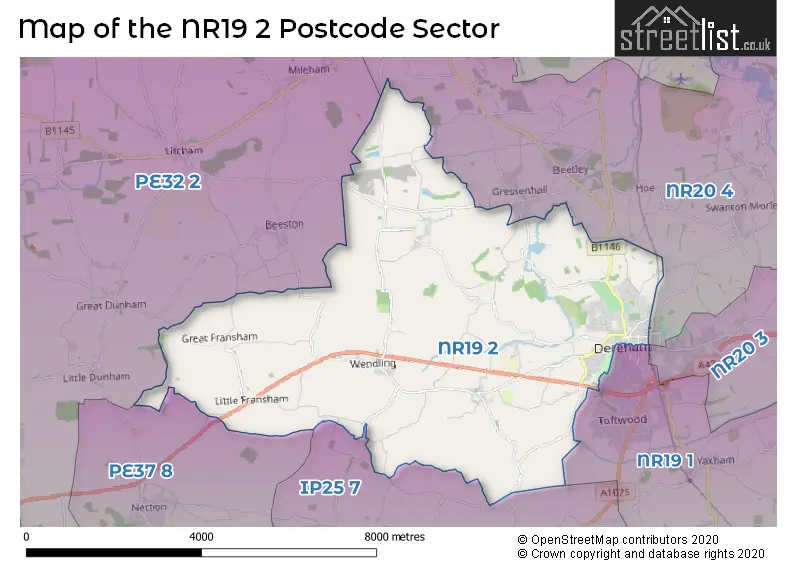
The NR19 2 postcode sector is within the county of Norfolk.
Did you know? According to the 2021 Census, the NR19 2 postcode sector is home to a bustling 9,314 residents!
Given that each sector allows for 400 unique postcode combinations. Letters C, I, K, M, O and V are not allowed in the last two letters of a postcode. With 290 postcodes already in use, this leaves 110 units available.
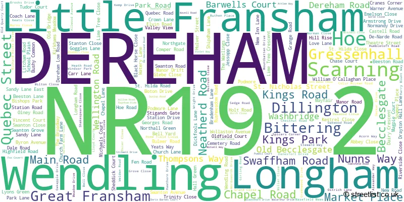
The largest settlement in the NR19 2 postal code is DEREHAM followed by Scarning, and Little Fransham.
The NR19 2 Postcode shares a border with NR19 1 (DEREHAM, Yaxham, Westfield), NR20 4 (Swanton Morley, Beetley, Gressenhall), PE32 2 (Sporle, Castle Acre, Great Massingham), PE37 8 (SWAFFHAM, Necton, North Pickenham) and IP25 7 (Shipdham, Ashill, Saham Toney).
The sector is within the post town of DEREHAM.
NR19 2 is a postcode sector within the NR19 postcode district which is within the NR Norwich postcode area.
The Royal Mail delivery office for the NR19 2 postal sector is the Dereham Delivery Office.
The area of the NR19 2 postcode sector is 20.91 square miles which is 54.17 square kilometres or 13,385.12 square acres.
The NR19 2 postcode sector is crossed by the A47 Major A road.

Map of the NR19 2 Postcode Sector
Explore the NR19 2 postcode sector by using our free interactive map.
| N | R | 1 | 9 | - | 2 | X | X |
| N | R | 1 | 9 | Space | 2 | Letter | Letter |
Official List of Streets
Wendling (9 Streets)
DEREHAM (95 Streets)
Scarning (58 Streets)
Great Fransham (6 Streets)
Gressenhall (6 Streets)
Longham (8 Streets)
Little Fransham (10 Streets)
Unofficial Streets or Alternative Spellings
DEREHAM
CHURCH STREET DE-NARDE ROAD HERNE LANE HIGH STREET NELSON PLACE BACK LANE BEETLEY ROAD BITTERING LANE BLOOMFIELD MEWS CORDYS LANE DEREHAM LANE FRANSHAM ROAD GLENCOE COURT GOLF LANE GREEN LANE GREEN WOOD DRIVE GRESSENHALL ROAD HAGGARDS WAY HONEYPOT LANE LAYBY LONGHAM LANE MANOR FARM LANE MICHAEL MONUMENT COURT MILL CLOSE MOOR LANE PAGES YARD PROVIDENCE DRIVE RED LION STREET RIVERSIDE SAINT HILDA CLOSE SAINT HILDA ROAD SAINT NICHOLAS STREET SALTERS LANE SHIPDHAM ROAD SNOWHILL DRIFT ST MICHAELS COURT STONEY LANE TAYLORS LANE TED ELLIS WALK THE MALTINGS TURNING WATLINGS LANE YORK PLACEGressenhall
BRIDGE STREET LITCHAM ROADBeetley
HOLT ROAD RAWHALL LANEHoe
GORGATE DRIVE MILL LANEStanfield
REED LANEBeeston
DEREHAM ROADWeather Forecast for NR19 2
Press Button to Show Forecast for Dereham
| Time Period | Icon | Description | Temperature | Rain Probability | Wind |
|---|---|---|---|---|---|
| 15:00 to 18:00 | Cloudy | 7.0°C (feels like 4.0°C) | 12.00% | NNW 9 mph | |
| 18:00 to 21:00 | Partly cloudy (day) | 6.0°C (feels like 4.0°C) | 2.00% | N 7 mph | |
| 21:00 to 00:00 | Partly cloudy (night) | 2.0°C (feels like 1.0°C) | 0.00% | NNW 4 mph |
Press Button to Show Forecast for Dereham
| Time Period | Icon | Description | Temperature | Rain Probability | Wind |
|---|---|---|---|---|---|
| 00:00 to 03:00 | Clear night | 1.0°C (feels like -1.0°C) | 0.00% | WNW 4 mph | |
| 03:00 to 06:00 | Clear night | 1.0°C (feels like -2.0°C) | 1.00% | WNW 4 mph | |
| 06:00 to 09:00 | Partly cloudy (day) | 3.0°C (feels like 2.0°C) | 1.00% | NW 4 mph | |
| 09:00 to 12:00 | Cloudy | 7.0°C (feels like 6.0°C) | 5.00% | NNE 7 mph | |
| 12:00 to 15:00 | Overcast | 9.0°C (feels like 7.0°C) | 10.00% | NE 7 mph | |
| 15:00 to 18:00 | Light rain shower (day) | 9.0°C (feels like 7.0°C) | 31.00% | ENE 7 mph | |
| 18:00 to 21:00 | Cloudy | 8.0°C (feels like 6.0°C) | 8.00% | E 7 mph | |
| 21:00 to 00:00 | Cloudy | 4.0°C (feels like 2.0°C) | 7.00% | ENE 4 mph |
Press Button to Show Forecast for Dereham
| Time Period | Icon | Description | Temperature | Rain Probability | Wind |
|---|---|---|---|---|---|
| 00:00 to 03:00 | Partly cloudy (night) | 3.0°C (feels like 1.0°C) | 6.00% | NE 4 mph | |
| 03:00 to 06:00 | Partly cloudy (night) | 3.0°C (feels like 1.0°C) | 8.00% | NE 4 mph | |
| 06:00 to 09:00 | Cloudy | 5.0°C (feels like 3.0°C) | 12.00% | ENE 7 mph | |
| 09:00 to 12:00 | Cloudy | 9.0°C (feels like 7.0°C) | 18.00% | ENE 9 mph | |
| 12:00 to 15:00 | Overcast | 11.0°C (feels like 9.0°C) | 16.00% | ENE 9 mph | |
| 15:00 to 18:00 | Overcast | 11.0°C (feels like 9.0°C) | 15.00% | ENE 9 mph | |
| 18:00 to 21:00 | Cloudy | 10.0°C (feels like 7.0°C) | 14.00% | ENE 11 mph | |
| 21:00 to 00:00 | Light rain | 8.0°C (feels like 6.0°C) | 50.00% | ENE 9 mph |
Press Button to Show Forecast for Dereham
| Time Period | Icon | Description | Temperature | Rain Probability | Wind |
|---|---|---|---|---|---|
| 00:00 to 03:00 | Light rain | 9.0°C (feels like 6.0°C) | 51.00% | NE 11 mph | |
| 03:00 to 06:00 | Heavy rain | 9.0°C (feels like 7.0°C) | 72.00% | E 9 mph | |
| 06:00 to 09:00 | Light rain | 10.0°C (feels like 8.0°C) | 51.00% | SE 11 mph | |
| 09:00 to 12:00 | Light rain shower (day) | 12.0°C (feels like 10.0°C) | 41.00% | SSE 11 mph | |
| 12:00 to 15:00 | Light rain shower (day) | 13.0°C (feels like 10.0°C) | 42.00% | SSE 13 mph | |
| 15:00 to 18:00 | Heavy rain shower (day) | 12.0°C (feels like 10.0°C) | 57.00% | SW 13 mph | |
| 18:00 to 21:00 | Light rain shower (day) | 11.0°C (feels like 9.0°C) | 32.00% | WSW 11 mph | |
| 21:00 to 00:00 | Clear night | 8.0°C (feels like 6.0°C) | 5.00% | SW 9 mph |
Schools and Places of Education Within the NR19 2 Postcode Sector
King's Park Infant School, Dereham
Academy converter
Kings Park, Dereham, Norfolk, NR19 2AG
Head: Mr Mark Cuenca-Farrow
Ofsted Rating: Good
Inspection: 2020-01-21 (1556 days ago)
Website: Visit King's Park Infant School, Dereham Website
Phone: 01362694077
Number of Pupils: 56
Northgate High School
Academy converter
Cemetery Road, Dereham, Norfolk, NR19 2EU
Head: Mrs Zoe Galley & Dr Duncan Hone
Ofsted Rating: Good
Inspection: 2023-05-24 (337 days ago)
Website: Visit Northgate High School Website
Phone: 01362697033
Number of Pupils: 1129
Scarning Voluntary Controlled Primary School
Voluntary controlled school
Dereham Road, Dereham, Norfolk, NR19 2PW
Head: Mr Nick King
Ofsted Rating: Good
Inspection: 2018-03-27 (2221 days ago)
Website: Visit Scarning Voluntary Controlled Primary School Website
Phone: 01362692665
Number of Pupils: 414
House Prices in the NR19 2 Postcode Sector
| Type of Property | 2018 Average | 2018 Sales | 2017 Average | 2017 Sales | 2016 Average | 2016 Sales | 2015 Average | 2015 Sales |
|---|---|---|---|---|---|---|---|---|
| Detached | £290,689 | 70 | £283,619 | 66 | £273,656 | 86 | £252,822 | 82 |
| Semi-Detached | £181,650 | 40 | £178,281 | 42 | £170,802 | 50 | £163,185 | 42 |
| Terraced | £168,674 | 33 | £164,775 | 42 | £142,406 | 32 | £143,711 | 50 |
| Flats | £87,813 | 8 | £93,035 | 13 | £89,615 | 13 | £86,167 | 9 |
Important Postcodes NR19 2 in the Postcode Sector
NR19 2AA is the postcode for Royal Mail, Dereham Delivery Office, Quebec Street
NR19 2AG is the postcode for King's Park Infant School, Kings Road
NR19 2EU is the postcode for FOOD, NUTRITION, ART & ICT BLOCK, Northgate High School, Northgate, MAIN BLOCK, Northgate High School, Northgate, LIBRARY/DRAMA BLOCK, Northgate High School, Northgate, ART DESIGN TECHNOLOGY BLOCK, Northgate High School, Northgate, ART DESIGN & TECHNOLOGY BLOCK, Northgate High School, Northgate, DRAMA / LIBRARY BLOCK, Northgate High School, Northgate, FOOD, NUTRITION AND ART GRAPHICS AND ICT BLOCK, Northgate High School, Northgate, and ANNE GREGORY BUILDING, Northgate High School, Northgate
NR19 2EX is the postcode for FOXLEY WARD, Norfolk Community Health and Care NHS Trust, Dereham Hospital, Norfolk Community Health and Care NHS Trust, Dereham Hospital, Westfield Centre, Norfolk Community Health and Care NHS Trust, Dereham Hospital, BEETLEY PHYSIO, Norfolk Community Health and Care NHS Trust, Dereham Hospital, and ADMINISTRATION BLOCK, Norfolk Community Health and Care NHS Trust, Dereham Hospital
NR19 2PW is the postcode for Scarning VC Primary School, Dereham Road, Scarning, Scarning VC Primary School, Dereham Road, and MAIN BLOCK, Scarning VC Primary School, Dereham Road
| The NR19 2 Sector is within these Local Authorities |
|
|---|---|
| The NR19 2 Sector is within these Counties |
|
| The NR19 2 Sector is within these Water Company Areas |
|