The NR20 postcode district is a postal district located in the NR Norwich postcode area with a population of 20,310 residents according to the 2021 England and Wales Census.
The area of the NR20 postcode district is 85.45 square miles which is 221.32 square kilometres or 54,688.78 acres.
Currently, the NR20 district has about 825 postcode units spread across 3 geographic postcode sectors.
Given that each sector allows for 400 unique postcode combinations, the district has a capacity of 1,200 postcodes. With 825 postcodes already in use, this leaves 375 units available.
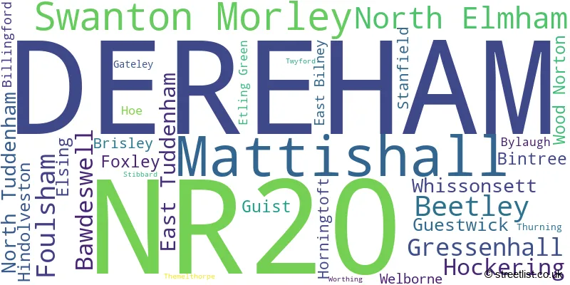
The largest settlement in the NR20 postal code is DEREHAM followed by Mattishall, and Swanton Morley.
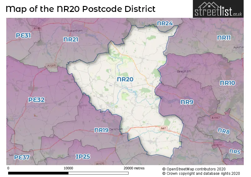
The NR20 Postcode shares a border with PE32 (Gayton, Narborough, Sporle), NR19 (DEREHAM, Scarning, Yaxham), NR21 (FAKENHAM, Sculthorpe, South Creake), NR10 (Horsford, Spixworth, Reepham), NR9 (Hethersett, Hingham, Easton), NR24 (Briston, MELTON CONSTABLE, Edgefield) and NR11 (Aylsham, Mundesley, Southrepps).
The primary settlement in the NR20 postcode district is Dereham, located in the county of Norfolk, England. Other significant settlements in this district include East Tuddenham, Elsing, Etling Green, Hockering, Mattishall, North Tuddenham, and Welborne. The main post town for this postcode district is Dereham.
For the district NR20, we have data on 3 postcode sectors. Here's a breakdown: The sector NR20 3, covers Mattishall and Dereham and Hockering in Norfolk. The sector NR20 4, covers Swanton Morley and Beetley and Gressenhall and Bawdeswell in Norfolk. The sector NR20 5, covers North Elmham and Foulsham in Norfolk.

Map of the NR20 Postcode District
Explore the NR20 postcode district by using our free interactive map.
When it comes to local government, postal geography often disregards political borders. However, for a breakdown in the NR20 District: the district mostly encompasses the Breckland District (729 postcodes), followed by the Broadland District area (62 postcodes), followed by the North Norfolk District area (47 postcodes), and finally, the South Norfolk District area (11 postcodes).
Recent House Sales in NR20
| Date | Price | Address |
|---|---|---|
| 20/10/2023 | £245,000 | Hornbeam Drive, Dereham, NR20 3FQ |
| 03/10/2023 | £77,087 | Manor Close, Hockering, Dereham, NR20 3HU |
| 29/09/2023 | £242,000 | Silver Birch Road, Dereham, NR20 3GL |
| 21/09/2023 | £203,000 | Magnolia Mews, Swanton Morley, Dereham, NR20 4FH |
| 21/09/2023 | £395,000 | East Bilney, Dereham, NR20 4HS |
| 20/09/2023 | £360,000 | Ringers Close, Mattishall, Dereham, NR20 3BF |
| 08/09/2023 | £280,000 | Church Road, Gateley, Dereham, NR20 5EH |
| 01/09/2023 | £550,000 | Greenfields Road, Dereham, NR20 3TE |
| 01/09/2023 | £220,000 | Gordon Road, Dereham, NR20 4AW |
| 29/08/2023 | £265,000 | Chapel Lane, Hockering, Dereham, NR20 3HR |
Weather Forecast for NR20
Press Button to Show Forecast for Beetley
| Time Period | Icon | Description | Temperature | Rain Probability | Wind |
|---|---|---|---|---|---|
| 21:00 to 00:00 | Partly cloudy (night) | 2.0°C (feels like 0.0°C) | 0.00% | NW 4 mph |
Press Button to Show Forecast for Beetley
| Time Period | Icon | Description | Temperature | Rain Probability | Wind |
|---|---|---|---|---|---|
| 00:00 to 03:00 | Partly cloudy (night) | 1.0°C (feels like -1.0°C) | 0.00% | NW 4 mph | |
| 03:00 to 06:00 | Partly cloudy (night) | 1.0°C (feels like -2.0°C) | 1.00% | WNW 4 mph | |
| 06:00 to 09:00 | Partly cloudy (day) | 4.0°C (feels like 2.0°C) | 2.00% | NNW 4 mph | |
| 09:00 to 12:00 | Cloudy | 8.0°C (feels like 6.0°C) | 8.00% | NNE 7 mph | |
| 12:00 to 15:00 | Overcast | 9.0°C (feels like 7.0°C) | 13.00% | NE 7 mph | |
| 15:00 to 18:00 | Light rain shower (day) | 9.0°C (feels like 7.0°C) | 30.00% | ENE 7 mph | |
| 18:00 to 21:00 | Cloudy | 8.0°C (feels like 6.0°C) | 8.00% | E 7 mph | |
| 21:00 to 00:00 | Cloudy | 4.0°C (feels like 2.0°C) | 5.00% | ENE 7 mph |
Press Button to Show Forecast for Beetley
| Time Period | Icon | Description | Temperature | Rain Probability | Wind |
|---|---|---|---|---|---|
| 00:00 to 03:00 | Partly cloudy (night) | 3.0°C (feels like 1.0°C) | 5.00% | NE 4 mph | |
| 03:00 to 06:00 | Cloudy | 3.0°C (feels like 1.0°C) | 10.00% | ENE 7 mph | |
| 06:00 to 09:00 | Cloudy | 6.0°C (feels like 3.0°C) | 11.00% | ENE 7 mph | |
| 09:00 to 12:00 | Cloudy | 9.0°C (feels like 7.0°C) | 17.00% | ENE 9 mph | |
| 12:00 to 15:00 | Overcast | 11.0°C (feels like 9.0°C) | 17.00% | ENE 9 mph | |
| 15:00 to 18:00 | Overcast | 11.0°C (feels like 9.0°C) | 17.00% | ENE 11 mph | |
| 18:00 to 21:00 | Cloudy | 9.0°C (feels like 7.0°C) | 15.00% | ENE 11 mph | |
| 21:00 to 00:00 | Light rain | 8.0°C (feels like 5.0°C) | 49.00% | ENE 11 mph |
Press Button to Show Forecast for Beetley
| Time Period | Icon | Description | Temperature | Rain Probability | Wind |
|---|---|---|---|---|---|
| 00:00 to 03:00 | Light rain | 9.0°C (feels like 6.0°C) | 50.00% | NE 11 mph | |
| 03:00 to 06:00 | Light rain | 9.0°C (feels like 7.0°C) | 50.00% | E 11 mph | |
| 06:00 to 09:00 | Light rain | 10.0°C (feels like 8.0°C) | 53.00% | SE 11 mph | |
| 09:00 to 12:00 | Light rain shower (day) | 12.0°C (feels like 10.0°C) | 37.00% | SSE 13 mph | |
| 12:00 to 15:00 | Light rain shower (day) | 13.0°C (feels like 10.0°C) | 42.00% | S 13 mph | |
| 15:00 to 18:00 | Light rain shower (day) | 12.0°C (feels like 10.0°C) | 41.00% | SW 13 mph | |
| 18:00 to 21:00 | Light rain shower (day) | 11.0°C (feels like 9.0°C) | 33.00% | WSW 11 mph | |
| 21:00 to 00:00 | Clear night | 8.0°C (feels like 6.0°C) | 5.00% | SW 9 mph |
Where is the NR20 Postcode District?
The postcode district NR20 is located in the town of Dereham. It is situated in close proximity to several nearby towns, including Melton Constable to the north, Fakenham to the northwest, Wymondham to the southeast, Swaffham to the southwest, and Attleborough to the south. Additionally, the distance from NR20 to the center of London is approximately 97.54 miles.
The district is within the post town of DEREHAM.
The sector has postcodes within the nation of England.
The NR20 Postcode District is covers the following regions.
- Breckland and South Norfolk - East Anglia - East of England
- Norwich and East Norfolk - East Anglia - East of England
- North and West Norfolk - East Anglia - East of England
| Postcode Sector | Delivery Office |
|---|---|
| NR20 3 | Mattishall Scale Payment Delivery Office |
| NR20 3 | Dereham Delivery Office |
| NR20 4 | Dereham Delivery Office |
| NR20 5 | Dereham Delivery Office |
| N | R | 2 | 0 | - | X | X | X |
| N | R | 2 | 0 | Space | Numeric | Letter | Letter |
Tourist Attractions within the Postcode Area
We found 1 visitor attractions within the NR20 postcode area
| Gressenhall Farm & Workhouse |
|---|
| Museums & Art Galleries |
| Museum and / or Art Gallery |
| View Gressenhall Farm & Workhouse on Google Maps |
Current Monthly Rental Prices
| # Bedrooms | Min Price | Max Price | Avg Price |
|---|---|---|---|
| 2 | £850 | £850 | £850 |
| 4 | £1,000 | £2,150 | £1,583 |
| 5 | £2,750 | £2,750 | £2,750 |
Current House Prices
| # Bedrooms | Min Price | Max Price | Avg Price |
|---|---|---|---|
| £20,000 | £600,000 | £151,429 | |
| 1 | £140,000 | £140,000 | £140,000 |
| 2 | £96,000 | £525,000 | £246,404 |
| 3 | £94,000 | £700,000 | £340,898 |
| 4 | £180,000 | £1,250,000 | £526,499 |
| 5 | £375,000 | £1,300,000 | £646,595 |
| 6 | £550,000 | £900,000 | £768,750 |
| 7 | £795,000 | £795,000 | £795,000 |
Estate Agents who Operate in the NR20 District
| Logo | Name | Brand Name | Address | Contact Number | Total Properties |
|---|---|---|---|---|---|
 | Dereham | Minors & Brady | 9a Market Place, Dereham, NR19 2AW | 01362 702993 | 27 |
 | Dereham | William H. Brown | 3 Market Place, Dereham, NR19 2AW | 01362 702191 | 26 |
 | Dereham | Sowerbys | Canterbury House 20 Market Place, Dereham, NR19 2AX | 01362 702199 | 19 |
 | Fakenham | The Norfolk Agents | Marston & Langinger House, 13 George Edwards Road, Fakenham, NR21 8NL | 01328 862395 | 14 |
 | Dereham | Homeworks | 54 Swaffham Road, Dereham, NR19 2DL | 01362 702202 | 13 |
- Bawdeswell
- Beetley
- Billingford
- Bintree
- Brisley
- Clint Green
- Dereham
- East Bilney
- East Tuddenham
- Elsing
- Etling Green
- Foulsham
- Foxley
- Gateley
- Gressenhall
- Guestwick
- Guestwick Green
- Guist
- Hamrow
- Hindolveston
- Hockering
- Honingham
- Horningtoft
- Hungry Hill
- Lyng
- Mattishall
- Mill Street
- Nethergate
- North Elmham
- North Tuddenham
- Old Beetley
- Stanfield
- Stibbard
- Swanton Morley
- The Common
- Themelthorpe
- Thurning
- Twyford
- Upper Guist
- Welborne
- Weston Green
- Whissonsett
- Wood Norton
- Woodgate
- Worthing
| Type of Property | 2018 Average | 2018 Sales | 2017 Average | 2017 Sales | 2016 Average | 2016 Sales | 2015 Average | 2015 Sales |
|---|---|---|---|---|---|---|---|---|
| Detached | £339,750 | 169 | £343,890 | 200 | £314,882 | 196 | £285,310 | 204 |
| Semi-Detached | £235,324 | 105 | £211,815 | 121 | £209,492 | 100 | £198,123 | 88 |
| Terraced | £175,250 | 38 | £185,897 | 47 | £171,153 | 56 | £168,508 | 61 |
| Flats | £105,750 | 2 | £0 | 0 | £174,500 | 2 | £153,000 | 2 |