The NR25 6 postcode sector is within the county of Norfolk.
Did you know? According to the 2021 Census, the NR25 6 postcode sector is home to a bustling 5,578 residents!
Given that each sector allows for 400 unique postcode combinations. Letters C, I, K, M, O and V are not allowed in the last two letters of a postcode. With 279 postcodes already in use, this leaves 121 units available.
The largest settlement in the NR25 6 postal code is HOLT followed by High Kelling, and Bodham.
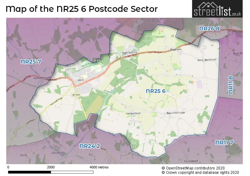
The NR25 6 Postcode shares a border with NR11 7 (Erpingham, Aldborough, Hanworth), NR11 8 (Mundesley, Southrepps, Roughton), NR24 2 (Briston, MELTON CONSTABLE, Edgefield), NR25 7 (Blakeney, Weybourne, Cley) and NR26 8 (SHERINGHAM, Beeston Regis, Upper Sheringham).
The sector is within the post town of HOLT.
NR25 6 is a postcode sector within the NR25 postcode district which is within the NR Norwich postcode area.
The Royal Mail delivery office for the NR25 6 postal sector is the Holt Delivery Office.
The area of the NR25 6 postcode sector is 13.61 square miles which is 35.24 square kilometres or 8,707.30 square acres.

Map of the NR25 6 Postcode Sector
Explore the NR25 6 postcode sector by using our free interactive map.
| N | R | 2 | 5 | - | 6 | X | X |
| N | R | 2 | 5 | Space | 6 | Letter | Letter |
Official List of Streets
HOLT (115 Streets)
West Beckham (5 Streets)
High Kelling (16 Streets)
Hempstead (11 Streets)
Baconsthorpe (9 Streets)
Bodham (14 Streets)
Barningham (2 Streets)
Lower Bodham (3 Streets)
Unofficial Streets or Alternative Spellings
Aylmerton
HOLT ROAD ASH TREE LANE BAKERS COURT BECKHAM PALACE ROAD BULL CLOSE CARPENTERS COTTAGES EDGEFIELD HILL GIPSIES LANE HIGH KELLING ROAD HOLT BYPASS JOLLY LANE LOCKHEART DRIVE MARLPIT ROAD MILL HOUSE LANE ORCHARD CLOSE OSIER LANE PLUMSTEAD ROAD ROSEACRE ESTATE SAINT ANDREWS CLOSE SCHOOL LOKE THE DRIFTWAYPlumstead
HEMPSTEAD ROADWeybourne
SANDY HILL LANEHunworth
HOLT ROADBayfield
CLEY ROADLetheringsett
RIVERSIDE ROADWeather Forecast for NR25 6
Press Button to Show Forecast for Sheringham Park
| Time Period | Icon | Description | Temperature | Rain Probability | Wind |
|---|---|---|---|---|---|
| 09:00 to 12:00 | Overcast | 6.0°C (feels like 4.0°C) | 47.00% | WSW 9 mph | |
| 12:00 to 15:00 | Light rain | 7.0°C (feels like 4.0°C) | 53.00% | NNW 18 mph | |
| 15:00 to 18:00 | Cloudy | 8.0°C (feels like 3.0°C) | 10.00% | N 18 mph | |
| 18:00 to 21:00 | Cloudy | 7.0°C (feels like 2.0°C) | 32.00% | NNW 18 mph | |
| 21:00 to 00:00 | Cloudy | 6.0°C (feels like 2.0°C) | 10.00% | NNW 18 mph |
Press Button to Show Forecast for Sheringham Park
| Time Period | Icon | Description | Temperature | Rain Probability | Wind |
|---|---|---|---|---|---|
| 00:00 to 03:00 | Cloudy | 6.0°C (feels like 1.0°C) | 11.00% | NNW 16 mph | |
| 03:00 to 06:00 | Cloudy | 5.0°C (feels like 1.0°C) | 13.00% | NNW 18 mph | |
| 06:00 to 09:00 | Overcast | 5.0°C (feels like 0.0°C) | 19.00% | NNW 18 mph | |
| 09:00 to 12:00 | Cloudy | 6.0°C (feels like 1.0°C) | 9.00% | NNW 20 mph | |
| 12:00 to 15:00 | Light rain shower (day) | 7.0°C (feels like 2.0°C) | 32.00% | NNW 20 mph | |
| 15:00 to 18:00 | Light rain shower (day) | 7.0°C (feels like 3.0°C) | 33.00% | NNW 20 mph | |
| 18:00 to 21:00 | Cloudy | 6.0°C (feels like 2.0°C) | 11.00% | NNW 18 mph | |
| 21:00 to 00:00 | Partly cloudy (night) | 6.0°C (feels like 2.0°C) | 7.00% | N 13 mph |
Press Button to Show Forecast for Sheringham Park
| Time Period | Icon | Description | Temperature | Rain Probability | Wind |
|---|---|---|---|---|---|
| 00:00 to 03:00 | Partly cloudy (night) | 5.0°C (feels like 2.0°C) | 4.00% | NNW 13 mph | |
| 03:00 to 06:00 | Partly cloudy (night) | 5.0°C (feels like 1.0°C) | 4.00% | NNW 13 mph | |
| 06:00 to 09:00 | Partly cloudy (day) | 6.0°C (feels like 2.0°C) | 5.00% | NNW 13 mph | |
| 09:00 to 12:00 | Light rain shower (day) | 7.0°C (feels like 4.0°C) | 28.00% | N 13 mph | |
| 12:00 to 15:00 | Light rain shower (day) | 8.0°C (feels like 5.0°C) | 29.00% | N 13 mph | |
| 15:00 to 18:00 | Cloudy | 8.0°C (feels like 5.0°C) | 9.00% | N 11 mph | |
| 18:00 to 21:00 | Cloudy | 7.0°C (feels like 5.0°C) | 7.00% | N 9 mph | |
| 21:00 to 00:00 | Cloudy | 5.0°C (feels like 2.0°C) | 8.00% | NNE 7 mph |
Press Button to Show Forecast for Sheringham Park
| Time Period | Icon | Description | Temperature | Rain Probability | Wind |
|---|---|---|---|---|---|
| 00:00 to 03:00 | Partly cloudy (night) | 4.0°C (feels like 2.0°C) | 6.00% | E 7 mph | |
| 03:00 to 06:00 | Cloudy | 4.0°C (feels like 1.0°C) | 8.00% | WNW 7 mph | |
| 06:00 to 09:00 | Cloudy | 5.0°C (feels like 2.0°C) | 6.00% | E 9 mph | |
| 09:00 to 12:00 | Cloudy | 8.0°C (feels like 6.0°C) | 9.00% | NNE 9 mph | |
| 12:00 to 15:00 | Cloudy | 9.0°C (feels like 7.0°C) | 12.00% | W 9 mph | |
| 15:00 to 18:00 | Cloudy | 10.0°C (feels like 8.0°C) | 11.00% | SE 9 mph | |
| 18:00 to 21:00 | Cloudy | 9.0°C (feels like 7.0°C) | 8.00% | SE 9 mph | |
| 21:00 to 00:00 | Cloudy | 7.0°C (feels like 4.0°C) | 8.00% | SE 11 mph |
Schools and Places of Education Within the NR25 6 Postcode Sector
Holt Community Primary School
Community school
Norwich Road, Holt, Norfolk, NR25 6SG
Head: Mr Simon Walters
Ofsted Rating: Good
Inspection: 2018-06-05 (2149 days ago)
Website: Visit Holt Community Primary School Website
Phone: 01263713107
Number of Pupils: 188
House Prices in the NR25 6 Postcode Sector
| Type of Property | 2018 Average | 2018 Sales | 2017 Average | 2017 Sales | 2016 Average | 2016 Sales | 2015 Average | 2015 Sales |
|---|---|---|---|---|---|---|---|---|
| Detached | £374,394 | 91 | £394,650 | 94 | £360,887 | 81 | £348,412 | 73 |
| Semi-Detached | £272,231 | 40 | £258,101 | 34 | £257,682 | 11 | £218,699 | 22 |
| Terraced | £263,841 | 46 | £220,504 | 24 | £212,103 | 14 | £232,229 | 24 |
| Flats | £193,111 | 9 | £160,333 | 3 | £168,242 | 6 | £178,983 | 20 |
Important Postcodes NR25 6 in the Postcode Sector
NR25 6DA is the postcode for Corpusty & Holt Childrens Centre, Charles Road, WORKSHOP, Holt Community Hub, Charles Road, and Holt Community Hub, Charles Road
NR25 6QA is the postcode for PINEHEATH, Norfolk Community Health and Care NHS Trust, Kelling Hospital, Holt Medical Practice, Kelling Hospital,, SIMPSON CENTRE, Norfolk Community Health and Care NHS Trust, Kelling Hospital, Norfolk Community Health and Care NHS Trust, Kelling Hospital, OT Physio & Simpson Centre, Norfolk Community Health and Care NHS Trust, Kelling Hospital, and HOUSE BLOCK, Norfolk Community Health and Care NHS Trust, Kelling Hospital
NR25 6SG is the postcode for JUNIOR BUILDING, Holt Community Primary School, Norwich Road
| The NR25 6 Sector is within these Local Authorities |
|
|---|---|
| The NR25 6 Sector is within these Counties |
|
| The NR25 6 Sector is within these Water Company Areas |
|