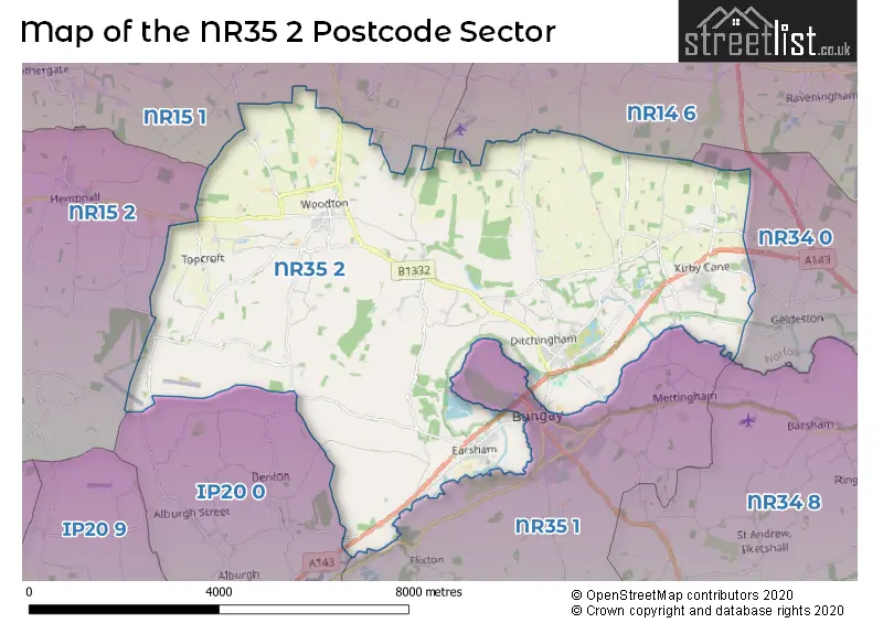
The NR35 2 postcode sector stands on the Norfolk and Suffolk border.
Did you know? According to the 2021 Census, the NR35 2 postcode sector is home to a bustling 5,425 residents!
Given that each sector allows for 400 unique postcode combinations. Letters C, I, K, M, O and V are not allowed in the last two letters of a postcode. With 236 postcodes already in use, this leaves 164 units available.
The largest settlement in the NR35 2 postal code is Ditchingham followed by Earsham, and Ellingham.
The NR35 2 Postcode shares a border with NR34 0 (Gillingham, Aldeby, Toft Monks), NR35 1 (BUNGAY, Flixton, Mettingham), NR14 6 (Loddon, Chedgrave, Thurlton), NR15 1 (Brooke, Newton Flotman, Tasburgh), NR15 2 (Long Stratton, Hempnall, Tharston) and IP20 0 (Alburgh, Metfield, Denton).
The sector is within the post town of BUNGAY.
NR35 2 is a postcode sector within the NR35 postcode district which is within the NR Norwich postcode area.
The Royal Mail delivery office for the NR35 2 postal sector is the Bungay Delivery Office.
The area of the NR35 2 postcode sector is 27.60 square miles which is 71.48 square kilometres or 17,662.49 square acres.
Waterways within the NR35 2 postcode sector include the River Waveney.

Map of the NR35 2 Postcode Sector
Explore the NR35 2 postcode sector by using our free interactive map.
| N | R | 3 | 5 | - | 2 | X | X |
| N | R | 3 | 5 | Space | 2 | Letter | Letter |
Official List of Streets
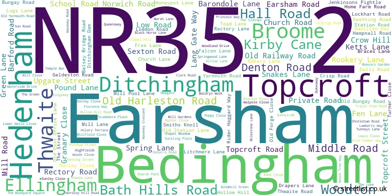
Ditchingham (38 Streets)
Topcroft (11 Streets)
Earsham (27 Streets)
Ellingham (17 Streets)
Thwaite (3 Streets)
Woodton (19 Streets)
Kirby Cane (13 Streets)
Broome (11 Streets)
Hedenham (9 Streets)
Unofficial Streets or Alternative Spellings
Loddon
BUNGAY ROAD INGLOSS LANEMundham
BIRCH WAY BUNGAY ROADSeething
UPGATE ROADBrooke
NORWICH ROAD WOODTON ROADBUNGAY
BRIDGE STREET EARSHAM STREET WAINFORD ROADDenton
MIDDLE ROADAlburgh
DENTON ROADHempnall
SPRING LANEWeather Forecast for NR35 2
Press Button to Show Forecast for Hedenham
| Time Period | Icon | Description | Temperature | Rain Probability | Wind |
|---|---|---|---|---|---|
| 09:00 to 12:00 | Overcast | 7.0°C (feels like 5.0°C) | 18.00% | WSW 7 mph | |
| 12:00 to 15:00 | Light rain | 8.0°C (feels like 6.0°C) | 53.00% | WNW 9 mph | |
| 15:00 to 18:00 | Light rain | 9.0°C (feels like 5.0°C) | 49.00% | N 16 mph | |
| 18:00 to 21:00 | Cloudy | 7.0°C (feels like 4.0°C) | 7.00% | NNW 11 mph | |
| 21:00 to 00:00 | Overcast | 5.0°C (feels like 2.0°C) | 14.00% | NNW 9 mph |
Press Button to Show Forecast for Hedenham
| Time Period | Icon | Description | Temperature | Rain Probability | Wind |
|---|---|---|---|---|---|
| 00:00 to 03:00 | Overcast | 5.0°C (feels like 2.0°C) | 11.00% | NW 9 mph | |
| 03:00 to 06:00 | Overcast | 4.0°C (feels like 1.0°C) | 10.00% | NNW 9 mph | |
| 06:00 to 09:00 | Cloudy | 5.0°C (feels like 1.0°C) | 10.00% | NW 11 mph | |
| 09:00 to 12:00 | Overcast | 7.0°C (feels like 3.0°C) | 14.00% | NNW 16 mph | |
| 12:00 to 15:00 | Light rain shower (day) | 8.0°C (feels like 4.0°C) | 29.00% | NNW 16 mph | |
| 15:00 to 18:00 | Cloudy | 8.0°C (feels like 4.0°C) | 11.00% | NNW 16 mph | |
| 18:00 to 21:00 | Partly cloudy (day) | 6.0°C (feels like 3.0°C) | 8.00% | NNW 11 mph | |
| 21:00 to 00:00 | Cloudy | 5.0°C (feels like 2.0°C) | 7.00% | NW 9 mph |
Press Button to Show Forecast for Hedenham
| Time Period | Icon | Description | Temperature | Rain Probability | Wind |
|---|---|---|---|---|---|
| 00:00 to 03:00 | Cloudy | 4.0°C (feels like 1.0°C) | 6.00% | NW 7 mph | |
| 03:00 to 06:00 | Cloudy | 4.0°C (feels like 1.0°C) | 5.00% | NW 9 mph | |
| 06:00 to 09:00 | Partly cloudy (day) | 5.0°C (feels like 2.0°C) | 3.00% | NW 7 mph | |
| 09:00 to 12:00 | Cloudy | 8.0°C (feels like 5.0°C) | 11.00% | N 11 mph | |
| 12:00 to 15:00 | Light rain shower (day) | 9.0°C (feels like 7.0°C) | 29.00% | NNW 9 mph | |
| 15:00 to 18:00 | Light rain shower (day) | 9.0°C (feels like 7.0°C) | 31.00% | NNW 9 mph | |
| 18:00 to 21:00 | Partly cloudy (day) | 8.0°C (feels like 6.0°C) | 6.00% | NNE 7 mph | |
| 21:00 to 00:00 | Partly cloudy (night) | 4.0°C (feels like 2.0°C) | 2.00% | NNE 4 mph |
Press Button to Show Forecast for Hedenham
| Time Period | Icon | Description | Temperature | Rain Probability | Wind |
|---|---|---|---|---|---|
| 00:00 to 03:00 | Partly cloudy (night) | 3.0°C (feels like 1.0°C) | 2.00% | W 4 mph | |
| 03:00 to 06:00 | Partly cloudy (night) | 3.0°C (feels like 1.0°C) | 4.00% | W 4 mph | |
| 06:00 to 09:00 | Cloudy | 5.0°C (feels like 3.0°C) | 7.00% | W 4 mph | |
| 09:00 to 12:00 | Cloudy | 9.0°C (feels like 7.0°C) | 9.00% | W 7 mph | |
| 12:00 to 15:00 | Cloudy | 10.0°C (feels like 9.0°C) | 11.00% | NNW 7 mph | |
| 15:00 to 18:00 | Overcast | 10.0°C (feels like 9.0°C) | 17.00% | S 7 mph | |
| 18:00 to 21:00 | Cloudy | 9.0°C (feels like 8.0°C) | 10.00% | SSE 7 mph | |
| 21:00 to 00:00 | Cloudy | 7.0°C (feels like 5.0°C) | 8.00% | SSE 7 mph |
Schools and Places of Education Within the NR35 2 Postcode Sector
Ditchingham Church of England Primary Academy
Academy sponsor led
Rider Haggard Way, Bungay, Suffolk, NR35 2RE
Head: Mrs Heather Brand
Ofsted Rating: Good
Inspection: 2022-05-26 (698 days ago)
Website: Visit Ditchingham Church of England Primary Academy Website
Phone: 01986893277
Number of Pupils: 85
Ellingham VC Primary School
Voluntary controlled school
Church Road, Bungay, Suffolk, NR35 2PZ
Head: Miss Dawn Read
Ofsted Rating: Good
Inspection: 2023-07-06 (292 days ago)
Website: Visit Ellingham VC Primary School Website
Phone: 01508518250
Number of Pupils: 105
Turnstone House School
Other independent special school
Birtwick Park, Bungay, Suffolk, NR35 2HP
Head: Mrs Claire Leeder
Ofsted Rating: Good
Inspection: 2022-03-17 (768 days ago)
Website: Visit Turnstone House School Website
Phone: 01508518678
Number of Pupils: 9
Woodton Primary School
Community school
Norwich Road, Bungay, Suffolk, NR35 2LL
Head: Miss Dawn Read
Ofsted Rating: Good
Inspection: 2020-03-12 (1503 days ago)
Website: Visit Woodton Primary School Website
Phone: 01508482294
Number of Pupils: 57
House Prices in the NR35 2 Postcode Sector
| Type of Property | 2018 Average | 2018 Sales | 2017 Average | 2017 Sales | 2016 Average | 2016 Sales | 2015 Average | 2015 Sales |
|---|---|---|---|---|---|---|---|---|
| Detached | £363,057 | 42 | £351,447 | 43 | £267,686 | 51 | £296,368 | 53 |
| Semi-Detached | £215,521 | 24 | £222,724 | 19 | £217,248 | 22 | £199,918 | 16 |
| Terraced | £176,591 | 11 | £199,767 | 15 | £182,746 | 14 | £175,708 | 42 |
| Flats | £159,083 | 6 | £176,000 | 2 | £157,769 | 18 | £143,800 | 13 |
Important Postcodes NR35 2 in the Postcode Sector
NR35 2PZ is the postcode for Ellingham V C Primary School, Ellingham
NR35 2RE is the postcode for Ditchingham Primary School, Rider Haggard Way
NR35 2TF is the postcode for Earsham CE VA Primary School, School Road
| The NR35 2 Sector is within these Local Authorities |
|
|---|---|
| The NR35 2 Sector is within these Counties |
|
| The NR35 2 Sector is within these Water Company Areas |
|