The NR6 5 postcode sector is within the county of Norfolk.
Did you know? According to the 2021 Census, the NR6 5 postcode sector is home to a bustling 7,565 residents!
Given that each sector allows for 400 unique postcode combinations. Letters C, I, K, M, O and V are not allowed in the last two letters of a postcode. With 196 postcodes already in use, this leaves 204 units available.
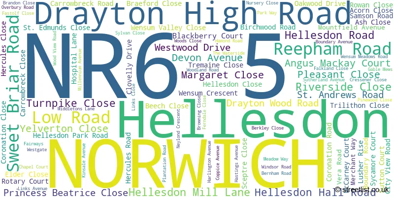
The largest settlements in the NR6 5 postal code are NORWICH and Hellesdon.
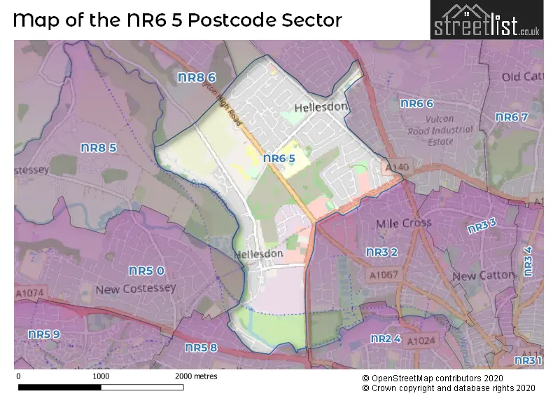
The NR6 5 Postcode shares a border with NR8 5 (Costessey), NR8 6 (Taverham, Drayton, Ringland), NR10 3 (Horsford, Spixworth, Horsham St. Faith), NR3 2 (NORWICH, Sweet Briar Road Industrial Estate), NR5 8 (NORWICH), NR6 6 (NORWICH) and NR5 0 (NORWICH, New Costessey).
The sector is within the post town of NORWICH.
NR6 5 is a postcode sector within the NR6 postcode district which is within the NR Norwich postcode area.
The Royal Mail delivery office for the NR6 5 postal sector is the Norwich Delivery Office.
The area of the NR6 5 postcode sector is 1.88 square miles which is 4.87 square kilometres or 1,202.41 square acres.
Waterways within the NR6 5 postcode sector include the River Wensum.

Map of the NR6 5 Postcode Sector
Explore the NR6 5 postcode sector by using our free interactive map.
| N | R | 6 | - | 5 | X | X |
| N | R | 6 | Space | 5 | Letter | Letter |
Official List of Streets
Hellesdon (19 Streets)
NORWICH (74 Streets)
Unofficial Streets or Alternative Spellings
NORWICH
AMSTERDAM WAY AYLSHAM ROAD BUSH ROAD COTTINGHAMS DRIVE CROMER ROAD DENNIS ROAD DRAYTON ROAD FIRS ROAD GABLE MEWS GOWING ROAD HAWTHORNE AVENUE HEATHER AVENUE JEX ROAD MARSHALL ROAD MEADOW CLOSE MILE CROSS LANE RYE AVENUE SPYNKE ROAD WENSUM MEADOWS ROAD WHIFFLER ROAD ALSTON ROAD CARROWBECK CLOSE HAWTHORN AVENUE MARRIOTTS WAY MIDDLETONS COURT MILLENIUM AVENUE NORTHGATE ORCHARD DRIVE SAINT ANDREWS ROAD SAINT EDMUNDS CLOSE TRILITHORN CLOSE WOODLAND CLOSEDrayton
DRAYTON HIGH ROAD LOW ROADHorsford
HOLT ROADAlderford
REEPHAM ROADWeather Forecast for NR6 5
Press Button to Show Forecast for Norwich Youth Hostel
| Time Period | Icon | Description | Temperature | Rain Probability | Wind |
|---|---|---|---|---|---|
| 06:00 to 09:00 | Cloudy | 5.0°C (feels like 2.0°C) | 5.00% | SW 9 mph | |
| 09:00 to 12:00 | Overcast | 8.0°C (feels like 5.0°C) | 12.00% | W 11 mph | |
| 12:00 to 15:00 | Heavy rain | 7.0°C (feels like 4.0°C) | 79.00% | NNW 11 mph | |
| 15:00 to 18:00 | Cloudy | 7.0°C (feels like 5.0°C) | 32.00% | NW 7 mph | |
| 18:00 to 21:00 | Partly cloudy (day) | 7.0°C (feels like 4.0°C) | 5.00% | N 7 mph | |
| 21:00 to 00:00 | Clear night | 4.0°C (feels like 2.0°C) | 0.00% | NW 4 mph |
Press Button to Show Forecast for Norwich Youth Hostel
| Time Period | Icon | Description | Temperature | Rain Probability | Wind |
|---|---|---|---|---|---|
| 00:00 to 03:00 | Clear night | 3.0°C (feels like 1.0°C) | 0.00% | WNW 4 mph | |
| 03:00 to 06:00 | Cloudy | 2.0°C (feels like 0.0°C) | 3.00% | WNW 4 mph | |
| 06:00 to 09:00 | Cloudy | 4.0°C (feels like 3.0°C) | 3.00% | NW 4 mph | |
| 09:00 to 12:00 | Cloudy | 8.0°C (feels like 7.0°C) | 8.00% | NE 4 mph | |
| 12:00 to 15:00 | Overcast | 9.0°C (feels like 7.0°C) | 49.00% | E 7 mph | |
| 15:00 to 18:00 | Overcast | 9.0°C (feels like 8.0°C) | 14.00% | ENE 7 mph | |
| 18:00 to 21:00 | Cloudy | 8.0°C (feels like 6.0°C) | 6.00% | E 7 mph | |
| 21:00 to 00:00 | Partly cloudy (night) | 5.0°C (feels like 3.0°C) | 4.00% | ENE 4 mph |
Press Button to Show Forecast for Norwich Youth Hostel
| Time Period | Icon | Description | Temperature | Rain Probability | Wind |
|---|---|---|---|---|---|
| 00:00 to 03:00 | Partly cloudy (night) | 4.0°C (feels like 2.0°C) | 6.00% | NE 4 mph | |
| 03:00 to 06:00 | Partly cloudy (night) | 4.0°C (feels like 2.0°C) | 8.00% | NE 4 mph | |
| 06:00 to 09:00 | Cloudy | 6.0°C (feels like 4.0°C) | 11.00% | ENE 7 mph | |
| 09:00 to 12:00 | Cloudy | 9.0°C (feels like 7.0°C) | 17.00% | ENE 9 mph | |
| 12:00 to 15:00 | Overcast | 11.0°C (feels like 9.0°C) | 16.00% | ENE 9 mph | |
| 15:00 to 18:00 | Overcast | 11.0°C (feels like 9.0°C) | 15.00% | ENE 9 mph | |
| 18:00 to 21:00 | Cloudy | 10.0°C (feels like 8.0°C) | 12.00% | ENE 11 mph | |
| 21:00 to 00:00 | Cloudy | 9.0°C (feels like 7.0°C) | 19.00% | ENE 9 mph |
Press Button to Show Forecast for Norwich Youth Hostel
| Time Period | Icon | Description | Temperature | Rain Probability | Wind |
|---|---|---|---|---|---|
| 00:00 to 03:00 | Light rain | 9.0°C (feels like 7.0°C) | 51.00% | ENE 11 mph | |
| 03:00 to 06:00 | Heavy rain | 10.0°C (feels like 8.0°C) | 70.00% | E 9 mph | |
| 06:00 to 09:00 | Light rain shower (day) | 10.0°C (feels like 8.0°C) | 43.00% | SE 9 mph | |
| 09:00 to 12:00 | Light rain shower (day) | 13.0°C (feels like 10.0°C) | 39.00% | SSE 13 mph | |
| 12:00 to 15:00 | Light rain shower (day) | 14.0°C (feels like 11.0°C) | 47.00% | SSE 16 mph | |
| 15:00 to 18:00 | Light rain shower (day) | 13.0°C (feels like 10.0°C) | 42.00% | SSW 13 mph | |
| 18:00 to 21:00 | Light rain shower (day) | 12.0°C (feels like 10.0°C) | 34.00% | SW 9 mph | |
| 21:00 to 00:00 | Clear night | 9.0°C (feels like 7.0°C) | 5.00% | WSW 9 mph |
Schools and Places of Education Within the NR6 5 Postcode Sector
Firside Junior School
Academy converter
Firside Junior School, Norwich, , NR6 5NF
Head: Mrs Rosalind Robinson
Ofsted Rating: Good
Inspection: 2019-06-26 (1765 days ago)
Website: Visit Firside Junior School Website
Phone: 01603426550
Number of Pupils: 357
Hellesdon High School
Academy converter
187 Middletons Lane, Norwich, Norfolk, NR6 5SB
Head: Mr Tom Rolfe
Ofsted Rating: Requires improvement
Inspection: 2023-10-04 (204 days ago)
Website: Visit Hellesdon High School Website
Phone: 01603424711
Number of Pupils: 1577
Kinsale Infant School
Community school
Kinsale Avenue, Norwich, Norfolk, NR6 5SG
Head: Ms Stacey Coleman
Ofsted Rating: Good
Inspection: 2020-01-23 (1554 days ago)
Website: Visit Kinsale Infant School Website
Phone: 01603405227
Number of Pupils: 131
Kinsale Junior School
Academy converter
Kinsale Avenue, Norwich, Norfolk, NR6 5SG
Head: Mrs Roz Robinson
Ofsted Rating: Good
Inspection: 2023-09-14 (224 days ago)
Website: Visit Kinsale Junior School Website
Phone: 01603425662
Number of Pupils: 218
House Prices in the NR6 5 Postcode Sector
| Type of Property | 2018 Average | 2018 Sales | 2017 Average | 2017 Sales | 2016 Average | 2016 Sales | 2015 Average | 2015 Sales |
|---|---|---|---|---|---|---|---|---|
| Detached | £278,000 | 31 | £261,086 | 49 | £294,675 | 48 | £258,487 | 39 |
| Semi-Detached | £221,025 | 74 | £223,542 | 65 | £202,525 | 67 | £199,051 | 48 |
| Terraced | £182,727 | 11 | £188,513 | 19 | £173,931 | 8 | £177,292 | 12 |
| Flats | £141,500 | 4 | £174,143 | 7 | £136,000 | 7 | £141,857 | 7 |
Important Postcodes NR6 5 in the Postcode Sector
NR6 5BE is the postcode for Grebe House, Hellesdon Hospital, Drayton High Road, MARRIOTT EDUCATION, Hellesdon Hospital, Drayton High Road, Harnser House, Hellesdon Hospital, Grebe House, Hellesdon Hospital, Norfolk and Waveney Mental Health NHS Foundation Trust, Hellesdon Hospital, THE PEDDARS CENTRE, Hellesdon Hospital, Drayton High Road, Justin Gardner House, Hellesdon Hospital, Hellesdon Hospital, Drayton High Road, KINGFISHER HOUSE, Hellesdon Hospital, Drayton High Road, WEAVERS CENTRE, Hellesdon Hospital, Drayton High Road, Justin Gardner House, Hellesdon Hospital, Drayton High Road, and Harnser House, Hellesdon Hospital, Drayton High Road
NR6 5DR is the postcode for The Red House, Hellesdon Park Industrial Estate
NR6 5NA is the postcode for East of England Ambulance NHS Trust, Hospital Lane
NR6 5NF is the postcode for Firside Junior School, Middletons Lane, KITCHEN & DINING BLOCK, Firside Junior School, Middletons Lane, and Hellesdon Firside Middle School, Middletons Lane
NR6 5QJ is the postcode for Hellesdon Medical Practice, 343 Reepham Road
NR6 5SB is the postcode for E, F AND SIXTH FORM BLOCK, Hellesdon High School, Middletons Lane, SPORTS HALL, Hellesdon High School, 187 Middletons Lane, MUSIC BLOCK, Hellesdon High School, Middletons Lane, K BLOCK, Hellesdon High School, 187 Middletons Lane, MAIN SCHOOL BUILDING, Hellesdon High School, Middletons Lane, and CDT BLOCK, Hellesdon High School, Middletons Lane
NR6 5SG is the postcode for Kinsale Infant School, Kinsale Avenue,, Kinsale Junior School, Kinsale Avenue, Hellesdon, Kinsale Junior School, Kinsale Avenue, and Kinsale Infant School, Kinsale Avenue
NR6 5SR is the postcode for Hellesdon Library, Middletons Lane
| The NR6 5 Sector is within these Local Authorities |
|
|---|---|
| The NR6 5 Sector is within these Counties |
|
| The NR6 5 Sector is within these Water Company Areas |
|