The NW1 2 postcode sector is within the county of Greater London.
Did you know? According to the 2021 Census, the NW1 2 postcode sector is home to a bustling 2,095 residents!
Given that each sector allows for 400 unique postcode combinations. Letters C, I, K, M, O and V are not allowed in the last two letters of a postcode. With 102 postcodes already in use, this leaves 298 units available.
The NW1 2 postal code covers the settlement of LONDON .
The NW1 2 Postcode shares a border with N1 9 (ISLINGTON ), NW1 3 (LONDON ), N1C 4 (LONDON ), NW1 7 (LONDON ), NW1 0 (LONDON ), W1T 7 (LONDON ), WC1E 6 (LONDON ), WC1H 0 (LONDON ), WC1H 9 (LONDON ), WC1H 8 (LONDON ), NW1 1 (LONDON ) and WC1X 8 (LONDON ).
The sector is within the post town of LONDON.
NW1 2 is a postcode sector within the NW1 postcode district which is within the NW North West London postcode area.
The Royal Mail delivery office for the NW1 2 postal sector is the Nwdelivery Office.
The area of the NW1 2 postcode sector is 0.17 square miles which is 0.45 square kilometres or 110.00 square acres.

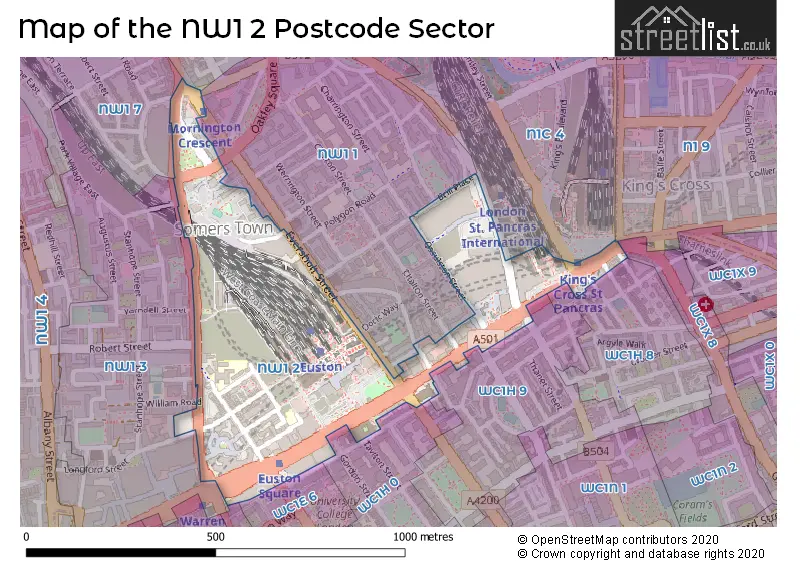
Map of the NW1 2 Postcode Sector
Explore the NW1 2 postcode sector by using our free interactive map.
| N | W | 1 | - | 2 | X | X |
| N | W | 1 | Space | 2 | Letter | Letter |
Official List of Streets
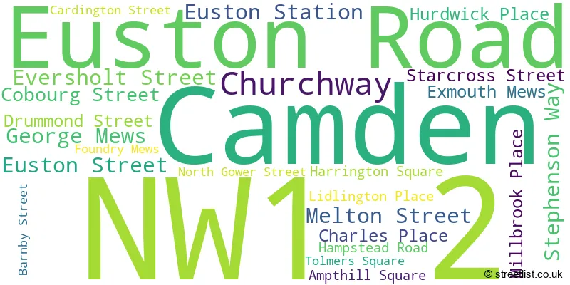
Camden (24 Streets)
Unofficial Streets or Alternative Spellings
Camden
ARGYLE STREET BELGROVE STREET BIRKENHEAD STREET BRILL PLACE BROCK STREET CAMDEN HIGH STREET CHALTON STREET CHRISTOPHER PLACE CRESTFIELD STREET CROWNDALE ROAD DORIC WAY DRUMMOND CRESCENT ENDSLEIGH GARDENS GORDON STREET GOWER STREET GRAFTON PLACE GRAYS INN ROAD JUDD STREET LANCING STREET MABLEDON PLACE MIDLAND ROAD MORNINGTON CRESCENT NETLEY STREET OSSULSTON STREET PANCRAS ROAD PHOENIX ROAD PRINCE OF WALES PASSAGE ROBERT STREET UPPER WOBURN PLACE YORK WAY COOPERS LANE DANGOOR WALK EUSTON GROVE EUSTON SQUARE EUSTON UNDERPASS REGNART BUILDINGS THE ARCADE WELLESLEY PLACEWeather Forecast for NW1 2
Press Button to Show Forecast for St Pancras Youth Hostel
| Time Period | Icon | Description | Temperature | Rain Probability | Wind |
|---|---|---|---|---|---|
| 00:00 to 03:00 | Overcast | 9.0°C (feels like 6.0°C) | 57.00% | WSW 11 mph | |
| 03:00 to 06:00 | Overcast | 10.0°C (feels like 7.0°C) | 15.00% | W 11 mph | |
| 06:00 to 09:00 | Cloudy | 10.0°C (feels like 8.0°C) | 43.00% | WNW 9 mph | |
| 09:00 to 12:00 | Light rain shower (day) | 11.0°C (feels like 9.0°C) | 31.00% | NW 13 mph | |
| 12:00 to 15:00 | Cloudy | 12.0°C (feels like 10.0°C) | 11.00% | NW 13 mph | |
| 15:00 to 18:00 | Cloudy | 12.0°C (feels like 10.0°C) | 12.00% | N 13 mph | |
| 18:00 to 21:00 | Cloudy | 10.0°C (feels like 8.0°C) | 11.00% | NNE 9 mph | |
| 21:00 to 00:00 | Partly cloudy (night) | 8.0°C (feels like 6.0°C) | 4.00% | NNE 9 mph |
Press Button to Show Forecast for St Pancras Youth Hostel
| Time Period | Icon | Description | Temperature | Rain Probability | Wind |
|---|---|---|---|---|---|
| 00:00 to 03:00 | Clear night | 7.0°C (feels like 4.0°C) | 2.00% | N 9 mph | |
| 03:00 to 06:00 | Clear night | 5.0°C (feels like 2.0°C) | 1.00% | NNW 9 mph | |
| 06:00 to 09:00 | Cloudy | 5.0°C (feels like 2.0°C) | 5.00% | NNW 9 mph | |
| 09:00 to 12:00 | Overcast | 8.0°C (feels like 5.0°C) | 8.00% | N 11 mph | |
| 12:00 to 15:00 | Overcast | 10.0°C (feels like 7.0°C) | 8.00% | N 11 mph | |
| 15:00 to 18:00 | Overcast | 11.0°C (feels like 9.0°C) | 10.00% | N 9 mph | |
| 18:00 to 21:00 | Overcast | 10.0°C (feels like 8.0°C) | 9.00% | NNE 9 mph | |
| 21:00 to 00:00 | Clear night | 8.0°C (feels like 6.0°C) | 2.00% | NNE 7 mph |
Press Button to Show Forecast for St Pancras Youth Hostel
| Time Period | Icon | Description | Temperature | Rain Probability | Wind |
|---|---|---|---|---|---|
| 00:00 to 03:00 | Overcast | 7.0°C (feels like 5.0°C) | 8.00% | NNE 4 mph | |
| 03:00 to 06:00 | Partly cloudy (night) | 6.0°C (feels like 5.0°C) | 1.00% | N 4 mph | |
| 06:00 to 09:00 | Overcast | 6.0°C (feels like 4.0°C) | 8.00% | N 4 mph | |
| 09:00 to 12:00 | Overcast | 8.0°C (feels like 6.0°C) | 10.00% | N 7 mph | |
| 12:00 to 15:00 | Overcast | 10.0°C (feels like 8.0°C) | 11.00% | NNE 9 mph | |
| 15:00 to 18:00 | Overcast | 12.0°C (feels like 9.0°C) | 11.00% | NNE 9 mph | |
| 18:00 to 21:00 | Cloudy | 11.0°C (feels like 8.0°C) | 7.00% | NNE 11 mph | |
| 21:00 to 00:00 | Partly cloudy (night) | 9.0°C (feels like 6.0°C) | 3.00% | NE 9 mph |
Press Button to Show Forecast for St Pancras Youth Hostel
| Time Period | Icon | Description | Temperature | Rain Probability | Wind |
|---|---|---|---|---|---|
| 00:00 to 03:00 | Clear night | 7.0°C (feels like 5.0°C) | 4.00% | NNE 7 mph | |
| 03:00 to 06:00 | Clear night | 6.0°C (feels like 4.0°C) | 3.00% | NNE 7 mph | |
| 06:00 to 09:00 | Sunny day | 6.0°C (feels like 3.0°C) | 3.00% | NNE 7 mph | |
| 09:00 to 12:00 | Partly cloudy (day) | 9.0°C (feels like 6.0°C) | 3.00% | NNE 9 mph | |
| 12:00 to 15:00 | Cloudy | 11.0°C (feels like 9.0°C) | 8.00% | NE 9 mph | |
| 15:00 to 18:00 | Cloudy | 11.0°C (feels like 9.0°C) | 9.00% | NE 11 mph | |
| 18:00 to 21:00 | Cloudy | 11.0°C (feels like 8.0°C) | 8.00% | NE 9 mph | |
| 21:00 to 00:00 | Partly cloudy (night) | 9.0°C (feels like 6.0°C) | 3.00% | NE 9 mph |
House Prices in the NW1 2 Postcode Sector
| Type of Property | 2018 Average | 2018 Sales | 2017 Average | 2017 Sales | 2016 Average | 2016 Sales | 2015 Average | 2015 Sales |
|---|---|---|---|---|---|---|---|---|
| Detached | £0 | 0 | £0 | 0 | £0 | 0 | £0 | 0 |
| Semi-Detached | £0 | 0 | £0 | 0 | £0 | 0 | £0 | 0 |
| Terraced | £2,890,000 | 1 | £0 | 0 | £0 | 0 | £1,022,000 | 1 |
| Flats | £591,642 | 7 | £806,786 | 7 | £898,462 | 13 | £803,192 | 9 |
Important Postcodes NW1 2 in the Postcode Sector
NW1 2BE is the postcode for The Wellcome Trust, 183-193 Euston Road
NW1 2BJ is the postcode for FRIENDS HOUSE, Religious Society of Friends, Friends House, 173-177 Euston Road
NW1 2BU is the postcode for ELIZABETH GARRETT ANDERSON WING, University College Hospital, 235 Euston Road, UNIVERSITY COLLEGE HOSPITAL, 235 EUSTON ROAD, LONDON, and University College Hospital, 235 Euston Road
NW1 2DA is the postcode for University College London, 222 Euston Road
NW1 2DB is the postcode for British Library, 96 Euston Road, and PUBLIC AREAS, British Library, 96 Euston Road
NW1 2DH is the postcode for Euston Fire Station,, 172 Euston Road,, and Euston Fire Station, 172 Euston Road
NW1 2HE is the postcode for Wolfson House, 2-10 Stephenson Way
NW1 2HS is the postcode for BRITISH TRANSPORT POLICE OFFICES, Network Rail Ltd, Euston Station
NW1 2LS is the postcode for The Margarete Centre, St. James' House, 108 Hampstead Road
NW1 2LY is the postcode for Maria Fidelis Convent Lower School, North Gower Street
NW1 2NJ is the postcode for Prankard House, 195 North Gover Street
NW1 2PL is the postcode for Stephenson House, 67-87, Hampstead Road
| The NW1 2 Sector is within these Local Authorities |
|
|---|---|
| The NW1 2 Sector is within these Counties |
|
| The NW1 2 Sector is within these Water Company Areas |
|
Tourist Attractions within the NW1 2 Postcode Area
We found 2 visitor attractions within the NW1 postcode area
| Crypt Gallery & 13th Century Undercroft |
|---|
| Museums & Art Galleries |
| Museum and / or Art Gallery |
| View Crypt Gallery & 13th Century Undercroft on Google Maps |
| British Library |
| Museums & Art Galleries |
| Museum and / or Art Gallery |
| View British Library on Google Maps |